BlockBefore
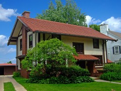
Photograph of Robert M. La Follette House
Photograph by National Park Service photographer, Public domain. Via Wikimedia Commons.

Robert M. LaFollette House

A National Historic Landmark. Built in 1849. Listed on the National Register of Historic Places in 1966.

From the record

“La Follette House is a historic house located at 733 Lakewood Boulevard in Maple Bluff, Wisconsin, United States. Congressman and presidential candidate, from 1905 until his death in 1925.”

Wikipedia article Robert M. La Follette House, CC BY-SA 4.0.

One of 238 National Register listings published here for Dane County · listed in 1966 · category: Building · built in 1849 · a National Historic Landmark.

Sources: the Wikipedia article · the case file at the National Archives · the National Register database, National Park Service

The listing

  • National Historic Landmark. The highest federal designation, held by about 2,600 places in the country against roughly 100,000 Register listings.
  • What is counted as historic. The nomination lists 1 building as contributing to the listing.
  • Listed as. LaFollette, Robert M., House - the National Register files a house under its owner's surname.
  • Address. 733 Lakewood Blvd., Maple Bluff, 53704
  • When was it listed? October 1966
  • Category. building
  • Village. Maple Bluff village
  • When was it built? 1849
  • National Register reference number. 66000020 - the number the National Park Service assigned this property when it was listed, and the key its nomination file is catalogued under at the National Archives.

Fires near this property

31 since 2003

Regional context, not property-specific evidence. The federal wildfire occurrence database lists 31 fires within 5 miles of Robert M. LaFollette House between 2003 and 2020, burning about 560 acres in total. None started naturally. 1 was recorded as arson. Distance is straight-line from the map coordinates, so a fire counted here may appear on a neighbouring settlement's page as well.

Reported cause Fires
Missing data/not specified/undetermined25
Recreation and ceremony1
Misuse of fire by a minor1
Arson/incendiarism1
Smoking1
Debris and open burning1
Equipment and vehicle use1

The most recent of them, most recent first, with the day each was reported and the service that recorded it.

DateCause SizeReported by Name on the report
17 September 2020Missing data/not specified/undetermined1.0 acresWisconsin Department of Natural Resources2021851
16 September 2018Missing data/not specified/undeterminedunder an acreWisconsin Department of Natural Resources1822998
3 August 2018Missing data/not specified/undeterminedunder an acreWisconsin Department of Natural Resources1818632
29 August 2020Arson/incendiarismunder an acreWisconsin Department of Natural Resources2020209
24 August 2020Missing data/not specified/undeterminedunder an acreWisconsin Department of Natural Resources2019797
18 August 2020Missing data/not specified/undeterminedunder an acreWisconsin Department of Natural Resources1225
26 July 2020Missing data/not specified/undetermined1.0 acresWisconsin Department of Natural Resources2017339
24 June 2018Missing data/not specified/undeterminedunder an acreWisconsin Department of Natural Resources1815050

Every fire recorded in Dane County

Mines and quarries near this property

10 within 5 miles

Regional context, not property-specific evidence. The federal mineral resources record lists 10 workings within 5 miles of Robert M. LaFollette House: 5 producers, 3 unknowns, 2 past producers. 5 still produce. What was taken out: Sand and Gravel, Construction, Stone, Stone, Crushed/Broken. Distance is straight-line from the map coordinates, so a quarry counted here may appear on a neighbouring settlement's page as well.

Where SiteCommodity StatusRecorded
Fess QuarryStoneUnknown
John Hensen QuarryStoneUnknown
Madison Stone Co Inc Ghost Hill QyStone, Crushed/BrokenProducer
Williams QuarryStone, Crushed/BrokenPast Producer
Blooming Grove PitSand and Gravel, ConstructionProducer
Engelhart Sand & Gravel PitSand and Gravel, ConstructionUnknown
Madison Airport PitSand and Gravel, ConstructionPast Producer
Norway Grove Gravel PlantSand and Gravel, ConstructionProducer
Westport PitSand and Gravel, ConstructionProducer
Yanggen PitSand and Gravel, ConstructionProducer

Every working recorded in Dane County

Storms near this property

26 since 2008

Regional context, not property-specific evidence. The National Weather Service names Maple Bluff, the town this property stands in, in 26 storm reports between 2008 and 2026: 14 hail, 6 thunderstorm wind, 2 flash flood, 2 tornado. No death or injury is recorded in these reports. Each account below is quoted exactly as the forecast office filed it, from the NOAA Storm Events Database, and each date opens the federal record of that event.

WhenEvent Place namedHarm What the report says
June 2014Tornado (EF1)Maple Bluff$300,000A tornado snapped and uprooted numerous large trees with some trees landing on homes and cars. Power poles and power lines knocked down. A roof removed from one home and a roof removed from a business. Shingle damage to other homes. Boats and small sailboats sunk or missing. An 80 pound canoe and two kayaks thrown.
October 2017Tornado (EF0)Maple Bluff$250,000An EF0 tornado started near the intersection of S. First St. and Winnebago St. in Madison and tracked over 9 miles to Sun Prairie, paralleling Highway 151 for most of the path. In Madison, approximately, 200 trees were damaged or destroyed. Some of the trees landed on homes, garages, and vehicles. At least three households were displaced due to damage to their homes. The rear wall of a car wash collapsed, and the three-season porch of a home collapsed. A roof was partially torn away from a commercial building. Many power lines were downed with some arcing. In total, four commercial buildings and 12-18 homes sustained some damage. In Sun Prairie, near and east of the intersection of W. Main St. and O'Keeffe Ave., several traffic standards, streets signs, and construction barrels were damaged or knocked down. A truck topper was removed from a truck and a small wood shed was damaged. Several trees and branches were down, including a tree on a house.
May 2014Flash FloodMaple Bluff$40,000Many streets impassable in downtown Madison and the near east side of the city due to deep water with multiple vehicles being swept away or pushed into oncoming traffic. Some roads were closed, and manhole covers were removed by the rushing water from underneath. The eastbound beltline highway off-ramp to John Nolen Drive was closed due to deep water. The northbound side of South Park street intersecting with Wingra Drive was flooded. Some buildings were flooded near the Capital building.
June 2025Heavy RainMaple Bluff$25,000Heavy rain accumulating on the roof of a supermarket, due to clogged roof drains, caused a partial roof collapse. The store was partially flooded.
June 2022Thunderstorm WindMaple Bluff$15,000Numerous trees and power lines down. Debris flying past window on 8th story of office building.
May 2014Flash FloodMaple Bluff$10,000Water waist to chest deep near Warner Park including the 1500 block of Trailsway Drive. A vehicle was stuck in deep water in the intersection of Aberg and Huxley streets.
August 2024Thunderstorm WindMaple Bluff$3,000Several reports of trees down on the east side of Madison including some 1 foot diameter trees.
June 2020Thunderstorm WindMaple Bluff$3,000Scattered trees and power lines down on the north and east sides of Madison.
July 2016Thunderstorm WindMaple Bluff$1,000A five inch diameter tree landed on a road.
July 2015Thunderstorm WindMaple Bluff$1,000Ten to fifteen inch tree branches down.
April 2026HailMaple Bluff-Trained spotter reports 1 inch diameter hail near Maple Bluff.
April 2026HailMaple Bluff-Public report of 1 inch diameter hail near Maple Bluff.
April 2026HailMaple Bluff-Trained spotter reports 2.75 inch diameter hail in Maple Bluff.
April 2026HailMaple Bluff-Trained spotter reports 3.25 inch diameter hail on the east side of the city of Madison.
April 2026HailMaple Bluff-Trained spotter reports 3 inch diameter hail near Maple Bluff.
April 2026HailMaple Bluff-Trained spotter reports 2 inch diameter hail near Maple Bluff.
July 2016Thunderstorm WindMaple Bluff-Numerous trees snapped about halfway up, though some broke near weak points.
May 2025HailMaple Bluff-no account filed
October 2023HailMaple Bluff-no account filed
November 2022HailMaple Bluff-no account filed
June 2022HailMaple Bluff-no account filed
September 2022HailMaple Bluff-no account filed
June 2008Funnel CloudMaple Bluff-no account filed

Every storm recorded in Dane County

Map coverage status

No historic map-sheet match is published for this property yet. That does not mean no map exists. This record needs a coordinate-quality review before it can be joined to a sheet boundary. Browse the county's mapped places while that work is pending.

Listed places nearby

6 within 8 miles

Other National Register properties close enough to walk or drive between, ordered by distance from this one. Both positions come from the same geocoding pass that matched these properties to their map sheets.

Photograph PropertyDistance Listed
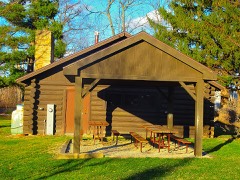
Maple Bluff Boy Scout Cabin0.6 miles2017
Coolidge Street-Myrtle Street Historic District1.3 miles2020
Lake View Sanatorium1.6 miles1993
Sherman Avenue Historic District1.7 miles1988
Tenney Park-Yahara River Parkway1.7 miles1999
Louis Hirsig House1.9 miles1974

Sources for this property

National Archives recordThe nomination case file for reference 66000020 in Record Group 79.
Wikipedia articleCommunity-written account of this property, licensed CC BY-SA.
Dane CountyAll 238 listed properties in this county.

Provenance

  • Listing record. National Park Service National Register of Historic Places, listed-properties dataset, current to 2026-05-22.
  • Map join. Address geocoded through the United States Census geocoder, then tested against the published boundary of every sheet in the USGS Historical Topographic Map Collection.
  • How this page is made. Listing fields come from federal records; map-sheet coverage is a labelled coordinate-to-boundary calculation, not a source-field claim.
  • Wildfire. Short, Karen C. 2022. Spatial wildfire occurrence data for the United States, 1992-2020 [FPA_FOD_20221014]. 6th Edition. Fort Collins, CO: Forest Service Research Data Archive. https://doi.org/10.2737/RDS-2013-0009.6 Collected with United States Government funding and usable without additional permissions or fees.
  • Mines and quarries. USGS Mineral Resources Data System (MRDS) https://mrdata.usgs.gov/mrds/ A work of the United States government, no copyright under 17 U.S.C. 105.
  • Storms. NOAA National Centers for Environmental Information, Storm Events Database https://www.ncei.noaa.gov/stormevents/ A work of the United States government, no copyright under 17 U.S.C. 105. Narratives are quoted verbatim from the National Weather Service report and are not edited or summarised.