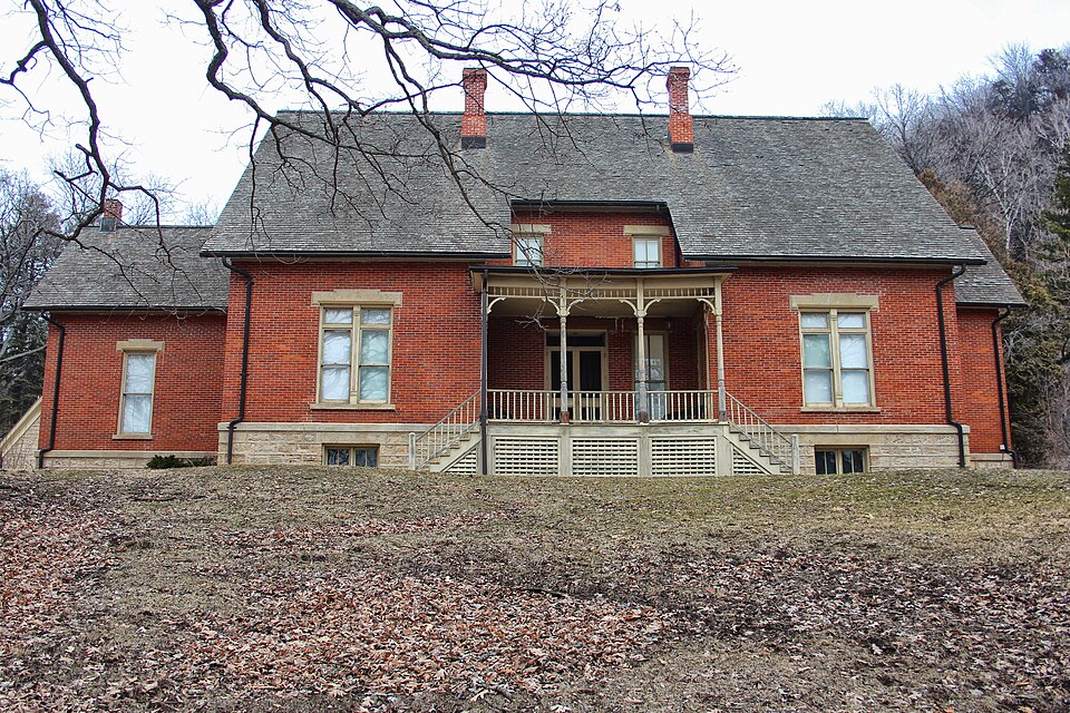
Built in 1868 (Gothic architecture). Listed on the National Register of Historic Places in 1970.
From the record
“Stonefield, located at 12195 County Road VV outside Cassville, Wisconsin, United States, was the 2,000-acre (800-hectare) estate of Wisconsin's first governor, Nelson Dewey. Much of the original estate has been separated into Nelson Dewey State Park and the Stonefield historic site, an expansive museum operated by the Wisconsin Historical Society.”
Wikipedia article Stonefield (Wisconsin), CC BY-SA 4.0.
One of 36 National Register listings published here for Grant County · listed in 1970 · category: Site · built in 1868, Gothic architecture.
National Register reference number.70000034- the number the National Park Service assigned this property when it was listed, and the key its nomination file is catalogued under at the National Archives.
The ground it stands on
10,167 words
The chapter on Cassville Town in History of Grant County, Wisconsin, published 1881 names Cassville. This is what it says, exactly as the scans read.
The first mention made of the present site of Cassville is by Mr. Shaw, a boatman on the Mississippi, who stopped at this point to bargain for a freight of lead ore on his trips down the river between 1816 and 1820. It would seem from this that there were habitations here at that time of French and Indians, but, as Shaw was obliged to go to Fever River for his lading, the probabilities are equally strong that no mining that could be dignified by the name was done here at that time. The next few years the place was undoubtedly deserted, as Mr. Thomas Hymer, as related by Mr. James Grushong, stopped at Cassville for some time in 1824, on his return from a trip to tho Selkirk Settlement, occupying a deserted cabin, there being no other occupants there at that time. The first signs of settlement came in 1827. Mr. Orris McCartney in his recollections, says : The first furnace was built at Cassville by Judge Sawyer ; Tom G. Hawley built the first house at the same time. The next link in the chain of evidence is furnished by Mr. Levi Gilbert, who came to Cassville in 1827, and states that Judge Sawyer erected his furnace that year, and " was to give a free Fourth of July dinner, but hearing of Indian troubles decamped July 3." These statements place the probable date of settlement in that year.
The following year quite a number of new ones came in, among them Orris McCartney and Alexander Ramsay ; Henry Hodges and Thomas Shanley are also reported as coming this year. Those who came, however, did not remain long at this time with the exception of Mr. Ramsey. Between this date and 1831, but very little is known of the young settlement. In the lastnamed year, Maj. Glendower M. Price arrived at the little settlement with his young bride, and bringing with him an extensive line of goods, with which he opened the first store in Cassville, in a building on the bank of the river standing on the present site of Grimm's warehouse. The log dwelling house of Maj. Price stood on the ground now occupied by Geyer's warehouse, while between them stood afterward the "block-house" that served as a place of refuge for so many early settlers during the troubles of 1832.
Regional context, not property-specific
evidence. The
federal wildfire occurrence database
lists 7 fires within 5 miles of Stonefield
between 2008 and 2018, burning about 201 acres in total. None started naturally. 1 was recorded as arson.
Distance is straight-line from the map coordinates, so a fire counted
here may appear on a neighbouring settlement's page as well.
Reported cause
Fires
Missing data/not specified/undetermined
6
Arson/incendiarism
1
The most recent of
them, most recent first, with the day each was reported and the service
that recorded it.
Date
Cause
Size
Reported by
Name on the report
1 May 2015
Missing data/not specified/undetermined
7.0 acres
McGregor District, Upper Mississippi River Complex
TURKEY BOTTOMS
28 April 2018
Missing data/not specified/undetermined
165 acres
Port Louisa National Wildlife Refuge
TURKEY RIVER
16 April 2008
Arson/incendiarism
8.5 acres
McGregor District, Upper Mississippi River Complex
TURKEY RIVER ARSON
4 March 2009
Missing data/not specified/undetermined
under an acre
Iowa Department of Natural Resources
not named
23 March 2017
Missing data/not specified/undetermined
5.0 acres
McGregor District, Upper Mississippi River Complex
TURKEY RIVER BOTTOMS WF
19 March 2011
Missing data/not specified/undetermined
2.0 acres
Iowa Department of Natural Resources
37649 ORANGE AVE, GUTTENBERG, IA
27 February 2016
Missing data/not specified/undetermined
13 acres
McGregor District, Upper Mississippi River Complex
Regional context, not property-specific
evidence. The federal mineral resources record lists
11 workings within 5 miles of Stonefield: 9 past producers, 1 unknown, 1 producer.
1 still produces. What was taken out: Stone, Crushed/Broken, Lead, Phosphorus-Phosphates, Lead, Zinc. Distance is straight-line from the
map coordinates, so a quarry counted here may appear on a neighbouring
settlement's page as well.
Regional context, not property-specific
evidence. The National Weather Service names
Cassville, the town this property stands in, in 25 storm reports between 1994 and 2024: 12 thunderstorm wind, 10 hail, 2 flash flood, 1 flood.
The reports record 1 death. Each account below is quoted exactly as the forecast office
filed it, from the NOAA Storm Events Database, and each date
opens the federal record of that event.
A major flash flood hit Grant County during the afternoon of June 12th impacting the communities of Lancaster, Potosi, Tennyson, Ellenboro, and other rural areas. Numerous rescues were performed from people trapped in cars, especially in the Potosi area where terrain enhanced the runoff from repeat thunderstorms. Several homes on Hippie Hollow Road in Potosi Township were destroyed along with damage to as many as 600 homes elsewhere in the region. Many highways and county roads suffered flood damage including major bridge and road infrastructure.
Trees, power lines and a barn were blown down in Cassville. A hangar at the municipal airport was damaged and a fabric covered plane that was inside the hangar was damaged extensively. Downed trees briefly blocked the Burlington Northern Santa Fe railroad tracks. Hundreds of trees were reported to have been blown down across town and several homes near the airport were damaged by the fallen trees.
Flooding continued in many areas of southwest Wisconsin during the evening of June 12th, especially on the Platte and Grant Rivers where rises of 4 feet an hour were reported. About 50 locations on Grant County roads were closed at one point due to flood waters and damage to infrastructure. Emergency Operation Centers and shelters were opened. A state of emergency was declared for the county.
No historic map-sheet match is published
for this property yet. That does not mean no map exists. This record needs
a coordinate-quality review before it can be joined to a sheet boundary.
Browse the county's mapped places while that work is
pending.
Listed places nearby
1 within 8 miles
Other National Register properties close
enough to walk or drive between, ordered by distance from this one. Both
positions come from the same geocoding pass that matched these properties
to their map sheets.
Listing record. National Park Service National Register of Historic Places, listed-properties dataset, current to 2026-05-22.
Map join. Address geocoded through the United States Census geocoder, then tested against the published boundary of every sheet in the USGS Historical Topographic Map Collection.
How this page is made. Listing fields come from federal records; map-sheet coverage is a labelled coordinate-to-boundary calculation, not a source-field claim.
Wildfire. Short, Karen C. 2022. Spatial wildfire occurrence data for the United States, 1992-2020 [FPA_FOD_20221014]. 6th Edition. Fort Collins, CO: Forest Service Research Data Archive. https://doi.org/10.2737/RDS-2013-0009.6 Collected with United States Government funding and usable without additional permissions or fees.
Mines and quarries. USGS Mineral Resources Data System (MRDS) https://mrdata.usgs.gov/mrds/ A work of the United States government, no copyright under 17 U.S.C. 105.
Storms. NOAA National Centers for Environmental Information, Storm Events Database https://www.ncei.noaa.gov/stormevents/ A work of the United States government, no copyright under 17 U.S.C. 105. Narratives are quoted verbatim from the National Weather Service report and are not edited or summarised.
 Block