BlockBefore
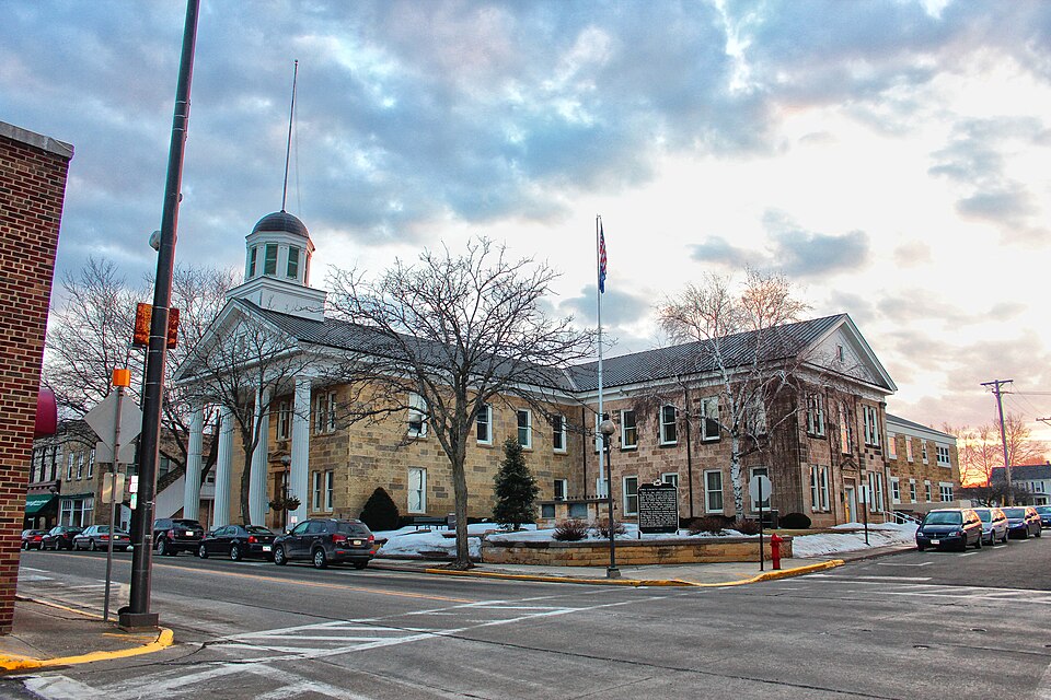
Photograph of Iowa County Courthouse
Photograph by Tgkrause, CC BY-SA 3.0. Via Wikimedia Commons.

Iowa County Courthouse

Built in 1859 (Greek Revival architecture). Listed on the National Register of Historic Places in 1972.

From the record

“The Iowa County Courthouse is a stone courthouse in Dodgeville, Wisconsin. Built by Cornish immigrants in 1859, it is the oldest courthouse still in use in Wisconsin.”

Wikipedia article Iowa County Courthouse (Wisconsin), CC BY-SA 4.0.

One of 30 National Register listings published here for Iowa County · listed in 1972 · category: Building · built in 1859, Greek Revival architecture.

Sources: the Wikipedia article · the case file at the National Archives · the National Register database, National Park Service

The listing

  • What is counted as historic. The nomination lists 1 building as contributing to the listing.
  • Address. NW corner of Iowa and Chapel Sts., Dodgeville, 53533
  • When was it listed? February 1972
  • Category. building
  • City. Dodgeville city
  • When was it built? 1859
  • Architectural style. Greek Revival architecture
  • National Register reference number. 72000053 - the number the National Park Service assigned this property when it was listed, and the key its nomination file is catalogued under at the National Archives.

The ground it stands on

27,097 words

The chapter on Dodgeville City in History of Iowa County, Wisconsin, Containing an Account of Its Settlement, Growth, Development and Resources...biographical Sketches.., published 1881 names Dodgeville. This is what it says, exactly as the scans read.

Dvdgeville Ranyers, Company C, TInrty-first Infantry. - The Thirty-first Regiment was principally recruited in the summer of 1862. The first rendezvous was held in September at Prairie du Chien, where, on the 9th of October, the recruits were mustered in under Col. L E. Messmore. One of the si.x companies mustered, C, or Dodgeville Rangers, was recruited in the town of Dodgeville. After lying in camp until the 14th of November, the regiment was divided, three companies going to Madison to take charge of the camps for drafted men. From there they were moved to Camp Jlitcliell, where the other companies had gone, and where, on the 13th of January, the remaining four companies were mustered in. On the 1st of March, 1863, the regiment was moved via Cairo, 111., to Columbus, Ky., where it was assigned to the Sixteenth Army Corps at Camp Halleck. While here, they were engaged in raiding, reconnoitering and guarding at different adjacent points. From Columbus, they proceeded via Caira and Louisville to Nashville, Tenn., in September, and remained there until October, when they moved to La Vergne, and thence to Murfreesboro. Soon after. Company B was detached and stationed at Stone River Crossing, where it remained until April, 1864, doing guard duty ; then joined the regiment at Murfreesboro. Soon after, the regiment was assigned to the Second Army Corps, and was divided into detachments, and placed on guard duty along the line of the railroad from Tullahoma to Murfreesboro. A mounted detachment under Lieut. Beattie did excellent service in Middle Tennessee from March to June. In June, the entire regiment was transferred to Nashville, Tenn., and placed on provost duty. On the 16th of July, 1864, they were ordered to Atlanta, where they arrived on the 21st of July, and took a position in the trenches, and where they were constantly under fire and engaged in fatigue duty until the evacuation by the enemy. Subsequently, thej' were engaged in foraging and garrison duty, until the 15th of November, when, with the Second Corps, they started and went through to the sea with Sherman. When within nine miles of Savannah, the regiment had to struggle through a terrible swamp, under heavy fire. However, it, in company with an Ohio regiment, captured the rebel camp and equipments, for which exploit they received the encomiums of the entire command. Eventually, the Thirty-first participated in the engagements at Chesterfield, S. C, March 1, 1865. At Averysboro, S. C, on the 16th of March. At Bentonville March 19, wiiere the regiment did distinguished service, helping to sustain five heavy charges, and losing sixty men. Thence they marched to Goldsboro and Raleigh, where they encamped. On the 3d of April, they started for home, stopping at Alexandria, Va., to engage in a grand review. May 20. Arriving at Louisville, Companies B and C were mustered out, June 20 ; reached Madison the 23d, and, on the 8th of July, were paid off and disbanded.

Passage source: History of Iowa County, Wisconsin, Containing an Account of Its Settlement, Growth, Development and Resources...biographical Sketches.., published 1881.

This thriving village, now the county seat of Iowa County, is, in some respects, the most notable point in the county, and, indeed, in the entire lead-mining region of Wisconsin. Not because of its having preceded all others, but rather on account of its prominence in 1827 and 1828, as the principal mining point on the extreme frontier, and as having been the especial protege of Gov. Henry Dodge, after whom it was named. The annals of the early days are filled with the exploits of this noted man, around whom and Dodgeville the chief events and experiences connected with the miners who first came to this county, were centered. He was preeminently the prophet, law-giver and founder of this place not only, but was one of the figureheads in the history of the State that the sons and daughters of modern life love to contemplate. The reckless bravado of the early miners, and the no less unrestrained ruthlessness of the aboriginal inhabitants, which operated disastrously in the extreme for them in many instances, were doubtless the anterior means which opened the way to the present fruitful development.

Passage source: History of Iowa County, Wisconsin, Containing an Account of Its Settlement, Growth, Development and Resources...biographical Sketches.., published 1881.

Machine-read from a century-old scan, so expect the errors a machine makes: misspelled names, dropped words, stray characters.

Read the whole chapter on Dodgeville City - 27,097 words on its settlement, mills, schools and churches.

Fires near this property

14 since 1995

Regional context, not property-specific evidence. The federal wildfire occurrence database lists 14 fires within 5 miles of Iowa County Courthouse between 1995 and 2020, burning about 209 acres in total. None started naturally. 1 was recorded as arson. Distance is straight-line from the map coordinates, so a fire counted here may appear on a neighbouring settlement's page as well.

Reported cause Fires
Missing data/not specified/undetermined7
Debris and open burning4
Power generation/transmission/distribution2
Arson/incendiarism1

The most recent of them, most recent first, with the day each was reported and the service that recorded it.

DateCause SizeReported by Name on the report
25 August 2003Missing data/not specified/undetermined32 acresWisconsin Department of Natural Resourcesnot named
17 May 2018Power generation/transmission/distribution1.0 acresWisconsin Department of Natural Resources2018069
11 May 1996Missing data/not specified/undetermined1.8 acresWisconsin Department of Natural Resourcesnot named
1 May 2018Power generation/transmission/distribution9.0 acresWisconsin Department of Natural Resources2018067
3 April 1995Missing data/not specified/undetermined10 acresWisconsin Department of Natural Resourcesnot named
23 April 2018Debris and open burningunder an acreWisconsin Department of Natural Resources6761
23 April 2018Debris and open burning4.0 acresWisconsin Department of Natural Resources2018061
22 April 2018Debris and open burning3.0 acresWisconsin Department of Natural Resources2018060

Every fire recorded in Iowa County

Mines and quarries near this property

10 of 112 shown

Regional context, not property-specific evidence. The federal mineral resources record lists 112 workings within 5 miles of Iowa County Courthouse: 89 past producers, 17 unknowns, 4 producers, 2 occurrences. 4 still produce. What was taken out: Lead, Zinc, Lead, Zinc, Stone, Crushed/Broken. Distance is straight-line from the map coordinates, so a quarry counted here may appear on a neighbouring settlement's page as well.

Where SiteCommodity StatusRecorded
Dodgeville No.2 and 3 MinesZinc, LeadPast Producer1945
Turnell QuarryStoneUnknown
Unnamed Prospect Near DodgevilleCopperOccurrence
Burgess QuarryStone, Crushed/BrokenProducer
Iowa County QuarriesStone, Crushed/BrokenProducer
Kurth QuarryStone, Crushed/BrokenPast Producer
Potterton QuarryStone, Crushed/BrokenProducer
Watson-Dodgeville QuarryStone, Crushed/BrokenProducer
Dodgeville No.1 Group of MinesLead, ZincPast Producer1924, 1926

Every working recorded in Iowa County

Storms near this property

52 since 1994

Regional context, not property-specific evidence. The National Weather Service names Dodgeville, the town this property stands in, in 52 storm reports between 1994 and 2026: 27 thunderstorm wind, 17 hail, 3 heavy rain, 2 funnel cloud. No death or injury is recorded in these reports. Each account below is quoted exactly as the forecast office filed it, from the NOAA Storm Events Database, and each date opens the federal record of that event.

WhenEvent Place namedHarm What the report says
April 2006HailDodgeville$4,440,000no account filed
September 2011Thunderstorm WindDodgeville$100,000Law enforcement officials reported damage from severe thunderstorm wind gusts estimated at 70 knots (80 mph) in a 5-mile wide swath from southeast of Dodgeville to northeast of Hollandale. The damaging winds destroyed a cattle shed and caused minor damage to a barn. The winds damaged several corn fields on East Lawinger Road southeast of Dodgeville. A grain bin was knocked off its foundation and destroyed, and a corn field was flattened northeast of Hollandale. Numerous trees and power lines were knocked down by the powerful winds.
July 2025Tornado (EF1)Dodgeville$85,000An EF-1 rated tornado developed near the Farm and Fleet in Dodgeville, first moving northeast through a corn field. The tornado then continued to the northeast, impacting numerous trees and one outbuilding. The strongest damage occurred off of County Road ZZ, where numerous large, healthy hardwood trees were uprooted. The tornado ended near Knobs Road, just west of County Road H.
April 2008LightningDodgeville$75,000LIghtning struck a communications tower belonging to the Iowa County Sheriff Department. Radios and computer equipment were damaged. The time of this event is estimated, since the newspaper article indicated that the event occurred during the morning hours.
June 2009Thunderstorm WindDodgeville$50,000Many reports of toppled trees and damaged power-lines were received from within and near Dodgeville to a couple miles east of Mineral Point.
August 1996Thunderstorm WindDodgeville$18,000no account filed
July 2008Thunderstorm WindDodgeville$10,000Powerful thunderstorm winds toppled large trees, and knocked down large tree branches that brought down some power-lines.
June 2005Thunderstorm WindDodgeville$10,000Powerpoles down on Highway 18.
March 1998FloodDodgeville$10,000no account filed
July 1998Thunderstorm WindDodgeville$10,000no account filed
June 2024Thunderstorm WindDodgeville$5,000Several trees and power lines down in Dodgeville.
May 2024Thunderstorm WindDodgeville$5,000Multiple trees and branches down in the Dodgeville area.
June 1994Thunderstorm WindDodgeville$5,000A tornado traveled easterly 5 miles across Grant county from 1 mile northeast of Patch Grove to 1 mile south of Mt. Hope. The tornado ripped a roof from a large hay barn, threw over a grain elevator, damaged several homes and leveled numerous trees and power lines. A severe thunderstorm dropped golfball hail and developed intense winds which downed power lines just west of Dodgeville (Iowa county).
May 2017Thunderstorm WindDodgeville$4,000Several trees and limbs down including power lines.
September 2013Thunderstorm WindDodgeville$3,000Trees down.
June 1998Thunderstorm WindDodgeville$3,000no account filed
June 1997Thunderstorm WindDodgeville$3,000no account filed
July 2020Thunderstorm WindDodgeville$2,000Several trees down in Dodgeville.
May 2024Thunderstorm WindDodgeville$1,000Shed roof blown off.
May 1999Thunderstorm WindDodgeville$1,000no account filed
June 1997Thunderstorm WindDodgeville$1,000no account filed
March 2025Thunderstorm WindDodgeville-Measured at Mesonet station AP090 which is 0.4 miles west-southwest of Dodgeville.
July 2019Thunderstorm WindDodgeville-An estimated wind gust of 60 mph.
July 2012Thunderstorm WindDodgeville-Law enforcement officials reported trees and power lines blown down by severe thunderstorm wind gusts estimated at 65 mph (56 knots).
August 2010Thunderstorm WindDodgeville-Sheriff deputies reported large trees were blown down by thunderstorm wind gusts estimated up to 56 knots (65 mph).
June 2009Thunderstorm WindDodgeville-An entire grove of trees was toppled.
June 1994Thunderstorm WindDodgeville-A severe thunderstorm with winds gusting to 60 mph hit Dodgeville (Iowa county).
April 2026HailDodgeville-no account filed
April 2025HailDodgeville-no account filed
May 2024HailDodgeville-no account filed
June 2011Funnel CloudDodgeville-no account filed
June 2009HailDodgeville-no account filed
May 2006HailDodgeville-no account filed
June 2005Thunderstorm WindDodgeville-no account filed
November 2003Heavy RainDodgeville-no account filed
April 2003Heavy RainDodgeville-no account filed
May 2003HailDodgeville-no account filed
July 2003HailDodgeville-no account filed
April 2002Thunderstorm WindDodgeville-no account filed
July 2002Thunderstorm WindDodgeville-no account filed
September 2001Heavy RainDodgeville-no account filed
August 2000Funnel CloudDodgeville-no account filed
June 1999HailDodgeville-no account filed

Every storm recorded in Iowa County

Map coverage status

No historic map-sheet match is published for this property yet. That does not mean no map exists. This record needs a coordinate-quality review before it can be joined to a sheet boundary. Browse the county's mapped places while that work is pending.

Listed places nearby

6 within 8 miles

Other National Register properties close enough to walk or drive between, ordered by distance from this one. Both positions come from the same geocoding pass that matched these properties to their map sheets.

Photograph PropertyDistance Listed
Iowa Street Historic Districtunder 500 feet1996
Dodge Mining Camp Cabin0.2 miles2005
Old Rock School0.5 miles1978
David J. and Maggie Jones House0.7 miles1994
Plum Grove Primitive Methodist Church5.6 miles1995
Mineral Point Historic District7.1 miles1971

Sources for this property

National Archives recordThe nomination case file for reference 72000053 in Record Group 79.
Wikipedia articleCommunity-written account of this property, licensed CC BY-SA.
Iowa CountyAll 30 listed properties in this county.

Provenance

  • Listing record. National Park Service National Register of Historic Places, listed-properties dataset, current to 2026-05-22.
  • Map join. Address geocoded through the United States Census geocoder, then tested against the published boundary of every sheet in the USGS Historical Topographic Map Collection.
  • How this page is made. Listing fields come from federal records; map-sheet coverage is a labelled coordinate-to-boundary calculation, not a source-field claim.
  • Wildfire. Short, Karen C. 2022. Spatial wildfire occurrence data for the United States, 1992-2020 [FPA_FOD_20221014]. 6th Edition. Fort Collins, CO: Forest Service Research Data Archive. https://doi.org/10.2737/RDS-2013-0009.6 Collected with United States Government funding and usable without additional permissions or fees.
  • Mines and quarries. USGS Mineral Resources Data System (MRDS) https://mrdata.usgs.gov/mrds/ A work of the United States government, no copyright under 17 U.S.C. 105.
  • Storms. NOAA National Centers for Environmental Information, Storm Events Database https://www.ncei.noaa.gov/stormevents/ A work of the United States government, no copyright under 17 U.S.C. 105. Narratives are quoted verbatim from the National Weather Service report and are not edited or summarised.