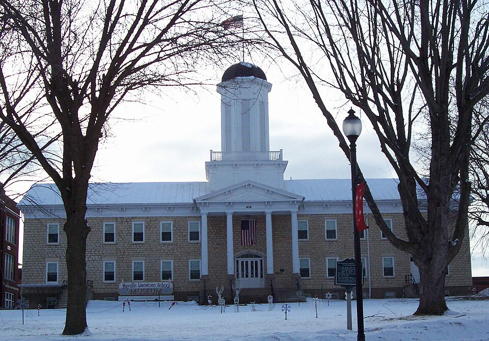
Built in 1858 (Greek Revival architecture). Listed on the National Register of Historic Places in 1976.
From the record
One of 36 National Register listings published here for Dodge County · listed in 1976 · category: Building · built in 1858, Greek Revival architecture.
National Register reference number.76000057- the number the National Park Service assigned this property when it was listed, and the key its nomination file is catalogued under at the National Archives.
What happened here
An account from the chapter on Mayville city. The inset identifies its exact
source book and publication year.
The history of Beaver Dam is comparatively free from crime. In September, 1858, occurred, probably, the only deliberate murder that the local press has been called upon to chronicle. James M. Conklin, a disreputable character, and Simon Malone, having been engaged in a protracted family quarrel over the use of a well located on the line dividing their respective premises, the feud culminated in Conklin's insulting, and ill-treating members of Malone's family, after which he proceeded to a saloon on Front street, and, while standing at the bar drinking, having remarked in the presence of Malone that he would " drive the red-mouthed Irishman out of town,' the latter deliberately drew a revolver and shot Conklin in the back, the ball passing through his lungs, resulting in death within the next forty-eight hours.
When it became necessary to give the place a name, many were suggested, but none seemed to meet the approval of the majority. Finally, one suggested that it be called Mayville, in honor of Uncle May, as he was familiai'ly called, one of the proprietors. The name was unanimously adopted.
By a large number of American people, a place is judged by its school facilities. If they are good, the place is to be commended ; if imperfect, it is to be condemned. Mayville will stand tlie test of righteous judgment. The first school was in the winter of 1847, in the cabin of a private family, and in the year following a log schoolhouse was built and school held therein. As the demands of the country increased, other arrangements were ma.de, until finally, a few years since, the village erected one of the finest and most substantial school buildings in the county - one in which her citizens take a just pride. In this the English language is taught exclusively. For their own convenience, and to keep up a knowledge of the mother tongue, the Germans support from private funds a good school.
Regional context, not property-specific
evidence. The
federal wildfire occurrence database
lists 14 fires within 5 miles of White Limestone School
between 1996 and 2020, burning about 940 acres in total. 2 started naturally. 1 was recorded as arson.
Distance is straight-line from the map coordinates, so a fire counted
here may appear on a neighbouring settlement's page as well.
Reported cause
Fires
Missing data/not specified/undetermined
5
Debris and open burning
4
Natural
2
Arson/incendiarism
1
Equipment and vehicle use
1
Recreation and ceremony
1
The most recent of
them, most recent first, with the day each was reported and the service
that recorded it.
Regional context, not property-specific
evidence. The federal mineral resources record lists
6 workings within 5 miles of White Limestone School: 4 past producers, 2 producers.
2 still produce. What was taken out: Sand and Gravel, Construction, Iron, Copper, Lead, Iron, Calcium. Distance is straight-line from the
map coordinates, so a quarry counted here may appear on a neighbouring
settlement's page as well.
Regional context, not property-specific
evidence. The National Weather Service names
Mayville, the town this property stands in, in 19 storm reports between 1995 and 2025: 8 thunderstorm wind, 6 hail, 2 lightning, 2 flood.
No death or injury is recorded in these reports. Each account below is quoted exactly as the forecast office
filed it, from the NOAA Storm Events Database, and each date
opens the federal record of that event.
Lightning struck a barn on Morris Rd., resulting in a fire that destroyed the structure, as well as a 1994 vehicle parked inside. An adjacent small shed also had a small fire that was quickly extinguished.
Numerous trees and power lines down throughout Mayville. Some trees uprooted, others snapped. A large tree on a house and trees down on vehicles. City Works Department using front end loaders to clear the streets from fallen trees.
Several inches of rain during the overnight and morning hours resulted in flooding around St. John's Lutheran School and Parkview Elementary School. The schools were evacuated and sandbagging was necessary. Nearby highway 28 and a few other road closures occurred due to deep water.
Law enforcement officials reported a few trees and power lines downed by thunderstorm wind gusts estimated at 70 mph (61 knots) along a path from Mayville to Brownsville.
This weak tornado lasted less than a minute and resulted in only broken tree limbs. It spun up southwest of the intersection of Polk Road and Madison Rd. The starting and ending locations, with respect to lat/long pairs of numbers, were 43.46927/-88.52612 and 43.47016/-88.52494. DI#28 (TS), DOD2. Wind speed estimated at about 75 mph. Average path width about was about 10 yards.
No historic map-sheet match is published
for this property yet. That does not mean no map exists. This record needs
a coordinate-quality review before it can be joined to a sheet boundary.
Browse the county's mapped places while that work is
pending.
Listed places nearby
6 within 8 miles
Other National Register properties close
enough to walk or drive between, ordered by distance from this one. Both
positions come from the same geocoding pass that matched these properties
to their map sheets.
Listing record. National Park Service National Register of Historic Places, listed-properties dataset, current to 2026-05-22.
Map join. Address geocoded through the United States Census geocoder, then tested against the published boundary of every sheet in the USGS Historical Topographic Map Collection.
How this page is made. Listing fields come from federal records; map-sheet coverage is a labelled coordinate-to-boundary calculation, not a source-field claim.
Wildfire. Short, Karen C. 2022. Spatial wildfire occurrence data for the United States, 1992-2020 [FPA_FOD_20221014]. 6th Edition. Fort Collins, CO: Forest Service Research Data Archive. https://doi.org/10.2737/RDS-2013-0009.6 Collected with United States Government funding and usable without additional permissions or fees.
Mines and quarries. USGS Mineral Resources Data System (MRDS) https://mrdata.usgs.gov/mrds/ A work of the United States government, no copyright under 17 U.S.C. 105.
Storms. NOAA National Centers for Environmental Information, Storm Events Database https://www.ncei.noaa.gov/stormevents/ A work of the United States government, no copyright under 17 U.S.C. 105. Narratives are quoted verbatim from the National Weather Service report and are not edited or summarised.
 Block