BlockBefore
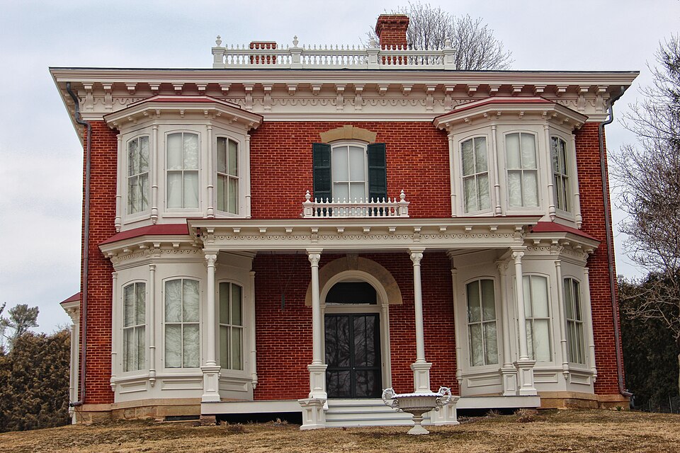
Photograph of James Ballantine House
Photograph by Tgkrause, CC BY-SA 3.0. Via Wikimedia Commons.

James Ballantine House

Built in 1877 (Italianate architecture). Listed on the National Register of Historic Places in 1976.

From the record

One of 36 National Register listings published here for Grant County · listed in 1976 · category: Building · built in 1877, Italianate architecture.

Sources: the case file at the National Archives · the National Register database, National Park Service · the Wikipedia article

The listing

  • What is counted as historic. The nomination lists 2 buildingss as contributing to the listing.
  • Listed as. Ballantine, James, House - the National Register files a house under its owner's surname.
  • Address. 720 North 4th Street, Bloomington, 53804
  • When was it listed? June 1976
  • Category. building
  • Village. Bloomington village
  • When was it built? 1877
  • Architectural style. Italianate architecture
  • National Register reference number. 76000062 - the number the National Park Service assigned this property when it was listed, and the key its nomination file is catalogued under at the National Archives.

What happened here

An account from the chapter on Bloomington village. The inset identifies its exact source book and publication year.

From History of Grant County Wisconsin, published 1900 - Bloomington Village

The Great Fire

For nearly forty-five years Blooeqiugton existed as a village with¬ out a house being burned - a remarkable record. The Finn building caught fire three times, but each tune the .fire was discovered in time to he extinguished without serious damage. But at last, on the night of March 22, 1897, what everybody had been expecting for thirty years happened, and two-thirds of the business part of the vil¬ lage was swept away in .a night.

Read the rest of this passage

The ground it stands on

5,431 words

The chapter on Bloomington Village in History of Grant County Wisconsin, published 1900 names Bloomington. This is what it says, exactly as the scans read.

Bnt while the village was thus flourishing, trouble befell its found¬ er, D. W. Taft. Getting into financial difficulties, the mill property fell into the hands of the mortgagee, Cyrus Sargent, who soon after transferred it to Woodhouse & Thomas. A good many of the villagers had become unfriendly to Mr. Taft and through their influence the name of the village, township, and post-office was changed to Bloom¬ ington in 1867. The change in the name of the town and the village was made by the legislature. Before this the village had been divided into factions on the academy matter, and now one faction espoused the cause of Taft and Tafton and the others that of Bloomington. The County Board was petitioned to change the name back to Tafton, and at its annual session in November, 1867, the Board ordered a special election to determine the matter ; bnt if the town neglected to hold such election, then the name should be changed to Tafton. Such election was held and the name Bloomington received 143 votes and the name Tafton 96 votes.

Passage source: History of Grant County Wisconsin, published 1900.

Bloomington has not suffered as many of these as most towns. The fint one was an explosion in the store of Benham & Osborne, in February, 1857. Mr. J. F. Benham was about to measure out some machine oil and took a can which he supposed to contain oil and placed it on the stove to warm it. It proved to contain powder, which exploded. The front of the store was blown out and the build¬ ing otherwise damaged. Mr. Benham was knocked senseless, and was badly burned and the sight of one eye destroyed. The next accident was less serious. A donation party was held in the building just across the street from the hotel January 31, 1857. The floor on which the party was assembled gave way, precipitating them all into the basement, where the supper table was set. The supper was worse damaged than any of the party. One lady put her foot into a large piece of butter whose elaborate molding had called forth a good deal of admiration before the accident, and another landed (if landed is the appropriate word) in a wash-boiler full of oyster soup.

Passage source: History of Grant County Wisconsin, published 1900.

Machine-read from a century-old scan, so expect the errors a machine makes: misspelled names, dropped words, stray characters.

Read the whole chapter on Bloomington Village - 5,431 words on its settlement, mills, schools and churches.

Fires near this property

4 since 2018

Regional context, not property-specific evidence. The federal wildfire occurrence database lists 4 fires within 5 miles of James Ballantine House between 2018 and 2020, burning about 2 acres in total. None started naturally. 1 was recorded as arson. Distance is straight-line from the map coordinates, so a fire counted here may appear on a neighbouring settlement's page as well.

Reported cause Fires
Missing data/not specified/undetermined2
Arson/incendiarism1
Debris and open burning1

The most recent of them, most recent first, with the day each was reported and the service that recorded it.

DateCause SizeReported by Name on the report
18 June 2020Missing data/not specified/undeterminedunder an acreWisconsin Department of Natural Resources12A2020
28 March 2019Arson/incendiarismunder an acreWisconsin Department of Natural Resources10A2019
18 March 2018Debris and open burning1.0 acresWisconsin Department of Natural Resources5
5 February 2019Missing data/not specified/undetermined1.0 acresWisconsin Department of Natural Resources01A2019

Every fire recorded in Grant County

Mines and quarries near this property

5 within 5 miles

Regional context, not property-specific evidence. The federal mineral resources record lists 5 workings within 5 miles of James Ballantine House: 2 unknowns, 2 past producers, 1 producer. 1 still produces. What was taken out: Stone, Crushed/Broken, Stone. Distance is straight-line from the map coordinates, so a quarry counted here may appear on a neighbouring settlement's page as well.

Where SiteCommodity StatusRecorded
Finn QuarryStoneUnknown
Kirschbaum QuarryStoneUnknown
Charlie White QuarryStone, Crushed/BrokenProducer
Ulehoven QuarryStone, Crushed/BrokenPast Producer
Zenz QuarryStone, Crushed/BrokenPast Producer

Every working recorded in Grant County

Storms near this property

11 since 1999

Regional context, not property-specific evidence. The National Weather Service names Bloomington, the town this property stands in, in 11 storm reports between 1999 and 2022: 4 thunderstorm wind, 3 hail, 2 flash flood, 1 lightning. The reports record 1 death. Each account below is quoted exactly as the forecast office filed it, from the NOAA Storm Events Database, and each date opens the federal record of that event.

WhenEvent Place namedHarm What the report says
August 2001LightningBloomington1 killedno account filed
September 2019Flash FloodBloomington$900,000Runoff from heavy rains caused flash flooding to occur across the northwest portion of Grant County. Nearly every township road was closed because of flood damage across Wyalusing, Millville and Woodman townships. Roads were also closed in and near Fennimore. Water over the road, debris on the road and mudslides affected U.S. Highway 61 for about 5 miles south of Boscobel.
May 2001Thunderstorm WindBloomington$8,000no account filed
June 2020Thunderstorm WindBloomington$5,000Trees and power lines were blown down near Bloomington.
August 2007Thunderstorm WindBloomington$500Trees were blown down onto Highway 35 and blocked traffic.
July 2022Funnel CloudBloomington-A funnel cloud was sighted near Bloomington.
August 2020Thunderstorm WindBloomington-An estimated 60 mph wind gust occurred in Bloomington.
July 2016Flash FloodBloomington-Locally heavy rains caused most creeks in and near Bloomington to go out of their banks.
June 2015HailBloomington-no account filed
June 2011HailBloomington-no account filed
May 1999HailBloomington-no account filed

Every storm recorded in Grant County

Map coverage status

No historic map-sheet match is published for this property yet. That does not mean no map exists. This record needs a coordinate-quality review before it can be joined to a sheet boundary. Browse the county's mapped places while that work is pending.

Sources for this property

National Archives recordThe nomination case file for reference 76000062 in Record Group 79.
Wikipedia articleCommunity-written account of this property, licensed CC BY-SA.
Grant CountyAll 36 listed properties in this county.

Provenance

  • Listing record. National Park Service National Register of Historic Places, listed-properties dataset, current to 2026-05-22.
  • Map join. Address geocoded through the United States Census geocoder, then tested against the published boundary of every sheet in the USGS Historical Topographic Map Collection.
  • How this page is made. Listing fields come from federal records; map-sheet coverage is a labelled coordinate-to-boundary calculation, not a source-field claim.
  • Wildfire. Short, Karen C. 2022. Spatial wildfire occurrence data for the United States, 1992-2020 [FPA_FOD_20221014]. 6th Edition. Fort Collins, CO: Forest Service Research Data Archive. https://doi.org/10.2737/RDS-2013-0009.6 Collected with United States Government funding and usable without additional permissions or fees.
  • Mines and quarries. USGS Mineral Resources Data System (MRDS) https://mrdata.usgs.gov/mrds/ A work of the United States government, no copyright under 17 U.S.C. 105.
  • Storms. NOAA National Centers for Environmental Information, Storm Events Database https://www.ncei.noaa.gov/stormevents/ A work of the United States government, no copyright under 17 U.S.C. 105. Narratives are quoted verbatim from the National Weather Service report and are not edited or summarised.