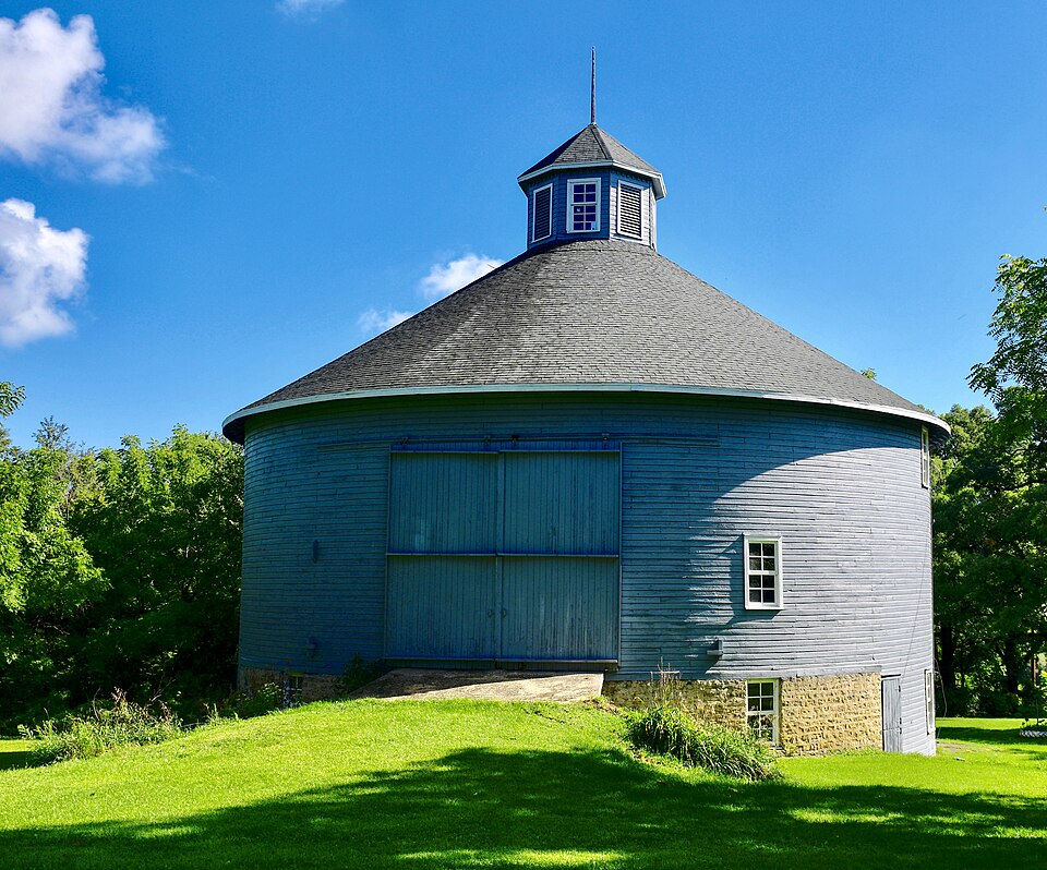
Built in 1892. Listed on the National Register of Historic Places in 1979.
From the record
“The Risum Round Barn near Orfordville, Wisconsin, United States, is a round barn that was built during 1890-1892. It was listed on the National Register of Historic Places (NRHP) in 1979.”
Wikipedia article Risum Round Barn, CC BY-SA 4.0.
One of 141 National Register listings published here for Rock County · listed in 1979 · category: Building · built in 1892.
National Register reference number.79000112- the number the National Park Service assigned this property when it was listed, and the key its nomination file is catalogued under at the National Archives.
W. F. CliARK, carriage-maker; P. 0. Orfordville; was born in New York in 1814; came to Wisconsin in 1844, and entered a quarter-section of land, which he farmed until 1869, and then went into his present business. He served as mechanic in the late war, in the 8th Tenn. Vol. Inf., Co. G, and took an active part in the battle of Nashville. In 1836, he married Miss Hannah Van Wagner; she was born in New York ; they have five children.
OliE P. OAABDEB, famer, Sec. 25 ; P. 0. Orfordville; born June 9, 1844, in Spring Valley Township, Bock Co., Wis. ; his father, P. H. Gaarder, came to America in 1843, located in Plymouth Township, and moved to Spring Valley in 1844 ; bought 240 acres of wild land, which he and his sons cleared and cultivated ; he died in 1875 ; 0. P. Gaarder bought 120 acres from his father in 1860 and has Since added more ; he now owns 260 acres and raises corn, oats, wheat, horses, cows, sheep, hogs and poultry ; selling pork and beef principally and making butter for the market. Married Miss Annie Husemon, of Newark Township, Feb. 20, 1868, and has five children - Nellie, born Jan. 30, 1869: Perry E., Aug. 5, 1871 ; Bertha, Nov. 23, 1873; Ida H., June 7, 1876 ; Herbert C, April 13, 1879^ He was Assessor for 1870 and 1871 ; Side Supeivisor for four years and is again for 1879 ; was Clerk of School District nine yeais ; is Treasurer School District for 1879; Pathmaster several times; is a member of Spring Valley Anti-Horse-Thief Afsociation ; was elected a Director of the Hecla Fire Insurance Company of Madison in 1876, and still holds that position. lie and his family are members of the Lutheran Church.
Regional context, not property-specific
evidence. The
federal wildfire occurrence database
lists 14 fires within 5 miles of Risum Round Barn
between 2009 and 2019, burning about 20 acres in total. None started naturally. 1 was recorded as arson.
Distance is straight-line from the map coordinates, so a fire counted
here may appear on a neighbouring settlement's page as well.
Reported cause
Fires
Debris and open burning
6
Missing data/not specified/undetermined
3
Smoking
2
Equipment and vehicle use
1
Power generation/transmission/distribution
1
Arson/incendiarism
1
The most recent of
them, most recent first, with the day each was reported and the service
that recorded it.
Regional context, not property-specific
evidence. The federal mineral resources record lists
6 workings within 5 miles of Risum Round Barn: 4 past producers, 1 producer, 1 unknown.
1 still produces. What was taken out: Stone, Crushed/Broken, Sand and Gravel, Construction, Stone. Distance is straight-line from the
map coordinates, so a quarry counted here may appear on a neighbouring
settlement's page as well.
Regional context, not property-specific
evidence. The National Weather Service names
Orfordville, the town this property stands in, in 41 storm reports between 1998 and 2023: 23 thunderstorm wind, 10 hail, 5 lightning, 2 funnel cloud.
No death or injury is recorded in these reports. Each account below is quoted exactly as the forecast office
filed it, from the NOAA Storm Events Database, and each date
opens the federal record of that event.
Heavy rains resulted in flash flooding across much of the northwest half of the county. Water depths on road surfaces reached 3 feet or more and there were gravel washouts. Two hundred thirty-nine homes had minor damage, 9 homes had major damage, and 26 were destroyed (total of $7.46 million for all home property losses). Fifty-four businesses had minor damage, and 24 had major damage (total business losses were about $810 thousand. Crops losses were estimated at $15 million). Public sector damage was about $10.3 million. There were several roads and bridges that sustained damage.
Law enforcement officials in Rock County reported trees and power lines down in a 23-mile wide swath from west northwest of Orfordville to northeast of Clinton due to damaging thunderstorm wind gusts estimated at 65 knots (75 mph). Corn crops, valued at $700,000, were also flattened. A home in downtown Janesville had a bedroom addition crushed when a tree fell on it. The winds also blew down a barn on Creek Road where it crosses Turtle Creek, as well as a giant 22-foot, 2,000 pound fiberglass pumpkin off of a 65-foot tall silo at Meyer's Farm Market north of Janesville.
Rock County Highway Department workers reported the intersection of State Highway 11 and State Highway 213 in Orfordville was closed due to trees and power lines downed by powerful thunderstorm winds that gusted to an estimated 75 mph (65 knots).
Law enforcement officials reported a few trees and power lines blown down by thunderstorm wind gusts estimated at 65 mph (56 knots) 5 miles west of Orfordville.
Powerful thunderstorms winds knocked down large trees. Several reports were received from this area from law enforcement officials and other trained spotters.
No historic map-sheet match is published
for this property yet. That does not mean no map exists. This record needs
a coordinate-quality review before it can be joined to a sheet boundary.
Browse the county's mapped places while that work is
pending.
Listed places nearby
6 within 8 miles
Other National Register properties close
enough to walk or drive between, ordered by distance from this one. Both
positions come from the same geocoding pass that matched these properties
to their map sheets.
Listing record. National Park Service National Register of Historic Places, listed-properties dataset, current to 2026-05-22.
Map join. Address geocoded through the United States Census geocoder, then tested against the published boundary of every sheet in the USGS Historical Topographic Map Collection.
How this page is made. Listing fields come from federal records; map-sheet coverage is a labelled coordinate-to-boundary calculation, not a source-field claim.
Wildfire. Short, Karen C. 2022. Spatial wildfire occurrence data for the United States, 1992-2020 [FPA_FOD_20221014]. 6th Edition. Fort Collins, CO: Forest Service Research Data Archive. https://doi.org/10.2737/RDS-2013-0009.6 Collected with United States Government funding and usable without additional permissions or fees.
Mines and quarries. USGS Mineral Resources Data System (MRDS) https://mrdata.usgs.gov/mrds/ A work of the United States government, no copyright under 17 U.S.C. 105.
Storms. NOAA National Centers for Environmental Information, Storm Events Database https://www.ncei.noaa.gov/stormevents/ A work of the United States government, no copyright under 17 U.S.C. 105. Narratives are quoted verbatim from the National Weather Service report and are not edited or summarised.
 Block