
BlockBefore
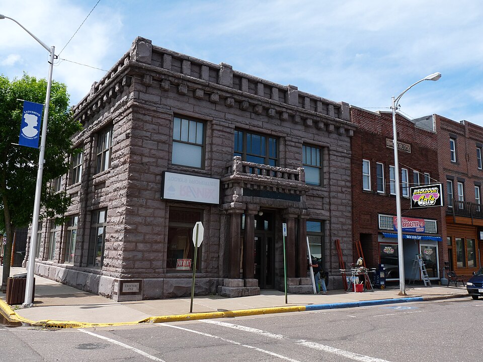
Photograph of State Bank of Ladysmith
Photograph by Jeff the quiet, CC0 1.0. Via Wikimedia Commons.

State Bank of Ladysmith

Built in 1912 (Neoclassical architecture). Listed on the National Register of Historic Places in 1980.

From the record

“The State Bank of Ladysmith is a historic bank building at 102 W. 2nd Street in Ladysmith, Wisconsin. The building was constructed in 1912 as a permanent home for the State Bank of Ladysmith.”

Wikipedia article State Bank of Ladysmith, CC BY-SA 4.0.

One of 3 National Register listings published here for Rusk County · listed in 1980 · category: Building · built in 1912, Neoclassical architecture.

Sources: the Wikipedia article · the case file at the National Archives · the National Register database, National Park Service

The listing

  • What is counted as historic. The nomination lists 1 building as contributing to the listing.
  • Address. 102 W. 2nd St., Ladysmith, 54848
  • When was it listed? January 1980
  • Category. building
  • City. Ladysmith city
  • When was it built? 1912
  • Architectural style. Neoclassical architecture
  • National Register reference number. 80000192 - the number the National Park Service assigned this property when it was listed, and the key its nomination file is catalogued under at the National Archives.

Fires near this property

120 since 1992

Regional context, not property-specific evidence. The federal wildfire occurrence database lists 120 fires within 5 miles of State Bank of Ladysmith between 1992 and 2020, burning about 65 acres in total. 1 started naturally. 13 were recorded as arson. Distance is straight-line from the map coordinates, so a fire counted here may appear on a neighbouring settlement's page as well.

Reported cause Fires
Debris and open burning41
Equipment and vehicle use27
Missing data/not specified/undetermined15
Arson/incendiarism13
Railroad operations and maintenance8
Smoking6
Recreation and ceremony4
Misuse of fire by a minor3
Natural1
Power generation/transmission/distribution1
Other causes1

The most recent of them, most recent first, with the day each was reported and the service that recorded it.

DateCause SizeReported by Name on the report
4 August 2006Debris and open burningunder an acreWisconsin Department of Natural Resourcesnot named
19 August 2019Misuse of fire by a minorunder an acreWisconsin Department of Natural ResourcesBELL SCHOOL
11 August 1992Missing data/not specified/undeterminedunder an acreWisconsin Department of Natural Resourcesnot named
7 July 2020Equipment and vehicle useunder an acreWisconsin Department of Natural ResourcesBELL SCHOOL
7 July 2018Equipment and vehicle useunder an acreWisconsin Department of Natural ResourcesDAM ROAD FIRE
30 July 1992Equipment and vehicle useunder an acreWisconsin Department of Natural Resourcesnot named
28 July 2012Debris and open burningunder an acreWisconsin Department of Natural ResourcesSHEEPRANCH
22 July 2015Equipment and vehicle useunder an acreWisconsin Department of Natural ResourcesHWY 8 DITCH

Every fire recorded in Rusk County

Mines and quarries near this property

10 of 18 shown

Regional context, not property-specific evidence. The federal mineral resources record lists 18 workings within 5 miles of State Bank of Ladysmith: 8 past producers, 4 occurrences, 4 producers, 1 unknown. 5 still produce. What was taken out: Sand and Gravel, Construction, Zinc, Copper, Gold, Silver, Gold, Copper. Distance is straight-line from the map coordinates, so a quarry counted here may appear on a neighbouring settlement's page as well.

Where SiteCommodity StatusRecorded
Eisenbrey DepositZinc, Copper, Gold, SilverUnknown1973
Flambeau MineCopper, Silver, Gold, Zinc, LeadProducer1968, 1993
Flambeau/Ladysmith MineGold, Copper, SilverPlant1968, 1992
Bruno Lake Gravel DepositSand and Gravel, ConstructionOccurrence
Deer Trail Creek Gravel DepositSand and Gravel, ConstructionOccurrence
Flambeau River Gravel DepositSand and Gravel, ConstructionOccurrence
Flambeau River Gravel Pit #1Sand and Gravel, ConstructionPast Producer
Ladysmith Concrete PitSand and Gravel, ConstructionProducer
Meandering Hills Gravel PitSand and Gravel, ConstructionPast Producer
Nineteenth Hole Gravel PitSand and Gravel, ConstructionPast Producer

Every working recorded in Rusk County

Storms near this property

39 since 1994

Regional context, not property-specific evidence. The National Weather Service names Ladysmith, the town this property stands in, in 39 storm reports between 1994 and 2025: 17 thunderstorm wind, 17 hail, 2 tornado, 2 flash flood. The reports record 27 injuries. Each account below is quoted exactly as the forecast office filed it, from the NOAA Storm Events Database, and each date opens the federal record of that event.

WhenEvent Place namedHarm What the report says
September 2002Tornado (F3)Ladysmith27 hurt, $25,000,000The first tornadic supercell to rake Wisconsin this day started just west of Ladysmith and tore through the downtown before moving into rural parts of eastern Rusk County. Injury totals fluctuated at first, but Rusk County Emergency Management stated there were approximately 27 injuries, none more serious than a broken leg. The NWS performed a damage survey the next day, and the most severe damage, rated F3, was in downtown Ladysmith. In this area 4 blocks wide and 16 blocks long, 40 buildings were destroyed and 159 damaged. One church was blown off its foundation, although during the damage survey, it was apparent that it had been barely attached to the foundation. A pickup truck was also picked up and thrown into a tree. Two old brick buildings collapsed. As the tornado reached the east side of Ladysmith, it weakened to F2 status. Once it left Ladysmith, the tornado continued on an eastward path, striking a number of rural farm houses and producing mostly F1 damage until it dissipated.
June 2001Thunderstorm WindLadysmith$1,000,000Measured at the DNR Forestry Station. Scattered damage to houses and outbuildings. Numerous trees and power lines down. Memorial Park in Ladysmith lost about 100 trees. One home lost part of its roof. Damage figure is the total from all storms in Rusk County from 1770 to 1815.
May 1998Thunderstorm WindLadysmith$230,000Roof ripped off apartment building and restaurant. Flying debris from apartment building damaged nearby motel. 3,000 pound pontoon boat on Lake Flambeau blown a distance of 125 feet and destroyed. Many trees blown over. Numerous garages and sheds destroyed.
July 2010Thunderstorm WindLadysmith$10,000Several trees were blown down between Ladysmith and Glen Flora, Wisconsin. Some trees fell on power lines.
May 2025Thunderstorm WindLadysmith-A storm survey determined an area of significant thunderstorm wind damage along County Highway P southeast of Ladysmith. There were several downed trees and snapped or leaning power poles. The most significant damage was near the intersection of Roses Road and County Highway P where a house incurred roof damage and loss of soffits, and the house was moved slightly. Wind gusts were estimated to be near 100 mph.
June 2017Thunderstorm WindLadysmith-Numerous trees of various sizes were blown down. Also, a car was blown off the road.
May 2016Heavy RainLadysmith-A 4.20 inch rainfall report was measured in Ladysmith.
May 2016Flash FloodLadysmith-Several bands of torrential rainfall occurred during the afternoon of Tuesday, May 31st. With rainfall rates as high as 2 inches per hour, runoff was rapid which caused a part of County Road J north of Ladysmith to be inundated with flood waters.
July 2014Thunderstorm WindLadysmith-Several trees were blown down near the intersection of Cut Off Road and Highway 27, and Cemetery Road.
August 2013Thunderstorm WindLadysmith-Several large trees were blown down along Highway 8, between Ladysmith, and the town of Tony.
July 2011Thunderstorm WindLadysmith-A few large trees and power lines were blown down near Ladysmith, Wisconsin.
July 2006Thunderstorm WindLadysmith-Large tree limb fell onto County road J.
October 2005Flash FloodLadysmith-Numerous intersections in Ladysmith were flooded with deep water, mainly on the east side of town.
July 2004Thunderstorm WindLadysmith-A large tree was downed across 5th Avenue W.
June 2002Thunderstorm WindLadysmith-Tree down.
June 2001Thunderstorm WindLadysmith-Awning torn off a house.
May 2001HailLadysmith-Swath of hail reported from the Bruce area to 5 miles south of Ladysmith.
August 2000Thunderstorm WindLadysmith-Scattered trees down throughout city.
August 2000HailLadysmith-Golfball to baseball size hail throughout the city. Widespread windblown hail caused damage to windows, houses, vehicles.
July 1999Thunderstorm WindLadysmith-Estimated winds, large trees toppled.
July 1999Thunderstorm WindLadysmith-A five mile wide swath of damaging winds tracked for 20 miles through central and eastern Rusk County, downing hundreds of trees, some eighteen inches in diameter. Some trees on houses and garages. Roof partially blown off house in Ladysmith. Shed down 2 N Tony. Two unanchored mobile homes smashed 1 NE Ingram. Part of a tree in Hawkins blown 100 yards. Barn down, hangar and two aircraft destroyed 1 S Hawkins. Some shingles and soffets torn off in Hawkins. Estimated windspeed.
May 1998Tornado (F0)Ladysmith-Trees knocked down, temporarily blocking two people in their home. Additional funnel cloud sightings farther east; north of Glen Flora, Hawkins and Ingram.
June 2025HailLadysmith-no account filed
July 2014HailLadysmith-no account filed
July 2012Thunderstorm WindLadysmith-no account filed
May 2009HailLadysmith-no account filed
June 2007HailLadysmith-no account filed
July 2005HailLadysmith-no account filed
July 2002HailLadysmith-no account filed
June 2001HailLadysmith-no account filed
May 2001HailLadysmith-no account filed
September 2000HailLadysmith-no account filed
August 2000HailLadysmith-no account filed
June 1995HailLadysmith-no account filed
September 1994Thunderstorm WindLadysmith-no account filed

Every storm recorded in Rusk County

Map coverage status

No historic map-sheet match is published for this property yet. That does not mean no map exists. This record needs a coordinate-quality review before it can be joined to a sheet boundary. Browse the county's mapped places while that work is pending.

Sources for this property

National Archives recordThe nomination case file for reference 80000192 in Record Group 79.
Wikipedia articleCommunity-written account of this property, licensed CC BY-SA.
Rusk CountyAll 3 listed properties in this county.

Provenance

  • Listing record. National Park Service National Register of Historic Places, listed-properties dataset, current to 2026-05-22.
  • Map join. Address geocoded through the United States Census geocoder, then tested against the published boundary of every sheet in the USGS Historical Topographic Map Collection.
  • How this page is made. Listing fields come from federal records; map-sheet coverage is a labelled coordinate-to-boundary calculation, not a source-field claim.
  • Wildfire. Short, Karen C. 2022. Spatial wildfire occurrence data for the United States, 1992-2020 [FPA_FOD_20221014]. 6th Edition. Fort Collins, CO: Forest Service Research Data Archive. https://doi.org/10.2737/RDS-2013-0009.6 Collected with United States Government funding and usable without additional permissions or fees.
  • Mines and quarries. USGS Mineral Resources Data System (MRDS) https://mrdata.usgs.gov/mrds/ A work of the United States government, no copyright under 17 U.S.C. 105.
  • Storms. NOAA National Centers for Environmental Information, Storm Events Database https://www.ncei.noaa.gov/stormevents/ A work of the United States government, no copyright under 17 U.S.C. 105. Narratives are quoted verbatim from the National Weather Service report and are not edited or summarised.