 Block
From the record
3 National Register listings published here.
Sources: the National Register database, National Park Service
37 topographic sheets cover 20 settlements here, and 3 properties are on the National Register of Historic Places.
3 National Register listings published here.
Sources: the National Register database, National Park Service
Every property in this county listed on the National Register of Historic Places, with the year it was listed and the federal nomination document.
| Photograph | Property | Type | Listed | Reference |
|---|---|---|---|---|
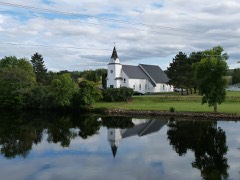 | Flambeau Mission Church | building | 1979 | 79000113 |
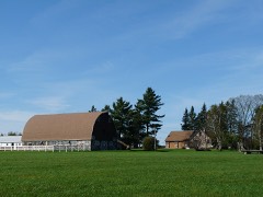 | Harold J. and Agnes McFarlane Stone House and Barn | building | 2016 | 16000803 |
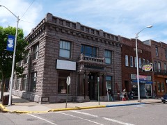 | State Bank of Ladysmith | building | 1980 | 80000192 |
Every wildfire the federal occurrence database records inside this county: 699 of them, burning about 1,469 acres. 8 started naturally and 94 were recorded as arson. Each settlement page carries the fires within five miles of it.
| Reported cause | Fires |
|---|---|
| Debris and open burning | 242 |
| Equipment and vehicle use | 136 |
| Arson/incendiarism | 94 |
| Missing data/not specified/undetermined | 84 |
| Recreation and ceremony | 37 |
| Railroad operations and maintenance | 25 |
| Smoking | 23 |
| Other causes | 20 |
| Power generation/transmission/distribution | 17 |
| Misuse of fire by a minor | 8 |
| Natural | 8 |
| Fireworks | 5 |
The five largest, by the area the report gives. Two of them were set deliberately.
| Date | Cause | Size | Reported by | Name on the report |
|---|---|---|---|---|
| 23 April 1993 | Arson/incendiarism | 75 acres | Wisconsin Department of Natural Resources | not named |
| 20 October 2003 | Recreation and ceremony | 60 acres | Wisconsin Department of Natural Resources | not named |
| 12 April 1998 | Power generation/transmission/distribution | 43 acres | Wisconsin Department of Natural Resources | not named |
| 14 April 1997 | Debris and open burning | 41 acres | Wisconsin Department of Natural Resources | not named |
| 14 April 1994 | Debris and open burning | 35 acres | Wisconsin Department of Natural Resources | not named |
| 16 May 1994 | Arson/incendiarism | 34 acres | Wisconsin Department of Natural Resources | not named |
| 5 May 2004 | Debris and open burning | 32 acres | Wisconsin Department of Natural Resources | not named |
| 29 October 2006 | Recreation and ceremony | 32 acres | Wisconsin Department of Natural Resources | not named |
Every settlement page carries the fires within five miles of it - see the settlement index below.
The NOAA Storm Events Database holds 202 reports for this county, causing no deaths, 35 injuries and about $28,256,000 in recorded property damage. Each settlement page carries the reports that name it.
| Kind of event | Reports |
|---|---|
| Thunderstorm Wind | 98 |
| Hail | 77 |
| Tornado | 16 |
| Flash Flood | 9 |
| Funnel Cloud | 1 |
| Heavy Rain | 1 |
The most serious of them, by death, then injury, then recorded damage. The accounts are quoted exactly as the forecast office filed them.
| When | Event | Place named | Harm | What the report says |
|---|---|---|---|---|
| September 2002 | Tornado (F3) | Ladysmith | 27 hurt, $25,000,000 | The first tornadic supercell to rake Wisconsin this day started just west of Ladysmith and tore through the downtown before moving into rural parts of eastern Rusk County. Injury totals fluctuated at first, but Rusk County Emergency Management stated there were approximately 27 injuries, none more serious than a broken leg. The NWS performed a damage survey the next day, and the most severe damage, rated F3, was in downtown Ladysmith. In this area 4 blocks wide and 16 blocks long, 40 buildings were destroyed and 159 damaged. One church was blown off its foundation, although during the damage survey, it was apparent that it had been barely attached to the foundation. A pickup truck was also picked up and thrown into a tree. Two old brick buildings collapsed. As the tornado reached the east side of Ladysmith, it weakened to F2 status. Once it left Ladysmith, the tornado continued on an eastward path, striking a number of rural farm houses and producing mostly F1 damage until it dissipated. |
| August 1975 | Tornado (F2) | not stated | 6 hurt, $25,000 | no account filed |
| July 1999 | Flash Flood | Bruce | 1 hurt | At least 6 inches of rain led to flooding of Clear Creek near Hwy 40 and County Road H. Normally 10 feet wide, it swelled to 100 yards wide. County Road H Bridge and nearby approaches washed out. Camper and farm machinery swept away. Basements flooded. Creek also flowed across Hwy 40. One man slightly injured when he drove into washed out bridge approach. |
| July 1997 | Tornado (F1) | Sheldon | 1 hurt | Tornado touched down just south of a northern branch of Holcomb Flowage near the entrance to Deer Tail Creek. The tornado proceeded to cross the flowage and strike a farmstead, ripping the roof off a farmhouse and causing one injury. |
| June 2001 | Thunderstorm Wind | Ladysmith | $1,000,000 | Measured at the DNR Forestry Station. Scattered damage to houses and outbuildings. Numerous trees and power lines down. Memorial Park in Ladysmith lost about 100 trees. One home lost part of its roof. Damage figure is the total from all storms in Rusk County from 1770 to 1815. |
| July 2019 | Tornado (EF0) | Weyerhaeuser | $500,000 | A NWS Storm Survey indicated that an EF0 tornado touched down on the west side of Fireside Lake, on Mud Lake Road. This tornado tracked approximately 7.6 miles northeast, before lifting on the east side of the Flambeau River, west of Sheep Camp Road. The tornado was on the ground for 14 minutes with a path width of 100 yards, and a maximum wind speed of 85 mph. Numerous trees were blown down or uprooted along the path. A few trees blew down on lake cabins causing considerable damage. No injuries occurred with this event. |
| May 2017 | Tornado (EF3) | Weyerhaeuser | $420,000 | The long-track tornado continued from Barron County into Rusk County and produced EF3 damage in the Conrath area. It entered Rusk County with an east-northeast track, but shortly thereafter began a gradual turn to the east and barely missed the village of Weyerhaeuser. Soon after passing Weyerhaeuser, it even turned a little toward the east-southeast (this happened at about 45.4063, -91.3583). The tornado then barely missed the village of Conrath. North of Conrath, however, the tornado leveled a house, and this is where the EF3 damage took place. Elsewhere, the tornado destroyed numerous sheds, outbuildings and garages and thousands of trees across the county. The tornado continued into southwestern Price County where it only produced EF0 damage and dissipated at 18:10 CST at 45.3916, -90.4919. |
| September 1982 | Tornado (F2) | not stated | $250,000 | no account filed |
| July 1967 | Tornado (F2) | not stated | $250,000 | no account filed |
| June 1958 | Tornado (F2) | not stated | $250,000 | no account filed |
| May 1998 | Thunderstorm Wind | Ladysmith | $230,000 | Roof ripped off apartment building and restaurant. Flying debris from apartment building damaged nearby motel. 3,000 pound pontoon boat on Lake Flambeau blown a distance of 125 feet and destroyed. Many trees blown over. Numerous garages and sheds destroyed. |
| July 2019 | Thunderstorm Wind | Bruce | $150,000 | A NWS Storm Survey indicated wind damage occurred north of Bruce, and tracked eastward for several miles. The wind downed numerous trees, damaged a barn and outbuilding northwest of Ladysmith. Winds were estimated up to 75 mph as most of the barn roof was damaged or lifted off. |
| August 2011 | Flash Flood | Hawkins | $50,000 | Two county roads were washed out in far eastern Rusk County due to excessive rainfall of two to four inches in less than 2 hours. |
| July 2021 | Thunderstorm Wind | Bruce | $25,000 | There were approximately 20-30 trees that were blown down on the roadways with most being poplar or dead hardwoods. There were also some houses that were damaged from downed trees in Bruce. |
| August 1973 | Tornado (F1) | not stated | $25,000 | no account filed |
| May 1959 | Tornado (F2) | not stated | $25,000 | no account filed |
| June 1950 | Tornado | not stated | $25,000 | no account filed |
| June 2021 | Tornado (EF0) | Bruce | $20,000 | A tornado moved toward the north-northwest and struck a farm toward the end of its path. The roof of a shed was lifted up and pushed, some concrete blocks were knocked over. Siding of a house was ripped off. A few trees were downed. The starting point was based on video. Three videos were available. The damage survey of the farm was provided by a storm chaser. |
| July 2010 | Thunderstorm Wind | Ladysmith | $10,000 | Several trees were blown down between Ladysmith and Glen Flora, Wisconsin. Some trees fell on power lines. |
| June 2021 | Thunderstorm Wind | Conrath | $1,000 | A large tank was lifted several hundred feet into the air, with damage reported to the farms gate. |
| May 2025 | Thunderstorm Wind | Ladysmith | - | A storm survey determined an area of significant thunderstorm wind damage along County Highway P southeast of Ladysmith. There were several downed trees and snapped or leaning power poles. The most significant damage was near the intersection of Roses Road and County Highway P where a house incurred roof damage and loss of soffits, and the house was moved slightly. Wind gusts were estimated to be near 100 mph. |
| May 2025 | Thunderstorm Wind | Ladysmth Rusk Co Arp | - | A storm survey determined significant thunderstorm wind damage near the Flambeau River and Dairyland Reservoir. There were several downed trees as well as twisted and moved docks. A pontoon had been partially lifted onto a nearby pontoon in Groothousen Bay. |
| June 2024 | Thunderstorm Wind | Sheldon | - | Several trees were down. There was minor damage to a hoop barn greenhouse. |
| July 2023 | Thunderstorm Wind | Hawkins | - | Several reports were received near the town of Hawkins, WI that trees and powerlines were downed by strong thunderstorm wind gusts. |
| May 2021 | Thunderstorm Wind | Conrath | - | Several trees were blown down, including one across Highway D. |
| May 2021 | Thunderstorm Wind | Sheldon | - | There were about a dozen trees blown down, or uprooted in and around Sheldon. |
| April 2020 | Hail | Bruce | - | There was a swath of large hail, the largest was hen size northeast of Ladysmith that occurred from north of Bruce, east-southeast to Hawkins. Radar data, which kept the intensity throughout the storm that moved across Rusk County was used for timing and length. |
| July 2019 | Thunderstorm Wind | Hawkins | - | A NWS Storm Survey indicated that straight-line winds, up to 80 mph, occurred in a small part of far northeast Rusk County. Based on the survey, the damage path that occurred in Sawyer County, continued along the path into far northeast Rusk County. There were reports of numerous large trees blown down across this area. |
| July 2019 | Thunderstorm Wind | Weyerhaeuser | - | Hundreds of trees were downed in a swath that was several miles wide across Rusk Township in the southwest corner of Rusk County. Some power lines were also downed, but no property damage was reported. |
| June 2018 | Thunderstorm Wind | Bruce | - | Several power lines were blown down southwest of Ladysmith, along Strom Road. |
| August 2018 | Thunderstorm Wind | Weyerhaeuser | - | A large tree was blown down in Weyerhaeuser. |
| August 2018 | Thunderstorm Wind | Conrath | - | A large tree was blown down in Conrath. |
| August 2018 | Thunderstorm Wind | Glen Flora | - | A large tree was blown down west of Glen Flora. |
| June 2017 | Thunderstorm Wind | Weyerhaeuser | - | Large trees and branches were blown down. |
| June 2017 | Thunderstorm Wind | Ladysmith | - | Numerous trees of various sizes were blown down. Also, a car was blown off the road. |
| July 2017 | Hail | Tony | - | Half dollar size hail was reported at Highway 8 and Flambeau Drive, near Tony, Wisconsin. |
| July 2017 | Thunderstorm Wind | Glen Flora | - | Large tree branches were blown down near Stoker Road and Highway 8. |
| July 2017 | Hail | Ingram | - | Half dollar hail was reported at Highway 8 and 73 near Ingram, Wisconsin. |
| May 2016 | Heavy Rain | Ladysmith | - | A 4.20 inch rainfall report was measured in Ladysmith. |
| May 2016 | Flash Flood | Ladysmith | - | Several bands of torrential rainfall occurred during the afternoon of Tuesday, May 31st. With rainfall rates as high as 2 inches per hour, runoff was rapid which caused a part of County Road J north of Ladysmith to be inundated with flood waters. |
| September 2014 | Thunderstorm Wind | Weyerhaeuser | - | Several large tree branches were blown down east of Rice Lake. |
| September 2014 | Thunderstorm Wind | Tony | - | Large trees were blown down on Highway 8, east of Ladysmith. |
| July 2014 | Thunderstorm Wind | Ladysmith | - | Several trees were blown down near the intersection of Cut Off Road and Highway 27, and Cemetery Road. |
| August 2013 | Funnel Cloud | Sheldon | - | Law enforcement officials reported a funnel cloud northeast of Sheldon, along Highway D, and Pioneer Road. |
| August 2013 | Thunderstorm Wind | Ladysmith | - | Several large trees were blown down along Highway 8, between Ladysmith, and the town of Tony. |
| June 2013 | Thunderstorm Wind | Hawkins | - | Several trees and power lines were blown down. |
| July 2012 | Thunderstorm Wind | Bruce | - | A few power lines were blown down near Bruce, Wisconsin. |
| August 2011 | Hail | Bruce | - | Winds also gusted to 50 mph in Bruce. |
| July 2011 | Thunderstorm Wind | Ladysmith | - | A few large trees and power lines were blown down near Ladysmith, Wisconsin. |
| July 2011 | Thunderstorm Wind | Tony | - | A few trees and power lines were blown down near Troy. |
| May 2010 | Thunderstorm Wind | Murry | - | Thunderstorm winds caused a 12 inch diameter tree branch to be blown down. |
| May 2010 | Thunderstorm Wind | Hawkins | - | Severe wind gusts caused trees to be blown down near Hawkins, Wisconsin. |
| May 2010 | Thunderstorm Wind | Ingram | - | Severe winds caused trees to be blown down near Ingram, and rural areas north of Ladysmith. |
| July 2010 | Thunderstorm Wind | Weyerhaeuser | - | A large tree and numerous branches were blown down near Highway 40. |
| May 2009 | Hail | Bruce | - | Nickel size hail covered the ground two miles north of Bruce. |
| June 2009 | Flash Flood | Port Arthur | - | Local Law Enforcement Officials reported water over the road near the intersection of Highway 27 and Broken Arrow Road. In addition, the Willard Township area had many flooded fields. |
| July 2008 | Thunderstorm Wind | Ingram | - | Tree and several branches downed at the intersection of Town Line road and Highway 73. |
| July 2008 | Hail | Conrath | - | Hail occurred at County Road V and Pioneer Road, or about 3 miles North of Sheldon. |
| August 2008 | Thunderstorm Wind | Bruce | - | Many trees toppled, power pole downed, and some trees blocking Highway 8. |
| May 2007 | Thunderstorm Wind | Weyerhaeuser | - | Numerous small trees down. |
The Survey's mineral resources record lists 133 workings inside this county. 6 still produce and 127 are closed or unrecorded. Each settlement page carries the workings within five miles of it.
| Commodity | Workings |
|---|---|
| Sand and Gravel, Construction | 130 |
| Copper | 1 |
| Silver, Gold, Zinc | 1 |
| Lead | 1 |
| Zinc, Copper | 1 |
| Gold, Silver | 1 |
| Gold, Copper | 1 |
| Silver | 1 |
The least common of them first, because a county's hundredth gravel pit says nothing its first ten did not.
| Where | Site | Commodity | Status | Recorded |
|---|---|---|---|---|
| Eisenbrey Deposit | Zinc, Copper, Gold, Silver | Unknown | 1973 | |
| Flambeau Mine | Copper, Silver, Gold, Zinc, Lead | Producer | 1968, 1993 | |
| Flambeau/Ladysmith Mine | Gold, Copper, Silver | Plant | 1968, 1992 | |
| Airport View Gravel Deposit | Sand and Gravel, Construction | Occurrence | ||
| Amocoy Lake Gravel Pit | Sand and Gravel, Construction | Past Producer | ||
| Apollonia Gravel Deposit | Sand and Gravel, Construction | Occurrence | ||
| Big Bend Gravel Deposit | Sand and Gravel, Construction | Occurrence | ||
| Big Sky Sand Deposit | Sand and Gravel, Construction | Occurrence | ||
| Blank Lake Gravel Deposit | Sand and Gravel, Construction | Occurrence | ||
| Bowker Lake Sand Deposit | Sand and Gravel, Construction | Occurrence | ||
| Bruce Gravel Pit | Sand and Gravel, Construction | Past Producer | ||
| Bruno Lake Gravel Deposit | Sand and Gravel, Construction | Occurrence | ||
| Buff Creek Gravel Deposit | Sand and Gravel, Construction | Occurrence | ||
| Cathedral Point Gravel Deposit | Sand and Gravel, Construction | Occurrence | ||
| Channel Gravel Pit | Sand and Gravel, Construction | Past Producer | ||
| Chippewa River Gravel Deposit | Sand and Gravel, Construction | Occurrence | ||
| Clear Creek Gravel Deposit #1 | Sand and Gravel, Construction | Occurrence | ||
| Clear Creek Gravel Deposit #2 | Sand and Gravel, Construction | Occurrence | ||
| Clear Meadows Gravel Deposit | Sand and Gravel, Construction | Occurrence | ||
| Cliff Edge Gravel Pit | Sand and Gravel, Construction | Past Producer | ||
| Country Place Gravel Pit | Sand and Gravel, Construction | Past Producer | ||
| Craters Gravel Deposit | Sand and Gravel, Construction | Occurrence | ||
| Creek Bend Gravel Deposit | Sand and Gravel, Construction | Occurrence | ||
| Creek Side Gravel Deposit | Sand and Gravel, Construction | Occurrence | ||
| Creeking Creek Gravel Pit | Sand and Gravel, Construction | Past Producer | ||
| Crestside Gravel Deposit | Sand and Gravel, Construction | Occurrence | ||
| Deer Tail Creek Gravel Pit | Sand and Gravel, Construction | Past Producer | ||
| Deer Trail Creek Gravel Deposit | Sand and Gravel, Construction | Occurrence | ||
| Deer Trail Creek Gravel Pit | Sand and Gravel, Construction | Past Producer | ||
| Devils Creek Gravel Deposit | Sand and Gravel, Construction | Occurrence | ||
| Double Branch Gravel Pit | Sand and Gravel, Construction | Past Producer | ||
| Flambeau River Gravel Deposit | Sand and Gravel, Construction | Occurrence | ||
| Flambeau River Gravel Pit #1 | Sand and Gravel, Construction | Past Producer | ||
| Glen Flora Gravel Deposit | Sand and Gravel, Construction | Occurrence | ||
| Glen Flora Gravel Pit #1 | Sand and Gravel, Construction | Past Producer | ||
| Glen Flora Gravel Pit #2 | Sand and Gravel, Construction | Past Producer | ||
| Hawkins Gravel Deposit | Sand and Gravel, Construction | Occurrence | ||
| Hay Creek Gravel Deposit | Sand and Gravel, Construction | Occurrence | ||
| Hay Creek Gravel Pit | Sand and Gravel, Construction | Past Producer | ||
| High Notch Gravel Deposit | Sand and Gravel, Construction | Occurrence | ||
| High Post Gravel Pit | Sand and Gravel, Construction | Past Producer | ||
| High Range Gravel Deposit | Sand and Gravel, Construction | Occurrence | ||
| High Water Gravel Pit | Sand and Gravel, Construction | Past Producer | ||
| Highway Edge Gravel Deposit | Sand and Gravel, Construction | Occurrence | ||
| Hillside Gravel Deposit | Sand and Gravel, Construction | Occurrence | ||
| Historic Road Gravel Pit #1 | Sand and Gravel, Construction | Past Producer | ||
| Historic Road Gravel Pit #2 | Sand and Gravel, Construction | Past Producer | ||
| Imalone Gravel Deposit | Sand and Gravel, Construction | Occurrence | ||
| Imalone Gravel Pit | Sand and Gravel, Construction | Past Producer | ||
| Island Lake Gravel Pit | Sand and Gravel, Construction | Past Producer | ||
| Josie Creek Gravel Pit | Sand and Gravel, Construction | Past Producer | ||
| Jump River Sand Deposit | Sand and Gravel, Construction | Occurrence | ||
| Kief Road Gravel Deposit | Sand and Gravel, Construction | Occurrence | ||
| Koehler Lake Gravel Deposit | Sand and Gravel, Construction | Occurrence | ||
| L. Thornapple River Gravel Deposit | Sand and Gravel, Construction | Occurrence | ||
| Ladysmith Concrete Pit | Sand and Gravel, Construction | Producer | ||
| Lake Laverne Sand Deposit #1 | Sand and Gravel, Construction | Occurrence | ||
| Lake Laverne Sand Deposit #2 | Sand and Gravel, Construction | Occurrence | ||
| Lakeshore Gravel Pit | Sand and Gravel, Construction | Past Producer | ||
| Little Jump River Gravel Pit | Sand and Gravel, Construction | Past Producer | ||
| Little Water Gravel Pit | Sand and Gravel, Construction | Past Producer | ||
| Lookout Point Gravel Pit | Sand and Gravel, Construction | Past Producer | ||
| Lost Swamp Gravel Pit | Sand and Gravel, Construction | Past Producer | ||
| Low Bottom Gravel Deposit | Sand and Gravel, Construction | Occurrence | ||
| Lowline Gravel Deposit | Sand and Gravel, Construction | Occurrence | ||
| Lowlying Gravel Pit | Sand and Gravel, Construction | Past Producer | ||
| Maple Creek Gravel Deposit #1 | Sand and Gravel, Construction | Occurrence | ||
| Mcgee Lake Gravel Pit | Sand and Gravel, Construction | Past Producer | ||
| Mcgee Lake View Gravel Pit | Sand and Gravel, Construction | Past Producer | ||
| Meandering Hills Gravel Pit | Sand and Gravel, Construction | Past Producer | ||
| Moose Ear Creek Gravel Deposit | Sand and Gravel, Construction | Occurrence | ||
| Moose Ear Creek Gravel Deposit #1 | Sand and Gravel, Construction | Occurrence | ||
| Moose Ear Creek Gravel Pit | Sand and Gravel, Construction | Past Producer | ||
| Namanie Sand Pit | Sand and Gravel, Construction | Past Producer | ||
| Nineteenth Hole Gravel Pit | Sand and Gravel, Construction | Past Producer | ||
| North Fork Creek Gravel Pit | Sand and Gravel, Construction | Past Producer | ||
| Off Road Gravel Deposit | Sand and Gravel, Construction | Occurrence | ||
| Open End Gravel Pit | Sand and Gravel, Construction | Past Producer | ||
| Outlet Point Gravel Pit | Sand and Gravel, Construction | Past Producer | ||
| Parkside Gravel Deposit | Sand and Gravel, Construction | Occurrence | ||
| Perdziak Lake Gravel Deposit | Sand and Gravel, Construction | Occurrence | ||
| Pickeral Lakes Gravel Deposit | Sand and Gravel, Construction | Occurrence | ||
| Pieper Creek Gravel Deposit | Sand and Gravel, Construction | Occurrence | ||
| Pieper Creek Sand Pit | Sand and Gravel, Construction | Past Producer | ||
| Pipeline Site Gravel Deposit | Sand and Gravel, Construction | Occurrence | ||
| Port Arthur Gravel Pit | Sand and Gravel, Construction | Past Producer | ||
| Port Side Gravel Pit | Sand and Gravel, Construction | Past Producer | ||
| Reservoir Gravel Pit | Sand and Gravel, Construction | Past Producer | ||
| Riley Pit | Sand and Gravel, Construction | Producer | ||
| River Edge Gravel Pit | Sand and Gravel, Construction | Past Producer | ||
| River Rapids Gravel Deposit | Sand and Gravel, Construction | Occurrence | ||
| Riverbank Gravel Deposit | Sand and Gravel, Construction | Occurrence | ||
| Riverviw Gravel Pit | Sand and Gravel, Construction | Past Producer | ||
| Roadside Gravel Pit | Sand and Gravel, Construction | Past Producer | ||
| Rolling Slopes Gravel Deposit | Sand and Gravel, Construction | Occurrence | ||
| Running Water Gravel Deposit | Sand and Gravel, Construction | Occurrence | ||
| S Br Twin Creek Gravel Deposit | Sand and Gravel, Construction | Occurrence | ||
| Sand Lake Gravel Pit | Sand and Gravel, Construction | Past Producer | ||
| Scott Pit | Sand and Gravel, Construction | Producer | ||
| Shakey Edge Gravel Pit | Sand and Gravel, Construction | Past Producer | ||
| Shakey Ridge Gravel Deposit | Sand and Gravel, Construction | Occurrence | ||
| Shallow Swamp Gravel Pit | Sand and Gravel, Construction | Past Producer | ||
| Shamrock Lake Gravel Deposit | Sand and Gravel, Construction | Occurrence | ||
| Shamrock Lake Gravel Pit #1 | Sand and Gravel, Construction | Past Producer | ||
| Shamrock Lake Gravel Pit #2 | Sand and Gravel, Construction | Past Producer | ||
| Sheldon Pit | Sand and Gravel, Construction | Unknown | ||
| Slippery Swamp Gravel Deposit | Sand and Gravel, Construction | Occurrence | ||
| Small Lakes Gravel Pit | Sand and Gravel, Construction | Past Producer | ||
| Smooth Water Gravel Deposit | Sand and Gravel, Construction | Occurrence | ||
| Soft Maple Creek Sand Deposit | Sand and Gravel, Construction | Occurrence | ||
| Soft Maple Creek Sand Pit | Sand and Gravel, Construction | Past Producer | ||
| Soft Winds Gravel Pit | Sand and Gravel, Construction | Past Producer | ||
| Spotted Lakes Gravel Pit | Sand and Gravel, Construction | Past Producer | ||
| Stevens Bros. Pit | Sand and Gravel, Construction | Unknown | ||
| Stray Swamp Gravel Pit | Sand and Gravel, Construction | Past Producer | ||
| Sunfish Lake Gravel Pit | Sand and Gravel, Construction | Past Producer | ||
| Swamp Midst Gravel Pit | Sand and Gravel, Construction | Past Producer | ||
| Swampside Gravel Deposit | Sand and Gravel, Construction | Occurrence | ||
| Swift Current Gravel Deposit | Sand and Gravel, Construction | Occurrence | ||
| Ten Mile Creek Gravel Deposit | Sand and Gravel, Construction | Occurrence | ||
| Ten Mile Creek Gravel Pit | Sand and Gravel, Construction | Past Producer | ||
| Thumbpoint Sand Deposit | Sand and Gravel, Construction | Occurrence | ||
| Town Edge Gravel Deposit | Sand and Gravel, Construction | Occurrence | ||
| Twin Creek Gravel Deposit | Sand and Gravel, Construction | Occurrence | ||
| Twin Lakes Gravel Pit | Sand and Gravel, Construction | Past Producer | ||
| Twin Rivers Gravel Deposit | Sand and Gravel, Construction | Occurrence | ||
| Valley K Gravel Deposit | Sand and Gravel, Construction | Occurrence | ||
| Vanishing Creek Gravel Pit | Sand and Gravel, Construction | Past Producer | ||
| Wading Ponds Gravel Pit | Sand and Gravel, Construction | Past Producer | ||
| Washington Pit | Sand and Gravel, Construction | Producer | ||
| Waterway Gravel Deposit | Sand and Gravel, Construction | Occurrence | ||
| Wavering Creek Gravel Deposit | Sand and Gravel, Construction | Occurrence | ||
| Winding Top Gravel Deposit | Sand and Gravel, Construction | Occurrence |
Named settlements recorded in the Geographic Names Information System, each with the topographic sheets covering it. Villages, hamlets and abandoned places alike. Each is shown with the nearest named watercourse or landform and the survey quadrangle it falls on.
Big Bend town · 54757 · On Swift Creek · Fireside Lakes quadrangle
7 sheets, 1948 to 1980
Washington town · 54819 · Near Pine Island · Flambeau Ridge quadrangle
7 sheets, 1948 to 1980
Sheldon village · 54766 · On Alder Creek · Sheldon quadrangle
7 sheets, 1947 to 1980