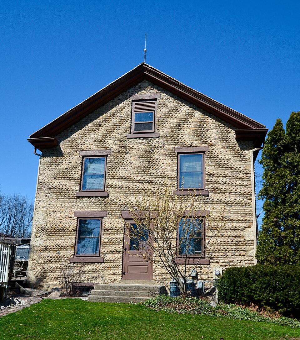
Listed on the National Register of Historic Places in 1980.
From the record
“The Haseltine Cobblestone House is a Greek Revival-styled home clad in cobblestone and built in 1842 in Big Bend, Waukesha County, Wisconsin for one of the town's first settlers.”
Wikipedia article Haseltine Cobblestone House, CC BY-SA 4.0.
One of 153 National Register listings published here for Waukesha County · listed in 1980 · category: Building.
National Register reference number.80000204- the number the National Park Service assigned this property when it was listed, and the key its nomination file is catalogued under at the National Archives.
J. H. STICKNE Y, farmer. Sees. 23, 14 and 22 ; P. O. Big Bend ; born in Andover, Vt., 1811, resided there until he was 22, when he went to Troy, N. Y., and after a year, to Boston, where he spent three ; returning to Andover, he remained a short time, and reached Vernon on the 18th of August, 1838 ; a carpenter by trade, he worked at building log houses and barns for the settlers. Married in 1840, Miss E. A., daughter of Col. Orien Haseltine, and settled on 240 acres of his present farm ; on this the Indians had formerly a cornfield, the stalks and cobs being still visible. None of the pioneers of Vernon have done better than he, as he is now the large.9t land owner in it, having 620 acres, and on it more and better timber than any man in the county ; his maple grove is simply grand; the yield of 1,000 pounds of sugar per annum, adding to its attractions; in these woods in an early day, Mr. S had many an exciting, and sometimes dangerous adventure with the half-wild hogs, and wilder wolves and lynxes. He is a Republican, and was the third Treasurer ot Vernon. In 1847, he removed to Dodge Co., W^., and remained until 1852. Mr. and Mrs. S. have nine living children - Warren, Annie, Alice, Rollin, Volney, Emily, Perris, Elva and Ida ; also an adopted son, George. To these children, Mr. S. has given over much of the care involved in managing the estate.
Regional context, not property-specific
evidence. The
federal wildfire occurrence database
lists 32 fires within 5 miles of Haseltine Cobblestone House
between 2010 and 2020, burning about 403 acres in total. 2 started naturally. 4 were recorded as arson.
Distance is straight-line from the map coordinates, so a fire counted
here may appear on a neighbouring settlement's page as well.
Reported cause
Fires
Missing data/not specified/undetermined
16
Debris and open burning
6
Arson/incendiarism
4
Recreation and ceremony
2
Natural
2
Equipment and vehicle use
2
The most recent of
them, most recent first, with the day each was reported and the service
that recorded it.
Regional context, not property-specific
evidence. The federal mineral resources record lists
6 workings within 5 miles of Haseltine Cobblestone House: 6 producers.
All of them still produce. What was taken out: Sand and Gravel, Construction. Distance is straight-line from the
map coordinates, so a quarry counted here may appear on a neighbouring
settlement's page as well.
Regional context, not property-specific
evidence. The National Weather Service names
Big Bend, the town this property stands in, in 14 storm reports between 1998 and 2025: 5 hail, 4 thunderstorm wind, 3 tornado, 2 flash flood.
No death or injury is recorded in these reports. Each account below is quoted exactly as the forecast office
filed it, from the NOAA Storm Events Database, and each date
opens the federal record of that event.
This EF1 tornado affected the Big Bend and Muskego area, and spun up a little more than 2 miles north of Big Bend about 1/10 of a mile southeast of the intersection of Interstate 43 and STH 164. The tornado moved east, dissipating about 1/2 mile south of Tess Corners, just northwest of the intersection of Woods Road and Durham Drive. The roof of the Tess Corners Fire Department tore off, and the U.S. Post Office building in Muskego was damaged when an air conditioning unit was blown off the roof. Several post office vehicles were also damaged. The building housing Muskego Beer and Liquor was badly damaged when a wall collapsed and destroyed half the building. All together, 35 residential dwellings were minimally affected, and 41 homes sustained minor damage. Seventeen businesses were minimally affected, and 1 sustained major damage. Some crops were damaged, but no information on loss estimates was available. Total estimated private sector damage was about $430,000. Public sector structural damage totaled about $15,000. Additionally, other public service (non-damage) costs totaled $65,000; which included $45,000 for debris clearance, $10,000 for protective measures, and $10,000 for road systems. Hundreds of trees were uprooted or damaged. Starting location point was Lat 42.91015 Lon -88.21483 with the ending point Lat 42.91118 Lon -88.09850. The EF-rating was based on DI 27 (TH) DOD3 which suggests a wind speed of 105 mph. The average path width was 90 yards.
An EF2 tornado developed about 1 mile south of Big Bend, 1/8 mile west of of STH 164 between Henneberry Ave. and Kelsey Ave. The tornado partially uprooted trees, broke tree branches, caused corn crop damage and destroyed a garage and pole shed along a 1 mile path that averaged 70 yards in width. Additionally, it flipped over a camping trailer and carried a tool box about 1/2 mile away. The tornado ended about 1.7 miles southeast of Big Bend, 1/3 mile east-northeast of the intersection of Crowbar Dr. and Parker Dr. The EF2 estimated wind speeds of 115 to 120 mph were based on DI 27(TH) DOD4. The exact start location is Lat 42.86466 and Lon -88.20040. The exact end location is Lat 42.86569 and Lon -88.18079.
Heavy rains resulted in flash flooding as water reached depths of 3 feet or more and several cars stalled. This was one of 3 flash floods in Waukesha County on June 7th. Some crop damage was noted in nearby rural areas around Pewaukee. Another round of heavy rains on June 8th resulted in flash flooding around North Prairie. Collectively, each of these 4 flash floods resulted in home and business damage along with some crop losses. It was nearly impossible to break down the damages by flash flood. Therefore, the collective breakdown is provided in the June 8th StormData entry for Waukesha County.
No historic map-sheet match is published
for this property yet. That does not mean no map exists. This record needs
a coordinate-quality review before it can be joined to a sheet boundary.
Browse the county's mapped places while that work is
pending.
Listed places nearby
6 within 8 miles
Other National Register properties close
enough to walk or drive between, ordered by distance from this one. Both
positions come from the same geocoding pass that matched these properties
to their map sheets.
Listing record. National Park Service National Register of Historic Places, listed-properties dataset, current to 2026-05-22.
Map join. Address geocoded through the United States Census geocoder, then tested against the published boundary of every sheet in the USGS Historical Topographic Map Collection.
How this page is made. Listing fields come from federal records; map-sheet coverage is a labelled coordinate-to-boundary calculation, not a source-field claim.
Wildfire. Short, Karen C. 2022. Spatial wildfire occurrence data for the United States, 1992-2020 [FPA_FOD_20221014]. 6th Edition. Fort Collins, CO: Forest Service Research Data Archive. https://doi.org/10.2737/RDS-2013-0009.6 Collected with United States Government funding and usable without additional permissions or fees.
Mines and quarries. USGS Mineral Resources Data System (MRDS) https://mrdata.usgs.gov/mrds/ A work of the United States government, no copyright under 17 U.S.C. 105.
Storms. NOAA National Centers for Environmental Information, Storm Events Database https://www.ncei.noaa.gov/stormevents/ A work of the United States government, no copyright under 17 U.S.C. 105. Narratives are quoted verbatim from the National Weather Service report and are not edited or summarised.
 Block