 Block
From the record
One of 153 National Register listings published here for Waukesha County · listed in 2004 · category: District.
Sources: the case file at the National Archives · the National Register database, National Park Service
Listed on the National Register of Historic Places in 2004.
One of 153 National Register listings published here for Waukesha County · listed in 2004 · category: District.
Sources: the case file at the National Archives · the National Register database, National Park Service
Regional context, not property-specific evidence. The federal wildfire occurrence database lists 13 fires within 5 miles of Pearl and Grand Avenue Historic District between 2008 and 2020, burning about 71 acres in total. None started naturally. 3 were recorded as arson. Distance is straight-line from the map coordinates, so a fire counted here may appear on a neighbouring settlement's page as well.
| Reported cause | Fires |
|---|---|
| Missing data/not specified/undetermined | 7 |
| Arson/incendiarism | 3 |
| Debris and open burning | 2 |
| Recreation and ceremony | 1 |
The most recent of them, most recent first, with the day each was reported and the service that recorded it.
| Date | Cause | Size | Reported by | Name on the report |
|---|---|---|---|---|
| 26 July 2018 | Missing data/not specified/undetermined | under an acre | Wisconsin Department of Natural Resources | 73 |
| 23 June 2018 | Missing data/not specified/undetermined | 1.0 acres | Wisconsin Department of Natural Resources | 312 |
| 8 May 2018 | Debris and open burning | under an acre | Wisconsin Department of Natural Resources | 233 |
| 7 May 2018 | Missing data/not specified/undetermined | under an acre | Wisconsin Department of Natural Resources | 18092 |
| 30 May 2019 | Arson/incendiarism | 1.0 acres | Wisconsin Department of Natural Resources | 19128 |
| 3 May 2020 | Missing data/not specified/undetermined | 15 acres | Wisconsin Department of Natural Resources | 20089 |
| 5 April 2020 | Recreation and ceremony | 10 acres | Wisconsin Department of Natural Resources | 163 |
| 23 April 2008 | Arson/incendiarism | 38 acres | Wisconsin Department of Natural Resources | not named |
Regional context, not property-specific evidence. The federal mineral resources record lists 3 workings within 5 miles of Pearl and Grand Avenue Historic District: 1 occurrence, 1 past producer, 1 producer. 1 still produces. What was taken out: Sand and Gravel, Construction. Distance is straight-line from the map coordinates, so a quarry counted here may appear on a neighbouring settlement's page as well.
| Where | Site | Commodity | Status | Recorded |
|---|---|---|---|---|
| Army Lake Sand Deposit | Sand and Gravel, Construction | Occurrence | ||
| Bishop Pit | Sand and Gravel, Construction | Past Producer | ||
| Hales Corners Pit | Sand and Gravel, Construction | Producer |
Regional context, not property-specific evidence. The National Weather Service names Mukwonago, the town this property stands in, in 31 storm reports between 1996 and 2025: 16 hail, 9 thunderstorm wind, 3 flash flood, 1 flood. No death or injury is recorded in these reports. Each account below is quoted exactly as the forecast office filed it, from the NOAA Storm Events Database, and each date opens the federal record of that event.
| When | Event | Place named | Harm | What the report says |
|---|---|---|---|---|
| October 1996 | Hail | Mukwonago | $1,200,000 | no account filed |
| August 2007 | Flash Flood | Mukwonago | $100,000 | Flash flooding affected the Mukwanago area after heavy rains of 6.8 inches fell overnight. Water depths on some city strees reached 2 to 4 feet, and significant soil erosion was noted in the surrounding countryside. At least 25 homes sustained minor flood damage to basement contents. Gravel shoulder washouts occurred and crops in the area were damaged. To the west, a spotter at a location .6SE Eagle had 4.76 overnight. |
| September 2005 | Flash Flood | Mukwonago | $50,000 | Flooded roads and some flooded basements were reported across portions of central and southern Waukesha county, damaging contents inside. |
| June 1999 | Thunderstorm Wind | Mukwonago | $40,000 | no account filed |
| August 2008 | Lightning | Mukwonago | $25,000 | Lightning struck a garage on Cherry Lane, causing a small fire in an upstairs bedroom. The contents was a total loss. |
| October 2013 | Flash Flood | Mukwonago | $14,000 | Many cars disabled due to severe street flooding in the city of Waukesha. Street flooding throughout eastern Waukesha County. Several manhole covers removed from flooding. The new Health and Human Services Building in the city of Waukesha was flooded. |
| April 1997 | Thunderstorm Wind | Mukwonago | $12,000 | no account filed |
| July 2021 | Thunderstorm Wind | Mukwonago | $3,000 | Tree limbs down, transformer exploded behind Village of Mukwonago Police Department. |
| August 2015 | Hail | Mukwonago | $3,000 | The hail put holes in the roof of a camper and dented a truck. |
| May 2012 | Thunderstorm Wind | Mukwonago | $2,000 | A trained spotter reported an estimated thunderstorm wind gust of 65 mph (56 knots) two miles bnorth of Mukwonago. |
| July 2005 | Thunderstorm Wind | Mukwonago | $1,000 | no account filed |
| June 1997 | Thunderstorm Wind | Mukwonago | $1,000 | no account filed |
| March 2017 | Hail | Mukwonago | - | Penny to three quarter inch diameter hail for about 10 minutes. |
| May 2013 | Hail | Mukwonago | - | The public reported hail up to 1.25 inches in diameter about 1 mile southwest of Mukwonago. |
| June 2011 | Thunderstorm Wind | Mukwonago | - | Part of a line of severe thunderstorms with damaging wind gusts up to 70 mph (60 knots) that blew down numerous trees moved through northeast and eastern Waukesha County during the middle afternoon of June 21st. |
| June 2010 | Thunderstorm Wind | Mukwonago | - | Powerful thunderstorm wind gusts toppled several large trees. |
| June 2009 | Tornado (EF0) | Mukwonago | - | A weak, minimal EFO tornado spun up along a line of severe thunderstorms that progressed across southern Wisconsin. The responsible supercell actually developed a mesocyclone when it crossed the Jefferson-Waukesha County line west of the village of Eagle. The tornado started at the west end of Lower Phantom Lake and tracked just north of east through the city of Mukwanago and dissipated near the intersection of the Mukwanago River and the Fox River east of the city. Damage was limited to uprooted trees and broken large limbs. The winds were estimated at 56 to 61 knots (65-70 mph). The average path width was about 30 yards. The compass bearing was about 80 degrees. Start and ending location was 42.86003/-88.36303 and 42.86666/-88.30144. DI#27(TH), DOD2. |
| September 2005 | Thunderstorm Wind | Mukwonago | - | There were widespread reports of trees and powerlines toppled across Waukesha County. Law enforcement reported a measured gust of 58 knots (67 mph) around the city of Waukesha. Trained spotters estimated wind gusts of 70 to 74 knots (80 to 85 mph) embedded within the larger area of damaging winds between just south of Waukesha through Brookfield. |
| May 2025 | Hail | Mukwonago | - | no account filed |
| April 2025 | Hail | Mukwonago | - | no account filed |
| May 2024 | Hail | Mukwonago | - | no account filed |
| July 2023 | Hail | Mukwonago | - | no account filed |
| April 2016 | Hail | Mukwonago | - | no account filed |
| August 2015 | Hail | Mukwonago | - | no account filed |
| June 2009 | Hail | Mukwonago | - | no account filed |
| March 2007 | Hail | Mukwonago | - | no account filed |
| May 2005 | Hail | Mukwonago | - | no account filed |
| November 2005 | Hail | Mukwonago | - | no account filed |
| May 2000 | Hail | Mukwonago | - | no account filed |
| May 2000 | Hail | Mukwonago | - | no account filed |
| July 2000 | Flood | Mukwonago | - | no account filed |
No historic map-sheet match is published for this property yet. That does not mean no map exists. This record needs a coordinate-quality review before it can be joined to a sheet boundary. Browse the county's mapped places while that work is pending.
Other National Register properties close enough to walk or drive between, ordered by distance from this one. Both positions come from the same geocoding pass that matched these properties to their map sheets.
| Photograph | Property | Distance | Listed |
|---|---|---|---|
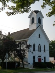 | United Unitarian and Universalist Church | 0.3 miles | 1987 |
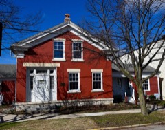 | Sewall Andrews House | 0.3 miles | 1981 |
| J. C. Booth House | 5.1 miles | 1973 | |
| Saylesville Historic District | 5.7 miles | 2003 | |
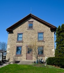 | Haseltine Cobblestone House | 6.5 miles | 1980 |
| Ahira R. Hinkley House | 6.6 miles | 1974 |
| National Archives record | The nomination case file for reference 04001004 in Record Group 79. |
| Waukesha County | All 153 listed properties in this county. |