BlockBefore
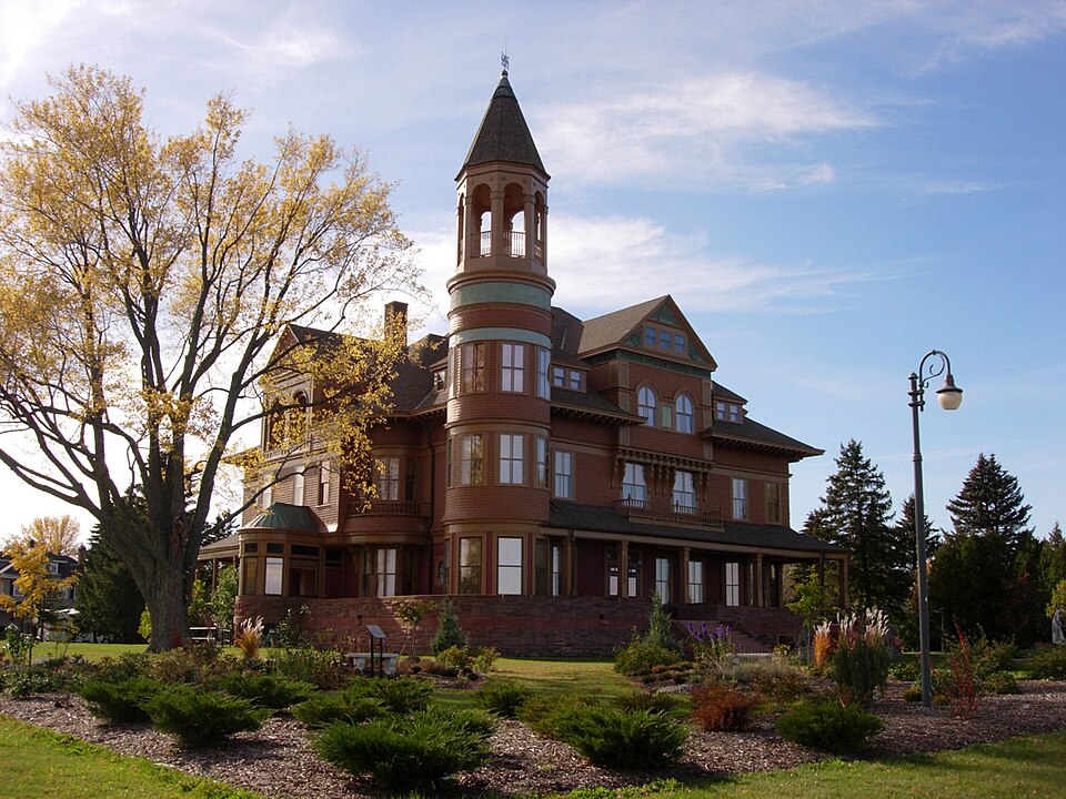
Photograph of Fairlawn Mansion
Photograph by Nfarmakes, CC BY-SA 4.0. Via Wikimedia Commons.

Martin Pattison House

Listed on the National Register of Historic Places in 1981.

From the record

“Fairlawn Mansion is a 4-story, 42 room Victorian House in Superior, Wisconsin. The mansion was built as a residence for former three-time mayor of Superior and lumber baron, Martin Pattison and his family.”

Wikipedia article Fairlawn Mansion, CC BY-SA 4.0.

One of 20 National Register listings published here for Douglas County · listed in 1981 · category: Building.

Sources: the Wikipedia article · the case file at the National Archives · the National Register database, National Park Service

The listing

  • What is counted as historic. The nomination lists 1 building as contributing to the listing.
  • Listed as. Pattison, Martin, House - the National Register files a house under its owner's surname.
  • Address. 906 E. 2nd St., Superior, 54880
  • When was it listed? February 1981
  • Category. building
  • City. Superior city
  • Architectural style. Queen Anne style architecture in the United States
  • National Register reference number. 81000042 - the number the National Park Service assigned this property when it was listed, and the key its nomination file is catalogued under at the National Archives.

Fires near this property

27 since 1992

Regional context, not property-specific evidence. The federal wildfire occurrence database lists 27 fires within 5 miles of Martin Pattison House between 1992 and 2020, burning about 65 acres in total. 1 started naturally. 2 were recorded as arson. Distance is straight-line from the map coordinates, so a fire counted here may appear on a neighbouring settlement's page as well.

Reported cause Fires
Debris and open burning8
Missing data/not specified/undetermined5
Equipment and vehicle use4
Recreation and ceremony3
Fireworks2
Arson/incendiarism2
Smoking1
Power generation/transmission/distribution1
Natural1

The most recent of them, most recent first, with the day each was reported and the service that recorded it.

DateCause SizeReported by Name on the report
9 September 2005Debris and open burningunder an acreWisconsin Department of Natural Resourcesnot named
18 August 2019Debris and open burningunder an acreMinnesota Department of Natural Resourcesnot named
17 August 2019Debris and open burningunder an acreMinnesota Department of Natural Resourcesnot named
4 July 2017Fireworksunder an acreMinnesota Department of Natural Resourcesnot named
23 July 2019Recreation and ceremonyunder an acreMinnesota Department of Natural Resourcesnot named
5 June 2017Debris and open burningunder an acreMinnesota Department of Natural Resourcesnot named
26 June 2020Recreation and ceremonyunder an acreMinnesota Department of Natural Resourcesnot named
13 June 2017Naturalunder an acreMinnesota Department of Natural Resourcesnot named

Every fire recorded in Douglas County

Mines and quarries near this property

8 within 5 miles

Regional context, not property-specific evidence. The federal mineral resources record lists 8 workings within 5 miles of Martin Pattison House: 4 plants, 3 producers, 1 unknown. 7 still produce. What was taken out: Sand and Gravel, Construction, Stone, Crushed/Broken, Sulfur. Distance is straight-line from the map coordinates, so a quarry counted here may appear on a neighbouring settlement's page as well.

Where SiteCommodity StatusRecorded
(Facility) Superior Refinery--Murphy Oil CoSulfurPlant
Smith QuarryStone, Crushed/BrokenProducer
Superior Grinding PlantStone, Crushed/BrokenPlant
Superior Lime PlantStone, Crushed/BrokenPlant
Albany Crushing PlantSand and Gravel, ConstructionProducer
Albany Crushing Plant PlantSand and Gravel, ConstructionPlant
Mailing PitSand and Gravel, ConstructionProducer
Mclean DredgeSand and Gravel, ConstructionUnknown

Every working recorded in Douglas County

Storms near this property

51 since 1994

Regional context, not property-specific evidence. The National Weather Service names Superior, the town this property stands in, in 51 storm reports between 1994 and 2024: 29 thunderstorm wind, 17 hail, 4 lightning, 1 tornado. No death or injury is recorded in these reports. Each account below is quoted exactly as the forecast office filed it, from the NOAA Storm Events Database, and each date opens the federal record of that event.

WhenEvent Place namedHarm What the report says
August 2005LightningSuperior$60,000Lightning struck a wood pile at Johnson Timber Corporation woodyard, causing the wood to catch fire. Four hundred cords of wood were destroyed.
March 2000LightningSuperior$15,000Lightning struck a home and started a fire on the second floor. No one was injured.
July 1995Thunderstorm WindSuperior$5,000Trees 50-60 feet high were blown down on a house.
June 2010Thunderstorm WindSuperior$3,000A half dozen 6-inch diameter trees were blown down on County Road A near the Nemadji Golf Course.
August 2023Thunderstorm WindSouth Superior$2,000Trees and fence panels were blown down.
August 2023Thunderstorm WindSouth Superior$1,000Fence panels were broken by winds and then blown into a window during the storm.
September 1999LightningSuperior$500no account filed
July 2024Thunderstorm WindSuperior-An 18 to 24 inch diameter silver maple tree was snapped about 8 feet up in front of the old library.
June 2024Thunderstorm WindSouth Superior-A photo was received showing an uprooted tree about 2 feet in diameter on the ground in the Village of Superior near highways 105 and 35.
July 2021Thunderstorm WindSuperior-A gust of 62 mph was recorded by the MnDOT RWIS station MN081 just south of the main span of the Blatnik Bridge over the St. Louis River.
July 2021Thunderstorm WindSuperior-Multiple reports of trees down were received from around Superior.
August 2020Thunderstorm WindSuperior-A large tree was downed by the storm in Superior.
August 2020Thunderstorm WindSuperior-A large tree was uprooted near Superior City Hall. Several other reports of downed trees and branches were received from the central part of Superior as well.
August 2020Thunderstorm WindSuperior-The roof of a large industrial building on the far north end of Superior on the waterfront was severely damaged and partially blown off.
September 2018Thunderstorm WindSuperior-A 12 inch diameter 40 foot tall pine tree was blown down onto a deck.
June 2016Thunderstorm WindSuperior-A large tree was knocked down and damaged a house and fence.
July 2016Thunderstorm WindSuperior-There was a large tree down along Belknap Street.
July 2016Thunderstorm WindSuperior-Two docks on Barker Island were damaged.
June 2015HailSuperior-The hail fell in the Billings Park neighborhood of Superior, WI.
August 2012Tornado (EF0)Superior-A weak waterspout made landfall as a brief tornado at Bakers Island. There was no damage.
May 2009HailSuperior-The hail fell near the Mariner Mall.
August 2008HailSuperior-The hail was reported near the mouth of the Nemadji River.
June 2007Thunderstorm WindSuperior-Large trees were blown down and windows of a house were shattered by strong thunderstorm winds.
September 2007HailSuperior-Penny sized hail.
May 2007HailSuperior-The hail fell at the UW Superior campus.
June 2005Thunderstorm WindSuperior-Power was lost when trees fell on power lines.
August 2005Thunderstorm WindSuperior-Trees were blown down on Wisconsin Point.
July 2003Thunderstorm WindSuperior-Trees were blown down in the Billings Park area.
August 2001Thunderstorm WindSuperior-Strong winds ripped the roof off a house trailer.
August 2000Thunderstorm WindSuperior-Trees from 8 to 10 inches in diameter were blown down. Wind speed is estimated.
July 1995Thunderstorm WindSuperior-Many trees were blown down.
July 1994HailSuperior-A powerful tornado cut a short but devasting path in northern Manitowoc County from two and one-half miles northwest of Maribel to near Cooperstown. A second smaller tornado also developed two miles southwest of Cooperstown and carved out a minor damage path leveling a shed and tossing a grain box about 300 yards. Much of the $2.1 million damage inflicted by the first tornado included 26 homes, $906,000; 19 vehicles and one mobile home, $300,000; household contents, $245,000; three barns, $160,000; Wisconsin Public Service property, $50,000; crops, $304,800; and four heifers and two sheep killed, $3,600. One man was injured when he was struck by a 55 gallon drum, and a woman suffered minor injuries when pieces of a stone foundation fell on her. A severe thunderstorm dropped one inch diameter hail in Superior (Douglas County).
July 2023HailSuperior-no account filed
June 2021HailSuperior-no account filed
July 2021HailSuperior-no account filed
May 2012HailSuperior-no account filed
September 2011HailSuperior-no account filed
June 2010HailSuperior-no account filed
August 2008HailSuperior-no account filed
July 2006HailSuperior-no account filed
April 2004HailSuperior-no account filed
August 2003Thunderstorm WindSuperior-no account filed
August 2002HailSuperior-no account filed
July 2002Thunderstorm WindSuperior-no account filed
August 2000Thunderstorm WindSuperior-no account filed
July 1999Thunderstorm WindSuperior-no account filed
June 1999Thunderstorm WindSuperior-no account filed
August 1998HailSuperior-no account filed
August 1996LightningSuperior-no account filed
July 1996Thunderstorm WindSuperior-no account filed

Every storm recorded in Douglas County

Map coverage status

No historic map-sheet match is published for this property yet. That does not mean no map exists. This record needs a coordinate-quality review before it can be joined to a sheet boundary. Browse the county's mapped places while that work is pending.

Listed places nearby

6 within 8 miles

Other National Register properties close enough to walk or drive between, ordered by distance from this one. Both positions come from the same geocoding pass that matched these properties to their map sheets.

Photograph PropertyDistance Listed
METEOR (Whaleback carrier)0.4 miles1974
Northern Block1.2 miles1985
Douglas County Courthouse1.6 miles1982
Trade and Commerce Building1.8 miles1979
Roosevelt Terrace1.9 miles2005
New Jersey Building1.9 miles1983

Sources for this property

National Archives recordThe nomination case file for reference 81000042 in Record Group 79.
Wikipedia articleCommunity-written account of this property, licensed CC BY-SA.
Douglas CountyAll 20 listed properties in this county.

Provenance

  • Listing record. National Park Service National Register of Historic Places, listed-properties dataset, current to 2026-05-22.
  • Map join. Address geocoded through the United States Census geocoder, then tested against the published boundary of every sheet in the USGS Historical Topographic Map Collection.
  • How this page is made. Listing fields come from federal records; map-sheet coverage is a labelled coordinate-to-boundary calculation, not a source-field claim.
  • Wildfire. Short, Karen C. 2022. Spatial wildfire occurrence data for the United States, 1992-2020 [FPA_FOD_20221014]. 6th Edition. Fort Collins, CO: Forest Service Research Data Archive. https://doi.org/10.2737/RDS-2013-0009.6 Collected with United States Government funding and usable without additional permissions or fees.
  • Mines and quarries. USGS Mineral Resources Data System (MRDS) https://mrdata.usgs.gov/mrds/ A work of the United States government, no copyright under 17 U.S.C. 105.
  • Storms. NOAA National Centers for Environmental Information, Storm Events Database https://www.ncei.noaa.gov/stormevents/ A work of the United States government, no copyright under 17 U.S.C. 105. Narratives are quoted verbatim from the National Weather Service report and are not edited or summarised.