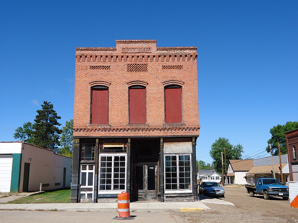
Built in 1896. Listed on the National Register of Historic Places in 1982.
From the record
“The California Wine and Liquor Store is located in Fairchild, Wisconsin. It was listed on the National Register of Historic Places in 1982 and on the State Register of Historic Places in 1989.”
Wikipedia article California Wine and Liquor Store, CC BY-SA 4.0.
One of 66 National Register listings published here for Eau Claire County · listed in 1982 · category: Building · built in 1896.
National Register reference number.82000666- the number the National Park Service assigned this property when it was listed, and the key its nomination file is catalogued under at the National Archives.
Tile village ol Fairchild is located in the exti-eme southeast corner of the county and township, and was settled in 1868, about the time when the then West Wisconsin railway was constructing its road-bed. The line was opened for traffic in 1870. The land was at this time covered with a low growth of bushes. One of the first settlers there was Mr. Van Auken. He built the first steam sawmill and sold it to another early settler, G. S. Graves, in 1870. It was twice burned down, the second time in 1874, and not rebuilt. The McKinney house, the first hotel, was erected in 1878, and operated by Samuel McKinney. The other hotel, the Fairchild house, was built by Nathaniel C. Foster in 1875.
One of the first structures erected here was the Methodist Episcopal church. This occurred in 1874. For several years previous to this time the itinerant preachers of this denomination had conducted services in this locality. It was included in the Fairchild and Ilumbird circuit. The Rev. John Holt was the first man who preached here. The meetings were held in a board shanty, the floor of which was so loose that it kept in motion while anyone walked on it. The settlers scattered around welcomed these teachers of God's word most heartily. The first regular pastor was the Rev. George Benham. This was in 1877. He had charge of this organization and the one at Humbird. His successors were the Revs. C. Barker, G. D. Brown, J. W. Wells, M. J. Robinson, R. Smith, William Gallaway, John Holt, D. Clingman, G. S. Perry, and N. R. Hiues. The church edifice was later removed to a new location and almost entirely rebuilt.
Regional context, not property-specific
evidence. The
federal wildfire occurrence database
lists 111 fires within 5 miles of California Wine and Liquor Store
between 1992 and 2020, burning about 77 acres in total. 2 started naturally. 7 were recorded as arson.
Distance is straight-line from the map coordinates, so a fire counted
here may appear on a neighbouring settlement's page as well.
Reported cause
Fires
Debris and open burning
37
Missing data/not specified/undetermined
23
Equipment and vehicle use
18
Railroad operations and maintenance
7
Arson/incendiarism
7
Other causes
6
Recreation and ceremony
5
Natural
2
Fireworks
2
Power generation/transmission/distribution
2
Misuse of fire by a minor
1
Smoking
1
The most recent of
them, most recent first, with the day each was reported and the service
that recorded it.
Regional context, not property-specific
evidence. The federal mineral resources record lists
2 workings within 5 miles of California Wine and Liquor Store: 2 past producers.
None of them still produces. What was taken out: Stone, Crushed/Broken, Sand and Gravel, Construction. Distance is straight-line from the
map coordinates, so a quarry counted here may appear on a neighbouring
settlement's page as well.
Regional context, not property-specific
evidence. The National Weather Service names
Fairchild, the town this property stands in, in 11 storm reports between 2009 and 2025: 7 hail, 2 thunderstorm wind, 2 tornado.
No death or injury is recorded in these reports. Each account below is quoted exactly as the forecast office
filed it, from the NOAA Storm Events Database, and each date
opens the federal record of that event.
A short lived tornado moved mostly along County Road M. It took part of the roof off of an outbuilding at a farm. Some shingles were also torn off the roofs of several houses. Several hundred trees were broken before it dissipated just east of County Road H. The maximum estimated wind speed was 90 mph.
No historic map-sheet match is published
for this property yet. That does not mean no map exists. This record needs
a coordinate-quality review before it can be joined to a sheet boundary.
Browse the county's mapped places while that work is
pending.
Listing record. National Park Service National Register of Historic Places, listed-properties dataset, current to 2026-05-22.
Map join. Address geocoded through the United States Census geocoder, then tested against the published boundary of every sheet in the USGS Historical Topographic Map Collection.
How this page is made. Listing fields come from federal records; map-sheet coverage is a labelled coordinate-to-boundary calculation, not a source-field claim.
Wildfire. Short, Karen C. 2022. Spatial wildfire occurrence data for the United States, 1992-2020 [FPA_FOD_20221014]. 6th Edition. Fort Collins, CO: Forest Service Research Data Archive. https://doi.org/10.2737/RDS-2013-0009.6 Collected with United States Government funding and usable without additional permissions or fees.
Mines and quarries. USGS Mineral Resources Data System (MRDS) https://mrdata.usgs.gov/mrds/ A work of the United States government, no copyright under 17 U.S.C. 105.
Storms. NOAA National Centers for Environmental Information, Storm Events Database https://www.ncei.noaa.gov/stormevents/ A work of the United States government, no copyright under 17 U.S.C. 105. Narratives are quoted verbatim from the National Weather Service report and are not edited or summarised.
 Block