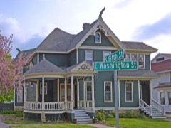
Stoughton Main Street Commercial Historic District
Listed on the National Register of Historic Places in 1982.
From the record
“The Stoughton Main Street Commercial Historic District is a collection of 36 surviving historic business structures in the old downtown of Stoughton, Wisconsin, United States. It was added to the National Register of Historic Places in 1982.”
Wikipedia article Stoughton Main Street Commercial Historic District, CC BY-SA 4.0.
One of 238 National Register listings published here for Dane County · listed in 1982 · category: District.
National Register reference number.82001842- the number the National Park Service assigned this property when it was listed, and the key its nomination file is catalogued under at the National Archives.
XICHOIiAi^ AliTEMUS, farmer, Sec. 2 ; P. 0. Stoughton ; was born in Monroe Co., Penn., in 1829; when 16 years old, he became apprenticed to the harness-maker's trade, which he followed, together with merchandising, in his native State till 1855 ; he then emigrated to Wisconsin and located on Sec. 2, town of Dunkirk, Dane Co., where he now owns 240 acres. He was married, in Monroe Co., Penn., in 1852, to Sally A. Saylor, a native of that county ; their children are Emma 0., Sarah A., Charles S., Ida D., Oscar P., Edgar D. and Theodore N. Mr. Altemus is a member of the M. E. Church.
THEODORE BAILEY, farmer. Sec. 21 ; P. 0. Stoughton; was born in Litchfield Co., Conn., May 30, 1803 ; when a year old, his parents removed with him to Steuben Co., N. Y., whence, in 1821, they went to Crawford Co., Penn., and two years later to Mercer Co., Penn., where they died; when 18 years old, he went to the town of Erie, Erie Co., Penn, and there followed teaming principally till 1842, going thence to Port Stanley, Canada; he was employed on public works till November, 1850, when he removed to Alabama and engaged in the livery-stable and staging business till the spring of 1855 ; he came then to the town of Dunkirk, Dane Co., Wis., and bought his present farm of 120 acres on Sees. 20 and 21. He was married, in April, 1834, to Nancy A., daughter of Daniel and Nancy Chidester, a native of Cooperstown, N. Y.; she died June 9, 1868, having had one son - James S., who was killed in the battle of Malvern Hill, Va.; his second marriage was celebrated Sept. 12, 1869, to Mrs. Emily Lyon, nee Warren, a native of St. Johnsbury, Vt., she having two daughters by a former marriage - Martha, now Mrs. George Burnett, of Stoughton ; Emma, Mrs. A. E. Gilbert, of Dunkirk.
Regional context, not property-specific
evidence. The
federal wildfire occurrence database
lists 18 fires within 5 miles of Stoughton Main Street Commercial Historic District
between 1994 and 2020, burning about 18 acres in total. None started naturally. 1 was recorded as arson.
Distance is straight-line from the map coordinates, so a fire counted
here may appear on a neighbouring settlement's page as well.
Reported cause
Fires
Missing data/not specified/undetermined
8
Debris and open burning
6
Arson/incendiarism
1
Recreation and ceremony
1
Other causes
1
Misuse of fire by a minor
1
The most recent of
them, most recent first, with the day each was reported and the service
that recorded it.
Regional context, not property-specific
evidence. The federal mineral resources record lists
3 workings within 5 miles of Stoughton Main Street Commercial Historic District: 2 producers, 1 unknown.
2 still produce. What was taken out: Sand and Gravel, Construction. Distance is straight-line from the
map coordinates, so a quarry counted here may appear on a neighbouring
settlement's page as well.
Regional context, not property-specific
evidence. The National Weather Service names
Stoughton, the town this property stands in, in 50 storm reports between 1994 and 2025: 28 thunderstorm wind, 14 hail, 4 funnel cloud, 3 tornado.
No death or injury is recorded in these reports. Each account below is quoted exactly as the forecast office
filed it, from the NOAA Storm Events Database, and each date
opens the federal record of that event.
This tornado moved from just west of Hults Road on the far western part of Stoughton northeast to a point northwest of the intersection of CTH B and CTH N. Based on the observed damage, it was probably a multiple-vortex tornado. In the Stoughton area, with respect to residential homes, it resulted in very minor damage to 24 homes, minor damage to 21 homes, and major damage to 3 homes. Additionally, 1 church sustained major damage, and 1 tabacco shed was destroyed. Total estimated property damage (roofs, siding, walls, windows) in the Stoughton area was $409,000. In the Civil town of Pleasant Springs, 12 homes sustained minor damage estimated at about $20,000. The starting and ending locations in Dodge County, with respect to lat/long pairs of numbers, were 42.92395/-89.25369 and 42.96431/-89.20166, respectively. DI #2 (FR12), DOD4. Maximum wind speed about 90-95 mph. Average path width about 75 yards.
Rear-flank downdraft (RFD) damage occurred south of the F3 tornado that plowed through the area just north of Stoughton (Dane Co.). Numerous large trees were uprooted or had broken large branches. Several power-lines were damaged.
A swath of straight-line wind damage of downed trees, limbs, and power lines. Some trees fell on roofs of homes. Some homes had damage to the shingles and facia. A camper was rolled. The greatest concentration of damage was on the southwest side of Stoughton.
A HAM radio operator reported trees and large branches were blown down by damaging thunderstorm wind gusts estimated to be 56 knots (65 mph) 2 miles south-southwest of Stoughton.
A trained spotter reported trees blown down by strong thunderstorm wind gusts estimated at 56 knots (65 mph) along a path from Stoughton to Deerfield. A 3-foot diameter tree fell on a truck in Stoughton. Damage amount is estimated.
A brief tornado spun up at 1322CST at a location 3.4 miles southwest of Stoughton, just northeast of the intersection of CTH A and Lake Kegonsa Rd. Only some tree and shrub damage was noted and the tornado was rated F0 with winds of 35-63 knots (40-72 mph). The parent thunderstorm eventually moved east and generated another funnel cloud southeast of Stoughton.
An advanced spotter videotaped a tornado that briefly spun up at 1755 CST, 3.3 miles east-southeast of Stoughton (Dane Co.), and dissipated at 1756 CST, 3.8 miles west-northwest of Albion (Dane Co.). The tornado's path was only a mile long and the width was about 25 yards. No damage was reported and this tornado was deemed an F0. The average path width was about 25 yards.
Scattered short lines of severe storms quickly moved northeast through south-central and southeast Wisconsin. As usual, the powerful winds in these severe storms downed many large trees, or directly damaged buildings. The Village of Walworth (Walworth County) was hit by a savage wet microburst whose violent winds and golf ball-size hail resulted in considerable property damage estimated at $40,000. Just south of Walworth a large barn had rood damage and was rotated off its foundation. A roof was torn off a Walworth home and some of its debris was carried north only to damage another homes siding and a nearby power line. Elsewhere in the Village of Walworth there was damage to sheds, fences, power poles, roofs, antennas, and flag poles. Lightning struck and injured a 60-year-old man at a Williams Bay (Walworth County) Marina. He was given CPR, treated at a local hospital, and was released. Powerful winds blew southwest of Beaver Dam (Dodge County), resulting in $20,000 in damage to power lines, large trees, skirting on nine mobile homes, and a porch on a home. Lightning struck a home in Franklin (Milwaukee County) and started a fire which did about $8,000 in damage to the roof and attic. The lightning strikes in Racine County only did minor damage to roofs on a couple homes. Elsewhere, the powerful winds generated by the severe storms also knocked down many large trees in Waterford (Racine County); Waupan and Fond cu Lac (Fond du Lac County); and near Stoughton (Dane County).
No historic map-sheet match is published
for this property yet. That does not mean no map exists. This record needs
a coordinate-quality review before it can be joined to a sheet boundary.
Browse the county's mapped places while that work is
pending.
Listed places nearby
6 within 8 miles
Other National Register properties close
enough to walk or drive between, ordered by distance from this one. Both
positions come from the same geocoding pass that matched these properties
to their map sheets.
Listing record. National Park Service National Register of Historic Places, listed-properties dataset, current to 2026-05-22.
Map join. Address geocoded through the United States Census geocoder, then tested against the published boundary of every sheet in the USGS Historical Topographic Map Collection.
How this page is made. Listing fields come from federal records; map-sheet coverage is a labelled coordinate-to-boundary calculation, not a source-field claim.
Wildfire. Short, Karen C. 2022. Spatial wildfire occurrence data for the United States, 1992-2020 [FPA_FOD_20221014]. 6th Edition. Fort Collins, CO: Forest Service Research Data Archive. https://doi.org/10.2737/RDS-2013-0009.6 Collected with United States Government funding and usable without additional permissions or fees.
Mines and quarries. USGS Mineral Resources Data System (MRDS) https://mrdata.usgs.gov/mrds/ A work of the United States government, no copyright under 17 U.S.C. 105.
Storms. NOAA National Centers for Environmental Information, Storm Events Database https://www.ncei.noaa.gov/stormevents/ A work of the United States government, no copyright under 17 U.S.C. 105. Narratives are quoted verbatim from the National Weather Service report and are not edited or summarised.
 Block