 Block
From the record
One of 66 National Register listings published here for Eau Claire County · listed in 1983 · category: Building.
Sources: the case file at the National Archives · the National Register database, National Park Service

Listed on the National Register of Historic Places in 1983.
One of 66 National Register listings published here for Eau Claire County · listed in 1983 · category: Building.
Sources: the case file at the National Archives · the National Register database, National Park Service
The chapter on Eau Claire City in History of Eau Claire County, Wisconsin, Past and Present; Including an Account of the Cities, Towns and Villages of the County, published 1914 names Eau Claire. This is what it says, exactly as the scans read.
In March, 1872, the residents of Eaii Claire obtained a charter fi'om the legislature whereby the villages became a city. It is picturesquely situated in the valley of the Chippewa river, and is x)rotected on the northeast side and northwest by two ranges of hills, or series of bluffs, through which the river runs. Directly in front of them, and due north, is Mount Simon, the highest of the hills. On the south is a sweeping range of bluffs, which turn to the southeast, and, turning again due east, form the southern bank of the Eau Claire river, with Mount Agnes in the southeast corner and Mount Tom due east. West of Half Moon lake is another range of bluffs, so that the city is surrounded by hills, except at the inlet and outlet of the Chippewa river. The cit.y is well watered by the river named and the Half Moon lake on tile west, in the center of which is Island Park.
Passage source: History of Eau Claire County, Wisconsin, Past and Present; Including an Account of the Cities, Towns and Villages of the County, published 1914.
The city is divided into three parts, known as the North, East and West sides. They are all well laid out in streets, especially on the West side, most of which run from north to south and east to west. They are nearly all graded and aggi-egate sixty-five miles in length. The principal business thoroughfares on the East side are: Barstow, Kelsey, Eau Claire, Gibson and J\iver streets. On the North side : North Barstow, Galloway, ;\Iadison and Wisconsin streets. On the West side : Water, Bridge, Bellinger and Meuomonie streets. The majority of the business houses are of brick. The leading residence streets on the East side are Farwell, State, River and Summit, Marston and Gilbert avenues. Those on the West side are : Niagara, Hudson, Lake and Bridge streets, Broatlway and Second, Third and Fourth avenues. On the North side are : Wisconsin and Galloway streets. The finest residences are on the West side and in the southern part of the East side.
Passage source: History of Eau Claire County, Wisconsin, Past and Present; Including an Account of the Cities, Towns and Villages of the County, published 1914.
Machine-read from a century-old scan, so expect the errors a machine makes: misspelled names, dropped words, stray characters.
Read the whole chapter on Eau Claire City - 2,467 words on its settlement, mills, schools and churches.
Regional context, not property-specific evidence. The federal wildfire occurrence database lists 40 fires within 5 miles of City Hall between 1994 and 2020, burning about 57 acres in total. None started naturally. None was recorded as arson. Distance is straight-line from the map coordinates, so a fire counted here may appear on a neighbouring settlement's page as well.
| Reported cause | Fires |
|---|---|
| Missing data/not specified/undetermined | 19 |
| Debris and open burning | 9 |
| Equipment and vehicle use | 5 |
| Smoking | 3 |
| Misuse of fire by a minor | 2 |
| Recreation and ceremony | 2 |
The most recent of them, most recent first, with the day each was reported and the service that recorded it.
| Date | Cause | Size | Reported by | Name on the report |
|---|---|---|---|---|
| 28 September 2019 | Debris and open burning | under an acre | Wisconsin Department of Natural Resources | 3070 |
| 17 September 2018 | Missing data/not specified/undetermined | 1.0 acres | Wisconsin Department of Natural Resources | 186901 |
| 14 September 2008 | Recreation and ceremony | under an acre | Wisconsin Department of Natural Resources | not named |
| 31 August 2019 | Debris and open burning | under an acre | Wisconsin Department of Natural Resources | 288 |
| 23 August 2018 | Missing data/not specified/undetermined | 1.0 acres | Wisconsin Department of Natural Resources | 186221 |
| 8 July 2018 | Missing data/not specified/undetermined | under an acre | Wisconsin Department of Natural Resources | 580 |
| 7 July 2019 | Missing data/not specified/undetermined | 1.0 acres | Wisconsin Department of Natural Resources | 195158 |
| 7 July 2018 | Smoking | 1.0 acres | Wisconsin Department of Natural Resources | 184959 |
Regional context, not property-specific evidence. The federal mineral resources record lists 13 workings within 5 miles of City Hall: 6 producers, 5 unknowns, 2 past producers. 6 still produce. What was taken out: Sand and Gravel, Construction, Stone, Crushed/Broken. Distance is straight-line from the map coordinates, so a quarry counted here may appear on a neighbouring settlement's page as well.
| Where | Site | Commodity | Status | Recorded |
|---|---|---|---|---|
| Agnes Lisker Shale Quarry | Stone, Crushed/Broken | Past Producer | ||
| Old Town Road Sandstone Quarry | Stone, Crushed/Broken | Past Producer | ||
| Bloomer Pit | Sand and Gravel, Construction | Unknown | ||
| Brunswick Pit | Sand and Gravel, Construction | Unknown | ||
| Chippewa County Operations | Sand and Gravel, Construction | Unknown | ||
| Eau Claire Pit | Sand and Gravel, Construction | Producer | ||
| Eau Claire Pit | Sand and Gravel, Construction | Unknown | ||
| Kopp Pit | Sand and Gravel, Construction | Producer | ||
| Litchfield Pit | Sand and Gravel, Construction | Producer | ||
| Pit Number 4 | Sand and Gravel, Construction | Producer |
Regional context, not property-specific evidence. The National Weather Service names Eau Claire, the town this property stands in, in 116 storm reports between 1993 and 2025: 52 hail, 51 thunderstorm wind, 8 flash flood, 2 lightning. The reports record 1 death and 4 injuries. Each account below is quoted exactly as the forecast office filed it, from the NOAA Storm Events Database, and each date opens the federal record of that event.
| When | Event | Place named | Harm | What the report says |
|---|---|---|---|---|
| September 2000 | Flash Flood | Eau Claire | 1 killed, 1 hurt, $3,300,000 | Motorist drove around police barricades with vehicle and driver subsequently falling into sinkhole. The Eau Claire Leader-Telegram cited 159 reports of residential damage, and 10 reports of damage to businesses in Eau Claire County. Estimated damages within the city of 1.5 million according to the Public Works director, and another 1.8 million to county property, according to Emergency Management. Rainfall totalled 7.90 inches at the Eau Claire airport, while the NWS cooperative observer 3 miles southwest of Eau Claire measured 5.83 inches rainfall. |
| June 2016 | Thunderstorm Wind | Eau Claire | 1 hurt, $100,000 | Multiple trees were blown down across the city of Eau Claire. it affected the Blue Ox Festival where trees fell on cars and camper trailers. One person was injured by a fallen tree at the festival. |
| July 2019 | Thunderstorm Wind | Eau Claire | 1 hurt | A large tree was uprooted and landed on a camper. An individual inside the camper was injured. |
| August 2005 | Lightning | Eau Claire | 1 hurt | A 54-year-old man was struck by lightning on Menomonie Street while unhooking a chain from a truck at a business. He was transported to a local hospital for observation after "feeling hot", but was otherwise uninjured. |
| September 2016 | Flash Flood | Eau Claire | $660,000 | Widespread flooding occurred in the city of Eau Claire. 45 homes and businesses sustained minor damage, and 5 sustained major damage due to the flood waters. In addition, a mudslide occurred near Highway 53, on the north side of Eau Claire. Total damages were estimated at $300,000 in the private sector, and $360,000 in the public sector for roads, bridges, and trails infrastructure. |
| May 1996 | Thunderstorm Wind | Eau Claire | $500,000 | no account filed |
| May 1998 | Thunderstorm Wind | Eau Claire | $467,000 | Damage estimate for entire county. |
| May 2012 | Thunderstorm Wind | Eau Claire | $250,000 | Widespread tree and power line damage occurred in the northwest side of Eau Claire. A trained spotter in his truck had severe straight line winds move it approximately four feet. The hardest hit area was around Carson Park and the Lakeview Cemetery where over 2000 soft and hardwood healthy trees were blown down. There were some residential areas that were affected by fallen trees and other debris which damaged their homes and cars. Plus, a 200 foot radio tower was blown down. |
| July 2006 | Flash Flood | Eau Claire | $250,000 | Cars stalled in one to two feet of water between Eau Claire and Altoona near Fairfax street. Boat floated off of trailer. Portion of one thousand foot storm sewer pipe near UW-Eau Claire collapsed. |
| June 2015 | Lightning | Eau Claire | $108,000 | During the early morning hours of Monday, June 8th, lightning struck a home in Eau Claire, Wisconsin. It caused extensive damage, but no one was hurt. |
| June 2019 | Thunderstorm Wind | Eau Claire | $100,000 | Several pictures from social media showed large trees blown down from the University of Wisconsin, Eau Claire campus, south and east across the southern part of the city. A few trees landed on homes and caused damage to their roofs. |
| July 2015 | Thunderstorm Wind | Eau Claire | $100,000 | Several large trees were blown down in Eau Claire, causing roof damage to a few homes. |
| May 1998 | Thunderstorm Wind | Eau Claire | $73,000 | Trees and power lines down. Estimated windspeed. Damage estimate for entire county. |
| May 2020 | Thunderstorm Wind | Eau Claire | $50,000 | Spotters reported several trees down, and there was a picture of a large tree uprooted south of North High School in Eau Claire. Other damage was noted to the high school tennis court fence that was blown down. Other small trees and limbs were blown down around the vicinity of the high school. |
| June 2013 | Flash Flood | Eau Claire | $50,000 | Very heavy rainfall in a short period of time caused a mudslide on Highway 53 just south of the Eau Claire/Chippewa county line. The southbound lanes were closed for about three hours as crews removed more than 30 truckloads of soil. |
| June 2013 | Flash Flood | Eau Claire | $50,000 | Significant street flooding occurred in the City of Eau Claire. Several cars stalled as they tried to move across flooded roadways. |
| July 1994 | Thunderstorm Wind | Eau Claire | $50,000 | no account filed |
| July 2014 | Hail | Eau Claire | $25,000 | Large hail damaged a few cars in Eau Claire. |
| August 1993 | Thunderstorm Wind | Eau Claire | $5,000 | no account filed |
| July 2021 | Thunderstorm Wind | Eau Claire | $3,000 | A few trees were blown down in the City of Eau Claire. |
| May 2025 | Hail | Eau Claire | - | Several reports of large hail fell near US-35 between Eau Claire and Altoona. The largest report was up to 4 inches in diameter. There was also a report of damage to siding due to the large hail. |
| May 2025 | Hail | Eau Claire | - | Multiple reports of hail on the northeast side of Eau Claire along North Crossing. The largest report was up to 2.25 inches in diameter. |
| July 2025 | Thunderstorm Wind | Eau Claire | - | About one dozen trees across roads in various parts of Eau Claire. Some power lines also down. |
| August 2024 | Thunderstorm Wind | Eau Claire | - | Wind broke a window on the west side of a home. |
| August 2024 | Thunderstorm Wind | Eau Claire | - | County Dispatch reported numerous trees and powerlines down in SW Eau Claire. |
| July 2023 | Thunderstorm Wind | Eau Claire | - | A 12-18 inch diameter tree fell onto an unaccupied car. The report was received through a photo on social media. |
| August 2022 | Thunderstorm Wind | Eau Claire | - | A large tree was blown down in North Eau Claire. Other trees of various sizes also blew down on the north side of Eau Claire. |
| August 2021 | Heavy Rain | Eau Claire | - | There was a measured rainfall total of 6.52 inches in the city of Eau Claire that most fell in a 2 hour period. |
| August 2021 | Heavy Rain | Eau Claire | - | There was another observed rainfall report of 5.26 inches that fell in the city of Eau Claire. Most of that rainfall total happened in a 2 hour period. |
| August 2021 | Flash Flood | Eau Claire | - | There was 1 to 2 feet of water at the intersection of Eddy Lane and Abbie Hill Drive. A few cars stalled out in this intersection. In addition, there were a few residential areas that had flooded basements due to the flood waters. |
| May 2018 | Thunderstorm Wind | Eau Claire | - | A tree was blown down west of Eau Claire, near Fishermans Park. |
| August 2018 | Thunderstorm Wind | Eau Claire | - | Numerous large tree limbs were blown down across the south side of Eau Claire. |
| June 2016 | Thunderstorm Wind | Eau Claire | - | A large tree was blown down west of Eau Claire. |
| July 2015 | Thunderstorm Wind | Eau Claire | - | Power lines were blown down in Eau Claire. |
| June 2012 | Thunderstorm Wind | Eau Claire | - | A few power lines were blown down in Eau Claire. |
| June 2011 | Flash Flood | Eau Claire | - | Significant street flooding occurred around the city of Eau Claire, Wisconsin, due to rainfall amounts of four inches in less than two hours. In addition, a three-foot wide mud slide occurred near Mile Marker 63, on Interstate 94 near Eau Claire. It caused portions of the interstate to shut down until the debris was cleared. |
| July 2011 | Thunderstorm Wind | Eau Claire | - | A few trees were blown down. |
| July 2011 | Thunderstorm Wind | Eau Claire | - | A thunderstorm downburst caused a portion of a home's roof to blow off near Eau Claire, Wisconsin. |
| August 2010 | Flash Flood | Eau Claire | - | Major street flooding was reported on Hastings Way, and Valmont Avenue in Eau Claire, Wisconsin, which was observed to have over 8 inches of water across the road. |
| July 2010 | Thunderstorm Wind | Eau Claire | - | An 18 inch diameter tree was uprooted in Eau Claire, Wisconsin. |
| September 2010 | Flood | Eau Claire | - | County Emergency Management reports 6 homes in the Altoona area had basement flooding. |
| May 2008 | Hail | Eau Claire | - | Occurred at intersection of Lowes Creek road and County road HH. |
| July 2007 | Hail | Eau Claire | - | Hail fell on west side of city. |
| July 2007 | Thunderstorm Wind | Eau Claire | - | Large tree fell over roadway blocking traffic. |
| July 2007 | Thunderstorm Wind | Eau Claire | - | Tree toppled. |
| July 2006 | Thunderstorm Wind | Eau Claire | - | Scattered power lines and telephone lines felled from 3 miles west of Eau Claire to the northwest portion of town. |
| July 2006 | Hail | Eau Claire | - | Most hail reports came from the western portion of the city. |
| June 2005 | Thunderstorm Wind | Eau Claire | - | Several power lines were downed. A 6 inch diameter tree limb fell onto a truck. |
| June 2005 | Hail | Eau Claire | - | Golf ball sized hail fell at the intersection of Interstate 94 and Highway 12 about 2 miles west of Eau Claire. |
| June 2005 | Thunderstorm Wind | Eau Claire | - | A wind gust of 60 MPH was reported by a trained spotter. Large branches were downed. |
| July 2005 | Hail | Eau Claire | - | Half dollar sized hail fell on London Road. Quarter sized hail was reported elsewhere in town. |
| July 2005 | Thunderstorm Wind | Eau Claire | - | Winds estimated by law enforcement at 60 MPH downed trees. |
| June 2005 | Thunderstorm Wind | Eau Claire | - | Trees and large limbs were downed. |
| July 2004 | Thunderstorm Wind | Eau Claire | - | A tree was downed onto a roof. The time was estimated. |
| July 2002 | Thunderstorm Wind | Eau Claire | - | Scattered trees down. |
| July 2002 | Thunderstorm Wind | Eau Claire | - | Trees and large branches down. |
| June 2001 | Thunderstorm Wind | Eau Claire | - | Several trees felled. |
| June 2001 | Thunderstorm Wind | Eau Claire | - | Large tree felled in Seymour Township. |
| July 1999 | Thunderstorm Wind | Eau Claire | - | Several trees down. Estimated windspeed. |
| June 1999 | Thunderstorm Wind | Eau Claire | - | Estimated windspeed. |
No historic map-sheet match is published for this property yet. That does not mean no map exists. This record needs a coordinate-quality review before it can be joined to a sheet boundary. Browse the county's mapped places while that work is pending.
Other National Register properties close enough to walk or drive between, ordered by distance from this one. Both positions come from the same geocoding pass that matched these properties to their map sheets.
| Photograph | Property | Distance | Listed |
|---|---|---|---|
 | Eau Claire Public Library | under 500 feet | 1983 |
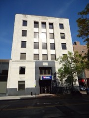 | Union National Bank | under 500 feet | 1983 |
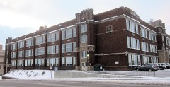 | Eau Claire High School | under 500 feet | 1983 |
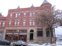 | Confluence Commercial Historic District | under 500 feet | 2007 |
| Kline's Department Store | 0.1 miles | 1984 | |
 | Eau Claire Masonic Temple | 0.1 miles | 2007 |
| National Archives record | The nomination case file for reference 83003378 in Record Group 79. |
| Eau Claire County | All 66 listed properties in this county. |