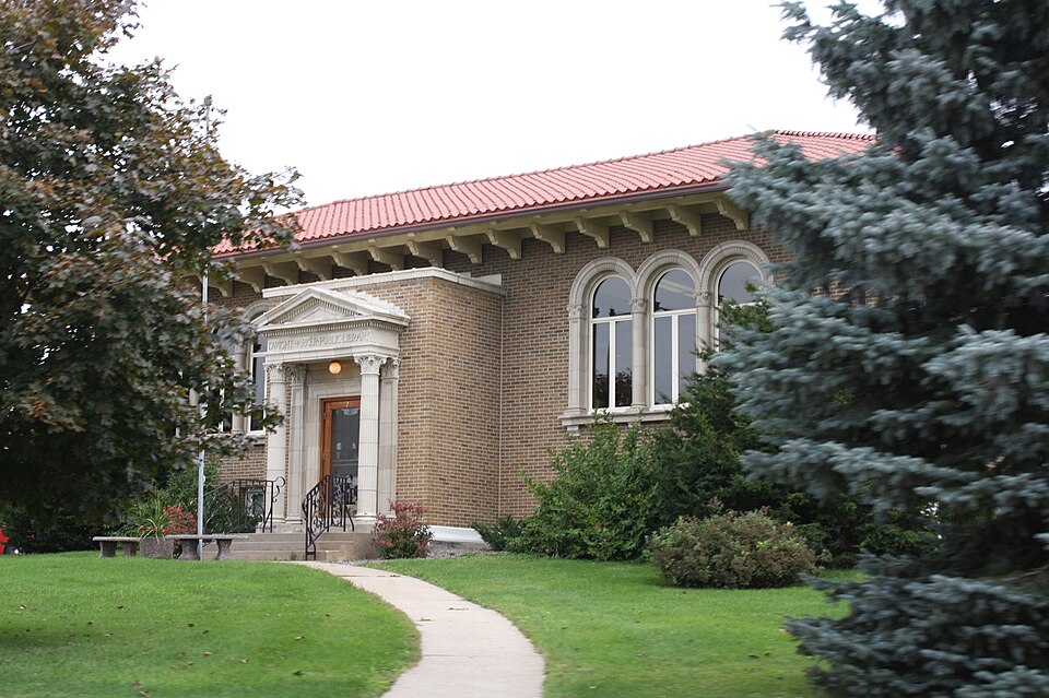
Built in 1923 (Mediterranean Revival architecture). Listed on the National Register of Historic Places in 1983.
From the record
“Parker Public Library is a public library in Fennimore, Wisconsin. The building was constructed in 1923 to house the city's library, which had previously been based in a Methodist church and the Old Fennimore House.”
Wikipedia article Dwight T. Parker Public Library, CC BY-SA 4.0.
One of 36 National Register listings published here for Grant County · listed in 1983 · category: Building · built in 1923, Mediterranean Revival architecture, by Claude and Starck.
National Register reference number.83003398- the number the National Park Service assigned this property when it was listed, and the key its nomination file is catalogued under at the National Archives.
This town owes its name to a settler, who, at the time of the breaking-out of the Black Hawk war, was living on Section 22, Town 6, Range 2 west of the Fourth Principal Meridian. He disappeared during this struggle and was not again heard from. In 1837, a Mr. Palmer settled on Fennimore's old claim, but left after remaining a short time. In 1838, John Robinson, Sr., settled on Section 34, Town 6, Range 2. John Switzer, John Dillon, John McReynolds and Henry Meeker settled in the year 1843. The first German settlers were Sigmund Stuart, who came in 1845, and John Nauert and George Bohl, who arrived in 1846. The organization of the town of Fennimore took place in 1849, embracing at that time the territory of the present towns of Fennimore, Marion, Hickory Grove, Woodman, Boscobel, Waterstown and part of Muscoda. The first town meeting was held on the 3d day of April, 1849, on Section 7, Town 6, Range 2 west, and the following officers elected : Supervisor, Lester Pratt, M. D., Chairman. Solomon C. Peckham and John Switzer ; Clerk, John A. Shearer ; Assessor, H. A. W. McNair ; Treasurer. Philo A. Dempsey ; Superintendent of Schools, John A. Shearer ; Justice of the Peace, Charles W. Loney ; Constable, Robert Munns. Chester Pratt, as Chairman, in 1849 received $10 for his services, and H. A. W. McNair, as Assessor, who had to tramp all over the above designated territory, $9.
At the present date, Fennimore embraces Township 6, Range 2, and Township 6, Range 3. The first Justice of the Peace, James Russell, was appointed by the Governor of the Territory. The first elected by the people was Charles W. Loney, elected as above. The first religious organization was formed in 1844 by Rev. Elder Allen, the class consisting of three - John Switzer, Philo Dempsey and Mrs. Dempsey. The first marriage celebrated was that of Elijah Goodrich and Allemina Russell, in 1817, the magistrate performing the ceremony being Justice Russell, nicknamed the " Chief Justice."
Regional context, not property-specific
evidence. The
federal wildfire occurrence database
lists 12 fires within 5 miles of Dwight T. Parker Public Library
between 1992 and 2020, burning about 48 acres in total. None started naturally. None was recorded as arson.
Distance is straight-line from the map coordinates, so a fire counted
here may appear on a neighbouring settlement's page as well.
Reported cause
Fires
Debris and open burning
7
Missing data/not specified/undetermined
3
Equipment and vehicle use
2
The most recent of
them, most recent first, with the day each was reported and the service
that recorded it.
Regional context, not property-specific
evidence. The federal mineral resources record lists
2 workings within 5 miles of Dwight T. Parker Public Library: 1 past producer, 1 producer.
1 still produces. What was taken out: Stone, Crushed/Broken. Distance is straight-line from the
map coordinates, so a quarry counted here may appear on a neighbouring
settlement's page as well.
Regional context, not property-specific
evidence. The National Weather Service names
Fennimore, the town this property stands in, in 38 storm reports between 1994 and 2023: 18 hail, 13 thunderstorm wind, 3 heavy rain, 2 tornado.
No death or injury is recorded in these reports. Each account below is quoted exactly as the forecast office
filed it, from the NOAA Storm Events Database, and each date
opens the federal record of that event.
A tornado touched down 2 miles northeast of Fennimore and skipped along an east path to 3 miles northwest of Montfort. The tornado damaged several mature hardwood trees, several outbuildings and three homes. On one farm alone, eight buildings were destroyed. The homes sustained minor damage compared to the hardwood trees and outbuildings. The tornado was rated an EF1 with maximum estimated winds of 110 mph. Total path length was 8.2 miles and the maximum width of the tornado was 600 yards.
An EF-0 tornado touched down outside of Fennimore along Golf Road. The tornado was on the ground for approximately two minutes and damaged a machine shed, barn, trees and blew windows out of a house.
A lightning strike started a small fire on the roof of the Fennimore elementary school. The fire was extinguished before it reached the interior of the school. The start of school was delayed for two hours.
No historic map-sheet match is published
for this property yet. That does not mean no map exists. This record needs
a coordinate-quality review before it can be joined to a sheet boundary.
Browse the county's mapped places while that work is
pending.
Listing record. National Park Service National Register of Historic Places, listed-properties dataset, current to 2026-05-22.
Map join. Address geocoded through the United States Census geocoder, then tested against the published boundary of every sheet in the USGS Historical Topographic Map Collection.
How this page is made. Listing fields come from federal records; map-sheet coverage is a labelled coordinate-to-boundary calculation, not a source-field claim.
Wildfire. Short, Karen C. 2022. Spatial wildfire occurrence data for the United States, 1992-2020 [FPA_FOD_20221014]. 6th Edition. Fort Collins, CO: Forest Service Research Data Archive. https://doi.org/10.2737/RDS-2013-0009.6 Collected with United States Government funding and usable without additional permissions or fees.
Mines and quarries. USGS Mineral Resources Data System (MRDS) https://mrdata.usgs.gov/mrds/ A work of the United States government, no copyright under 17 U.S.C. 105.
Storms. NOAA National Centers for Environmental Information, Storm Events Database https://www.ncei.noaa.gov/stormevents/ A work of the United States government, no copyright under 17 U.S.C. 105. Narratives are quoted verbatim from the National Weather Service report and are not edited or summarised.
 Block