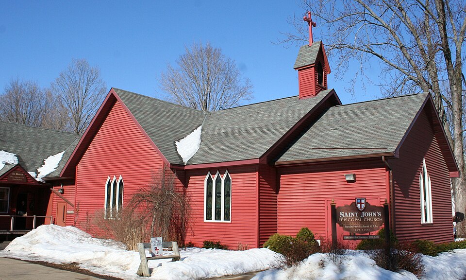
Built in 1863 (Gothic Revival). Listed on the National Register of Historic Places in 1983.
From the record
“John's Episcopal Church is located in Sparta, Wisconsin. It was added to the National Register of Historic Places in 1983 for its architectural significance.”
Wikipedia article St. John's Episcopal Church (Sparta, Wisconsin), CC BY-SA 4.0.
One of 13 National Register listings published here for Monroe County · listed in 1983 · category: Building · built in 1863, Gothic Revival.
National Register reference number.83003406- the number the National Park Service assigned this property when it was listed, and the key its nomination file is catalogued under at the National Archives.
Fires near this property
64 since 1992
Regional context, not property-specific
evidence. The
federal wildfire occurrence database
lists 64 fires within 5 miles of St. John's Episcopal Church
between 1992 and 2020, burning about 134 acres in total. None started naturally. None was recorded as arson.
Distance is straight-line from the map coordinates, so a fire counted
here may appear on a neighbouring settlement's page as well.
Reported cause
Fires
Equipment and vehicle use
19
Debris and open burning
14
Railroad operations and maintenance
14
Missing data/not specified/undetermined
10
Power generation/transmission/distribution
3
Misuse of fire by a minor
2
Smoking
1
Fireworks
1
The most recent of
them, most recent first, with the day each was reported and the service
that recorded it.
Regional context, not property-specific
evidence. The federal mineral resources record lists
2 workings within 5 miles of St. John's Episcopal Church: 1 producer, 1 past producer.
1 still produces. What was taken out: Stone, Crushed/Broken. Distance is straight-line from the
map coordinates, so a quarry counted here may appear on a neighbouring
settlement's page as well.
Regional context, not property-specific
evidence. The National Weather Service names
Sparta, the town this property stands in, in 74 storm reports between 1996 and 2026: 37 thunderstorm wind, 25 hail, 6 flood, 4 lightning.
No death or injury is recorded in these reports. Each account below is quoted exactly as the forecast office
filed it, from the NOAA Storm Events Database, and each date
opens the federal record of that event.
Ponding of water was reported just south of Sparta, about one mile south of Interstate 90. Across the county about 10 percent of the corn crop was damaged or destroyed.
Lightning struck a garage just southwest of Sparta. The resulting fire destroyed the garage. The fire spread to a nearby house along a downed tree with the house suffering moderate fire and smoke damage.
Numerous trees were blown down in Sparta and several of these landed on houses. Part of a roof was blown off and several power lines were also blown down.
Trees and a large business sign were blown down in Sparta. A business sustained roof damage when the winds blew the shingles off the building. Around 1,600 customers lost power from downed power lines.
Lightning struck for the second time in Sparta, this time hitting the Land Conservation Building. Extensive damage occurred to the phone system, computers, printers and copiers.
Power lines and tree limbs were blown down and the high winds created some roof damage to a few buildings in Sparta. Also, a tree was blown down on top of garage causing damage to the roof.
Repeated rounds of heavy rain during the month of June contributed to the La Crosse River at Sparta to rise into flood stage during the evening hours on June 26th, cresting in minor flood stage at a height of 8.99 ft the morning of June 27th. The river then fell below flood stage later that morning on June 27th.
Runoff from rain and melting snow pushed the La Crosse River out of its banks in Sparta. The river crested around a half foot above the flood stage at 9.09 feet on March 14th.
Runoff from heavy caused flooding to occur along the La Crosse River in Sparta. The river crested just over two feet above the flood stage at 10.71 feet.
Runoff from heavy rains pushed the La Crosse River out of its banks in Sparta. The river crested almost four feet above the flood state at 12.26 feet. This was a crest of record for this site.
Dime to quarter sized hail fell and was accompanied by wind gusts of 45 to 50 mph just south of Sparta along Interstate 90 at Exit 25 for State Highway 27.
No historic map-sheet match is published
for this property yet. That does not mean no map exists. This record needs
a coordinate-quality review before it can be joined to a sheet boundary.
Browse the county's mapped places while that work is
pending.
Listed places nearby
6 within 8 miles
Other National Register properties close
enough to walk or drive between, ordered by distance from this one. Both
positions come from the same geocoding pass that matched these properties
to their map sheets.
Listing record. National Park Service National Register of Historic Places, listed-properties dataset, current to 2026-05-22.
Map join. Address geocoded through the United States Census geocoder, then tested against the published boundary of every sheet in the USGS Historical Topographic Map Collection.
How this page is made. Listing fields come from federal records; map-sheet coverage is a labelled coordinate-to-boundary calculation, not a source-field claim.
Wildfire. Short, Karen C. 2022. Spatial wildfire occurrence data for the United States, 1992-2020 [FPA_FOD_20221014]. 6th Edition. Fort Collins, CO: Forest Service Research Data Archive. https://doi.org/10.2737/RDS-2013-0009.6 Collected with United States Government funding and usable without additional permissions or fees.
Mines and quarries. USGS Mineral Resources Data System (MRDS) https://mrdata.usgs.gov/mrds/ A work of the United States government, no copyright under 17 U.S.C. 105.
Storms. NOAA National Centers for Environmental Information, Storm Events Database https://www.ncei.noaa.gov/stormevents/ A work of the United States government, no copyright under 17 U.S.C. 105. Narratives are quoted verbatim from the National Weather Service report and are not edited or summarised.
 Block