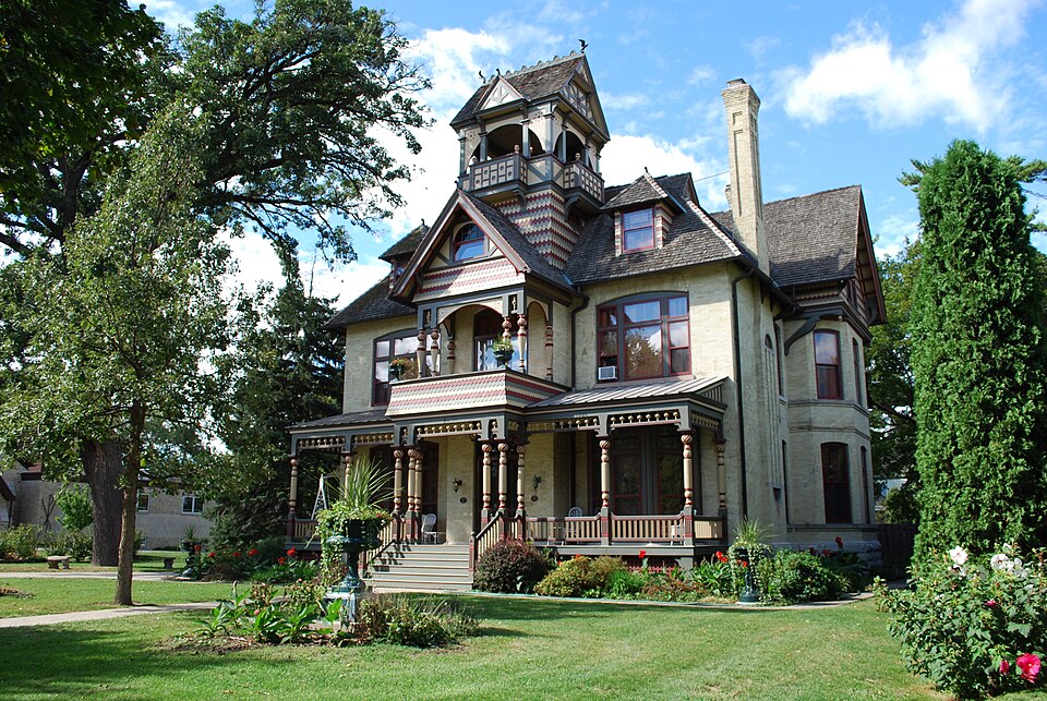
Built in 1884 (Queen Anne style). Listed on the National Register of Historic Places in 1985.
From the record
“Allyn House is a historic house located at 511 East Walworth Avenue in Delavan, Wisconsin. It was added to the National Register of Historic Places in 1985 and the State Register of Historic Places in 1989.”
Wikipedia article A. H. Allyn House, CC BY-SA 4.0.
One of 50 National Register listings published here for Walworth County · listed in 1985 · category: Building · built in 1884, Queen Anne style, by E. Townsend Mix.
National Register reference number.85001950- the number the National Park Service assigned this property when it was listed, and the key its nomination file is catalogued under at the National Archives.
The town of Delavan is one of the original towns into which the county was divided by act of the Territorial Legislature of January 2, 1838. By that act, it received its name, and, as then defined, embraced the southwestern quarter of the county, and comprised what are now the towns of Darieu, Sharon, Walworth and the present town. The original town was divided by setting of Towns No. 1, in Ranges 15 and IB east, in 1839, to which was given the name of Walworth. Subsequently, January B, 1840, Darien, lying immediately west of the present town, being Town No. 2, in Range 15 east, was set off, leaving the limits of Delavan as they now are, with the exception of a single section. No. 1, which was set off February 2, 1846, to help form the present town of Elkhorn. It was named Delavan in honor of E. C. Delavan, a prominent temperance advocate of Albany, N. Y.
The sm-face of the town is generally quite rolling, but a very small portion being flat and level. There is considerable marsh land, the greater portion of it lying in the vicinity of Delavan Lake. These marshes now constitute great natural hay meadows. Around Delavan Lake was originally a large amount of timber, mainly oak, with some hickory and a little red cedar and poplar. Extending nearly across the town, from the village of Delavan to Elkhorn, is a level tract of land known as Delavan Prairie, while in the western part is Blooming Prairie, which is smaller and of less importance.
Regional context, not property-specific
evidence. The
federal wildfire occurrence database
lists 12 fires within 5 miles of A. H. Allyn House
between 2018 and 2020, burning about 10 acres in total. 1 started naturally. None was recorded as arson.
Distance is straight-line from the map coordinates, so a fire counted
here may appear on a neighbouring settlement's page as well.
Reported cause
Fires
Debris and open burning
6
Missing data/not specified/undetermined
5
Natural
1
The most recent of
them, most recent first, with the day each was reported and the service
that recorded it.
Regional context, not property-specific
evidence. The federal mineral resources record lists
7 workings within 5 miles of A. H. Allyn House: 5 past producers, 1 producer, 1 unknown.
1 still produces. What was taken out: Sand and Gravel, Construction. Distance is straight-line from the
map coordinates, so a quarry counted here may appear on a neighbouring
settlement's page as well.
Regional context, not property-specific
evidence. The National Weather Service names
Delavan, the town this property stands in, in 44 storm reports between 1995 and 2026: 27 thunderstorm wind, 8 hail, 2 lightning, 2 flood.
The reports record 1 injury. Each account below is quoted exactly as the forecast office
filed it, from the NOAA Storm Events Database, and each date
opens the federal record of that event.
Heavy rains resulted in flash flooding across mostly the northeast part of Walworth County. Water depths on road surfaces reached 3 feet or more and there were gravel washouts. Soem roads were closed. Some farm fields remained flooded into early July. The breakdown for residential home losses were: 23 with minor damage (total of $183 thousand for home losses). There were no business losses. Crop losses were estimated at $4.254 million. Public sector damage was about $342.6 thousand. Some roads and bridges sustained damage.
Law enforcement officials reported 20 buildings were damaged and around 40 trees and numerous power lines downed by a thunderstorm microburst with wind gusts estimated at 70 mph (61 knots) along a 2 mile-long, 1/4 to 1/2 mile-wide path through the City of Delavan.
Local newspapers reported trees and power lines down in and around the town of Delavan due to damaging thunderstorm wind gusts estimated at 70 knots (80 mph). The severe wind gusts felled 40 trees and damaged roofs and gutters on buildings at Lake Lawn Resort on the northeast side of Delavan Lake.
Tornado appeared to begin along Turtle Creek west of Klug Rd and south of County Road M. The tornado destroyed an open facing barn shed along Klug Rd. It then tracked to the northeast and caused damage to 3 barns, a garage and a house along County Road P. It then continued to the northeast and crossed Dam Rd before ending near Turtle Creek again.
Numerous trees and power lines were blown down by thunderstorm wind gusts. The gusts were measured to 74 mph, with sustained winds of 59 mph, on weather equipment owned by a ham radio operator near Delavan. A television meteorologist estimated wind gusts in Lake Geneva of 52 knots.
Damage was noted to flags, a large tree limb and metal casing from a US Bank |sign. A small dumpster was also tipped behind the bank. The tornado then tracked to the west northwest through the Wileman Elementary School grounds where numerous large tree limbs were downed. Rubber roofing material on a portion of the school building was lifted and set back in place. The tornado then tracked through residences to the west northwest downing numerous limbs and a rotted/damaged tree. Gutter and roofing damage was noted on one home.
No historic map-sheet match is published
for this property yet. That does not mean no map exists. This record needs
a coordinate-quality review before it can be joined to a sheet boundary.
Browse the county's mapped places while that work is
pending.
Listed places nearby
6 within 8 miles
Other National Register properties close
enough to walk or drive between, ordered by distance from this one. Both
positions come from the same geocoding pass that matched these properties
to their map sheets.
Listing record. National Park Service National Register of Historic Places, listed-properties dataset, current to 2026-05-22.
Map join. Address geocoded through the United States Census geocoder, then tested against the published boundary of every sheet in the USGS Historical Topographic Map Collection.
How this page is made. Listing fields come from federal records; map-sheet coverage is a labelled coordinate-to-boundary calculation, not a source-field claim.
Wildfire. Short, Karen C. 2022. Spatial wildfire occurrence data for the United States, 1992-2020 [FPA_FOD_20221014]. 6th Edition. Fort Collins, CO: Forest Service Research Data Archive. https://doi.org/10.2737/RDS-2013-0009.6 Collected with United States Government funding and usable without additional permissions or fees.
Mines and quarries. USGS Mineral Resources Data System (MRDS) https://mrdata.usgs.gov/mrds/ A work of the United States government, no copyright under 17 U.S.C. 105.
Storms. NOAA National Centers for Environmental Information, Storm Events Database https://www.ncei.noaa.gov/stormevents/ A work of the United States government, no copyright under 17 U.S.C. 105. Narratives are quoted verbatim from the National Weather Service report and are not edited or summarised.
 Block