 Block
From the record
One of 85 National Register listings published here for Winnebago County · listed in 1986 · category: Building · built in 1894.
Sources: the case file at the National Archives · the National Register database, National Park Service
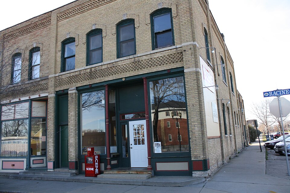
Built in 1894. Listed on the National Register of Historic Places in 1986.
One of 85 National Register listings published here for Winnebago County · listed in 1986 · category: Building · built in 1894.
Sources: the case file at the National Archives · the National Register database, National Park Service
This property stands in Menasha City. History of Winnebago County, Wisconsin, and Early History of the Northwest, published 1880 gives that township a chapter of its own.
The chapter covers the township.
Machine-read from a century-old scan, so expect the errors a machine makes: misspelled names, dropped words, stray characters.
Read the whole chapter on Menasha City - 24 words on its settlement, mills, schools and churches.
Regional context, not property-specific evidence. The federal wildfire occurrence database lists 19 fires within 5 miles of Gustav Augustin Block between 2018 and 2020, burning about 10 acres in total. None started naturally. 1 was recorded as arson. Distance is straight-line from the map coordinates, so a fire counted here may appear on a neighbouring settlement's page as well.
| Reported cause | Fires |
|---|---|
| Missing data/not specified/undetermined | 11 |
| Debris and open burning | 3 |
| Equipment and vehicle use | 2 |
| Fireworks | 1 |
| Smoking | 1 |
| Arson/incendiarism | 1 |
The most recent of them, most recent first, with the day each was reported and the service that recorded it.
| Date | Cause | Size | Reported by | Name on the report |
|---|---|---|---|---|
| 6 September 2019 | Debris and open burning | under an acre | Wisconsin Department of Natural Resources | 106 |
| 15 September 2019 | Debris and open burning | under an acre | Wisconsin Department of Natural Resources | 112 |
| 11 August 2020 | Missing data/not specified/undetermined | 1.0 acres | Wisconsin Department of Natural Resources | 1711 |
| 1 August 2018 | Missing data/not specified/undetermined | under an acre | Wisconsin Department of Natural Resources | AP00565 |
| 3 July 2020 | Missing data/not specified/undetermined | 1.0 acres | Wisconsin Department of Natural Resources | 1386 |
| 24 July 2018 | Missing data/not specified/undetermined | under an acre | Wisconsin Department of Natural Resources | 96 |
| 12 July 2018 | Fireworks | under an acre | Wisconsin Department of Natural Resources | 1485 |
| 19 June 2020 | Missing data/not specified/undetermined | under an acre | Wisconsin Department of Natural Resources | 1260 |
Regional context, not property-specific evidence. The federal mineral resources record lists 7 workings within 5 miles of Gustav Augustin Block: 3 unknowns, 2 producers, 2 past producers. 2 still produce. What was taken out: Stone, Crushed/Broken, Stone, Sand and Gravel, Construction. Distance is straight-line from the map coordinates, so a quarry counted here may appear on a neighbouring settlement's page as well.
| Where | Site | Commodity | Status | Recorded |
|---|---|---|---|---|
| Van Handel Pit | Sand and Gravel, Construction | Unknown | ||
| Deitz Quarry | Stone | Unknown | ||
| Own Crews | Stone | Unknown | ||
| Badger Highway Menasha Quarry | Stone, Crushed/Broken | Producer | ||
| Curtiss Quarry | Stone, Crushed/Broken | Past Producer | ||
| Jorgenson Quarry | Stone, Crushed/Broken | Past Producer | ||
| Schultz Quarry | Stone, Crushed/Broken | Producer |
Regional context, not property-specific evidence. The National Weather Service names Menasha, the town this property stands in, in 37 storm reports between 1998 and 2024: 19 hail, 9 thunderstorm wind, 2 tornado, 2 flood. The reports record 2 injuries. Each account below is quoted exactly as the forecast office filed it, from the NOAA Storm Events Database, and each date opens the federal record of that event.
| When | Event | Place named | Harm | What the report says |
|---|---|---|---|---|
| May 1998 | Thunderstorm Wind | Menasha | 1 hurt, $300,000 | no account filed |
| August 2004 | Lightning | Menasha | 1 hurt | no account filed |
| July 2010 | Hail | Menasha | $9,000,000 | Hail, up to golf ball size, damaged hundreds of vehicles and more than 200 homes in northeast Winnebago County. The wind-driven hail caused significant damage to roofs and siding. |
| July 2008 | Tornado (EF1) | Menasha | $75,000 | A tornado, rated EF1 with estimated wind speeds of 90 mph, touched down at 10:44 p.m. CDT about 4 miles west-northwest of Menasha. It stayed on the ground for one minute and produced sporadic damage along a narrow path almost half a mile long. An apartment complex sustained the heaviest damage. Four buildings were affected, two of which lost parts of their roofs (DI 5, DOD 2 & 3). |
| July 2011 | Thunderstorm Wind | Menasha | $50,000 | A building on the west side of Menasha was damaged by winds estimated at 75 mph. A car was flipped near Highways 76 and 10. Several camper trailers were also tipped over at a nearby campground, heavily damaging one of them. |
| July 2003 | Flash Flood | Menasha | $44,500 | no account filed |
| August 2024 | Thunderstorm Wind | Menasha | - | Thunderstorm winds downed trees and power lines in Fox Crossing. The time of this report is an estimate based on radar data. |
| June 2017 | Thunderstorm Wind | Menasha | - | Thunderstorm winds uprooted many trees in Menasha. |
| December 2015 | Heavy Rain | Menasha | - | Several rounds of heavy rain across Winnebago County resulted in water covering the road near the intersection of Highway 114 and South Oneida Street in Menasha and flooding of fields between Neenah and Oshkosh. |
| July 2015 | Thunderstorm Wind | Menasha | - | Thunderstorm winds downed tree limbs and power lines in Menasha. |
| August 2014 | Hail | Menasha | - | Nickel size hail fell at Menasha. |
| June 2012 | Hail | Menasha | - | Quarter size hail fell in Menasha. |
| May 2011 | Hail | Menasha | - | Nickel size hail fell in Menasha. |
| September 2011 | Thunderstorm Wind | Menasha | - | Thunderstorm winds snapped trees, downed power lines and tore 2 sections from a dock on the north side of Lake Winnebago. |
| July 2010 | Hail | Menasha | - | Golf ball size hail near Menasha caused extensive damage to the roof and siding of a house. |
| July 2010 | Hail | Menasha | - | Quarter to half dollar size hail fell near Menasha. |
| July 2008 | Hail | Menasha | - | Torrential rainfall accompanied the hail. |
| June 2008 | Hail | Menasha | - | Penny size hail lasted for 3 minutes. |
| August 2008 | Hail | Menasha | - | Penny size hail was reported in the town of Menasha. |
| August 2008 | Hail | Menasha | - | Quarter size hail was reported in the town of Menasha. |
| August 2008 | Hail | Menasha | - | Spotters reported half-dollar size hail on the east side of Menasha. |
| August 2008 | Hail | Menasha | - | Nickel size hail was reported on the east side of Menasha. |
| August 2008 | Hail | Menasha | - | Nickel size hail was reported in the town of Menasha. |
| July 2008 | Thunderstorm Wind | Menasha | - | Thunderstorms winds downed branches and produced half-inch hail at the intersection US Highway 441 and County Road P. |
| July 2008 | Hail | Menasha | - | Quarter size hail damaged a garden near Neenah. |
| July 2003 | Hail | Menasha | - | no account filed |
| May 2002 | Hail | Menasha | - | no account filed |
| May 2002 | Funnel Cloud | Menasha | - | no account filed |
| April 2001 | Thunderstorm Wind | Menasha | - | no account filed |
| August 2000 | Flood | Menasha | - | no account filed |
| June 1999 | Flood | Menasha | - | no account filed |
| May 1998 | Hail | Menasha | - | no account filed |
| August 1998 | Tornado (F0) | Menasha | - | no account filed |
| June 1998 | Seiche | Menasha | - | no account filed |
| August 1998 | Hail | Menasha | - | no account filed |
| August 1998 | Thunderstorm Wind | Menasha | - | no account filed |
| March 1998 | Hail | Menasha | - | no account filed |
No historic map-sheet match is published for this property yet. That does not mean no map exists. This record needs a coordinate-quality review before it can be joined to a sheet boundary. Browse the county's mapped places while that work is pending.
Other National Register properties close enough to walk or drive between, ordered by distance from this one. Both positions come from the same geocoding pass that matched these properties to their map sheets.
| Photograph | Property | Distance | Listed |
|---|---|---|---|
 | US Post Office-Menasha | under 500 feet | 1986 |
| Upper Main Street Historic District | under 500 feet | 1984 | |
 | Menasha Dam | 0.2 miles | 1993 |
| Brin Building | 0.4 miles | 1986 | |
 | Banta, George, Sr. and Ellen, House | 0.4 miles | 1997 |
| Tayco Street Bridge | 0.4 miles | 1986 |
| National Archives record | The nomination case file for reference 86001181 in Record Group 79. |
| Winnebago County | All 85 listed properties in this county. |