 Block
From the record
One of 141 National Register listings published here for Rock County · listed in 1987 · category: Building.
Sources: the case file at the National Archives · the National Register database, National Park Service
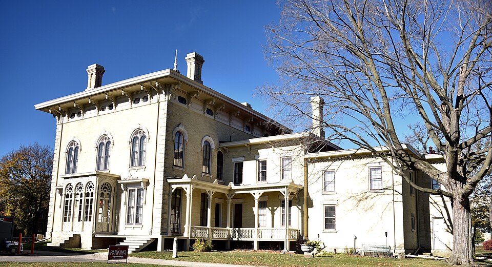
Listed on the National Register of Historic Places in 1987.
One of 141 National Register listings published here for Rock County · listed in 1987 · category: Building.
Sources: the case file at the National Archives · the National Register database, National Park Service
The chapter on Janesville City in History of Rock County, and Transactions of the Rock County Agricultural Society and Mechanics' Institute, published 1856 names Janesville. This is what it says, exactly as the scans read.
Janesville is the County Seat of Rock County. The city is beautifully located on the Rock River, nearly in the center of the county, twelve miles north of the Illinois State line, sixty-five miles west of Racine, the same distance from Milwaukee, and forty miles S. E. of Madison. Its history, so far as known, like most of the towns of the west, is comprised within a compass of twenty years. A silence rests upon the early history of this spot which the antiquarian in vain attempts to break. There are no ancient records of primeval times, no traditionary legends which carry us back to' the dreamy past, not even a national ballad to commemorate the deeds <rf the s;reat and good who here lived and died.
Passage source: History of Rock County, and Transactions of the Rock County Agricultural Society and Mechanics' Institute, published 1856.
This house was first kept by Mr. Janes, who was succeeded by Mr. Chas. Stevens, who also took charge of the ferry, which, in the mean time, had been established by Mn Janes and Aaron Walker. Mr. J. P. Dickson afterwards took charge of the public house and ferry, in which place he continued until the " Janesville Stage House ''was erected, in the fall of 1838, by Mr. Stevens, who was duly installed landlord of one of the first class public houses west of Lake MichigaUi That original building was 30 by 40 feet on the ground, and two stories in perpendicular height.
Passage source: History of Rock County, and Transactions of the Rock County Agricultural Society and Mechanics' Institute, published 1856.
Machine-read from a century-old scan, so expect the errors a machine makes: misspelled names, dropped words, stray characters.
Read the whole chapter on Janesville City - 70,689 words on its settlement, mills, schools and churches.
Regional context, not property-specific evidence. The federal wildfire occurrence database lists 11 fires within 5 miles of Payne-Craig House between 2018 and 2019, burning about 2 acres in total. None started naturally. None was recorded as arson. Distance is straight-line from the map coordinates, so a fire counted here may appear on a neighbouring settlement's page as well.
| Reported cause | Fires |
|---|---|
| Missing data/not specified/undetermined | 8 |
| Debris and open burning | 2 |
| Smoking | 1 |
The most recent of them, most recent first, with the day each was reported and the service that recorded it.
| Date | Cause | Size | Reported by | Name on the report |
|---|---|---|---|---|
| 7 August 2018 | Missing data/not specified/undetermined | under an acre | Wisconsin Department of Natural Resources | 6330 |
| 8 July 2019 | Debris and open burning | under an acre | Wisconsin Department of Natural Resources | 5344 |
| 7 July 2018 | Missing data/not specified/undetermined | under an acre | Wisconsin Department of Natural Resources | 5449 |
| 5 June 2018 | Missing data/not specified/undetermined | under an acre | Wisconsin Department of Natural Resources | 4517 |
| 29 April 2018 | Smoking | 1.0 acres | Wisconsin Department of Natural Resources | 3368 |
| 29 April 2018 | Missing data/not specified/undetermined | under an acre | Wisconsin Department of Natural Resources | 3363 |
| 23 April 2018 | Debris and open burning | under an acre | Wisconsin Department of Natural Resources | 279 |
| 13 April 2018 | Missing data/not specified/undetermined | under an acre | Wisconsin Department of Natural Resources | 2895 |
Regional context, not property-specific evidence. The federal mineral resources record lists 9 workings within 5 miles of Payne-Craig House: 4 past producers, 4 producers, 1 unknown. 4 still produce. What was taken out: Stone, Crushed/Broken, Sand and Gravel, Construction, Stone. Distance is straight-line from the map coordinates, so a quarry counted here may appear on a neighbouring settlement's page as well.
| Where | Site | Commodity | Status | Recorded |
|---|---|---|---|---|
| Bass Quarry | Stone | Unknown | ||
| Janesville Pit & Mill | Sand and Gravel, Construction | Producer | ||
| Rock County Pioneer Crusher 493 | Sand and Gravel, Construction | Producer | ||
| Wheeler Pit | Sand and Gravel, Construction | Past Producer | ||
| Austin Quarry | Stone, Crushed/Broken | Past Producer | ||
| Beaudin Quarry | Stone, Crushed/Broken | Producer | ||
| County Shop Quarry | Stone, Crushed/Broken | Past Producer | ||
| Gunn Pit | Stone, Crushed/Broken | Producer | ||
| O'Leary Quarry | Stone, Crushed/Broken | Past Producer |
Regional context, not property-specific evidence. The National Weather Service names Janesville, the town this property stands in, in 67 storm reports between 1994 and 2006: 31 thunderstorm wind, 14 hail, 12 lightning, 4 flood. The reports record 7 injuries. Each account below is quoted exactly as the forecast office filed it, from the NOAA Storm Events Database, and each date opens the federal record of that event.
| When | Event | Place named | Harm | What the report says |
|---|---|---|---|---|
| June 1998 | Lightning | Janesville | 5 hurt | no account filed |
| August 1998 | Flash Flood | Janesville | 1 hurt, $1,500,000 | no account filed |
| September 1997 | Strong Wind | Janesville | 1 hurt, $1,000 | no account filed |
| August 1998 | Flash Flood | Janesville | $550,000 | no account filed |
| May 1999 | Thunderstorm Wind | Janesville | $175,000 | no account filed |
| July 1998 | Thunderstorm Wind | Janesville | $100,000 | no account filed |
| July 1998 | Lightning | Janesville | $50,000 | no account filed |
| May 1999 | Lightning | Janesville | $40,000 | no account filed |
| May 1999 | Lightning | Janesville | $40,000 | no account filed |
| July 1999 | Lightning | Janesville | $35,000 | no account filed |
| March 2002 | Lightning | Janesville | $30,000 | no account filed |
| May 2000 | Lightning | Janesville | $25,000 | no account filed |
| August 2002 | Lightning | Janesville | $20,000 | no account filed |
| June 1995 | Thunderstorm Wind | Janesville | $20,000 | no account filed |
| June 1998 | Thunderstorm Wind | Janesville | $19,000 | no account filed |
| July 2000 | Thunderstorm Wind | Janesville | $15,000 | no account filed |
| July 2000 | Lightning | Janesville | $10,000 | no account filed |
| May 1998 | Thunderstorm Wind | Janesville | $7,000 | no account filed |
| April 1996 | Lightning | Janesville | $7,000 | no account filed |
| April 1997 | Thunderstorm Wind | Janesville | $5,000 | no account filed |
| June 1998 | Thunderstorm Wind | Janesville | $4,000 | no account filed |
| August 2002 | Lightning | Janesville | $2,500 | no account filed |
| July 1999 | Thunderstorm Wind | Janesville | $2,000 | no account filed |
| July 1999 | Thunderstorm Wind | Janesville | $1,500 | no account filed |
| June 1998 | Thunderstorm Wind | Janesville | $1,500 | no account filed |
| March 2004 | Thunderstorm Wind | Janesville | $1,000 | no account filed |
| February 1999 | Lightning | Janesville | $1,000 | no account filed |
| June 1997 | Thunderstorm Wind | Janesville | $1,000 | no account filed |
| September 1997 | Thunderstorm Wind | Janesville | $1,000 | no account filed |
| May 1998 | Thunderstorm Wind | Janesville | $500 | no account filed |
| May 2006 | Thunderstorm Wind | Janesville | - | Trees and powerlines down. |
| June 2006 | Thunderstorm Wind | Janesville | - | Trees down. |
| June 2006 | Thunderstorm Wind | Janesville | - | Widespread tree damage. |
| August 2006 | Hail | Janesville | - | no account filed |
| March 2005 | Hail | Janesville | - | no account filed |
| May 2005 | Hail | Janesville | - | no account filed |
| June 2005 | Thunderstorm Wind | Janesville | - | no account filed |
| June 2005 | Thunderstorm Wind | Janesville | - | no account filed |
| June 2005 | Thunderstorm Wind | Janesville | - | no account filed |
| June 2005 | Thunderstorm Wind | Janesville | - | no account filed |
| May 2005 | Hail | Janesville | - | no account filed |
| May 2005 | Hail | Janesville | - | no account filed |
| June 2005 | Hail | Janesville | - | no account filed |
| September 2005 | Thunderstorm Wind | Janesville | - | no account filed |
| May 2004 | Thunderstorm Wind | Janesville | - | no account filed |
| November 2003 | Heavy Rain | Janesville | - | no account filed |
| July 2003 | Thunderstorm Wind | Janesville | - | no account filed |
| August 2003 | Hail | Janesville | - | no account filed |
| April 2002 | Hail | Janesville | - | no account filed |
| July 2002 | Thunderstorm Wind | Janesville | - | no account filed |
| April 2001 | Hail | Janesville | - | no account filed |
| June 2001 | Thunderstorm Wind | Janesville | - | no account filed |
| June 2000 | Funnel Cloud | Janesville | - | no account filed |
| May 2000 | Hail | Janesville | - | no account filed |
| July 2000 | Flood | Janesville | - | no account filed |
| August 2000 | Flood | Janesville | - | no account filed |
| February 1999 | Hail | Janesville | - | no account filed |
| June 1999 | Flood | Janesville | - | no account filed |
| June 1998 | Hail | Janesville | - | no account filed |
| June 1998 | Hail | Janesville | - | no account filed |
No historic map-sheet match is published for this property yet. That does not mean no map exists. This record needs a coordinate-quality review before it can be joined to a sheet boundary. Browse the county's mapped places while that work is pending.
Other National Register properties close enough to walk or drive between, ordered by distance from this one. Both positions come from the same geocoding pass that matched these properties to their map sheets.
| Photograph | Property | Distance | Listed |
|---|---|---|---|
| Washington Elementary School | 0.5 miles | 2025 | |
 | Tallman House | 1.1 miles | 1970 |
| Look West Historic District | 1.1 miles | 1987 | |
 | James B. Crosby House | 1.2 miles | 1995 |
| Look West Historic District (Boundary Increase) | 1.3 miles | 1993 | |
 | John and Eleanor Strunk House | 1.3 miles | 2008 |
| National Archives record | The nomination case file for reference 87000990 in Record Group 79. |
| Rock County | All 141 listed properties in this county. |