 Block
From the record
One of 30 National Register listings published here for Washington County · listed in 1988 · category: Building · built in 1904.
Sources: the case file at the National Archives · the National Register database, National Park Service
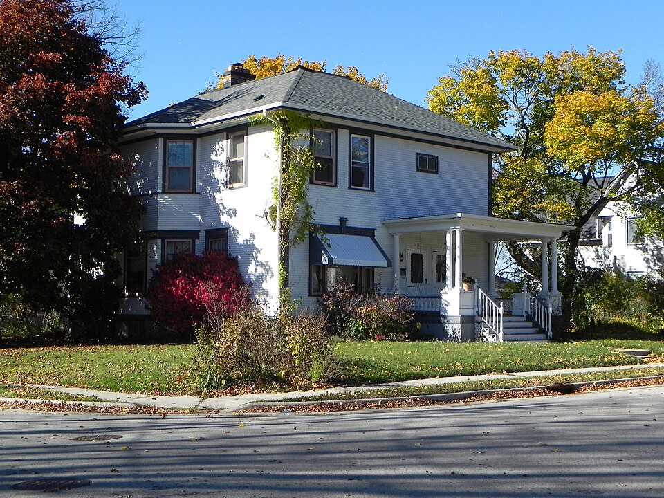
Built in 1904. Listed on the National Register of Historic Places in 1988.
One of 30 National Register listings published here for Washington County · listed in 1988 · category: Building · built in 1904.
Sources: the case file at the National Archives · the National Register database, National Park Service
Regional context, not property-specific evidence. The federal wildfire occurrence database lists 14 fires within 5 miles of William L. Kissel House between 2018 and 2020, burning about 47 acres in total. None started naturally. None was recorded as arson. Distance is straight-line from the map coordinates, so a fire counted here may appear on a neighbouring settlement's page as well.
| Reported cause | Fires |
|---|---|
| Debris and open burning | 8 |
| Missing data/not specified/undetermined | 6 |
The most recent of them, most recent first, with the day each was reported and the service that recorded it.
| Date | Cause | Size | Reported by | Name on the report |
|---|---|---|---|---|
| 2 June 2018 | Debris and open burning | 1.0 acres | Wisconsin Department of Natural Resources | 366 |
| 8 May 2018 | Missing data/not specified/undetermined | 1.0 acres | Wisconsin Department of Natural Resources | 257 |
| 1 May 2018 | Debris and open burning | under an acre | Wisconsin Department of Natural Resources | 229 |
| 6 April 2019 | Debris and open burning | 1.0 acres | Wisconsin Department of Natural Resources | 403 |
| 4 April 2020 | Missing data/not specified/undetermined | under an acre | Wisconsin Department of Natural Resources | 2000045 |
| 30 April 2018 | Debris and open burning | 15 acres | Wisconsin Department of Natural Resources | 223 |
| 29 April 2018 | Debris and open burning | under an acre | Wisconsin Department of Natural Resources | 216 |
| 28 April 2018 | Debris and open burning | 2.0 acres | Wisconsin Department of Natural Resources | 213 |
Regional context, not property-specific evidence. The federal mineral resources record lists 2 workings within 5 miles of William L. Kissel House: 1 past producer, 1 producer. 1 still produces. What was taken out: Sand and Gravel, Construction, Stone, Crushed/Broken. Distance is straight-line from the map coordinates, so a quarry counted here may appear on a neighbouring settlement's page as well.
| Where | Site | Commodity | Status | Recorded |
|---|---|---|---|---|
| Slinger Pit | Sand and Gravel, Construction | Past Producer | ||
| Stiemke Quarry | Stone, Crushed/Broken | Producer |
Regional context, not property-specific evidence. The National Weather Service names Hartford, the town this property stands in, in 64 storm reports between 1996 and 2025: 30 thunderstorm wind, 26 hail, 3 flash flood, 2 funnel cloud. The reports record 1 injury. Each account below is quoted exactly as the forecast office filed it, from the NOAA Storm Events Database, and each date opens the federal record of that event.
| When | Event | Place named | Harm | What the report says |
|---|---|---|---|---|
| June 2006 | Tornado (F1) | Hartford | 1 hurt, $4,000,000 | This tornado segment is a continuation of the Dodge County segment southeast of Rubicon. This second segment entered Washington County at a location 2.0 miles west of Hartford (about 0.6 mile south of where STH 60 goes east into Dodge Co.) and headed east-southeast through the southern part of the city of Hartford. The tornado strengthened to a high end F1 as it passed through the city. Around 147 residences sustained at least some damage ranging from tree damage to severe structural damage. Ten businesses also sustained structural damage. Lincoln Elementary School's roof was completely destroyed. Estimated damage amounts totaled about 4 million dollars. One person was directly injured by the tornado and two others were indirectly injured. Nobody was killed. The tornado continued east-southeast to a dissipation location 2.7 miles southeast of Hartford (about 0.1 mile southeast of the northern intersection of CTH E and K) at 1339CST. This segment of the tornado track was rated as F1 with winds of 64-97 knots (73-112 mph). |
| June 2001 | Tornado (F1) | Hartford | $400,000 | This tornado entered Washington County 2.2 miles west/northwest of Hartford, after spinning up just north/northwest of Rubicon in Dodge County. It traveled southeast and intensified to a F1 rating (winds about 78 to 87 knots, or 90 to 100 mph) as it cut across the southwest part of Hartford. This tornado inflicted minor damage on 250 homes, major damage to 5 homes, and minor damage to 3 businesses. Additional tornado-related costs, such as debris removal, protective measures, etc, amounted to $102,100. |
| May 2004 | Thunderstorm Wind | Hartford | $350,000 | no account filed |
| June 2011 | Hail | Hartford | $100,000 | This hail swath was about 3 miles wide, resulting in numerous dented vehicles. Damage amount is rough estimate. |
| August 2007 | Flash Flood | Hartford | $100,000 | Heavy rain from thunderstorms resulted in flash flood conditions northeast of Hartford. Rainfalls of 2 to 3 inches were measured in the area. A flower farm reported substantial damage amounts due to the heavy rains, with some small hail adding insult. Soil erosion and crop damage also occurred on several other farms in that area. in the Watertown to Rubicon area. Fast-flowing water depths of 6 inches to 1 foot were also reported on a couple roads. Additionally, a few basements had water damage to contents. |
| September 2013 | Thunderstorm Wind | Hartford | $50,000 | Widespread tree and power line damage, including uprooted and snapped trees, starting at Druid Lake and extending to the south side of Hartford. A large tree fell on a house causing minor damage. Several corn fields suffered damage, with bent over stalks, some small areas flattened. The corn was in relatively poor condition due to a poor growing season. Then sporadic reports of trees and power lines down from Hartford to Slinger. |
| July 2001 | Thunderstorm Wind | Hartford | $30,000 | no account filed |
| July 1999 | Flash Flood | Hartford | $30,000 | no account filed |
| June 2017 | Thunderstorm Wind | Hartford | $25,000 | Numerous trees and power lines down across the county. |
| August 2007 | Thunderstorm Wind | Hartford | $25,000 | Powerful thunderstorm wind gusts up to 52 knots (60 mph) toppled several large trees and damaged some power-lines. |
| August 2007 | Thunderstorm Wind | Hartford | $25,000 | Powerful thunderstorm wind gusts up to 56 knots (65 mph) toppled several large trees and damaged some power-lines. |
| August 2007 | Thunderstorm Wind | Hartford | $25,000 | Powerful thunderstorm wind gusts up to 58 knots (68 mph) toppled several large trees and damaged some power-lines. |
| July 2005 | Thunderstorm Wind | Hartford | $25,000 | A 20 by 20 foot section of a barn door was blown off as well as a roof of a storage garage. A 100 by 30 foot corn patch was flattened. |
| June 2000 | Flash Flood | Hartford | $25,000 | no account filed |
| September 2010 | Thunderstorm Wind | Hartford | $20,000 | Fire officials reported trees blown down and damage to the roofs of two commercial buildings near Hartford by thunderstorm wind gusts estimated at 65 knots (75 mph). Damage amount is estimated. |
| July 1996 | Thunderstorm Wind | Hartford | $18,000 | no account filed |
| July 2015 | Thunderstorm Wind | Hartford | $15,000 | Sporadic tree damage across the county. A few power lines down. |
| November 2022 | Thunderstorm Wind | Hartford | $10,000 | Scattered trees and branches down, including power lines, throughout the county. |
| May 2011 | Thunderstorm Wind | Hartford | $10,000 | Severe thunderstorms affected locations along a Hartford to Allenton line with damaging winds. The severe wind gusts downed trees that damaged a car and a house. |
| July 2010 | Thunderstorm Wind | Hartford | $10,000 | The emergency manager of Washington County reported trees and power lines blown down by thunderstorm wind gusts in Hartford and a few other locations in the county. |
| August 2003 | Thunderstorm Wind | Hartford | $10,000 | no account filed |
| July 2002 | Thunderstorm Wind | Hartford | $10,000 | no account filed |
| July 2023 | Thunderstorm Wind | Hartford | $8,000 | Many 4-6 inch diameter branches down on Grand Ave. A power pole was damaged. |
| June 2019 | Thunderstorm Wind | Hartford | $8,000 | Several trees and power lines down in Hartford. A fallen tree collapsed a portion of roof. |
| August 2015 | Thunderstorm Wind | Hartford | $5,000 | Numerous 8 inch to 2 foot diameter branches down. A branch landed on a garage. |
| June 2014 | Thunderstorm Wind | Hartford | $5,000 | Multiple trees down in Hartford. |
| August 2020 | Thunderstorm Wind | Hartford | $3,000 | Several large tree branches down. |
| September 2011 | Thunderstorm Wind | Hartford | $3,000 | A trained spotter reported numerous trees and power lines downed in a 6-mile wide swath from south of Hartford to southeast of Jackson from damaging severe thunderstorm wind gusts estimated at 60 knots (69 mph). The roof was blown off a silo, trees were downed and a hay wagon moved 20 feet by the severe wind gusts on a farm at the intersection of Western Avenue and CTH P south of Jackson. |
| June 2020 | Thunderstorm Wind | Hartford | $2,000 | Several large trees down in the Town of Hartford. |
| August 2017 | Hail | Hartford | $1,000 | Dents on the hood of a car. |
| June 1999 | Thunderstorm Wind | Hartford | $1,000 | no account filed |
| October 2022 | Thunderstorm Wind | Hartford | - | A 60 mph wind gust was reported in Hartford. |
| May 2019 | Thunderstorm Wind | Hartford | - | A line of thunderstorms produced damaging wind gusts across southwest Washington County. There was a report of a snapped tree trunk around 4 inches in diameter near Hartford and a report of damage to house siding and a tree near Hubertus. |
| June 2013 | Hail | Hartford | - | The public reported 1 inch hail fell in Hartford with severe thunderstorms that moved through during the afternoon hours. |
| June 2013 | Hail | Hartford | - | The public reported 1 inch hail fell in Hartford with severe thunderstorms that moved through during the afternoon hours. |
| June 2013 | Hail | Hartford | - | The public reported 3/4 inch hail fell in Hartford with strong thunderstorms that moved through during the afternoon hours. |
| September 2011 | Hail | Hartford | - | Scattered thunderstorms that accompanied a cold front across southern Wisconsin produced hail showers over portions of Southeast Wisconsin. WHile most of teh hail was 1/4 to 1/2 inch in diameter, a trained spotter in Hartford, in western Washington County, reported 3/4 inch hail stones. |
| June 2011 | Hail | Hartford | - | Some vehicles received minor denting. |
| May 2007 | Hail | Hartford | - | The ground was covered white, but there was no damage. |
| October 2006 | Thunderstorm Wind | Hartford | - | Powerful thunderstorm winds knocked down large trees. |
| May 2025 | Hail | Hartford | - | no account filed |
| May 2025 | Hail | Hartford | - | no account filed |
| June 2024 | Hail | Hartford | - | no account filed |
| April 2023 | Hail | Hartford | - | no account filed |
| October 2020 | Hail | Hartford | - | no account filed |
| June 2017 | Hail | Hartford | - | no account filed |
| April 2016 | Hail | Hartford | - | no account filed |
| August 2015 | Hail | Hartford | - | no account filed |
| August 2015 | Hail | Hartford | - | no account filed |
| August 2015 | Hail | Hartford | - | no account filed |
| May 2014 | Hail | Hartford | - | no account filed |
| May 2014 | Hail | Hartford | - | no account filed |
| August 2013 | Hail | Hartford | - | no account filed |
| April 2007 | Heavy Rain | Hartford | - | no account filed |
| July 2006 | Hail | Hartford | - | no account filed |
| June 2005 | Thunderstorm Wind | Hartford | - | no account filed |
| August 2003 | Hail | Hartford | - | no account filed |
| May 2001 | Thunderstorm Wind | Hartford | - | no account filed |
| August 2001 | Thunderstorm Wind | Hartford | - | no account filed |
| May 2000 | Hail | Hartford | - | no account filed |
No historic map-sheet match is published for this property yet. That does not mean no map exists. This record needs a coordinate-quality review before it can be joined to a sheet boundary. Browse the county's mapped places while that work is pending.
Other National Register properties close enough to walk or drive between, ordered by distance from this one. Both positions come from the same geocoding pass that matched these properties to their map sheets.
| Photograph | Property | Distance | Listed |
|---|---|---|---|
 | Otto P. Kissel House | under 500 feet | 1988 |
 | George A. Kissel House | 0.1 miles | 1988 |
 | Louis Kissel House | 0.2 miles | 1988 |
| Kissel's Addition Historic District | 0.2 miles | 1988 | |
| Schwartz Family Home | 0.2 miles | 2018 | |
| Kissel's Wheelock Addition Historic District | 0.3 miles | 1988 |
| National Archives record | The nomination case file for reference 88002073 in Record Group 79. |
| Washington County | All 30 listed properties in this county. |