 Block
From the record
One of 57 National Register listings published here for Racine County · listed in 1991 · category: District.
Sources: the case file at the National Archives · the National Register database, National Park Service
Listed on the National Register of Historic Places in 1991.
One of 57 National Register listings published here for Racine County · listed in 1991 · category: District.
Sources: the case file at the National Archives · the National Register database, National Park Service
The chapter on Dover Town in The History of Racine and Kenosha Counties, Wisconsin .., published 1879 names Dover. This is what it says, exactly as the scans read.
JOHN RAIiliACK, farmer. Sec. 11 ; P. 0. Union Grove ; was bora in Banfishire, Scotland, June 8, 1830 ; was brought to Montreal, Canada, by his mother, in 1835, and met by his father, who had come out one year previously ; lived in Montreal, and then in Dover. He was educated in Dover ; is now a farmer, and owns 250 acres of land in Dover, including seventy-three acres of the celebrated Howe farm. He married, in Necedah, Juneau Co., Wis., Nov. 20, 1855. Mary Sarles, a native of York State; has three children - S. Emily, Charles A. and William G. He also owns 320 acres of land in Traill To., D. T., an4 is there at the present time, supervising and working it; attends United Presbyterian Church.
Passage source: The History of Racine and Kenosha Counties, Wisconsin .., published 1879.
WIXIiIA]II BAIiliACK, father of John and James ; born in Banffshire, Scotland, in 1795 ; went to Montreal, Canada, in 1834, and lived there eighteen months, where he left, to go to Black Rock, near Buffalo, N. Y., and then to Freeport, III.; in 1840, he came to Dover. He married, in Banffshire, in 1821, Margaret Bremner, of the same place. They have three children - James and John, whose biographies are above, and Janette, who married Thomas Graham, a resident of Dover.
Passage source: The History of Racine and Kenosha Counties, Wisconsin .., published 1879.
Machine-read from a century-old scan, so expect the errors a machine makes: misspelled names, dropped words, stray characters.
Read the whole chapter on Dover Town - 7,136 words on its settlement, mills, schools and churches.
Regional context, not property-specific evidence. The federal wildfire occurrence database lists 12 fires within 5 miles of Southern Wisconsin Home Historic District between 2018 and 2020, burning about 6 acres in total. None started naturally. None was recorded as arson. Distance is straight-line from the map coordinates, so a fire counted here may appear on a neighbouring settlement's page as well.
| Reported cause | Fires |
|---|---|
| Missing data/not specified/undetermined | 6 |
| Debris and open burning | 6 |
The most recent of them, most recent first, with the day each was reported and the service that recorded it.
| Date | Cause | Size | Reported by | Name on the report |
|---|---|---|---|---|
| 14 June 2018 | Debris and open burning | under an acre | Wisconsin Department of Natural Resources | 393 |
| 10 June 2019 | Debris and open burning | under an acre | Wisconsin Department of Natural Resources | 293 |
| 5 April 2020 | Debris and open burning | under an acre | Wisconsin Department of Natural Resources | 27 |
| 26 April 2018 | Debris and open burning | 4.0 acres | Wisconsin Department of Natural Resources | 18037 |
| 14 April 2018 | Missing data/not specified/undetermined | 1.0 acres | Wisconsin Department of Natural Resources | 28 |
| 11 April 2018 | Missing data/not specified/undetermined | under an acre | Wisconsin Department of Natural Resources | 25 |
| 9 March 2018 | Missing data/not specified/undetermined | under an acre | Wisconsin Department of Natural Resources | 111 |
| 30 March 2018 | Missing data/not specified/undetermined | under an acre | Wisconsin Department of Natural Resources | 153 |
No historic map-sheet match is published for this property yet. That does not mean no map exists. This record needs a coordinate-quality review before it can be joined to a sheet boundary. Browse the county's mapped places while that work is pending.
Other National Register properties close enough to walk or drive between, ordered by distance from this one. Both positions come from the same geocoding pass that matched these properties to their map sheets.
| Photograph | Property | Distance | Listed |
|---|---|---|---|
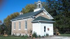 | Yorkville #4 School | 4.3 miles | 2011 |
| National Archives record | The nomination case file for reference 91001394 in Record Group 79. |
| Racine County | All 57 listed properties in this county. |