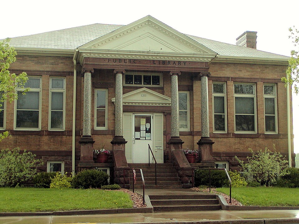
Built in 1906 (Neoclassical architecture). Listed on the National Register of Historic Places in 1992.
From the record
“Cumberland Public Library was added to the National Register of Historic Places in 1992 for its significance in architecture, education and social history. The library is still accessible today as a public library with materials and programs for all ages.”
Wikipedia article Cumberland Public Library, CC BY-SA 4.0.
One of 7 National Register listings published here for Barron County · listed in 1992 · category: Building · built in 1906, Neoclassical architecture.
Also known as. Public Library Facilities of Wisconsin MPS
City. Cumberland city
When was it built? 1906
Architectural style. Neoclassical architecture
National Register reference number.92000804- the number the National Park Service assigned this property when it was listed, and the key its nomination file is catalogued under at the National Archives.
The ground it stands on
13,933 words
The chapter on Cumberland City in History of Barron County Wisconsin, published 1922 names Cumberland. This is what it says, exactly as the scans read.
Cumberland is an incorporated city of 1528 Inhabitants, situated in the northwest corner of Cumberland Township, or, as more exactly described, in Sections 6 and 7. Township 35 north. Range 13 west. It is entirely surrounded by Beaver Dam Lake, which converts the site Into an island, sev¬ eral bridges giving access into the surround¬ ing country. From this fact it is sometimes called the "Island City." The lake is a beautiful body of water five miles long, and connects with a chain of lakes extending about sixteen miles to the northwest. The land is rolling, and in many places covered with small timber, the ancient forests hav¬ ing been cut years ago by the different log¬ ging concerns which operated in this region.
The city of Cumberland is built on an island at the lower extremity of Beaver Dam Lake, which is encircled for the most part with rugged hills, whose slopes and summits are adorned from spring to autumn with the brilliant foliage of a variety of trees and shrubs, including the pine, oak, birch and elm; the whole forming a series of magnificent pictures, the perfection of nature's handiwork, from almost number¬ less points of view. Less than five decades ago this Island and all the territory adja¬ cent to the beautiful Che-wa-cum-ma-towangok, or "Lake Made by the Beavers", as Beaver Dam Lake was called in the Chip¬ pewa language, was an unbroken wilder¬ ness, save the clearings and the cabins of two or three adventurous pioneers. In this period a city has grown up that is a sur¬ prise to the visitor. What was a tangled forest of trees, shrubs, wild creeping plants and flowers, is now a business and residence center that demands volumes of praise for the enterprise of the citizens. With wide and graded streets, substantial sidewalks, handsome homes, fine stores, electric lights and a complete system of waterworks in operation, the city is a model of what can be accomplished by the brain and hand of man.
Regional context, not property-specific
evidence. The
federal wildfire occurrence database
lists 53 fires within 5 miles of Cumberland Public Library
between 1992 and 2020, burning about 39 acres in total. 1 started naturally. 5 were recorded as arson.
Distance is straight-line from the map coordinates, so a fire counted
here may appear on a neighbouring settlement's page as well.
Reported cause
Fires
Debris and open burning
18
Missing data/not specified/undetermined
16
Equipment and vehicle use
6
Arson/incendiarism
5
Power generation/transmission/distribution
2
Smoking
1
Fireworks
1
Natural
1
Recreation and ceremony
1
Other causes
1
Misuse of fire by a minor
1
The most recent of
them, most recent first, with the day each was reported and the service
that recorded it.
Regional context, not property-specific
evidence. The federal mineral resources record lists
20 workings within 5 miles of Cumberland Public Library: 11 occurrences, 6 past producers, 3 producers.
3 still produce. What was taken out: Sand and Gravel, Construction. Distance is straight-line from the
map coordinates, so a quarry counted here may appear on a neighbouring
settlement's page as well.
Regional context, not property-specific
evidence. The National Weather Service names
Cumberland, the town this property stands in, in 55 storm reports between 1993 and 2024: 29 hail, 18 thunderstorm wind, 4 funnel cloud, 1 tornado.
The reports record 8 injuries. Each account below is quoted exactly as the forecast office
filed it, from the NOAA Storm Events Database, and each date
opens the federal record of that event.
A National Weather Service Storm Damage Survey determined that downburst winds caused substantial tree damage north of Cumberland, Wisconsin. In addition, a local business roof was blown off just north of Cumberland, and several trailers in Eagle Point Campground were damaged.
Several properties received minor damage to roofs, with two properties sustaining significant damage with 40% of their shingles damage. One home had a tree fall on it which caused considerable damage to their roof.
Strong thunderstorm winds temporarily lifted the roof off a hangar building at the Cumberland Airport. Three walls of the hangar buckled as the roof settled back down. As a result the entire structure collapsed onto three airplanes stored in the hangar.
Numerous trees were downed or snapped off, some two feet in diameter, near the intersection of County Highways P and T. A house lost half its roof, and trees were down on another house.
Several reports of dime, up to half dollar size hail were reported from north of McKinley in Polk County, extending to the southeast in Barron County, near Cumberland, Wisconsin.
Power lines snapped near Cumberland just north of Highway 48. Several homes damaged along Highway 48, just east of Cumberland. One home at 1142 Highway 48 received extensive damage to roof and portion of wall. Many trees and power lines downed in this region. Some information obtained through the Cumberland Advocate newspaper.
No historic map-sheet match is published
for this property yet. That does not mean no map exists. This record needs
a coordinate-quality review before it can be joined to a sheet boundary.
Browse the county's mapped places while that work is
pending.
Listed places nearby
1 within 8 miles
Other National Register properties close
enough to walk or drive between, ordered by distance from this one. Both
positions come from the same geocoding pass that matched these properties
to their map sheets.
Listing record. National Park Service National Register of Historic Places, listed-properties dataset, current to 2026-05-22.
Map join. Address geocoded through the United States Census geocoder, then tested against the published boundary of every sheet in the USGS Historical Topographic Map Collection.
How this page is made. Listing fields come from federal records; map-sheet coverage is a labelled coordinate-to-boundary calculation, not a source-field claim.
Wildfire. Short, Karen C. 2022. Spatial wildfire occurrence data for the United States, 1992-2020 [FPA_FOD_20221014]. 6th Edition. Fort Collins, CO: Forest Service Research Data Archive. https://doi.org/10.2737/RDS-2013-0009.6 Collected with United States Government funding and usable without additional permissions or fees.
Mines and quarries. USGS Mineral Resources Data System (MRDS) https://mrdata.usgs.gov/mrds/ A work of the United States government, no copyright under 17 U.S.C. 105.
Storms. NOAA National Centers for Environmental Information, Storm Events Database https://www.ncei.noaa.gov/stormevents/ A work of the United States government, no copyright under 17 U.S.C. 105. Narratives are quoted verbatim from the National Weather Service report and are not edited or summarised.
 Block