 Block
From the record
One of 300 National Register listings published here for Milwaukee County · listed in 1993 · category: Building · built in 1884.
Sources: the case file at the National Archives · the National Register database, National Park Service
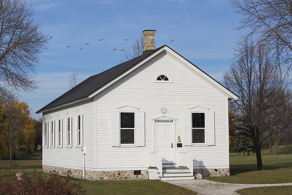
Built in 1884. Listed on the National Register of Historic Places in 1993.
One of 300 National Register listings published here for Milwaukee County · listed in 1993 · category: Building · built in 1884.
Sources: the case file at the National Archives · the National Register database, National Park Service
Regional context, not property-specific evidence. The federal wildfire occurrence database lists 20 fires within 5 miles of Brown Deer School between 2014 and 2020, burning about 24 acres in total. None started naturally. 2 were recorded as arson. Distance is straight-line from the map coordinates, so a fire counted here may appear on a neighbouring settlement's page as well.
| Reported cause | Fires |
|---|---|
| Missing data/not specified/undetermined | 13 |
| Misuse of fire by a minor | 3 |
| Arson/incendiarism | 2 |
| Smoking | 1 |
| Debris and open burning | 1 |
The most recent of them, most recent first, with the day each was reported and the service that recorded it.
| Date | Cause | Size | Reported by | Name on the report |
|---|---|---|---|---|
| 9 August 2020 | Arson/incendiarism | 1.0 acres | Wisconsin Department of Natural Resources | 1768522 |
| 7 August 2020 | Misuse of fire by a minor | 1.0 acres | Wisconsin Department of Natural Resources | 1767727 |
| 22 August 2020 | Missing data/not specified/undetermined | under an acre | Wisconsin Department of Natural Resources | 1772992 |
| 21 August 2020 | Debris and open burning | 1.0 acres | Wisconsin Department of Natural Resources | 1772607 |
| 13 August 2020 | Misuse of fire by a minor | 1.0 acres | Wisconsin Department of Natural Resources | 1769924 |
| 8 July 2018 | Missing data/not specified/undetermined | under an acre | Wisconsin Department of Natural Resources | 1804347 |
| 29 July 2020 | Misuse of fire by a minor | 1.0 acres | Wisconsin Department of Natural Resources | 1764515 |
| 13 July 2018 | Missing data/not specified/undetermined | under an acre | Wisconsin Department of Natural Resources | 1804468 |
Regional context, not property-specific evidence. The federal mineral resources record lists 1 working within 5 miles of Brown Deer School: 1 unknown. None of them still produces. What was taken out: Stone. Distance is straight-line from the map coordinates, so a quarry counted here may appear on a neighbouring settlement's page as well.
| Where | Site | Commodity | Status | Recorded |
|---|---|---|---|---|
| Own Crews | Stone | Unknown |
Regional context, not property-specific evidence. The National Weather Service names Brown Deer, the town this property stands in, in 29 storm reports between 1995 and 2022: 13 thunderstorm wind, 8 hail, 3 heavy rain, 3 flash flood. No death or injury is recorded in these reports. Each account below is quoted exactly as the forecast office filed it, from the NOAA Storm Events Database, and each date opens the federal record of that event.
| When | Event | Place named | Harm | What the report says |
|---|---|---|---|---|
| June 2008 | Flash Flood | Brown Deer | $77,970,000 | Heavy rains resulted in flash flooding across much of Milwaukee County. Water depths on some roads reached 3 to 4 feet and many cars stalled. Water entered many homes and businesses. Two other flash flood event occurred in Milwaukee County on June 7th. Collectively, these 3 flash floods resulted in home and business damage along with some crop losses. It was nearly impossible to break down the damages by flash flood event. Therefore, the collective breakdown for the 3 flash flood events is provided in the June 8th StormData entry for Milwaukee County.||The collective breakdown for residential home losses were: 3957 minimally affected, 2583 with minor damage, and 1135 with major damage (total of $32/301 million for home losses). The total business losses were $5.855 million. Crop losses were $15.5 thousand. Public sector damage was about $40.814 million. Several roads and bridges that sustained damage. On June 7th, 4.93 inches of rain fell at Milwaukee Mitchell Field, breaking the old record rainfall for the date which was 2.44 inches (June 7, 1916). On June 8th, 2.25 inches of rain broke the old record rainfall for the date which was 1.24 inches (June 8, 1974). Combined, these two days of rainfall broke the 48-hour all-time rainfall record at Milwaukee. The previous record was 6.84 inches, which was recorded on August 5-6, 1986. On June 7-8, 2008, Milwaukee observed 7.18 inches of rain. |
| April 2006 | Hail | Brown Deer | $1,990,000 | no account filed |
| April 2006 | Hail | Brown Deer | $1,990,000 | no account filed |
| April 2007 | Lightning | Brown Deer | $25,000 | Dozens of power outages resulted from lightning stikes throughout Milwaukee County. About 1400 customers were left without electrical power. |
| August 2007 | Thunderstorm Wind | Brown Deer | $25,000 | Powerful thunderstorm wind gusts up to 52 knots (60 mph) toppled several large trees and damaged some power-lines. |
| July 1996 | Thunderstorm Wind | Brown Deer | $12,000 | no account filed |
| June 2008 | Flash Flood | Brown Deer | $10,000 | Heavy rains resulted in flash flooding across the northern part of Milwaukee County. Water depths on some roads reached 3 to 4 feet and many cars stalled. Water entered many homes and businesses. Another flash flood event occurred across mostly southern Milwaukee County on June 7th, and another flash flood event occurred on June 8th. Collectively, these 3 flash floods resulted in home and business damage along with some crop losses. It was nearly impossible to break down the damages by flash flood event. Therefore, the collective breakdown for the 3 flash flood events is provided in the June 8th StormData entry for Milwaukee County. |
| July 2022 | Flash Flood | Brown Deer | $5,000 | Flash flooding of streets including a flooded Green Bay Road after a quick 2-2.5 inches of rainfall. |
| September 2010 | Lightning | Brown Deer | $3,000 | Damage to an antenna and minor electrical damage due to a lightning strike to a residence was reported by the county emergency manager. |
| July 2003 | Thunderstorm Wind | Brown Deer | $3,000 | no account filed |
| June 1996 | Thunderstorm Wind | Brown Deer | $3,000 | no account filed |
| July 2018 | Thunderstorm Wind | Brown Deer | $2,000 | Several trees down. |
| May 2017 | Thunderstorm Wind | Brown Deer | $2,000 | Several tree branches down. |
| May 1998 | Thunderstorm Wind | Brown Deer | $800 | no account filed |
| July 2022 | Thunderstorm Wind | Brown Deer | $500 | A large tree limb down. |
| July 2018 | Thunderstorm Wind | Brown Deer | $500 | A large tree branch down. |
| July 2010 | Thunderstorm Wind | Brown Deer | - | A trained spotter measured a thunderstorm wind gust at 61 mph (53 knots) 4 miles west of Brown Deer. The wind gusts snapped small trees, with trunks about 6 inches in diameter. |
| March 2007 | Hail | Brown Deer | - | The ground was covered white by the hail. |
| June 2022 | Hail | Brown Deer | - | no account filed |
| March 2007 | Hail | Brown Deer | - | no account filed |
| April 2007 | Heavy Rain | Brown Deer | - | no account filed |
| October 2006 | Hail | Brown Deer | - | no account filed |
| May 2004 | Heavy Rain | Brown Deer | - | no account filed |
| May 2004 | Heavy Rain | Brown Deer | - | no account filed |
| May 2004 | Hail | Brown Deer | - | no account filed |
| May 2004 | Hail | Brown Deer | - | no account filed |
| April 2002 | Thunderstorm Wind | Brown Deer | - | no account filed |
| July 2002 | Thunderstorm Wind | Brown Deer | - | no account filed |
| July 1995 | Thunderstorm Wind | Brown Deer | - | no account filed |
No historic map-sheet match is published for this property yet. That does not mean no map exists. This record needs a coordinate-quality review before it can be joined to a sheet boundary. Browse the county's mapped places while that work is pending.
Other National Register properties close enough to walk or drive between, ordered by distance from this one. Both positions come from the same geocoding pass that matched these properties to their map sheets.
| Photograph | Property | Distance | Listed |
|---|---|---|---|
 | Range Line Road Bridge | 1.7 miles | 2015 |
 | Elderwood | 3.9 miles | 1980 |
 | Starke Meyer House | 4.1 miles | 1985 |
 | Town of Milwaukee Town Hall | 4.4 miles | 1986 |
 | Albert and Edith Adelman House | 4.4 miles | 2005 |
 | Mary L. Nohl Art Environment | 4.6 miles | 2005 |
| National Archives record | The nomination case file for reference 93001427 in Record Group 79. |
| Milwaukee County | All 300 listed properties in this county. |