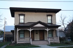
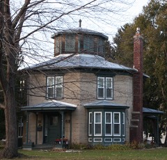
Listed on the National Register of Historic Places in 1995.
From the record
“Congregational Church. - There was held, at the Ripon Hotel, November 21, 1850, a meeting for the purpose of organizing a church. Clary, of the American Home Missionary Society, was Moderator, and Rev.”
The History of Fond Du Lac County, Wisconsin (1880). Machine-read text.
One of 51 National Register listings published here for Fond du Lac County · listed in 1995 · category: District.
National Register reference number.95000679- the number the National Park Service assigned this property when it was listed, and the key its nomination file is catalogued under at the National Archives.
What happened here
An account from the chapter on Ripon town. The inset identifies its exact
source book and publication year.
The first man to shed Wisconsin blood on a Southern battlefield in the rebellion, was Lieut. William A. Matthews, of Company G, First Wisconsin Volunteers, who was severely wounded at the battle of Falling Waters, in July, 1861, in Virginia. He enlisted at Fond du Lac, his home. The last Wisconsin blood shed was at the capture of Jeff Davis, in Irwin County, Ga., May 10, 1865, when several men were wounded by volleys fired by a detachment of the Fourth Michigan Cavalry upon a detachment of the First Wisconsin Cavalry.
In 1873, David P. Mapes, the "founder of Ripon," published a volume of nearly three hundred pages, entitled, " History of the City of Ripon and of its Founder." The peculiarity of his style may be discovered from an extract, taken from the prefoce :
The news that Fort Sumter had been fired upon and had surrendered reached Fond du Lac, Ripon and Waupun Saturday evening, April 13, 1861, but was not generally disseminated until Sunday. Everything was dropped, and people rushed to the centers of population and information for the latest news. Newspapers were in demand and commanded almost any price, one man paying a dollar for a copy of the Chicago Tribune. Impromptu meetings to sustain the Government were held everywhere, the first of which any record was left being held Sunday evening, April 14, in the city of Fond du Lac. On Thursday evening, the largest meeting ever held in that city was addressed at Amory Hall, by Edward S. Bragg, J. M. Gillet, S. E. Lefferts and Mason C. Darling. The intensity of the excitement, patriotism and enthusiasm manifested cannot be described. Resolutions upholding the Government, and couched in the strongest possible language, were adopted. About $4,000 was raised to care for the families of soldiers, and pledges were offered on every hand to furnish wood, meat, flour and provisions to soldiers' wives and children. Men offered houses free of rent ; physicians offered medical attendance free of charge, and the City Council voted, at a special meeting, although it had no right to do so, $5,000 to aid soldiers' families. Patriotism and generosity ran riot. War meetings were appointed in almost every schoolhouse in the county, and speakers were in great demand. The demand, however, was supplied, as men who had never made a speech before, and have not since, proved to be fountains of patriotic eloquence. The Reporter, of Fond du Lac, in its issue of April 27, 1861, thus briefly but graphically describes the excitement of the hour:
Regional context, not property-specific
evidence. The
federal wildfire occurrence database
lists 31 fires within 5 miles of Ripon College Historic District
between 1993 and 2020, burning about 47 acres in total. None started naturally. 1 was recorded as arson.
Distance is straight-line from the map coordinates, so a fire counted
here may appear on a neighbouring settlement's page as well.
Reported cause
Fires
Debris and open burning
19
Equipment and vehicle use
6
Smoking
2
Fireworks
1
Missing data/not specified/undetermined
1
Arson/incendiarism
1
Recreation and ceremony
1
The most recent of
them, most recent first, with the day each was reported and the service
that recorded it.
Regional context, not property-specific
evidence. The federal mineral resources record lists
4 workings within 5 miles of Ripon College Historic District: 2 past producers, 2 producers.
2 still produce. What was taken out: Sand and Gravel, Construction, Stone, Crushed/Broken. Distance is straight-line from the
map coordinates, so a quarry counted here may appear on a neighbouring
settlement's page as well.
Regional context, not property-specific
evidence. The National Weather Service names
Ripon, the town this property stands in, in 37 storm reports between 1995 and 2026: 22 thunderstorm wind, 10 hail, 3 flash flood, 1 lightning.
No death or injury is recorded in these reports. Each account below is quoted exactly as the forecast office
filed it, from the NOAA Storm Events Database, and each date
opens the federal record of that event.
Heavy rains resulted in flash flooding across much of western Fond du Lac County. Water depths on road surfaces reached 3 feet or more and there were gravel washouts. Some farm fields remained flooded into early July. The breakdown for residential home losses were: 4000 minimally affected, 2100 with minor damage, 125 with major damage, and 15 destroyed (total of $3.87 million for home losses). The breakdown for business losses were: 35 with minor damage (total of $242 thousand). Crop losses were estimated at $9 million. Public sector damage was about $772 thousand. There were several roads and bridges that sustained damage.
Multiple reports of trees down, snapped power poles, road closures, and power outages in the Ripon area. Sheet metal roofing or siding was strewn in the field on either side of Brandon Street, north of the intersection with Highway KK. Damage was assessed to be due to straight-line winds. A man was killed when he drove his car into a downed tree on a road near Ripon.
Heavy rains resulted in flash flooding across much of western Fond du Lac County. Water depths on road surfaces reached 3 feet or more and there were gravel washouts. Manhole covers popped in Ripon. Some farm fields remained flooded into early July. The breakdown for residential home losses were: 1000 minimally affected, 500 with minor damage, 25 with major damage, and 5 destroyed (total of $1 million for home losses). The breakdown for business losses were: 15 with minor damage (total of $50 thousand). Crop losses were estimated at 17 million. Public sector damage was about $1.3 million. There were several roads and bridges that sustained damage.
Street and parking low flooding led to water rushing into a business on highway 23 just east of Ripon. One hour rainfall estimated by doppler radar was 1.50 inches.
No historic map-sheet match is published
for this property yet. That does not mean no map exists. This record needs
a coordinate-quality review before it can be joined to a sheet boundary.
Browse the county's mapped places while that work is
pending.
Listed places nearby
6 within 8 miles
Other National Register properties close
enough to walk or drive between, ordered by distance from this one. Both
positions come from the same geocoding pass that matched these properties
to their map sheets.
Listing record. National Park Service National Register of Historic Places, listed-properties dataset, current to 2026-05-22.
Map join. Address geocoded through the United States Census geocoder, then tested against the published boundary of every sheet in the USGS Historical Topographic Map Collection.
How this page is made. Listing fields come from federal records; map-sheet coverage is a labelled coordinate-to-boundary calculation, not a source-field claim.
Wildfire. Short, Karen C. 2022. Spatial wildfire occurrence data for the United States, 1992-2020 [FPA_FOD_20221014]. 6th Edition. Fort Collins, CO: Forest Service Research Data Archive. https://doi.org/10.2737/RDS-2013-0009.6 Collected with United States Government funding and usable without additional permissions or fees.
Mines and quarries. USGS Mineral Resources Data System (MRDS) https://mrdata.usgs.gov/mrds/ A work of the United States government, no copyright under 17 U.S.C. 105.
Storms. NOAA National Centers for Environmental Information, Storm Events Database https://www.ncei.noaa.gov/stormevents/ A work of the United States government, no copyright under 17 U.S.C. 105. Narratives are quoted verbatim from the National Weather Service report and are not edited or summarised.
 Block