In 1838 occurred the "Jim Crow " murder, which created great excitement, not only in Potosi but throughout the county. The Long Range, referred to on page 517, was discovered by one Phipps, who failed to find the main body of mineral and sold to Moore & Watson. The wealth soon developed in the lode tempted some persons to try to obtain forcible possession of it, and to accomplish this they enlisted two or three of a gang of ruffians who then infested the settlement, ready for any evil deed that promised plunder.
The lower part of the village, comprising the section whereon Hail's brewery is now situated, called Van Buren, with Lafayette still southward on the left bank of Grant River, previous to the building up of Potosi proper, were the principal business portions of the town. The former place is known as the "Van Buren Entry," having been originally entered by Joseph Wooley and Robert Templeton prior to 1849. It was reserved from sale for a time by the Government on account of being mineral lands ; , but, as the story goes, witnesses were hired to go -over it blindfolded, then taken to the land-office and sworn that they had been all over the ground and could see no mineral. This may or may not be true, but the sections were never of any great moment as mining ground, and the Government lost nothing in the sale of these rough -and broken points.
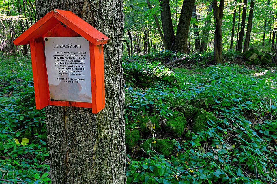
It is said that mineral was found in 1829 on the hill opposite the present Catholic church, at the foot of a tree which had been blown down, but nothing definite is known about it. In the same year Thomas Hymer built a cabin at the mouth of the hollow near the present railroad station, but did not remain there long. In the spring of 1832 William S. Anderson built a log cabin in the valley. Terrence Coyle had previously built a cabin near where British Hollow now is and lived in it with his wife and three children - one of them a son named Peter, who was afterward somewhat prominent there. In the spring of 1832 a number of miners came to the valley and located a mining camp there. The doings of this party are described by one of them, Hawkins Taylor, in a letter published in the Dubuque J Times in 1879 : "A few days before I reached Galena the surveyors in Wis¬ consin discovered lead on a bra'nch about two miles from the Mis¬ sissippi River where Potosi is located. The excitement in Galena was then very great over the new discovery and our party, that had got acquainted in the East, started for the discovery at once. Of our party were Sam Druen and Hayden Gilbert. We stopped one night at Gilmore's, near Siusinawa Mound, and the next day we got to the mines. We made little shanties of logs, generally split, and covered with elm bark, and bunks two stories high. Our bed and covering was a thick Mexican blanket, but what good sound sleep we had ! All of us were confident of striking a lead very soon. Each had a tin cup and we had a common coffee pot. Our meat was mess pork. We made our own bread. The huts were scattered for a mile along the branch, generally four men in a hut. There were about sixty miners in camp and only one quarrelsome man, an Irishman named Maloney, and his spite was against Free Williams, a peaceable man and weakly. In the midst of our happiness news came to us one evening that the Indians had defeated Stillwell on Rock River and were then making their way toward the Mississippi and would most likely pass down the Platte and rob the stores of De Tantebar at his town and Loren Wheeler at Gibraltar, and also take in our camp. Cox, then Sheriff of Grant County [it was Iowa County] had sent a messenger from Mineral Point to give us the warning. Within ten minutes of the time the news reached our camp more than forty miners were at Major Ander¬ son's camp. He had been an old Indian fighter and with one accord we went to him to be our commander and adviser. I learn that he died recently in Dubuque. There were some fifteen or twenty Irishmen in the camp who had come from Galena in skiffs and a pirogue. They had brought their provisions and tools in this way, and when the alarm was given they naturally went for the vessels, that were in a branch of the river about a mile from the camp. Maloney, the bully, got behind, and the last of the party had got out into the stream be¬ fore he got there, but he jumped in and was barely saved from drown¬ ing. Free Williams joined Stephenson's company of dragoons and made a brave soldier. By morning our party had dwindled down to thirteen. We then went to De Tantabar's on the Platte, and a man named Cornwell, a Virginian, and I went down to Wheeler's, who " had a horse and joined the dragoons." Finding that the Indians were in no hurry to come our way, we went back to our diggings. I have no record of the names, but we had with us then Major Ander¬ son, a man by the name of Hillis, Ham and his nephew, Theiskell, Ten¬ nesseeans; a man by the name of Cook, from Mississippi; Cornwelh and Nehemiah Dudley, from Vermont. Dudley was the ugliest man, I think, I ever saw, but, notwithstanding the antipathy that was then universal in the Mississippi Valley against Yankees, we all liked Dud¬ ley. I have never heard of him since I left the Mississippi, but 1 have often thought of him. We built a blockhouse of large hewn logs and kept a supply of provisions on hand in case of an attack by the In¬ dians. We mined through the day and slept in our blockhouse at night. It was on the high ground north of the branch, and 1 under¬ stood some years ago that there was a Catholic church near by, and that the old shanty I had lived in was standing near the church."
Regional context, not property-specific
evidence. The
federal wildfire occurrence database
lists 7 fires within 5 miles of Potosi Badger Huts Site
between 2018 and 2020, burning about 25 acres in total. None started naturally. None was recorded as arson.
Distance is straight-line from the map coordinates, so a fire counted
here may appear on a neighbouring settlement's page as well.
Reported cause
Fires
Debris and open burning
4
Missing data/not specified/undetermined
3
The most recent of
them, most recent first, with the day each was reported and the service
that recorded it.
Regional context, not property-specific
evidence. The federal mineral resources record lists
23 workings within 5 miles of Potosi Badger Huts Site: 11 unknowns, 9 past producers, 2 producers, 1 occurrence.
2 still produce. What was taken out: Lead, Zinc, Stone, Crushed/Broken, Stone. Distance is straight-line from the
map coordinates, so a quarry counted here may appear on a neighbouring
settlement's page as well.
Regional context, not property-specific
evidence. The National Weather Service names
Potosi, the town this property stands in, in 37 storm reports between 1994 and 2025: 18 thunderstorm wind, 8 hail, 6 flash flood, 3 tornado.
No death or injury is recorded in these reports. Each account below is quoted exactly as the forecast office
filed it, from the NOAA Storm Events Database, and each date
opens the federal record of that event.
Emergency Management reported Highway 61 closed between Potosi and Lone Elm Tree road due to shoulder washouts. Several roads were closed and basements flooded along County Roads O and B. Some homes were even evacuated in Potosi.
An estimated 65 mph wind gust occurred in Potosi. Trees were blown down and windows shattered by the winds. Some of the trees landed on houses and several campers in a campground were also damaged.
Runoff from heavy rain caused flash flooding to occur near Potosi and Dickeyville. Roads were closed in and near Potosi. Near Dickeyville, an estimated five feet of water from McAdam Branch Creek was flowing over a road.
No historic map-sheet match is published
for this property yet. That does not mean no map exists. This record needs
a coordinate-quality review before it can be joined to a sheet boundary.
Browse the county's mapped places while that work is
pending.
Listed places nearby
3 within 8 miles
Other National Register properties close
enough to walk or drive between, ordered by distance from this one. Both
positions come from the same geocoding pass that matched these properties
to their map sheets.
Listing record. National Park Service National Register of Historic Places, listed-properties dataset, current to 2026-05-22.
Map join. Address geocoded through the United States Census geocoder, then tested against the published boundary of every sheet in the USGS Historical Topographic Map Collection.
How this page is made. Listing fields come from federal records; map-sheet coverage is a labelled coordinate-to-boundary calculation, not a source-field claim.
Wildfire. Short, Karen C. 2022. Spatial wildfire occurrence data for the United States, 1992-2020 [FPA_FOD_20221014]. 6th Edition. Fort Collins, CO: Forest Service Research Data Archive. https://doi.org/10.2737/RDS-2013-0009.6 Collected with United States Government funding and usable without additional permissions or fees.
Mines and quarries. USGS Mineral Resources Data System (MRDS) https://mrdata.usgs.gov/mrds/ A work of the United States government, no copyright under 17 U.S.C. 105.
Storms. NOAA National Centers for Environmental Information, Storm Events Database https://www.ncei.noaa.gov/stormevents/ A work of the United States government, no copyright under 17 U.S.C. 105. Narratives are quoted verbatim from the National Weather Service report and are not edited or summarised.
 Block