 Block
From the record
14 National Register listings published here, 4 of them National Historic Landmarks.
Sources: the National Register database, National Park Service
67 topographic sheets cover 26 settlements here, and 14 properties are on the National Register of Historic Places.
14 National Register listings published here, 4 of them National Historic Landmarks.
Sources: the National Register database, National Park Service
Every property in this county listed on the National Register of Historic Places, with the year it was listed and the federal nomination document.
| Photograph | Property | Type | Listed | Reference |
|---|---|---|---|---|
| Chugwater Soda Fountain | building | 2022 | 100007867 | |
| Diamond Ranch | district | 1984 | 84003696 | |
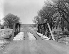 | EWZ Bridge over East Channel of Laramie River | structure | 1985 | 85000431 |
| Duncan Grant Ranch Rural Historic Landscape | district | 2013 | 13000047 | |
| Robert Grant Ranch | district | 1995 | 95001073 | |
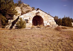 | Guernsey Lake Park | district | 1980 | 80004051 |
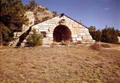 | Lake Guernsey State Park | district | 1997 | 97001260 |
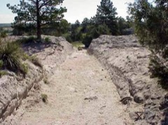 | Oregon Trail Ruts | site | 1966 | 66000761 |
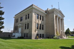 | Platte County Courthouse | building | 2008 | 08001004 |
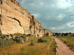 | Register Cliff | site | 1970 | 70000674 |
| Sunrise Mine Historic District | district | 2005 | 05000925 | |
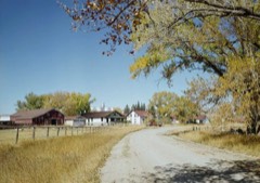 | Swan Land and Cattle Company Headquarters | building | 1966 | 66000760 |
| Wheatland Downtown Historic District | district | 2021 | 100006269 | |
| Wheatland Railroad Depot | building | 1996 | 96000077 |
Every wildfire the federal occurrence database records inside this county: 401 of them, burning about 118,315 acres. 134 started naturally and 3 were recorded as arson. Each settlement page carries the fires within five miles of it.
| Reported cause | Fires |
|---|---|
| Missing data/not specified/undetermined | 148 |
| Natural | 134 |
| Debris and open burning | 47 |
| Equipment and vehicle use | 26 |
| Railroad operations and maintenance | 13 |
| Fireworks | 11 |
| Recreation and ceremony | 7 |
| Misuse of fire by a minor | 5 |
| Arson/incendiarism | 3 |
| Power generation/transmission/distribution | 3 |
| Smoking | 2 |
| Firearms and explosives use | 2 |
The five largest, by the area the report gives. One of them was set deliberately.
| Date | Cause | Size | Reported by | Name on the report |
|---|---|---|---|---|
| 21 August 2011 | Natural | 14,484 acres | Casper Field Office | SQUAW MTN |
| 14 July 2012 | Firearms and explosives use | 14,140 acres | Casper Field Office | SAWMILL |
| 13 June 2006 | Missing data/not specified/undetermined | 13,882 acres | Casper Field Office | TRACER |
| 27 July 2006 | Natural | 13,305 acres | Casper Field Office | OLD CHICAGO |
| 10 June 2013 | Natural | 8,500 acres | Wyoming State Forestry | COW CAMP |
| 23 August 2006 | Equipment and vehicle use | 8,416 acres | Casper Field Office | TRAILER |
| 27 August 2001 | Natural | 5,410 acres | Medicine Bow-Routt National Forests, Thunder Basin National Grassland | LEROY |
| 13 August 1996 | Arson/incendiarism | 4,000 acres | Casper Field Office | SPRING CR. |
Every settlement page carries the fires within five miles of it - see the settlement index below.
The NOAA Storm Events Database holds 564 reports for this county, causing no deaths, 5 injuries and about $1,482,110 in recorded property damage. Each settlement page carries the reports that name it.
| Kind of event | Reports |
|---|---|
| Hail | 384 |
| Thunderstorm Wind | 87 |
| Tornado | 50 |
| Flash Flood | 25 |
| Flood | 6 |
| Funnel Cloud | 6 |
| Heavy Rain | 5 |
| Lightning | 1 |
The most serious of them, by death, then injury, then recorded damage. The accounts are quoted exactly as the forecast office filed them.
| When | Event | Place named | Harm | What the report says |
|---|---|---|---|---|
| June 1955 | Tornado (F3) | not stated | 3 hurt, $2,500 | no account filed |
| June 1987 | Tornado (F1) | not stated | 1 hurt, $25,000 | no account filed |
| June 2012 | Tornado (EF2) | Wheatland | 1 hurt | A large tornado touched down west of Wheatland and moved to the southeast across western Platte County. The tornado remained in contact with the ground for just over an hour before dissipating northeast of Chugwater. An NWS survey team rated the tornado an EF2 with maximum winds estimated between 130 and 135 mph. The damage assessment revealed the most significant damage to be along Olson Road, about 6 miles southwest of Wheatland. An unoccupied mobile home was completely destroyed, with unrecognizable debris spread about 50 yards from the foundation. A poorly constructed modular home with a crawl space was completely swept from its foundation, with parts of the metal frame found one quarter of a mile away. Many outbuildings on various properties were severely damaged or completely destroyed. A well-constructed one to two family home lost a large portion of the roof, but most of the walls remained intact with the exception of the garage. The most significant damage, however, was found near the intersection of Grange and Olson Roads. A very well constructed and recently completed barn was demolished, with debris found more than two miles away. In addition to the building damage, numerous large cottonwood trees were either snapped or uprooted but were not debarked. The tornado also derailed 6 empty rail cars about 6 miles northeast of Chugwater, shortly before it dissipated. The tornado crossed Interstate 25 just south of the Bordeaux exit at about 14:38 MST. No vehicles were affected by the tornado as it crossed the interstate. One person suffered minor injury from flying debris. |
| May 1993 | Thunderstorm Wind | not stated | $500,000 | Very strong and gusty winds in and near Glendo blew down some trees and moved a trailer house off its foundation. Several other trailers reported wind damage. |
| June 1991 | Tornado (F1) | not stated | $250,000 | no account filed |
| September 1986 | Tornado (F1) | not stated | $250,000 | no account filed |
| July 2009 | Hail | Chugwater | $100,000 | Hail from 1.75 to 2 inches in diameter reported. |
| September 1996 | Flash Flood | Chugwater | $100,000 | no account filed |
| July 1994 | Tornado (F1) | Wheatland | $50,000 | A severe thunderstorm developed over central Platte County of southeastern Wyoming on the evening of the 14th and struck the area near Wheatland. This storm produced a small tornado southwest of Wheatland which moved northeast at struck the southern part of the city. Two garages were leveled, one of which was torn from its foundation and thrown into a heap on the opposite side of the road. A covered porch was also torn from a house and thrown across the street. Several large trees were twisted off at their bases and tossed about. Large hail, damaging winds and heavy rain also accompanied the storm. Hail up to the size of golf balls, which was left standing four to six inches deep after the storm, demolished a car dealership causing $15,000 damage. This storm also produced damaging winds north of Wheatland which sheared off acres of 6 foot corn stalks at the ground and snapped four power poles at their bases. No one was injured in the storm. |
| July 2000 | Hail | Guernsey | $30,000 | no account filed |
| June 2009 | Hail | Chugwater | $25,000 | Golfball to softball sized hail reported in the Chugwater, Wyoming area. |
| June 1999 | Hail | Chugwater | $25,000 | no account filed |
| June 1964 | Tornado (F1) | not stated | $25,000 | no account filed |
| June 1962 | Tornado (F1) | not stated | $25,000 | no account filed |
| June 2025 | Flash Flood | Slater | $10,000 | Platte County Sheriffs Office reports flooding on Interstate 25 near mile marker 62. County roads also have water over them. |
| August 1997 | Hail | Glendo | $10,000 | Nickel size hail at Glendo marina. |
| July 1996 | Thunderstorm Wind | Wheatland | $10,000 | no account filed |
| August 1996 | Hail | Glendo | $10,000 | no account filed |
| September 1999 | Hail | Chugwater | $6,000 | 1 1/2 inch hail damaged a roof and broke a window |
| July 1997 | Flood | Guernsey | $5,000 | Time approximate; road washed out near Platte River. |
| July 1994 | Hail | Wheatland | $5,000 | A severe thunderstorm developed over central Platte County of southeastern Wyoming on the evening of the 14th and struck the area near Wheatland. This storm produced a small tornado southwest of Wheatland which moved northeast at struck the southern part of the city. Two garages were leveled, one of which was torn from its foundation and thrown into a heap on the opposite side of the road. A covered porch was also torn from a house and thrown across the street. Several large trees were twisted off at their bases and tossed about. Large hail, damaging winds and heavy rain also accompanied the storm. Hail up to the size of golf balls, which was left standing four to six inches deep after the storm, demolished a car dealership causing $15,000 damage. This storm also produced damaging winds north of Wheatland which sheared off acres of 6 foot corn stalks at the ground and snapped four power poles at their bases. No one was injured in the storm. |
| July 1994 | Thunderstorm Wind | Wheatland | $5,000 | A severe thunderstorm developed over central Platte County of southeastern Wyoming on the evening of the 14th and struck the area near Wheatland. This storm produced a small tornado southwest of Wheatland which moved northeast at struck the southern part of the city. Two garages were leveled, one of which was torn from its foundation and thrown into a heap on the opposite side of the road. A covered porch was also torn from a house and thrown across the street. Several large trees were twisted off at their bases and tossed about. Large hail, damaging winds and heavy rain also accompanied the storm. Hail up to the size of golf balls, which was left standing four to six inches deep after the storm, demolished a car dealership causing $15,000 damage. This storm also produced damaging winds north of Wheatland which sheared off acres of 6 foot corn stalks at the ground and snapped four power poles at their bases. No one was injured in the storm. |
| August 1996 | Hail | Glendo | $5,000 | no account filed |
| August 1996 | Hail | Wheatland | $5,000 | no account filed |
| September 1996 | Flash Flood | Wheatland | $2,000 | no account filed |
| July 1997 | Thunderstorm Wind | Guernsey | $1,000 | Time approximate; residential storm window blown out, large tree split. |
| May 1996 | Hail | Chugwater | $300 | no account filed |
| June 1972 | Tornado | not stated | $250 | no account filed |
| June 1977 | Tornado (F1) | not stated | $30 | no account filed |
| June 1977 | Tornado (F1) | not stated | $30 | no account filed |
| June 2025 | Hail | (76v)Glendo Thomas Airport | - | Facebook report of golf ball sized hail east of Glendo. |
| June 2025 | Thunderstorm Wind | Dwyer Junction | - | WYDOT sensor at Coleman reported a 61 mph wind gust. |
| June 2025 | Hail | Chugwater | - | Mping report of 1.25 inch hail. Changed time on report due to report being delayed until after the storm left the area. |
| June 2025 | Hail | Bordeaux | - | Trained spotter reported nickel to quarter sized hail. |
| June 2025 | Hail | Bordeaux | - | Trained spotter reports quarter sized hail. |
| June 2025 | Hail | (76v)Glendo Thomas Airport | - | Fire fighter reported quarter sized hail while fighting a lightning fire near Glendo. |
| June 2025 | Thunderstorm Wind | Glendo | - | Observer reported nickel sized hail and wind gusts of 60 mph. |
| May 2025 | Hail | Chugcreek | - | Public reported 1.0 in hail near Wheatland. |
| August 2025 | Thunderstorm Wind | Dwyer Junction | - | Mesonet station WY1 8.4 south of Sibley Peak reported a 59 mph wind gust. |
| August 2025 | Hail | Dwyer | - | Storm chaser reports hail ranging from pea to quarter sized at the intersection of US-26 and Wheatland Hwy in Platte County. |
| July 2025 | Hail | Guernsey | - | Social media post showing ping pong ball size hail. |
| July 2025 | Hail | Hartville | - | Picture from social media showing ping pong ball size hail at Guernsey State Park. |
| June 2025 | Thunderstorm Wind | Guernsey | - | Camp Guernsey Airport measured gust 64 mph. |
| June 2025 | Hail | Guernsey | - | Pictures on Social Media showed numerous 1 inch hailstones east of Guernsey. |
| June 2025 | Thunderstorm Wind | Dwyer Junction | - | WYDOT sensor at Coleman on Interstate 25 measured a wind gust of 59 MPH. |
| June 2025 | Thunderstorm Wind | Dwyer Junction | - | Coleman WYDOT site reported a thunderstorm wind gust of 60 mph. |
| July 2024 | Thunderstorm Wind | Ferguson Corner | - | WYDOT mesonet station Bordeaux (KBRX) along Interstate 25 measured wind gust. |
| July 2024 | Thunderstorm Wind | Dwyer Junction | - | WYDOT mesonet station Coleman (WY1) along Interstate 25 south of Glendo measured wind gust. |
| July 2024 | Thunderstorm Wind | Ferguson Corner | - | WYDOT mesonet station along Interstate 25 at Bordeaux (KBRX) measured wind gust 9 miles south of Wheatland. |
| July 2024 | Thunderstorm Wind | Ferguson Corner | - | WYDOT mesonet station along Interstate 25 at Bordeaux (KBRX) measured wind gust 9 miles south of Wheatland. |
| July 2024 | Thunderstorm Wind | Dwyer Junction | - | WYDOT mesonet station Coleman (WY1) along Interstate 25 measured wind gust 13 miles south of Glendo. |
| July 2024 | Thunderstorm Wind | (76v)Glendo Thomas Airport | - | WYDOT mesonet station along Interstate 25 at the Platte-Converse County line (WY56) measured wind gust. |
| July 2024 | Thunderstorm Wind | Wendover | - | Camp Guernsey AWOS station (KGUR) reported wind gust. |
| June 2024 | Flash Flood | Brinton | - | A trained weather spotter provided video of water rapidly flowing over roadways and into nearby ditches between 5 and 7 miles S of Chugwater. |
| June 2024 | Hail | Brinton | - | The Chugwater Fire Department reported 1-inch diameter hail 5 miles S of Chugwater. |
| June 2024 | Hail | Guernsey | - | Guernsey State Park officials reported quarter sized hail 2 miles NNW of Guernsey. |
| June 2024 | Hail | Hartville | - | The public reported ping pong ball sized hail in Hartville. |
| June 2024 | Thunderstorm Wind | Ferguson Corner | - | A wind gust to 58 MPH was recorded at the Bordeaux WYDOT sensor. |
| June 2024 | Hail | Slater | - | The public reported hail up to the size of golf balls with hail accumulating in fields in the Slater area. |
| June 2024 | Thunderstorm Wind | Ferguson Corner | - | A wind gust to 63 MPH was recorded at the Bordeaux WYDOT sensor. |
The Survey's mineral resources record lists 65 workings inside this county. 15 still produce and 50 are closed or unrecorded. Each settlement page carries the workings within five miles of it.
| Commodity | Workings |
|---|---|
| Vermiculite | 11 |
| Iron | 8 |
| Dolomite | 8 |
| Uranium | 7 |
| Graphite | 6 |
| Calcium | 5 |
| Silica | 4 |
| Copper | 3 |
| Gold | 3 |
| Stone, Crushed/Broken | 2 |
| Sand and Gravel, Construction | 2 |
| Mica | 1 |
| Stone | 1 |
| Limestone, General | 1 |
The least common of them first, because a county's hundredth gravel pit says nothing its first ten did not.
| Where | Site | Commodity | Status | Recorded |
|---|---|---|---|---|
| Collins & Groves Deposit | Mica | Producer | ||
| Collins Deposit | Talc-Soapstone | Occurrence | ||
| Green Mtn Boy | Copper, Silver | Past Producer | ||
| Ingleside Quarries | Limestone, General | Past Producer | ||
| Pete Kiewit & Sons | Stone | Producer | ||
| Plaga-Judd Deposit | Nickel | Occurrence | ||
| Sunrise Mine | Iron, Zinc | Past Producer | 1887, 1901, 1963 | |
| Unknown | Thorium, REE | Prospect | ||
| Vaughn-Hyslop Deposit | Gemstone | Occurrence | ||
| Basins Mill | Stone, Crushed/Broken | Producer | ||
| Guernsey Quarry | Sand and Gravel, Construction | Producer | ||
| May No. 1 Quarry | Stone, Crushed/Broken | Producer | ||
| Wheatland Pit | Sand and Gravel, Construction | Producer | ||
| Coony Hill Prospect | Gold | Occurrence | ||
| Jehosephat Prospect | Iron, Copper | Occurrence | Hematite, Malachite | |
| Jehosophat Prospect | Copper | Prospect | ||
| Unknown | Gold | Occurrence | ||
| Whippoorwill Claim | Gold | Prospect | ||
| Cassa Area | Silica | Occurrence | ||
| Friday #2 Prospect | Silica | Prospect | ||
| Unknown | Silica | Occurrence | ||
| Wilde & Deer Corne Mines | Silica | Past Producer | ||
| Emerald Group | Calcium | Occurrence | ||
| Unknown | Calcium | Prospect | ||
| Unknown | Calcium | Prospect | ||
| Unknown | Calcium | Producer | ||
| Unknown | Calcium | Prospect | ||
| George Creek | Graphite | Prospect | ||
| Rabbit Creek Area | Graphite | Producer | ||
| Texan Lode | Graphite | Prospect | ||
| Unknown | Graphite | Prospect | ||
| Unknown | Graphite | Prospect | ||
| Unknown | Graphite | Prospect | ||
| Big Mac Claim | Uranium | Occurrence | ||
| Unknown | Uranium | Occurrence | ||
| Unknown | Uranium | Occurrence | Vein | |
| Unknown | Uranium | Occurrence | ||
| Unknown | Uranium | Occurrence | ||
| Unknown | Uranium | Occurrence | ||
| Unknown | Uranium | Occurrence | ||
| Chicago Mine | Iron | Past Producer | 1975 | |
| Good Fortune Iron Mine | Iron | Past Producer | 1857, 1898 | |
| Lt Sisson Dolomite Deposit | Dolomite | Prospect | ||
| Lucky Gus Prospect | Iron | Occurrence | ||
| Rabbit Creek | Iron | Occurrence | ||
| Romsa Dolomite Deposit | Dolomite | Prospect | ||
| Unidentified Prospect | Iron | Occurrence | Hematite | |
| Unknown | Dolomite | Prospect | ||
| Unknown | Dolomite | Prospect | ||
| Unknown | Dolomite | Prospect | ||
| Unknown | Dolomite | Prospect | ||
| Unknown | Dolomite | Prospect | ||
| Unknown | Dolomite | Prospect | ||
| Unnamed | Iron | Occurrence | ||
| Dixie Queen Claim | Vermiculite | Producer | ||
| Jbc Deposit | Vermiculite | Producer | ||
| Mcdougal Deposit | Vermiculite | Producer | ||
| Palmer Canyon Deposit | Vermiculite | Producer | ||
| Roff Deposit | Vermiculite | Producer | ||
| Unknown | Vermiculite | Producer | ||
| Unknown | Vermiculite | Prospect | ||
| Unknown | Vermiculite | Producer | ||
| Unknown | Vermiculite | Occurrence | ||
| Unknown | Vermiculite | Prospect | ||
| Unknown | Vermiculite | Occurrence |
Named settlements recorded in the Geographic Names Information System, each with the topographic sheets covering it. Villages, hamlets and abandoned places alike. Each is shown with the nearest named watercourse or landform and the survey quadrangle it falls on.
Chugwater census division · 82210 · Near Mendenhal Draw · Whitcomb Hill quadrangle
8 sheets, 1954 to 1990
Glendo census division · 82213 · On North Bear Creek · Cassa quadrangle
15 sheets, 1896 to 1990
Chugwater census division · 82210 · On Dry Creek · Chugwater quadrangle
8 sheets, 1953 to 1990
Wheatland census division · 82201 · On Rock Creek · Wheatland quadrangle
13 sheets, 1896 to 1990
Chugwater census division · 82210 · On North Chugwater Creek · Whitcomb Hill quadrangle
8 sheets, 1954 to 1990
Glendo census division · 82201 · Near Coleman Butte · Coleman Butte quadrangle
11 sheets, 1950 to 1981
Wheatland census division · 82201 · Ferguson Corner quadrangle
8 sheets, 1953 to 1990
Wheatland census division · 82201 · Near Ayers Draw · Wheatland quadrangle
13 sheets, 1896 to 1990
Glendo census division · 82213 · Near Whiskey Gulch · Glendo quadrangle
10 sheets, 1950 to 1981
Guernsey census division · 82214 · Near Warm Springs Canyon · Guernsey quadrangle
15 sheets, 1896 to 1990
Guernsey census division · 82215 · Near Sparks Canyon · Guernsey quadrangle
15 sheets, 1896 to 1990
Guernsey census division · 82213 · Near Miller Draw · Meadowdale quadrangle
7 sheets, 1954 to 1982
Wheatland census division · 82201 · On Rock Creek · Wheatland quadrangle
13 sheets, 1896 to 1990
Guernsey census division · 82215 · Near Sparks Canyon · Guernsey quadrangle
15 sheets, 1896 to 1990
Guernsey census division · 82201 · On North Laramie River · Dwyer quadrangle
14 sheets, 1896 to 1990
Glendo census division · On Cottonwood Creek · Guernsey Reservoir quadrangle
15 sheets, 1896 to 1990
Wheatland census division · 82201 · On Rock Creek · Wheatland quadrangle
13 sheets, 1896 to 1990
Wheatland census division · 82201 · Near Ayers Draw · Wheatland quadrangle
13 sheets, 1896 to 1990