Listed on the National Register of Historic Places in 2003.
From the record
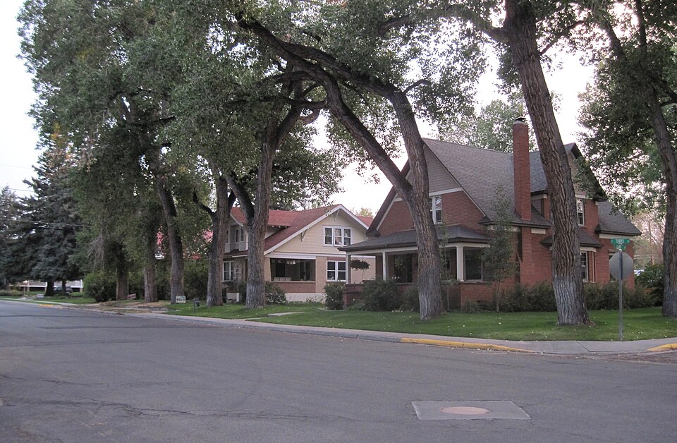
“Jackson Park Town Site Addition Brick Row is a group of three historic houses and two frame garages located on the west side of the 300 block of South Third Street in Lander, Wyoming. Two of the homes were built in 1917, and the third in 1919.”
Wikipedia article Jackson Park Town Site Addition Brick Row, CC BY-SA 4.0.
One of 31 National Register listings published here for Fremont County · listed in 2003 · category: Building.
National Register reference number.03000083- the number the National Park Service assigned this property when it was listed, and the key its nomination file is catalogued under at the National Archives.
Fires near this property
119 since 1994
Regional context, not property-specific
evidence. The
federal wildfire occurrence database
lists 119 fires within 5 miles of Jackson Park Town Site Addition Brick Row
between 1994 and 2020, burning about 436 acres in total. 4 started naturally. None was recorded as arson.
Distance is straight-line from the map coordinates, so a fire counted
here may appear on a neighbouring settlement's page as well.
Reported cause
Fires
Missing data/not specified/undetermined
60
Debris and open burning
19
Recreation and ceremony
10
Smoking
6
Fireworks
6
Equipment and vehicle use
6
Natural
4
Misuse of fire by a minor
3
Railroad operations and maintenance
3
Power generation/transmission/distribution
2
The most recent of
them, most recent first, with the day each was reported and the service
that recorded it.
Regional context, not property-specific
evidence. The federal mineral resources record lists
11 workings within 5 miles of Jackson Park Town Site Addition Brick Row: 6 occurrences, 2 unknowns, 2 producers, 1 prospect.
2 still produce. What was taken out: Uranium, Gypsum-Anhydrite, Zeolites, Sand and Gravel, Construction. Distance is straight-line from the
map coordinates, so a quarry counted here may appear on a neighbouring
settlement's page as well.
Regional context, not property-specific
evidence. The National Weather Service names
Lander, the town this property stands in, in 38 storm reports between 1997 and 2026: 14 hail, 11 thunderstorm wind, 5 flash flood, 4 wildfire.
No death or injury is recorded in these reports. Each account below is quoted exactly as the forecast office
filed it, from the NOAA Storm Events Database, and each date
opens the federal record of that event.
A thunderstorm produced 1.70 inches of rain in less than 30 minutes in Red Canyon. The learning center at Red Canyon Ranch was inundated with six inches of mud and water causing extensive damage. The mud, rock, and water also flooded a barn, shop, and several corrals at the ranch. Red Canyon Creek and other small tributaries were out of their banks. Road damage on the ranch was widespread. The county portion of Red Canyon Road was covered with a three-foot-deep mud flow which closed the road for much of the next week. At least one nearby residence sustained damage to a basement and destruction of their backyard landscaping due to a mud and water flow.
Gables on a pole barn under construction were destroyed on Iiams Road. A home under construction near U.S. Highway 287 and Lyons Valley Road was toppled.
Chinook winds caused rapid snow melt in the Lander Foothills that brought rapid snow melt. The warm temperatures caused rapid snow melt that rapidly increased river levels. In addition, the frozen Little Popo Agie river broke up rapidly and ice jams caused flooding of the flood prone areas in Lyons Valley. Several homes and farms in the low lying areas experienced flooding and several side roads were flooded with a few washed out.
Heavy rainfall led to flooding in Lyons Valley near Lander. The Little Popo Agie River overflowed its banks and flooded low lying areas along Lyons Valley Road. The water approached some homes along the river but did not enter them.
No historic map-sheet match is published
for this property yet. That does not mean no map exists. This record needs
a coordinate-quality review before it can be joined to a sheet boundary.
Browse the county's mapped places while that work is
pending.
Listed places nearby
2 within 8 miles
Other National Register properties close
enough to walk or drive between, ordered by distance from this one. Both
positions come from the same geocoding pass that matched these properties
to their map sheets.
Listing record. National Park Service National Register of Historic Places, listed-properties dataset, current to 2026-05-22.
Map join. Address geocoded through the United States Census geocoder, then tested against the published boundary of every sheet in the USGS Historical Topographic Map Collection.
How this page is made. Listing fields come from federal records; map-sheet coverage is a labelled coordinate-to-boundary calculation, not a source-field claim.
Wildfire. Short, Karen C. 2022. Spatial wildfire occurrence data for the United States, 1992-2020 [FPA_FOD_20221014]. 6th Edition. Fort Collins, CO: Forest Service Research Data Archive. https://doi.org/10.2737/RDS-2013-0009.6 Collected with United States Government funding and usable without additional permissions or fees.
Mines and quarries. USGS Mineral Resources Data System (MRDS) https://mrdata.usgs.gov/mrds/ A work of the United States government, no copyright under 17 U.S.C. 105.
Storms. NOAA National Centers for Environmental Information, Storm Events Database https://www.ncei.noaa.gov/stormevents/ A work of the United States government, no copyright under 17 U.S.C. 105. Narratives are quoted verbatim from the National Weather Service report and are not edited or summarised.
 Block