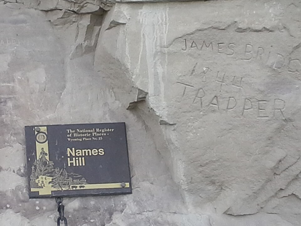
Listed on the National Register of Historic Places in 1969.
From the record
“Names Hill is a bluff located on the bank of the Green River in the U.S. state of Wyoming, where travelers on the Oregon and California trails carved their names into the rock. It is one of three notable "recording areas" along the emigrant trails in Wyoming along with Register Cliff and Independence Rock.”
Wikipedia article Names Hill, CC BY-SA 4.0.
One of 9 National Register listings published here for Lincoln County · listed in 1969 · category: Site.
National Register reference number.69000193- the number the National Park Service assigned this property when it was listed, and the key its nomination file is catalogued under at the National Archives.
Fires near this property
1 since 2007
Regional context, not property-specific
evidence. The
federal wildfire occurrence database
lists 1 fire within 5 miles of Names Hill
in 2007, burning about 4 acres in total. 1 started naturally. None was recorded as arson.
Distance is straight-line from the map coordinates, so a fire counted
here may appear on a neighbouring settlement's page as well.
Reported cause
Fires
Natural
1
The most recent of
them, most recent first, with the day each was reported and the service
that recorded it.
Regional context, not property-specific
evidence. The federal mineral resources record lists
1 working within 5 miles of Names Hill: 1 producer.
All of them still produce. What was taken out: Sand and Gravel, Construction. Distance is straight-line from the
map coordinates, so a quarry counted here may appear on a neighbouring
settlement's page as well.
Regional context, not property-specific
evidence. The National Weather Service names
La Barge, the town this property stands in, in 6 storm reports between 1997 and 2017: 2 flood, 2 flash flood, 1 funnel cloud, 1 tornado.
No death or injury is recorded in these reports. Each account below is quoted exactly as the forecast office
filed it, from the NOAA Storm Events Database, and each date
opens the federal record of that event.
Heavy rain from thunderstorms brought flooding and mudslides in, and to the south of, LaBarge. The flooding damaged 20 homes located mainly in the southwest portion of the town. Much of the flooding was confined to basements of homes and at least one church. High water scoured the channel of Birch Creek at the north end of town and exposed water and sewer pipes.||To the south of town, approximately four separate large channels along with many smaller rivulets flooded US Highway 189 between mileposts 77 and 81. The Wyoming Highway Patrol reported a mudslide near milepost 78 around Muddy Creek at 1651MST. Farther north near Names Hill another small canyon deposited mud and rock across the highway and onto private land. Five homes were damaged in the county, one of which was declared a total loss. Multiple sections of fence line were either washed away or completely buried by debris. Mud and rock plugged culverts along the highway and also buried culvert inlets. This set the stage for additional flooding across US Highway 189 over the course of the next several days.
High water on the Green River near LaBarge above Fontenelle Reservoir caused the inundation of County Road 318 and lowland areas in the broad river plain.
High water was reported to have completely washed out several BLM and USFS roads near the Green River in northern Lincoln County north of the Fontenelle Reservoir.
Culverts that were plugged and buried by mud and rock from a flash flood on September 12, were unable to handle another deluge of water on the afternoon of Saturday, September 14. The heavy rain caused mudslides that covered portions of US Highway 189 south of LaBarge between mileposts 80 and 82. The road was closed at 1700MST Saturday to enable the Wyoming Department of Transportation to clean-up the debris. The road was opened the morning of September 15.
No historic map-sheet match is published
for this property yet. That does not mean no map exists. This record needs
a coordinate-quality review before it can be joined to a sheet boundary.
Browse the county's mapped places while that work is
pending.
Listing record. National Park Service National Register of Historic Places, listed-properties dataset, current to 2026-05-22.
Map join. Address geocoded through the United States Census geocoder, then tested against the published boundary of every sheet in the USGS Historical Topographic Map Collection.
How this page is made. Listing fields come from federal records; map-sheet coverage is a labelled coordinate-to-boundary calculation, not a source-field claim.
Wildfire. Short, Karen C. 2022. Spatial wildfire occurrence data for the United States, 1992-2020 [FPA_FOD_20221014]. 6th Edition. Fort Collins, CO: Forest Service Research Data Archive. https://doi.org/10.2737/RDS-2013-0009.6 Collected with United States Government funding and usable without additional permissions or fees.
Mines and quarries. USGS Mineral Resources Data System (MRDS) https://mrdata.usgs.gov/mrds/ A work of the United States government, no copyright under 17 U.S.C. 105.
Storms. NOAA National Centers for Environmental Information, Storm Events Database https://www.ncei.noaa.gov/stormevents/ A work of the United States government, no copyright under 17 U.S.C. 105. Narratives are quoted verbatim from the National Weather Service report and are not edited or summarised.
 Block