 Block
From the record
9 National Register listings published here.
Sources: the National Register database, National Park Service
91 topographic sheets cover 30 settlements here, and 9 properties are on the National Register of Historic Places.
9 National Register listings published here.
Sources: the National Register database, National Park Service
Every property in this county listed on the National Register of Historic Places, with the year it was listed and the federal nomination document.
| Photograph | Property | Type | Listed | Reference |
|---|---|---|---|---|
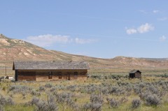 | Fossil Oregon Short Line Depot | building | 2013 | 13000919 |
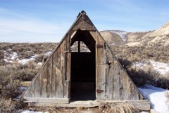 | Haddenham Cabin | building | 2003 | 03001339 |
 | Lincoln County Courthouse | building | 1984 | 84000385 |
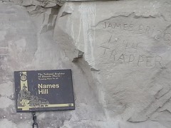 | Names Hill | site | 1969 | 69000193 |
 | J. C. Penney Historic District | district | 1978 | 78002830 |
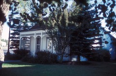 | J. C. Penney House | building | 1976 | 76001958 |
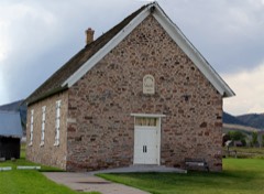 | Rock Church | building | 1985 | 85003222 |
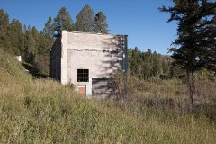 | Salt River Hydroelectric Powerplant | district | 1993 | 93000889 |
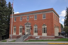 | US Post Office-Kemmerer Main | building | 1987 | 87000786 |
Every wildfire the federal occurrence database records inside this county: 762 of them, burning about 122,073 acres. 451 started naturally and 4 were recorded as arson. Each settlement page carries the fires within five miles of it.
| Reported cause | Fires |
|---|---|
| Natural | 451 |
| Recreation and ceremony | 128 |
| Missing data/not specified/undetermined | 83 |
| Debris and open burning | 36 |
| Power generation/transmission/distribution | 14 |
| Smoking | 13 |
| Equipment and vehicle use | 12 |
| Railroad operations and maintenance | 9 |
| Fireworks | 7 |
| Misuse of fire by a minor | 5 |
| Arson/incendiarism | 4 |
The five largest, by the area the report gives. None of them was recorded as arson.
| Date | Cause | Size | Reported by | Name on the report |
|---|---|---|---|---|
| 24 June 2012 | Missing data/not specified/undetermined | 65,220 acres | Bridger-Teton National Forest | FONTENELLE |
| 12 August 2000 | Natural | 14,750 acres | Bridger-Teton National Forest | FONTENELLE |
| 12 August 2000 | Natural | 9,800 acres | Bridger-Teton National Forest | BLIND TRAIL |
| 16 September 2018 | Equipment and vehicle use | 6,491 acres | Bridger-Teton National Forest | MARTEN CREEK |
| 4 August 2017 | Debris and open burning | 3,600 acres | Bridger-Teton National Forest | POLE CREEK |
| 12 July 2003 | Recreation and ceremony | 3,599 acres | Bridger-Teton National Forest | EAST TABLE |
| 29 August 2002 | Natural | 3,561 acres | Rock Springs Field Office | COMMISARY |
| 1 September 1996 | Natural | 2,780 acres | Bridger-Teton National Forest | ASPEN HOLLOW |
Every settlement page carries the fires within five miles of it - see the settlement index below.
The NOAA Storm Events Database holds 105 reports for this county, causing no deaths, 31 injuries and about $2,485,000 in recorded property damage. Each settlement page carries the reports that name it.
| Kind of event | Reports |
|---|---|
| Thunderstorm Wind | 35 |
| Hail | 34 |
| Flood | 10 |
| Flash Flood | 9 |
| Tornado | 6 |
| Wildfire | 6 |
| Funnel Cloud | 4 |
| Lightning | 1 |
The most serious of them, by death, then injury, then recorded damage. The accounts are quoted exactly as the forecast office filed them.
| When | Event | Place named | Harm | What the report says |
|---|---|---|---|---|
| August 1993 | Thunderstorm Wind | Afton | 28 hurt | A massive wind and rainstorm struck the fairgrounds blowing over two tents and shredding another. Up to 28 people received minor injuries. |
| September 1997 | Lightning | Alpine | 3 hurt | no account filed |
| September 2013 | Flash Flood | La Barge | $1,500,000 | Heavy rain from thunderstorms brought flooding and mudslides in, and to the south of, LaBarge. The flooding damaged 20 homes located mainly in the southwest portion of the town. Much of the flooding was confined to basements of homes and at least one church. High water scoured the channel of Birch Creek at the north end of town and exposed water and sewer pipes.||To the south of town, approximately four separate large channels along with many smaller rivulets flooded US Highway 189 between mileposts 77 and 81. The Wyoming Highway Patrol reported a mudslide near milepost 78 around Muddy Creek at 1651MST. Farther north near Names Hill another small canyon deposited mud and rock across the highway and onto private land. Five homes were damaged in the county, one of which was declared a total loss. Multiple sections of fence line were either washed away or completely buried by debris. Mud and rock plugged culverts along the highway and also buried culvert inlets. This set the stage for additional flooding across US Highway 189 over the course of the next several days. |
| June 2010 | Thunderstorm Wind | Turnerville | $350,000 | Several hundred trees were downed on hillsides bordering a forest service road in Willow Creek Canyon east of Turnerville. The trees completely blocked passage of vehicles and individuals to the area. |
| June 2011 | Flood | Star Valley Ranch | $167,000 | Active snowmelt in the Salt River Range caused a flood along a normally dry ditch in Star Valley Ranch. The narrow drainage near Prater Canyon brought enough water to wash out part of a road and three culverts. The high water also exposed and damaged a water line in the community. |
| August 2024 | Flash Flood | Opal | $100,000 | The Lincoln County emergency management reported flooding in the town of Opal, WY caused by heavy rain from a slow-moving thunderstorm. Rainfall amount is unknown due to not having any know weather stations in the area. Five homes experienced flash flooding, with about 6 inches of water in basements. |
| August 2024 | Flash Flood | Opal | $100,000 | The day after flash flooding occurred, more heavy rain impacted Opal, WY, leading to additional flash flooding. Large amounts of small hail and ponding water flooded roads and caused sewer backups. |
| July 2011 | Flood | La Barge | $75,000 | High water on the Green River near LaBarge above Fontenelle Reservoir caused the inundation of County Road 318 and lowland areas in the broad river plain. |
| August 2011 | Hail | Grover | $50,000 | One inch diameter hail dented vehicles, broke a few windows, and punched holes in the siding of some homes around Grover. |
| May 2011 | Flood | Fairview | $50,000 | Rising temperatures quickly melted low elevation snow in the mountains of extreme eastern Idaho. This caused flooding of Spring, Tin Cup, Crow, Jack Knife, and Stump creeks along the western edge of Star Valley. A few homeowners were forced to sandbag around their homes, build temporary levees, or dig trenches to provide relief from the rising flood waters. These tributaries fed the broad and relatively flat valley of the Salt River. Lowlands near the Salt River were inundated with water, especially north of Thayne to around the Double L Ranch near Etna. |
| July 2021 | Flash Flood | Kemmerer | $25,000 | Emergency management and trained spotters reported numerous flooded roads and basements around Kemmerer and Diamondville. |
| July 1980 | Tornado | not stated | $25,000 | no account filed |
| August 2014 | Flash Flood | Alpine | $10,000 | Heavy rain caused several mudslides across US Highway 89 around milepost 120 in the steep terrain of Snake River Canyon east of Alpine. Rainfall totals were estimated at one-half to three-quarters of an inch in less than 40 minutes. The highway was closed for about three hours and several vehicles were damaged. The slides, mostly composed of mud, were three to four feet deep in some places. |
| August 2011 | Hail | Afton Muni Arpt | $10,000 | A trained spotter northwest of Afton reported hail to the size of quarters. Hail of the same size damaged at least four county-owned vehicles parked in Afton. |
| June 2011 | Thunderstorm Wind | Afton | $5,000 | Several large trees were blown onto houses causing minor roof damage. |
| July 2007 | Thunderstorm Wind | Etna | $5,000 | no account filed |
| September 2007 | Flash Flood | Alpine | $5,000 | no account filed |
| October 2011 | Thunderstorm Wind | Freedom | $4,000 | A trained spotter reported a large tree snapped by a thunderstorm wind gust. The tree fell on a shed, causing significant damage to the roof and moving it slightly off its foundation. |
| June 2010 | Thunderstorm Wind | Thayne | $1,500 | A one foot diameter aspen tree was felled at Star Valley Ranch by thunderstorm wind gusts. |
| July 2025 | Thunderstorm Wind | Afton | $1,000 | A microburst in Afton downed trees in two locations, leading to a power outage. |
| June 2025 | Thunderstorm Wind | Afton | $1,000 | The Lincoln County Emergency Manager relayed a report of a gazebo that was destroyed by strong thunderstorm outflow winds near Afton. |
| March 2007 | Thunderstorm Wind | Cokeville | $500 | Large tree toppled in Cokeville. |
| April 2026 | Thunderstorm Wind | Etna | - | A 59 mph wind gust was reported to the north of Etna. |
| June 2025 | Hail | Alpine | - | The Public reported up to quarter size hail in the Star Valley. |
| July 2025 | Thunderstorm Wind | Sage | - | Wind gusts of 59 mph occurred to the east of Sage Junction. |
| May 2023 | Flood | Cokeville Muni Arpt | - | Minor flooding occurred in southern Lincoln County, with the most affected area along the Bear River near Pixley Dam. The floods were largely confined to low-lying agricultural land and a few dirt roads near the river. This second flood wave from melt in the mid elevations had a peak flow at the Bear River below Pixley Dam gauge reading of 1750 CFS, with the peak occurring June 1. |
| May 2023 | Flood | Cokeville Muni Arpt | - | Minor flooding occurred in southern Lincoln County, with the most affected area along the Bear River near Pixley Dam. The floods were largely confined to low-lying agricultural land and a few dirt roads near the river. This first flood wave from melt in the lower and mid elevations was the highest peak of the season, with peak flow at the Bear River below Pixley Dam gauge reading of 1760 CFS. |
| May 2023 | Flood | Auburn | - | Minor impacts from flooding confined to low lying areas near the river. No damage was reported to transportation infrastructure or property. Maximum flow of around 3500 CFS occurred from May 25 through May 26 at the Salt River near Etna river gauge. |
| August 2021 | Thunderstorm Wind | Kemmerer Muni Arpt | - | A 59 mph wind gust was reported at Kemmerer Municipal Airport. |
| June 2020 | Thunderstorm Wind | Kemmerer Muni Arpt | - | A 59 mph wind gust was reported at the Kemmerer airport. |
| May 2020 | Thunderstorm Wind | Fairview | - | Outflow winds from a thunderstorm brought damage to portions of the Star Valley. A wind gust of 60 mph was reported at the Afton, Wyoming airport. There were numerous reports of trees down as well as power lines, resulting in power outages. The worst damage was noted in Fairview, Wyoming as well as between Grover and Auburn, Wyoming. |
| October 2019 | Thunderstorm Wind | Kemmerer Muni Arpt | - | A 59 mph wind gust was reported at the Kemmerer airport. |
| September 2019 | Thunderstorm Wind | Fossil Butte Nm | - | A Park Service employee reported a 65 mph wind gust at the Fossil Butte National Monument. |
| May 2018 | Thunderstorm Wind | Star Valley Ranch | - | A trained spotter reported several downed trees at Star Valley Ranch. |
| March 2017 | Flood | Fairview | - | Rain and warm temperatures brought rapid snow melt that brought minor flooding to some homes around Crow Creek near Fairview. Sandbagging was effective in diverting water around homes and there was no damage. |
| March 2017 | Flood | Cokeville | - | A combination of rainfall and warm temperatures caused rapid snow melt that brought flooding to some areas around Cokeville. The flooding was restricted to low lying agricultural land and caused no damage. |
| June 2017 | Flood | La Barge | - | High water was reported to have completely washed out several BLM and USFS roads near the Green River in northern Lincoln County north of the Fontenelle Reservoir. |
| June 2016 | Hail | Kemmerer | - | A severe thunderstorm dropped hail the size of quarters and ping pong balls in Kemmerer and at the Port of Entry on the outskirts of town. |
| August 2016 | Hail | Kemmerer | - | Nickel sized hail fell in Kemmerer. |
| October 2016 | Thunderstorm Wind | Star Valley Ranch | - | Several live, large pine trees were blown over across a trail in the foothills just east of the town of Star Valley Ranch. A nearby weather station in the town registered a peak wind gust of 66 mph at 1301MST. |
| July 2016 | Hail | Thayne | - | A trained spotter reported penny sized hail southeast of Thayne. |
| July 2016 | Hail | Star Valley Ranch | - | A trained spotter reported nickel to quarter sized hail at Star Valley Ranch. |
| June 2015 | Hail | Afton | - | The Lincoln County Sheriff's Office reported quarter sized hail covering roads in Afton. A trained spotter also reported one inch diameter hail just to the northwest of town. |
| June 2015 | Hail | Star Valley Ranch | - | Trained spotters reported hail ranging in size from quarters to golf balls at Star Valley Ranch. |
| August 2014 | Hail | Diamondville | - | Nickel sized hail was observed on the west side of Kemmerer near US Highway 30. |
| September 2014 | Hail | Smoot | - | Hailstones up to ping pong ball size fell just north of Smoot. |
| July 2013 | Thunderstorm Wind | Star Valley Ranch | - | Wind gusts estimated at 70 mph toppled a one foot diameter aspen tree at Star Valley Ranch. |
| September 2013 | Flash Flood | La Barge | - | Culverts that were plugged and buried by mud and rock from a flash flood on September 12, were unable to handle another deluge of water on the afternoon of Saturday, September 14. The heavy rain caused mudslides that covered portions of US Highway 189 south of LaBarge between mileposts 80 and 82. The road was closed at 1700MST Saturday to enable the Wyoming Department of Transportation to clean-up the debris. The road was opened the morning of September 15. |
| September 2013 | Hail | Afton | - | Hail to the size of nickels was reported by a spotter in Afton. |
| July 2013 | Hail | Star Valley Ranch | - | A trained spotter at Star Valley Ranch reported hail up to the size of quarters. |
| May 2011 | Flood | Fairview | - | Snowmelt and rainfall combined to raise water levels on the Salt River and its tributaries in Star Valley. A private road and Fairview South Road were partially or completely submerged by flood waters in the vicinity of Fairview. Stump Creek near Auburn and both Crow and Spring creeks near Fairview climbed out of their banks inundating cropland. Along the Salt River, the water was running highest between the communities of Freedom and Etna. |
| August 2011 | Hail | Auburn | - | Approximately 600 acres of a mature grain crop near Auburn were severely damaged by one inch diameter hail. |
| August 2011 | Hail | Bedford | - | A severe thunderstorm moved through Bedford. The local post office reported hail to the size of ping-pong balls. |
| June 2010 | Hail | Thayne | - | A strong thunderstorm formed over eastern Idaho and moved into Star Valley. Nickel sized hail fell at the home of a trained weather spotter southeast of Thayne. |
| August 2008 | Hail | Star Valley Ranch | - | Penny sized hail was observed near Star Valley Ranch. |
| July 1995 | Hail | Afton | - | Thunderstorms moved through Park County producing strong winds and hail. One-half inch diameter hail fell to the south and east of Powell, damaging crops and fields. The hail piled up to a depth of 6 to 8 inches in places. |
| July 1995 | Thunderstorm Wind | not stated | - | Thunderstorms moved through Park County producing strong winds and hail. One-half inch diameter hail fell to the south and east of Powell, damaging crops and fields. The hail piled up to a depth of 6 to 8 inches in places. |
| April 1994 | Thunderstorm Wind | Thayne | - | Strong winds of unknown intensity from a thunderstorm lasted five minutes but destroyed irrigation equipment two miles north of Thayne in far western Wyoming. |
| July 1994 | Thunderstorm Wind | Cokeville | - | Wind gusts from a thunderstorm estimated at 60 to 70 mph hit the Cokeville area of western Lincoln County on the afternoon of the 5th. Extensive damage to trees and residences occurred. |
| June 2006 | Hail | Thayne | - | no account filed |
The Survey's mineral resources record lists 143 workings inside this county. 6 still produce and 137 are closed or unrecorded. Each settlement page carries the workings within five miles of it.
| Commodity | Workings |
|---|---|
| Sand and Gravel, Construction | 57 |
| Phosphorus-Phosphates | 47 |
| Uranium | 21 |
| Copper | 7 |
| Phosphorus-Phosphates, Vanadium | 2 |
| Gold | 2 |
| Iron | 2 |
| Uranium, Water, Free | 2 |
| Salt | 2 |
| Cobalt, Nickel, Cadmium, Titanium, Selenium, Molybdenum, Zinc | 1 |
| Silver, Copper, Zinc | 1 |
| Silver, Zinc | 1 |
| Silver, Gold, Zinc | 1 |
| Vanadium | 1 |
The least common of them first, because a county's hundredth gravel pit says nothing its first ten did not.
| Where | Site | Commodity | Status | Recorded |
|---|---|---|---|---|
| Afton area (vanadiferous zone) | Phosphorus-Phosphates, Vanadium, Cobalt, Nickel, Cadmium, Titanium, Selenium, Molybdenum, Zinc | Occurrence | ||
| Auburn Area Hot Springs | Sulfur, Geothermal | Occurrence | hot springs deposit | |
| Coantag Prospect | Copper, Zinc, Silver | Occurrence | Malachite | |
| Davis Claim (placer) | Gold, Iron, Titanium, Metal | Prospect | 1870 | |
| Dry Creek Phosphate Mine | Phosphorus-Phosphates, Vanadium, Selenium | Occurrence | ||
| Ferney Gulch Mine | Copper, Arsenic, Silver, Zinc, Barium-Barite, Lead, Cobalt, Molybdenum | Past Producer | Malachite | |
| Fontenelle Creek Prospect | Uranium, Phosphorus-Phosphates | Occurrence | ||
| Griggs Mine | Copper, Silver, Gold, Zinc | Past Producer | 1895, 1915, 1920 | |
| Landslide Dam Prospect | Silver, Copper, Zinc | Occurrence | Malachite | |
| Smith's Fork | Clay | Occurrence | ||
| Spring Lake Creek Prospect | Copper, Silver, Zinc | Occurrence | Malachite, Pyrite | |
| Unknown (NW of LaBarge Guard Station) | Vanadium, Phosphorus-Phosphates | Occurrence | ||
| Unknown (on Sheep Creek/South Cottonwood Creek Divide) | Phosphorus-Phosphates, Vanadium | Occurrence | ||
| Unknown Quarry | Stone, Crushed/Broken | Unknown | ||
| Viola Area | Stone, Dimension | Occurrence | ||
| Pine Bar Diggings | Gold | Occurrence | Placer | |
| Salt Canyon Prospect | Salt | Occurrence | ||
| Salt Canyon salt prospect (brine) | Salt | Past Producer | ||
| Salt River Range Combined | Phosphorus-Phosphates, Uranium, Water, Free | Prospect | Surface, Underground | |
| Sublette Ridge area | Phosphorus-Phosphates, Vanadium | Prospect | ||
| Tunp Range Combined | Phosphorus-Phosphates, Uranium, Water, Free | Prospect | Surface, Underground | |
| Unidentified Occurrence | Iron | Occurrence | lag deposit | |
| Unidentified Occurrence in Sheep Creek Canyon | Iron | Occurrence | 1914 | |
| Big Park Prospect | Copper | Occurrence | Malachite | |
| Cockscomb | Copper | Occurrence | Copper | |
| Lake Alice District | Copper | Past Producer | ||
| Rock Creek Valley | Copper | Prospect | ||
| Leefe Mine | Phosphorus-Phosphates, Uranium | Past Producer | 1905, 1908, 1978 | |
| Price & Thomas Claims | Uranium | Prospect | ||
| Quealy Mine | Uranium | Occurrence | Stratabound | |
| South Mountain Mine | Phosphorus-Phosphates, Uranium | Past Producer | ||
| South Ridges Combined | Phosphorus-Phosphates, Uranium | Past Producer | 1904, 1948, 1949 | |
| Sublette Range Combined | Phosphorus-Phosphates, Uranium | Past Producer | Surface, Underground | |
| Unknown | Uranium | Occurrence | Stratabound | |
| Unknown | Uranium | Occurrence | Stratabound | |
| Unknown | Uranium | Occurrence | Stratabound | |
| Unknown | Uranium | Occurrence | Stratabound | |
| Unknown | Uranium | Occurrence | Stratabound | |
| Unknown | Uranium | Occurrence | Stratabound | |
| Unknown | Uranium | Occurrence | Stratabound | |
| Unknown | Uranium | Occurrence | Stratabound | |
| Unknown | Uranium | Occurrence | Stratabound | |
| Unknown | Uranium | Occurrence | Stratabound | |
| Unknown | Uranium | Occurrence | Stratabound | |
| Unknown | Uranium | Occurrence | Stratabound | |
| Unknown | Uranium | Occurrence | Stratabound | |
| Unknown | Uranium | Occurrence | Stratabound | |
| Wyoming Range Combined | Phosphorus-Phosphates, Uranium | Prospect | Surface, Underground | |
| Bradley Mountain (trench CP-56) | Phosphorus-Phosphates | Occurrence | ||
| Burnt Timber Canyon (trench CP-48) | Phosphorus-Phosphates | Occurrence | ||
| Indian Creek Occurrence | Phosphorus-Phosphates | Occurrence | ||
| Leefe Mill (Facility) | Phosphorus-Phosphates | Past Producer | ||
| McDougal's Pass occurrence | Phosphorus-Phosphates | Occurrence | ||
| Poison Creek Occurrence | Phosphorus-Phosphates | Occurrence | ||
| Ramshorn Peak trench (CP-58) | Phosphorus-Phosphates | Occurrence | ||
| Raymond Canyon Phosphate | Phosphorus-Phosphates | Past Producer | ||
| Rock Creek | Phosphorus-Phosphates | Occurrence | ||
| Rocky Point (Stauffer Chemical Co., Cokeville) | Phosphorus-Phosphates | Past Producer | ||
| Trench AA | Phosphorus-Phosphates | Occurrence | ||
| Trench DD | Phosphorus-Phosphates | Occurrence | ||
| Trench FF | Phosphorus-Phosphates | Occurrence | ||
| Unknown | Phosphorus-Phosphates | Prospect | ||
| Unknown | Phosphorus-Phosphates | Prospect | ||
| Unknown (Absaroka Ridge) | Phosphorus-Phosphates | Occurrence | ||
| Unknown (Confluence of Willow Ck, North Fork, and Steves Canyon) | Phosphorus-Phosphates | Occurrence | ||
| Unknown (east of Rock Creek) | Phosphorus-Phosphates | Occurrence | ||
| Unknown (in Coal Canyon) | Phosphorus-Phosphates | Occurrence | ||
| Unknown (in Francis Canyon) | Phosphorus-Phosphates | Occurrence | ||
| Unknown (in Jackson Canyon) | Phosphorus-Phosphates | Occurrence | ||
| Unknown (in Leyland Canyon) | Phosphorus-Phosphates | Occurrence | ||
| Unknown (in Pine Creek area) | Phosphorus-Phosphates | Prospect | ||
| Unknown (in Swift Creek area) | Phosphorus-Phosphates | Occurrence | ||
| Unknown (in York Canyon) | Phosphorus-Phosphates | Past Producer | ||
| Unknown (near waterfall on Cottonwood Ck-Corral Ck trail) | Phosphorus-Phosphates | Occurrence | ||
| Unknown (north of Fossil) | Phosphorus-Phosphates | Occurrence | ||
| Unknown (on Afton Creek) | Phosphorus-Phosphates | Occurrence | ||
| Unknown (on S. Fork of Swift Creek) | Phosphorus-Phosphates | Occurrence | ||
| Unknown (on Willow Creek) | Phosphorus-Phosphates | Occurrence | ||
| Unknown (on south side of Dry Canyon) | Phosphorus-Phosphates | Occurrence | ||
| Unknown (unverifiable) | Phosphorus-Phosphates | Unknown | ||
| Unknown on South Fork Mountain (north) | Phosphorus-Phosphates | Occurrence | ||
| Unknown on South Fork Mountain (south) | Phosphorus-Phosphates | Occurrence | ||
| Virgin Pit (unverifiable) | Phosphorus-Phosphates | Unknown | ||
| West Branch, Hams Fork Creek | Phosphorus-Phosphates | Occurrence | ||
| Western Wyoming Phosphate District | Phosphorus-Phosphates | Past Producer | ||
| Wolf Creek and Bradley Mountain | Phosphorus-Phosphates | Occurrence | ||
| Call Gravel Co. | Sand and Gravel, Construction | Producer | ||
| Fontenelle | Sand and Gravel, Construction | Producer | ||
| Housley | Sand and Gravel, Construction | Producer | ||
| Jones | Sand and Gravel, Construction | Producer | ||
| Lampe Brothers Ready Mix | Sand and Gravel, Construction | Producer | ||
| Sims/LaBarge | Sand and Gravel, Construction | Producer | ||
| State Line Pit | Sand and Gravel, Construction | Past Producer | ||
| Uinta Development | Sand and Gravel, Construction | Past Producer | ||
| Unknown Borrow Pit | Sand and Gravel, Construction | Unknown | ||
| Unknown Borrow Pit | Sand and Gravel, Construction | Unknown | ||
| Unknown Borrow Pit | Sand and Gravel, Construction | Past Producer | ||
| Unknown Gravel Pit | Sand and Gravel, Construction | Past Producer | ||
| Unknown Gravel Pit | Sand and Gravel, Construction | Unknown | ||
| Unknown Gravel Pit | Sand and Gravel, Construction | Unknown | ||
| Unknown Gravel Pit | Sand and Gravel, Construction | Past Producer | ||
| Unknown Gravel Pit | Sand and Gravel, Construction | Unknown | ||
| Unknown Gravel Pit | Sand and Gravel, Construction | Unknown | ||
| Unknown Gravel Pit | Sand and Gravel, Construction | Past Producer | ||
| Unknown Gravel Pit | Sand and Gravel, Construction | Unknown | ||
| Unknown Gravel Pit | Sand and Gravel, Construction | Unknown | ||
| Unknown Gravel Pit | Sand and Gravel, Construction | Unknown | ||
| Unknown Gravel Pit | Sand and Gravel, Construction | Past Producer | ||
| Unknown Gravel Pit | Sand and Gravel, Construction | Unknown | ||
| Unknown Gravel Pit | Sand and Gravel, Construction | Past Producer | ||
| Unknown Gravel Pit | Sand and Gravel, Construction | Past Producer | ||
| Unknown Gravel Pit | Sand and Gravel, Construction | Past Producer | ||
| Unknown Gravel Pit | Sand and Gravel, Construction | Past Producer | ||
| Unknown Gravel Pit | Sand and Gravel, Construction | Unknown | ||
| Unknown Gravel Pit | Sand and Gravel, Construction | Unknown | ||
| Unknown Gravel Pit | Sand and Gravel, Construction | Unknown | ||
| Unknown Gravel Pit | Sand and Gravel, Construction | Unknown | ||
| Unknown Gravel Pit | Sand and Gravel, Construction | Unknown | ||
| Unknown Gravel Pit | Sand and Gravel, Construction | Unknown | ||
| Unknown Gravel Pit | Sand and Gravel, Construction | Unknown | ||
| Unknown Gravel Pit | Sand and Gravel, Construction | Unknown | ||
| Unknown Gravel Pit | Sand and Gravel, Construction | Unknown | ||
| Unknown Gravel Pit | Sand and Gravel, Construction | Unknown | ||
| Unknown Gravel Pit | Sand and Gravel, Construction | Unknown | ||
| Unknown Gravel Pit | Sand and Gravel, Construction | Unknown | ||
| Unknown Gravel Pits | Sand and Gravel, Construction | Past Producer | ||
| Unknown Gravel Pits | Sand and Gravel, Construction | Unknown | ||
| Unknown Gravel Pits | Sand and Gravel, Construction | Past Producer | ||
| Unknown Gravel Pits | Sand and Gravel, Construction | Past Producer | ||
| Unknown Gravel Pits | Sand and Gravel, Construction | Unknown | ||
| Unknown Gravel Pits | Sand and Gravel, Construction | Past Producer | ||
| Unknown Gravel Pits | Sand and Gravel, Construction | Past Producer | ||
| Unknown Gravel Pits | Sand and Gravel, Construction | Past Producer | ||
| Unknown Gravel Pits | Sand and Gravel, Construction | Unknown | ||
| Unknown Gravel Pits | Sand and Gravel, Construction | Unknown |
Named settlements recorded in the Geographic Names Information System, each with the topographic sheets covering it. Villages, hamlets and abandoned places alike. Each is shown with the nearest named watercourse or landform and the survey quadrangle it falls on.
Afton census division · 83110 · Near Graveyard Canyon · Afton quadrangle
9 sheets, 1921 to 1982
Afton census division · 83128 · On Greys River · Alpine quadrangle
17 sheets, 1932 to 1986
Afton census division · 83112 · Near Burnt Hollow · Thayne East quadrangle
9 sheets, 1921 to 1982
Kemmerer West census division · 83114 · Near Boulder Ridge · Sage quadrangle
10 sheets, 1954 to 1985
Kemmerer West census division · 83114 · On Spring Creek · Cokeville quadrangle
14 sheets, 1936 to 1982
Kemmerer West census division · Near Cavanaugh Peak · Elkol quadrangle
11 sheets, 1954 to 1979
Kemmerer East census division · 83101 · On Slate Creek · Fontenelle quadrangle
9 sheets, 1954 to 1979
Kemmerer West census division · 83114 · On North Fork Twin Creek · Fossil quadrangle
10 sheets, 1954 to 1985
Kemmerer East census division · 83123 · On Birch Creek · La Barge quadrangle
11 sheets, 1955 to 1982
Afton census division · 83127 · Near Green Canyon · Thayne East quadrangle
9 sheets, 1921 to 1982
Afton census division · 83127 · Near Smith Canyon · Thayne West quadrangle
14 sheets, 1915 to 1982
Afton census division · 83112 · Near Dry Canyon · Grover quadrangle
9 sheets, 1921 to 1982
Kemmerer East census division · 83123 · On Elk Hollow Creek · Lake Mountain quadrangle
10 sheets, 1955 to 1982