
BlockBefore
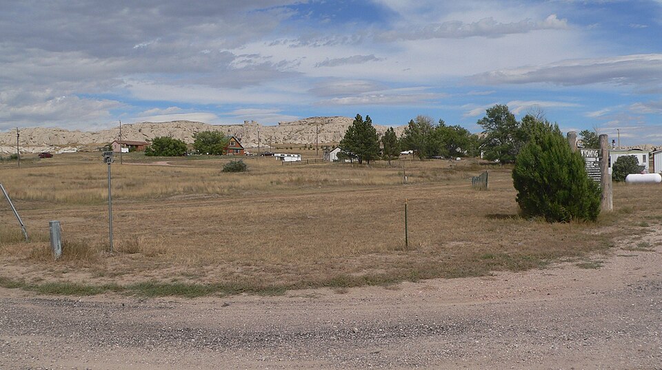
Photograph of Site of Ferdinand Branstetter Post No. 1, American Legion
Photograph by Ammodramus, CC0 1.0. Via Wikimedia Commons.

Site of Ferdinand Branstetter Post No. 1, American Legion

Listed on the National Register of Historic Places in 1969.

From the record

“The Site of Ferdinand Branstetter Post No. 1 of the American Legion is a vacant lot in Van Tassell, Wyoming where one of the first American Legion posts in the United States was established in 1919. The post was named after Ferdinand Branstetter, a Van Tassell resident who died in World War I.”

Wikipedia article Site of Ferdinand Branstetter Post No. 1, American Legion, CC BY-SA 4.0.

One of 4 National Register listings published here for Niobrara County · listed in 1969 · category: Site.

Sources: the Wikipedia article · the case file at the National Archives · the National Register database, National Park Service · the Wikipedia article

The listing

  • What is counted as historic. The nomination lists 1 site as contributing to the listing.
  • Address. US 20, Van Tassell, 82242
  • When was it listed? September 1969
  • Category. site
  • Census division. East Niobrara
  • National Register reference number. 69000194 - the number the National Park Service assigned this property when it was listed, and the key its nomination file is catalogued under at the National Archives.

Fires near this property

2 since 1996

Regional context, not property-specific evidence. The federal wildfire occurrence database lists 2 fires within 5 miles of Site of Ferdinand Branstetter Post No. 1, American Legion between 1996 and 2010, burning about 10 acres in total. 1 started naturally. None was recorded as arson. Distance is straight-line from the map coordinates, so a fire counted here may appear on a neighbouring settlement's page as well.

Reported cause Fires
Natural1
Missing data/not specified/undetermined1

The most recent of them, most recent first, with the day each was reported and the service that recorded it.

DateCause SizeReported by Name on the report
30 July 2010Natural4.0 acresNebraska Forest Servicenot named
1 April 1996Missing data/not specified/undetermined6.0 acresWyoming State Forestrynot named

Every fire recorded in Niobrara County

Storms near this property

13 since 1996

Regional context, not property-specific evidence. The National Weather Service names Van Tassell, the town this property stands in, in 13 storm reports between 1996 and 2024: 6 hail, 5 thunderstorm wind, 1 tornado, 1 flash flood. No death or injury is recorded in these reports. Each account below is quoted exactly as the forecast office filed it, from the NOAA Storm Events Database, and each date opens the federal record of that event.

WhenEvent Place namedHarm What the report says
June 2015Flash FloodVan Tassell$1,500,000As much as eight inches of rain fell from slow moving thunderstorms across south and southeast Niobrara County during the predawn hours, which resulted in widespread flash flooding. Excessive runoff upstream into the Niobrara River and nearby creeks caused them to overflow their banks. Law enforcement officials evacuated residents of Lusk as well as those living along the Niobrara River downstream to Van Tassel several hours in advance of the flood wave. The worst damage occurred in Lusk where 20 to 30 homes and 15 to 20 businesses were destroyed. Flood waters and debris rushed down Main Street in Lusk, swamped four blocks, and shut down the town's water supply. The US Highway 85 bridge on the north side of Lusk collapsed onto the railroad tracks below. Flash flooding closed a 20-mile stretch of US Highway 20 from Lusk to the Nebraska border, US Highway 85 from Lusk to the Goshen County line, and a 35-mile stretch of Highway 270 from Manville north to Lance Creek. WYDOT closed traffic into and out of Lusk, except for residents and emergency responders. Various state agencies, including the Red Cross and Wyoming National Guard, assisted in the flood cleanup efforts. A local command center was established at the Lusk Fairgrounds with water, food and shelter. The governor declared a state of emergency for Niobrara County. Fortunately, there were no injuries or fatalities.
July 2024Thunderstorm WindVan Tassell-WYDOT mesonet station along US Highway 20 near Van Tassell (WY60) reported wind gust.
June 2023HailVan Tassell-Trained weather spotters observed quarter sized hail 3 miles NNE of Van Tassel.
June 2021Thunderstorm WindVan Tassell-Wyoming Department of Transportation sensor along United States Highway 20 at Van Tassell measured the outflow winds from the thunderstorm to its east.
May 2021Thunderstorm WindVan Tassell-Wyoming Department of Transportation sensor three miles west of Van Tassell along United States Highway 20 measured the reported thunderstorm wind gust.
May 2021Thunderstorm WindVan Tassell-Wyoming Department of Transportation sensor located roughly three and a half miles from Van Tassell measured the reported wind speed.
July 2013HailVan Tassell-Golf ball size hail was reported north of Van Tassel.
May 2010HailVan Tassell-Trained spotter estimated hail of 1 inch in diameter fell with the storm.
May 1998Tornado (F0)Van Tassell-A brief tornado moved east across Highway 20 near Van Tassel before moving back up into the clouds.
June 2020HailVan Tassell-no account filed
June 2010HailVan Tassell-no account filed
July 1996HailVan Tassell-no account filed
July 1996Thunderstorm WindVan Tassell-no account filed

Every storm recorded in Niobrara County

Map coverage status

No historic map-sheet match is published for this property yet. That does not mean no map exists. This record needs a coordinate-quality review before it can be joined to a sheet boundary. Browse the county's mapped places while that work is pending.

Sources for this property

National Archives recordThe nomination case file for reference 69000194 in Record Group 79.
Wikipedia articleCommunity-written account of this property, licensed CC BY-SA.
Niobrara CountyAll 4 listed properties in this county.

Provenance

  • Listing record. National Park Service National Register of Historic Places, listed-properties dataset, current to 2026-05-22.
  • Map join. Address geocoded through the United States Census geocoder, then tested against the published boundary of every sheet in the USGS Historical Topographic Map Collection.
  • How this page is made. Listing fields come from federal records; map-sheet coverage is a labelled coordinate-to-boundary calculation, not a source-field claim.
  • Wildfire. Short, Karen C. 2022. Spatial wildfire occurrence data for the United States, 1992-2020 [FPA_FOD_20221014]. 6th Edition. Fort Collins, CO: Forest Service Research Data Archive. https://doi.org/10.2737/RDS-2013-0009.6 Collected with United States Government funding and usable without additional permissions or fees.
  • Storms. NOAA National Centers for Environmental Information, Storm Events Database https://www.ncei.noaa.gov/stormevents/ A work of the United States government, no copyright under 17 U.S.C. 105. Narratives are quoted verbatim from the National Weather Service report and are not edited or summarised.