
BlockBefore
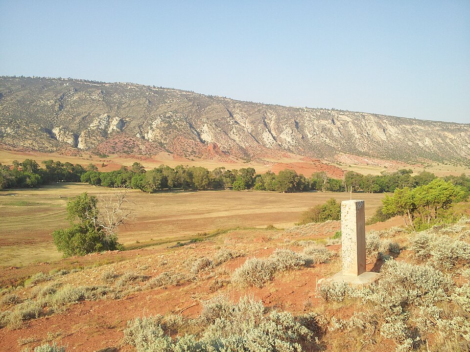
Photograph of Dull Knife Battlefield
Photograph by Caveman1949, CC BY-SA 3.0. Via Wikimedia Commons.

Dull Knife Battlefield

Listed on the National Register of Historic Places in 1979.

From the record

“The Dull Knife Battlefield is located on the eastern slope of the Bighorn Mountains in Johnson County, Wyoming near Kaycee. It was the scene of the Dull Knife Fight on November 25, 1876, in which the Fourth Cavalry under General Ranald S.”

Wikipedia article Dull Knife Battlefield, CC BY-SA 4.0.

One of 22 National Register listings published here for Johnson County · listed in 1979 · category: Site.

Sources: the Wikipedia article · the case file at the National Archives · the National Register database, National Park Service

The listing

  • Address. N of Barnum, Barnum, 82639
  • When was it listed? August 1979
  • Category. site
  • Census division. Kaycee
  • National Register reference number. 79002609 - the number the National Park Service assigned this property when it was listed, and the key its nomination file is catalogued under at the National Archives.

Fires near this property

34 since 1992

Regional context, not property-specific evidence. The federal wildfire occurrence database lists 34 fires within 5 miles of Dull Knife Battlefield between 1992 and 2019, burning about 393 acres in total. 31 started naturally. None was recorded as arson. Distance is straight-line from the map coordinates, so a fire counted here may appear on a neighbouring settlement's page as well.

Reported cause Fires
Natural31
Missing data/not specified/undetermined3

The most recent of them, most recent first, with the day each was reported and the service that recorded it.

DateCause SizeReported by Name on the report
9 September 2003Naturalunder an acreBuffalo Field OfficeGARDNER
8 September 1998Natural176 acresCasper Field OfficeGARDNER MT
7 September 1998Naturalunder an acreCasper Field OfficeCURUTCHET
3 September 2002Natural1.0 acresBuffalo Field OfficeLITTLE ANT
10 September 2009Natural2.0 acresBuffalo Field OfficeDEEP WELL
9 August 2013Naturalunder an acreBuffalo Field OfficeBOX ELDER RIDGE
9 August 2011Naturalunder an acreBuffalo Field OfficeBARNUM 1
9 August 2002Naturalunder an acreBuffalo Field OfficeEAGLES RST

Every fire recorded in Johnson County

Mines and quarries near this property

1 within 5 miles

Regional context, not property-specific evidence. The federal mineral resources record lists 1 working within 5 miles of Dull Knife Battlefield: 1 unknown. None of them still produces. What was taken out: Gypsum-Anhydrite. Distance is straight-line from the map coordinates, so a quarry counted here may appear on a neighbouring settlement's page as well.

Where SiteCommodity StatusRecorded
Red Fork # 2Gypsum-AnhydriteUnknown

Every working recorded in Johnson County

Storms near this property

17 since 1997

Regional context, not property-specific evidence. The National Weather Service names Barnum, the town this property stands in, in 17 storm reports between 1997 and 2023: 7 hail, 5 flash flood, 2 thunderstorm wind, 2 flood. No death or injury is recorded in these reports. Each account below is quoted exactly as the forecast office filed it, from the NOAA Storm Events Database, and each date opens the federal record of that event.

WhenEvent Place namedHarm What the report says
June 2023Flash FloodBarnum-See episode for a description.
September 2023Flash FloodBarnum-Reports to Sheriffs office of minor flooding across some of the dirt roads in southwestern portions of Johnson county.
June 2023HailBarnum-A supercell thunderstorm developed in the lee of the Bighorn range and brought large hail from Barnum to Kaycee. Hail the size of baseballs fell near Barnum with quarter size hail reported in Kaycee.
June 2022HailBarnum-A trained spotter reported quarter size hail near Barnum, WY.
May 2019FloodBarnum-NCRS employees reported minor to moderate flooding along the Middle Fork of the Powder River downstream from Barnum. The flooding remained over rural areas and caused no damage.
July 2019HailBarnum-A strong thunderstorm dropped penny sized hail in the vicinity of Barnum.
June 2017HailBarnum-A thunderstorm developed along the east side of the Bighorn Range and slowly strengthened. The storm became a supercell and dropped very large hail from Barnum to Kaycee. There were widespread reports of quarter size or bigger hail along the path. The largest report of hail was tennis ball size 5 miles southwest of Kaycee, not far from where a tornado developed. Hail up to the size of ping pong balls was reported in Barnum.
September 2014Thunderstorm WindBarnum-The Poker Creek RAWS site registered a wind gust to 59 mph.
July 2013Flash FloodBarnum-Heavy rain fell in and around Barnum producing minor flash flooding. Some mud and debris was deposited by the flood on Barnum Road, which was removed by a county grading crew. Beaver Creek overflowed its banks and flooded a few ranch fields. The inundation of water caused a five foot rise in about two hours on the Middle Fork of the Powder River.
July 2013HailBarnum-Penny sized hail was reported at a ranch south of Barnum.
July 2013Thunderstorm WindBarnum-Wind gusts estimated at 75 to 80 mph blew down several trees along the Bar C Ranch Road from Barnum to the Bar C Ranch.
July 2011Flash FloodBarnum-The public reported 1.9 of rain at the Blue Creek Ranch near Barnum. The creek was out of its banks and flooding property at the ranch. The creek was reportedly carrying a significant amount of debris out of a nearby canyon.
June 2010HailBarnum-One inch diameter hail was reported with a severe thunderstorm that formed along the southeast Bighorn Mountains.
June 2009Funnel CloudBarnum-Members of a Washakie County Road and Bridge crew observed a funnel cloud over the Big Horn Mountains west of Barnum. The crew was working near Cherry Creek Road in southeast Washakie County and observed the storm from the west.
June 2023FloodBarnum-no account filed
May 2000HailBarnum-no account filed
June 1997Flash FloodBarnum-no account filed

Every storm recorded in Johnson County

Map coverage status

No historic map-sheet match is published for this property yet. That does not mean no map exists. This record needs a coordinate-quality review before it can be joined to a sheet boundary. Browse the county's mapped places while that work is pending.

Sources for this property

National Archives recordThe nomination case file for reference 79002609 in Record Group 79.
Wikipedia articleCommunity-written account of this property, licensed CC BY-SA.
Johnson CountyAll 22 listed properties in this county.

Provenance

  • Listing record. National Park Service National Register of Historic Places, listed-properties dataset, current to 2026-05-22.
  • Map join. Address geocoded through the United States Census geocoder, then tested against the published boundary of every sheet in the USGS Historical Topographic Map Collection.
  • How this page is made. Listing fields come from federal records; map-sheet coverage is a labelled coordinate-to-boundary calculation, not a source-field claim.
  • Wildfire. Short, Karen C. 2022. Spatial wildfire occurrence data for the United States, 1992-2020 [FPA_FOD_20221014]. 6th Edition. Fort Collins, CO: Forest Service Research Data Archive. https://doi.org/10.2737/RDS-2013-0009.6 Collected with United States Government funding and usable without additional permissions or fees.
  • Mines and quarries. USGS Mineral Resources Data System (MRDS) https://mrdata.usgs.gov/mrds/ A work of the United States government, no copyright under 17 U.S.C. 105.
  • Storms. NOAA National Centers for Environmental Information, Storm Events Database https://www.ncei.noaa.gov/stormevents/ A work of the United States government, no copyright under 17 U.S.C. 105. Narratives are quoted verbatim from the National Weather Service report and are not edited or summarised.