
BlockBefore
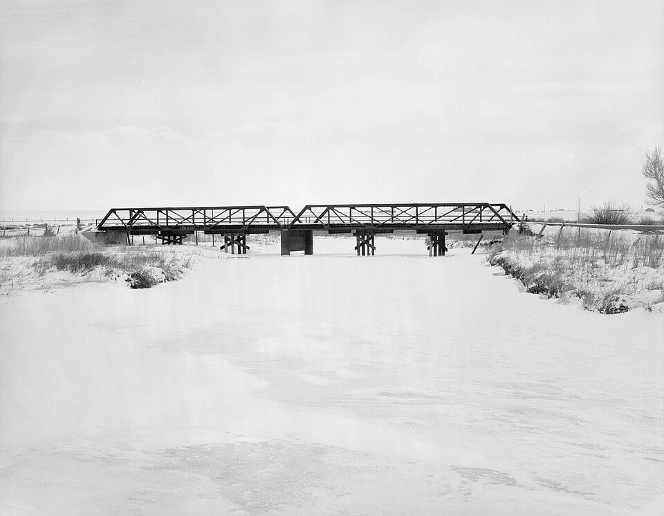
Photograph of DOE Bridge over Laramie River
Photograph by Clayton B. Fraser, Public domain. Via Wikimedia Commons.

DOE Bridge over Laramie River

Listed on the National Register of Historic Places in 1985.

From the record

“The DOE Bridge over Laramie River was a Pratt half-hip pony truss bridge located near Bosler, Wyoming, which carried Albany County Road CNA-740 across the Laramie River. The bridge was built in 1926 by contractor N.”

Wikipedia article DOE Bridge over Laramie River, CC BY-SA 4.0.

One of 42 National Register listings published here for Albany County · listed in 1985 · category: Structure.

Sources: the Wikipedia article · the case file at the National Archives · the National Register database, National Park Service

The listing

  • What is counted as historic. The nomination lists 1 structure as contributing to the listing.
  • Address. Cty. Rd. CNA-740, Bosler, 82051
  • When was it listed? February 1985
  • Category. structure
  • Also known as. Vehicular Truss and Arch Bridges in Wyoming TR
  • Census division. East Albany
  • National Register reference number. 85000411 - the number the National Park Service assigned this property when it was listed, and the key its nomination file is catalogued under at the National Archives.

Fires near this property

4 since 1994

Regional context, not property-specific evidence. The federal wildfire occurrence database lists 4 fires within 5 miles of DOE Bridge over Laramie River between 1994 and 2018, burning about 9 acres in total. None started naturally. None was recorded as arson. Distance is straight-line from the map coordinates, so a fire counted here may appear on a neighbouring settlement's page as well.

Reported cause Fires
Missing data/not specified/undetermined3
Debris and open burning1

The most recent of them, most recent first, with the day each was reported and the service that recorded it.

DateCause SizeReported by Name on the report
10 July 2016Missing data/not specified/undetermined1.0 acresWyoming State Forestrynot named
6 June 2018Missing data/not specified/undetermined1.0 acresCrook CountyBOSLER FIRE
15 May 2012Debris and open burning7.0 acresWyoming State ForestryBOSLER FIRE
1 October 1994Missing data/not specified/undeterminedunder an acreWyoming State Forestrynot named

Every fire recorded in Albany County

Storms near this property

14 since 1994

Regional context, not property-specific evidence. The National Weather Service names Bosler, the town this property stands in, in 14 storm reports between 1994 and 2025: 9 hail, 3 tornado, 1 funnel cloud, 1 flash flood. No death or injury is recorded in these reports. Each account below is quoted exactly as the forecast office filed it, from the NOAA Storm Events Database, and each date opens the federal record of that event.

WhenEvent Place namedHarm What the report says
July 2025HailBosler-Report from mPING of quarter size hail.
July 2019Tornado (EF1)Bosler-A supercell thunderstorm developed near the town of Rock River, Wyoming, in west-central Albany County. At 606 PM MDT, the storm rapidly intensified as it moved southeast. A tornado touched down and crossed Highway 30 south of Bosler, Wyoming at 610 PM MDT, and dissipated at 619 PM MDT. The storm continued to show signs of rotation as it moved east-southeast toward the Laramie County line, however no additional tornadoes were reported.||A survey team from the National Weather Service in Cheyenne met with officials from Albany County to investigate storm damage in the Bosler area. Eyewitness reports and snapped wooden power poles along County Road 51 indicated the initial tornado touched down in an open field about 2.5 miles west-southwest of Bosler, or 18.5 miles north-northwest of Laramie. The tornado lifted for a short time but descended again and caused complete destruction of a pole barn near Highway 30 about three miles south-southeast of Bosler. The tornado crossed Highway 30, confirmed by aerial photographs provided by the City of Laramie. Large pieces of warped metal were blown several hundred yards to the east of the highway in a wide swath. The damage footprint ended near the point of the original report. Damage was consistent with an EF-1 tornado with maximum winds around 100 mph.
July 2015HailBosler-Half dollar size hail was observed ten miles northwest of Iron Mountain.
June 2015HailBosler-Quarter size hail was observed at Bosler.
May 2015Tornado (EF0)Bosler-A weak tornado touched down in open country eight miles west-northwest of Bosler and moved northwest at 15 mph. The tornado was on the ground for five minutes then dissipated. No damage was reported.
June 2015HailBosler-Golf ball size hail was reported 16 miles north-northwest of Iron Mountain.
June 2014HailBosler-Quarter size hail was observed six miles north of Baldy Peak.
August 2013Flash FloodBosler-Flash flooding occurred along Highway 34 between mile markers 19 and 27 northeast of Bosler. A mudslide was reported at mile marker 22 about three miles southwest of the Sybille Wildlife Research Center.
July 2013HailBosler-Penny to quarter size hail was reported west of Bosler.
August 1997Funnel CloudBosler-Two funnel clouds reported.
July 2019HailBosler-no account filed
August 2002HailBosler-no account filed
May 1996HailBosler-no account filed
July 1994Tornado (F0)Bosler-no account filed

Every storm recorded in Albany County

Map coverage status

No historic map-sheet match is published for this property yet. That does not mean no map exists. This record needs a coordinate-quality review before it can be joined to a sheet boundary. Browse the county's mapped places while that work is pending.

Sources for this property

National Archives recordThe nomination case file for reference 85000411 in Record Group 79.
Wikipedia articleCommunity-written account of this property, licensed CC BY-SA.
Albany CountyAll 42 listed properties in this county.

Provenance

  • Listing record. National Park Service National Register of Historic Places, listed-properties dataset, current to 2026-05-22.
  • Map join. Address geocoded through the United States Census geocoder, then tested against the published boundary of every sheet in the USGS Historical Topographic Map Collection.
  • How this page is made. Listing fields come from federal records; map-sheet coverage is a labelled coordinate-to-boundary calculation, not a source-field claim.
  • Wildfire. Short, Karen C. 2022. Spatial wildfire occurrence data for the United States, 1992-2020 [FPA_FOD_20221014]. 6th Edition. Fort Collins, CO: Forest Service Research Data Archive. https://doi.org/10.2737/RDS-2013-0009.6 Collected with United States Government funding and usable without additional permissions or fees.
  • Storms. NOAA National Centers for Environmental Information, Storm Events Database https://www.ncei.noaa.gov/stormevents/ A work of the United States government, no copyright under 17 U.S.C. 105. Narratives are quoted verbatim from the National Weather Service report and are not edited or summarised.