 Block
From the record
10 National Register listings published here.
Sources: the National Register database, National Park Service
49 topographic sheets cover 25 settlements here, and 10 properties are on the National Register of Historic Places.
10 National Register listings published here.
Sources: the National Register database, National Park Service
Every property in this county listed on the National Register of Historic Places, with the year it was listed and the federal nomination document.
| Photograph | Property | Type | Listed | Reference |
|---|---|---|---|---|
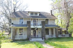 | P.D. Burton House | building | 1998 | 98000612 |
| Conway Cemetery | site | 1977 | 77000259 | |
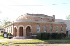 | First Methodist Church | building | 1996 | 96000639 |
 | First Presbyterian Church | building | 1996 | 96000640 |
| Gulf Oil Company Filling Station | building | 2019 | 100003331 | |
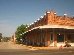 | King-Whatley Building | building | 1978 | 78000603 |
 | Lafayette County Courthouse | building | 1993 | 93000085 |
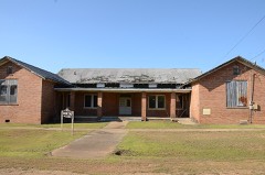 | Lafayette County Training School | building | 2005 | 04001500 |
 | Peoples Bank and Loan Building | building | 1996 | 96000637 |
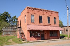 | Triplett Company Building | building | 1996 | 96000638 |
Every wildfire the federal occurrence database records inside this county: 447 of them, burning about 6,862 acres. 38 started naturally and 92 were recorded as arson. Each settlement page carries the fires within five miles of it.
| Reported cause | Fires |
|---|---|
| Missing data/not specified/undetermined | 169 |
| Debris and open burning | 99 |
| Arson/incendiarism | 92 |
| Natural | 38 |
| Equipment and vehicle use | 24 |
| Smoking | 12 |
| Railroad operations and maintenance | 7 |
| Misuse of fire by a minor | 4 |
| Recreation and ceremony | 2 |
The five largest, by the area the report gives. 7 of them were set deliberately.
| Date | Cause | Size | Reported by | Name on the report |
|---|---|---|---|---|
| 1 January 2006 | Arson/incendiarism | 309 acres | Arkansas Forestry Commission | not named |
| 25 September 1999 | Arson/incendiarism | 290 acres | Arkansas Forestry Commission | not named |
| 15 September 2010 | Arson/incendiarism | 244 acres | Arkansas Forestry Commission | LAKE ERLING |
| 3 August 2008 | Arson/incendiarism | 240 acres | Arkansas Forestry Commission | LAFAYETTE 1 |
| 13 June 2018 | Missing data/not specified/undetermined | 224 acres | Arkansas Forestry Commission | not named |
| 2 July 2011 | Arson/incendiarism | 163 acres | Arkansas Forestry Commission | GREEN |
| 17 September 2000 | Arson/incendiarism | 160 acres | Arkansas Forestry Commission | not named |
| 8 January 2006 | Arson/incendiarism | 160 acres | Arkansas Forestry Commission | not named |
Every settlement page carries the fires within five miles of it - see the settlement index below.
The NOAA Storm Events Database holds 422 reports for this county, causing 1 death, 5 injuries and about $4,456,030 in recorded property damage. Each settlement page carries the reports that name it.
| Kind of event | Reports |
|---|---|
| Thunderstorm Wind | 203 |
| Hail | 142 |
| Flash Flood | 52 |
| Tornado | 19 |
| Flood | 3 |
| Funnel Cloud | 1 |
| Heat | 1 |
| Heavy Rain | 1 |
The most serious of them, by death, then injury, then recorded damage. The accounts are quoted exactly as the forecast office filed them.
| When | Event | Place named | Harm | What the report says |
|---|---|---|---|---|
| October 2009 | Flood | Lake Erling | 1 killed | A 30 year old Shongaloo, Louisiana woman drowned during the evening of Tuesday, October 27th in Lake Erling, Arkansas. The woman attempted to go over the spillway on a futon mattress and was supposedly going to ride it on the flood waters running over the spillway. There was approximately 2.5 feet of water going over the spillway at the time. The woman's body was found the next day approximately 75 yards from the spillway. She was caught on the top of a willow tree almost totally submerged by the water. |
| June 2004 | Thunderstorm Wind | Stamps | 2 hurt | Tree blown onto a car trapping two people inside. |
| June 2003 | Thunderstorm Wind | Lewisville | 1 hurt, $29,000 | Strong winds that roared through the county contributed to an accident on CR 5 north. According to Lafayette County Chief Deputy, the accident occurred when a 1995 Pontiac Grand Prix driven by Maxine Matlock, 40 was headed west from Highway 29 North. The strong winds caused a large tree to fall across the road near Union Hill Church. Matlock was unable to stop before branches from the large tree struck the front of the vehicle and entered the windshield. Matlcok skidded 39 feet before impact and then traveled an additional 12 feet before coming to a stop. Only one injury was reported. |
| October 2009 | Thunderstorm Wind | Bradley | 1 hurt, $10,000 | A tree was blown down onto a vehicle trapping a man inside. He was injured and taken to a local hospital. |
| April 2024 | Thunderstorm Wind | State Line | 1 hurt | An occupant inside a home on County Road 245 on the south side of Lake Erling was hospitalized with non-life threatening injuries due to a large tree falling onto the home. |
| April 2000 | Tornado (F1) | Pleasant Vly | $1,200,000 | Farm barns and outbuildings with light to moderate damage, farm trailers moderate damaged or destroyed, chicken houses destroyed, numerous trees and power poles downed, 3 mobile homes damaged. |
| June 2015 | Flood | Hurricane Hill | $500,000 | Excessive heavy rainfall during the month of May resulted in very high water on the Red River bordering Little River, Hempstead, Miller and Lafayette Counties in Southwest Arkansas as well as Bowie County in Northeast Texas during the entire month of June. Rainfall amounts during the month of May across the Upper and Middle Red River basins of Southern Oklahoma and Northern Texas totaled over 20 inches of rain. The Oklahoma state climatologist reported that May of 2015 was the all time wettest month of any month in state history. Lake Texhoma, a flood control reservoir to the Red River upstream of Arthur City, Texas rose to its highest pool stage on record early on June 1st at 645.66 feet with peak releases of around 140,000 CFS. The Muddy Boggy Creek tributary to the Red River rose to near its flood of record cresting near 55 feet earlier on May 29th with inflows upwards of 70,000 CFS into the Red River. Muddy Boggy Creek crested just shy of the 1990 flood of record with 55.27 feet near Unger, Oklahoma. Other tributaries of the Red River also crested at very high levels during the final week of May and early in June, 2015 below Lake Texhoma including Bois D'Arc and Bokchito Creeks. Finally the Kiamichi River at Hugo Reservoir crested just below a new pool stage record after May 25th and contributed peak releases of near 60,000 CFS as well to the Red River. This excessive heavy rainfall and inflow into the Red River resulted river levels that eclipsed the flood of May of 1990 at Pecan Point and was just shy of the Red River flood of May of 1908 at Pecan Point. The Red River at Pecan Point north of Dekalb, Texas went above the 24 foot flood stage on May 10th, 2015 and remained above that flood stage through the entire month of June and did not fall below flood stage until until July, 2015. The Red River at Pecan Point north of Dekalb, Texas went above the 30 foot major flood stage on May 24th, 2015 and crested at a stage of 35.0 feet on June 2nd, 2015. This is the 3rd highest crest in recorded history at the gauging location, eclipsed only by the flood of record of 36.0 feet in 1938 and 35.5 feet in 1908. The river fell below the 30 foot major flood stage on June 10th. A secondary rise on the Red River developed because of excessive heavy rainfall once again in the middle Red River Basin from the remnants of Tropical Storm Bill. As a result, the Red River at Pecan Point north of Dekalb, Texas went back above the 30 foot major flood stage on June 22nd and crested at a stage of 32.5 feet on June 24th. The Red River then fell below the 30 foot major flood stage on June 28th. Below Pecan Point north of Dekalb, Texas, the Red River at Index, Arkansas crested at 31.4 feet on June 3rd. This was the 3rd highest flood at Index, Arkansas in recorded history at the gauging location, eclipsed only by the flood of record of 34.4 feet in 1938 and 32.3 feet in 1990. The river fell below the 28 foot major flood stage on June 8th. A secondary rise on the Red River developed because of excessive heavy rainfall once again in the middle Red River Basin from the remnants of Tropical Storm Bill. As a result, the Red River at Index, Arkansas crested again at 26.6 feet on June 27th and fell below the 25 foot flood stage on June 29th. Below Index, Arkansas, the Red River at Fulton, Arkansas crested at 32.12 feet on June 5th. This was the 11th highest flood at Fulton, Arkansas in recorded history at the gauging location with the record crest of 37.40 having occurred in 1945. The river fell below the 27 foot flood stage on June 10th. A secondary rise on the Red River developed because of excessive heavy rainfall once again in the middle Red River Basin from the remnants of Tropical Storm Bill. As a result, the Red River at Fulton, Arkansas crested again at 25.1 feet on June 27th which was nearly two feet short of the 27 foot flood stage at Fulton, Arkansas. Bank erosion was extreme on the Lafayette County side of the Red River with 43 thousand acres of farmland and pastureland inundated. 600 head of cattle were lost and hundreds of others had to be relocated. Total crop loss including corn, mixed forage, rice, soybean, wheat and warn season grasses was estimated to be near 13 million dollars. There were near 200 farms that suffered some physical damage from flooding with damage to those structures totaling near 500 thousand dollars. Farm equipment damage totaled near 20 thousand dollars. The United States Highway 259 bridge, Hwy 8 bridge and the Hwy. 71 bridge going over the Red River were closed. Highway 360 Section 0A at log mile 4 west of Bradley, Arkansas was also closed. |
| October 2009 | Thunderstorm Wind | Bradley | $500,000 | Upwards of 20 homes wee damaged across the southern half of Lafayette County, Arkansas from thunderstorms winds. The homes were damaged from fallen trees. There were no reports of injuries across the county. Areas around Lake Erling were especially hit hard as trees and powerlines blocked roads and across to some residential areas. At least a mile of Hwy. 53 was littered with debris which had to be removed before emergency personnel could assist a motorist trapped in his truck by a tree tangled in high voltage power lines. One home positioned a the edge of the lake on Laf. 260 had the roof stripped. Another large tree fell on a truck and the tree also clipped an adjacent home. Three trees were also downed on mobile homes in the area. At Sandy Point, it was estimated that three-fourths of the homes had some type of damage. At Cypress Point, most of the homes were reported to have some type of storm damage ranging from roof damage, downed trees, broken windows, dented walls and damaged vehicles. |
| October 2009 | Flash Flood | Lewisville Arpt | $250,000 | Hwy. 82 east of Lewisville was closed due to 3 feet of water over the highway. During the height of the storm, the County Judge said that there were only 3 roads in the county that did not have high water over them. So many roads were flooded that the county ran out of barricades, high water and street closed signs. Several cars were flooded and stalled in high water and a woman and child had to be pulled from one car. Some of the major flooding occurred on highways 313 and 53 as well as County Roads 31, 60, 26, 22, 16 and 18. Several homes in the Lewisville area were flooded forcing the evacuation of several people. The rushing water eroded gravel roads, washed out culverts and stranded many residents. Lafayette County was one of 20 counties across the state that were declared disaster areas from rainfall up to the 13th, 14th and 15th of October. |
| October 1974 | Tornado (F1) | not stated | $250,000 | no account filed |
| May 2020 | Tornado (EF1) | Lewisville Arpt | $200,000 | An EF-1 tornado with estimated maximum winds around 100 mph briefly touched down along a wooded area on the northern fringes of the town of Lewisville, and moved west northwest across the south parking lot of the M&M Quick Stop before crossing Highway 29. Several trees were snapped and uprooted, and a power pole was snapped along Highway 29 before crossing the roadway into a residential area. This tornado continued to snap and uproot several more trees just north of West 13th Street, with a large pine tree falling onto the First Assembly of God Church, as well as through the middle of a single family home on Cherry Street. The tornado snapped a few more trees along North Murphy Street, with a tree falling through a mobile home at the end of the roadway before lifting in a heavily wooded area. |
| April 2025 | Tornado (EF1) | Canale | $135,000 | A strong EF-1 tornado with estimated maximum winds near 110 mph touched down along the Red River along the Miller/Lafayette County line, and tracked northeast across an open pasture and a levee just west of Lafayette County Road 57, where it snapped and uprooted several trees. The tornado then tracked across Lafayette County Roads 57 and 47, before moving across open farmland as it moved northeast towards Highway 160 west of Gin City. The Lafayette County Emergency Manager visually confirmed that the tornado remained on the ground across the open farmland, before snapping 7 wooden power poles along Highway 160 just west of Gin City. The tornado again moved across open farmland to the northwest of Gin City, before snapping 3 additional wooden power poles and a couple of trees, while ripping a small portion of a metal roof off of a home. The tornado lifted near a grove of trees behind Pleasant Valley Mennonite Church. |
| April 2014 | Thunderstorm Wind | Lewisville | $125,000 | The NWS conducted a storm survey and concluded that the damage across Lafayette county was consistent with that of straight line winds produced by a bow echo. State Police estimated wind gusts to near 70 mph with the storm that knocked down numerous trees and powerlines. Other damage consisted of damaged fences, numerous garages and outbuilding damage as well as shingles of several roofs. |
| August 2006 | Thunderstorm Wind | Lewisville | $80,000 | Thunderstorm winds blew the roof off a mobile home, caused minor damage to a school roof and damaged two stores in town. |
| October 2009 | Thunderstorm Wind | Buckner | $75,000 | NWS storm survey determined that a downburst occurred north of Buckner, Arkansas, and produced widespread wind damage over a concentrated area. Two chicken houses were severely damaged on the north side of County Road 31 and Hwy. 53. Nine trees were uprooted across Hwy. 53 and a passenger vehicle was struck by one of the fallen trees which trapped the occupants inside. There were no report of any injuries. |
| May 2003 | Hail | Lewisville | $60,000 | Hailstones ranging from dime size to baseball size fell producing thousands of dollares in damage to automobiles according to the Emergency Manager. |
| July 2024 | Tornado (EF1) | Canale | $55,000 | This is a continuation of the Northern Bossier Parish tornado. This EF-1 tornado, with maximum estimated winds near 105 mph, tracked north into extreme Southwest Lafayette County just east of County Road 1, where it remained over mainly open farmland before damaging 6 power poles just south of the intersection of County Road 1 and Lafayette 47. Two of these power poles were snapped, which resulted in the 105 mph estimated maximum wind rating, before the tornado crossed Lafayette 47 across a corn field where it laid out a 50 yard wide section of corn. Pictures and video were taken of the tornado over open farmland before lifting about 300 yards southwest of a farm along Highway 160 west of Gin City. This same storm was part of a multi-vortex tornado, with a second tornado having produced minor damage about 3/4 mile to the west along Lafayette 47. |
| April 2025 | Tornado (EF1) | Lake Erling | $50,000 | A brief EF-1 tornado with estimated maximum winds near 95 mph touched down over a wooded area just west of Highway 53 and just south of Lafayette Road 249, where multiple trees were uprooted. This tornado crossed Highway 53 and snapped/uprooted several additional trees and tree tops before lifting. |
| April 2024 | Tornado (EF1) | Canale | $50,000 | A brief EF-1 tornado with estimated maximum winds near 110 mph touched down and tracked east along and just south of County Road 7 in the far southwestern portion of Lafayette County. Despite its short path, the tornado produced higher end EF-1 damage with maximum estimated wind speeds attributed to snapping of power poles and the near destruction of a metal barn housing hay bales. Otherwise, damage was mostly limited to trees in the form of uproots, trunk snaps, and downing of large limbs. |
| April 2024 | Tornado (EF1) | Kizer | $50,000 | A brief EF-1 tornado with estimated maximum winds near 90 mph touched down and tracked northeast to the west of Lake Erling, starting along Hood Road and lifting just after crossing Highway 160. The tornado could have begun slightly before Hood Road, but many trees crossing that road limited the survey team's access farther to the southwest. Damage was mostly to trees in the form of uproots, trunk snaps, and downing of large limbs. ||There were also a multitude of trees downed to the northeast in a widespread area around Lake Erling. Some trees produced structural damage as they fell on residences and the damage was attributed to straight line winds of 60 to 80 mph, not the tornado. |
| January 2013 | Thunderstorm Wind | Stamps | $50,000 | A roof was blown off a house. Numerous trees were downed and a mobile home was damaged. |
| May 1994 | Thunderstorm Wind | Walnut Hill | $50,000 | Thunderstorm winds blew down numerous trees along Highway 160 near Walnut Hill. |
| June 1994 | Thunderstorm Wind | Stamps | $50,000 | Thunderstorm winds blew down trees and damaged a chicken house. |
| November 1994 | Thunderstorm Wind | Bradley | $50,000 | Trees and power lines were blown down. Two houses sustained roof damage and windows were blown out of a store. |
| November 1994 | Thunderstorm Wind | Bradley | $50,000 | Thunderstorm winds damaged two houses and downed some trees. |
| October 1993 | Thunderstorm Wind | Canfield | $50,000 | Thunderstorm winds downed numerous trees. |
| April 1993 | Thunderstorm Wind | Canfield | $50,000 | Thunderstorm winds knocked down numerous trees. |
| May 1993 | Thunderstorm Wind | Murfreesboro | $50,000 | Numerous trees were blown down. |
| May 1993 | Thunderstorm Wind | down by | $50,000 | Numerous trees were blown down. |
| August 1993 | Thunderstorm Wind | Lewisville | $50,000 | Thunderstorm winds downed numerous trees. |
| October 1993 | Thunderstorm Wind | Stamps | $50,000 | Some trees were knocked down and one house sustained roof damage. |
| October 2001 | Flash Flood | Lewisville | $30,000 | Several homes were flooded in town and several county roads were closed from high waters. |
| October 2010 | Thunderstorm Wind | Mc Kamie | $25,000 | A roof was blown off a home and major tree damage was reported around a home on Lafayette County Road 41 south of Stamps, Arkansas. |
| May 2009 | Flash Flood | Lewisville | $25,000 | Several rural roads were flooded and closed across the county. Highway department reported that nearly 30 culverts were washed out and 75 to 80 percent of those will have to be repaired. |
| March 1963 | Tornado (F2) | not stated | $25,000 | no account filed |
| October 2010 | Thunderstorm Wind | Buckner | $20,000 | Trees were downed and a building was damaged along Hwy. 53 north of Buckner, Arkansas. |
| April 2010 | Thunderstorm Wind | Stamps | $20,000 | A huge oak tree fell across a residents driveway crushing a truck and rested beside the house. |
| March 2007 | Tornado (EF0) | Lewisville | $20,000 | A line of severe thunderstorms spawned a tornado along the northern edge of the line of thunderstorms. The tornado touched down northwest of Lewisville, Arkansas with damage consisting of a chicken house and several trees that were snapped and uprooted. The tornado was rated an EF0 on the Enhanced Fujita Scale. Damage Indicator (DI): Small barns or outbuildings. Degree of Damage (DOD): Loss of wood or metal roof panels. |
| July 2023 | Tornado (EF1) | Stamps | $15,000 | An EF-1 tornado with estimated maximum winds near 93 mph touched down just south of Stamps in Eastern Lafayette County along Highway 53 (McKamie Road) between Lakeside Cemetery and Lake June. There were a number of trees that were snapped and uprooted just east of Lake June near the parking lot, with a large tree snapped across the road at the cemetery. The tornado then tracked south along Highway 53 where additional tree damage occurred near Ferguson Hill Road and Hamilton Street, before strengthening from Fuller Drive south to County Road 84 where EF-1 damage was observed. The tornado continued to track south across County Road 85 and County Road 23 before lifting near Highway 53 just south of County Road 23. |
| October 2019 | Tornado (EF1) | State Line | $10,000 | An EF-1 tornado with estimated maximum winds around 100 mph touched down near the intersection of Highway 53 and County Road 21 in far Southeast Lafayette County just north of the Louisiana state line, where it partially removed the roof and siding from an outbuilding. The tornado continued east along County Road 21 where it entered Southwest Columbia County. |
| December 2012 | Thunderstorm Wind | Stamps | $10,000 | A tree was downed onto a car in the Stamps community. No injuries were reported. |
| March 1998 | Hail | Lewisville | $10,000 | Vehicles travelling along Hwy 79 had their windshields and antennas broken or damaged by hail. |
| June 2003 | Thunderstorm Wind | Lewisville | $8,000 | A tree fell on a home along Highway 29 while another home suffered wind damage. Metal poles holding bird houses were bent in half by the strong winds. |
| April 2009 | Thunderstorm Wind | Gin City | $5,000 | A trailer was overturned near the community of Gin City, Arkansas. |
| May 2009 | Thunderstorm Wind | Spirit Lake | $5,000 | Estimated 70 mph winds along Hwy. 82 west of town. Trees were also reported down across Hwy. 29 south of Bradley. A tree was down on powerlines and the roadway on Buchanan Street in Stamps. A couple of trees were downed on powerlines on Hwy. 53 south of Stamps. A tree was downed on Lafayette Road 59. In addition, a vehicle hit a fallen tree on the roadway west of Bradley, Arkansas. |
| January 1994 | Thunderstorm Wind | Lewisville | $5,000 | Thunderstorm winds blew down some trees. |
| October 1994 | Thunderstorm Wind | Canfield | $5,000 | Several trees were knocked down. |
| May 1994 | Thunderstorm Wind | Gin City | $5,000 | Thunderstorm winds knocked down some trees. |
| June 1994 | Thunderstorm Wind | Gin City | $5,000 | Thunderstorm winds blew the windows out of a convenience store and damaged a barn. |
| October 1994 | Thunderstorm Wind | Kress City | $5,000 | Thunderstorm winds blew down some trees. |
| November 1994 | Thunderstorm Wind | Stamps | $5,000 | Several trees were blown down. |
| November 1994 | Thunderstorm Wind | Canfield | $5,000 | Thunderstorm winds downed several trees. |
| November 1994 | Thunderstorm Wind | Stamps | $5,000 | Thunderstorm winds knocked down several trees. |
| October 1993 | Thunderstorm Wind | Canfield | $5,000 | Thunderstorm winds blew down several trees. |
| October 1993 | Thunderstorm Wind | Hope | $5,000 | Thunderstorm winds blew down several large tree limbs. |
| October 1993 | Thunderstorm Wind | Prescott | $5,000 | no account filed |
| June 2004 | Thunderstorm Wind | Buckner | $2,000 | Roof damage to two chicken houses. |
| May 2007 | Thunderstorm Wind | Bradley | $1,000 | Trees were downed west of town along with the tin roof damage to some outbuildings. |
| June 1994 | Thunderstorm Wind | Bradley | $500 | Several trees were blown down by thunderstorm winds. |
| October 1993 | Thunderstorm Wind | Lewisville | $500 | Thunderstorm winds blew down several large tree limbs. |
The Survey's mineral resources record lists 91 workings inside this county. 4 still produce and 87 are closed or unrecorded. Each settlement page carries the workings within five miles of it.
| Commodity | Workings |
|---|---|
| Sand and Gravel, Construction | 84 |
| Iron | 3 |
| Clay | 2 |
| Silica | 1 |
| Sulfur | 1 |
The least common of them first, because a county's hundredth gravel pit says nothing its first ten did not.
| Where | Site | Commodity | Status | Recorded |
|---|---|---|---|---|
| McKamie Sulfur Plant | Sulfur | Producer | ||
| Unk | Silica | Past Producer | ||
| Claiborn Group | Clay | Unknown | ||
| Wilcox Group | Clay | Unknown | ||
| Unk | Iron | Past Producer | ||
| Unk | Iron | Past Producer | ||
| Unk | Iron | Past Producer | ||
| Barr Pit | Sand and Gravel, Construction | Producer | ||
| Buelar Pit | Sand and Gravel, Construction | Past Producer | ||
| Gifford-Hill & Co | Sand and Gravel, Construction | Unknown | ||
| Herndon & Buehler Pit No 1 | Sand and Gravel, Construction | Producer | ||
| Landers Pit | Sand and Gravel, Construction | Past Producer | ||
| Lewisville Pit | Sand and Gravel, Construction | Past Producer | ||
| Malvern | Sand and Gravel, Construction | Past Producer | ||
| Mc Kamie | Sand and Gravel, Construction | Past Producer | ||
| Meriwether Sand & Gravel Co | Sand and Gravel, Construction | Past Producer | ||
| Newton Pit | Sand and Gravel, Construction | Past Producer | ||
| Stevens Brothers Sand And Gravel | Sand and Gravel, Construction | Past Producer | Surface | |
| Unk | Sand and Gravel, Construction | Past Producer | ||
| Unk | Sand and Gravel, Construction | Past Producer | ||
| Unk | Sand and Gravel, Construction | Past Producer | ||
| Unk | Sand and Gravel, Construction | Producer | ||
| Unk | Sand and Gravel, Construction | Past Producer | ||
| Unk | Sand and Gravel, Construction | Past Producer | ||
| Unk | Sand and Gravel, Construction | Past Producer | ||
| Unk | Sand and Gravel, Construction | Past Producer | ||
| Unk | Sand and Gravel, Construction | Past Producer | ||
| Unk | Sand and Gravel, Construction | Past Producer | ||
| Unk | Sand and Gravel, Construction | Past Producer | ||
| Unk | Sand and Gravel, Construction | Past Producer | ||
| Unk | Sand and Gravel, Construction | Past Producer | ||
| Unk | Sand and Gravel, Construction | Past Producer | ||
| Unk | Sand and Gravel, Construction | Past Producer | ||
| Unk | Sand and Gravel, Construction | Past Producer | ||
| Unk | Sand and Gravel, Construction | Past Producer | ||
| Unk | Sand and Gravel, Construction | Past Producer | ||
| Unk | Sand and Gravel, Construction | Past Producer | ||
| Unk | Sand and Gravel, Construction | Past Producer | ||
| Unk | Sand and Gravel, Construction | Past Producer | ||
| Unk | Sand and Gravel, Construction | Past Producer | ||
| Unk | Sand and Gravel, Construction | Past Producer | ||
| Unk | Sand and Gravel, Construction | Past Producer | ||
| Unk | Sand and Gravel, Construction | Past Producer | ||
| Unk | Sand and Gravel, Construction | Past Producer | ||
| Unk | Sand and Gravel, Construction | Past Producer | ||
| Unk | Sand and Gravel, Construction | Past Producer | ||
| Unk | Sand and Gravel, Construction | Past Producer | ||
| Unk | Sand and Gravel, Construction | Past Producer | ||
| Unk | Sand and Gravel, Construction | Past Producer | ||
| Unk | Sand and Gravel, Construction | Past Producer | ||
| Unk | Sand and Gravel, Construction | Past Producer | ||
| Unk | Sand and Gravel, Construction | Past Producer | ||
| Unk | Sand and Gravel, Construction | Past Producer | ||
| Unk | Sand and Gravel, Construction | Past Producer | ||
| Unk | Sand and Gravel, Construction | Past Producer | ||
| Unk | Sand and Gravel, Construction | Past Producer | ||
| Unk | Sand and Gravel, Construction | Past Producer | ||
| Unk | Sand and Gravel, Construction | Past Producer | ||
| Unk | Sand and Gravel, Construction | Past Producer | ||
| Unk | Sand and Gravel, Construction | Past Producer | ||
| Unk | Sand and Gravel, Construction | Past Producer | ||
| Unk | Sand and Gravel, Construction | Past Producer | ||
| Unk | Sand and Gravel, Construction | Past Producer | ||
| Unk | Sand and Gravel, Construction | Past Producer | ||
| Unk | Sand and Gravel, Construction | Past Producer | ||
| Unk | Sand and Gravel, Construction | Past Producer | ||
| Unk | Sand and Gravel, Construction | Past Producer | ||
| Unk | Sand and Gravel, Construction | Past Producer | ||
| Unk | Sand and Gravel, Construction | Past Producer | ||
| Unk | Sand and Gravel, Construction | Past Producer | ||
| Unk | Sand and Gravel, Construction | Past Producer | ||
| Unk | Sand and Gravel, Construction | Past Producer | ||
| Unk | Sand and Gravel, Construction | Past Producer | ||
| Unk | Sand and Gravel, Construction | Past Producer | ||
| Unk | Sand and Gravel, Construction | Past Producer | ||
| Unk | Sand and Gravel, Construction | Past Producer | ||
| Unk | Sand and Gravel, Construction | Past Producer | ||
| Unk | Sand and Gravel, Construction | Past Producer | ||
| Unk | Sand and Gravel, Construction | Past Producer | ||
| Unk | Sand and Gravel, Construction | Past Producer | ||
| Unk | Sand and Gravel, Construction | Past Producer | ||
| Unk | Sand and Gravel, Construction | Past Producer | ||
| Unk | Sand and Gravel, Construction | Past Producer | ||
| Unk | Sand and Gravel, Construction | Past Producer | ||
| Unk | Sand and Gravel, Construction | Past Producer | ||
| Unk | Sand and Gravel, Construction | Past Producer | ||
| Unk | Sand and Gravel, Construction | Past Producer | ||
| Unk | Sand and Gravel, Construction | Past Producer | ||
| Unk | Sand and Gravel, Construction | Past Producer | ||
| Unk | Sand and Gravel, Construction | Past Producer | ||
| Unk | Sand and Gravel, Construction | Past Producer |
Named settlements recorded in the Geographic Names Information System, each with the topographic sheets covering it. Villages, hamlets and abandoned places alike. Each is shown with the nearest named watercourse or landform and the survey quadrangle it falls on.
Walker Creek township · 71861 · On Walker Creek · Bradley NE quadrangle
15 sheets, 1952 to 1989
Mars Hill township · 71845 · On Rawls Creek · Lewisville quadrangle
16 sheets, 1952 to 1989
Walker Creek township · 71861 · On Walker Creek · Bradley SE quadrangle
17 sheets, 1952 to 1989