 Block
From the record
15 National Register listings published here.
Sources: the National Register database, National Park Service
86 topographic sheets cover 42 settlements here, and 15 properties are on the National Register of Historic Places.
15 National Register listings published here.
Sources: the National Register database, National Park Service
Every property in this county listed on the National Register of Historic Places, with the year it was listed and the federal nomination document.
| Photograph | Property | Type | Listed | Reference |
|---|---|---|---|---|
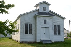 | Bigelow Methodist Episcopal Church, South | building | 1996 | 96000353 |
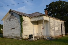 | Bigelow Rosenwald School | building | 2004 | 04000491 |
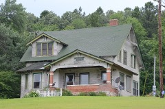 | Camp House | building | 2013 | 13000787 |
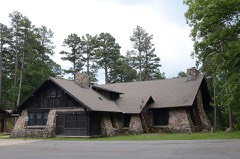 | Camp Ouachita Girl Scout Camp Historic District | district | 1992 | 90001826 |
 | Fourche LaFave River Bridge | structure | 1995 | 95000643 |
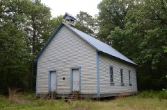 | Hawks Schoolhouse | building | 2002 | 01001528 |
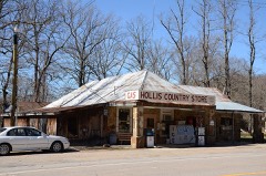 | Hollis Country Store | building | 2002 | 02001598 |
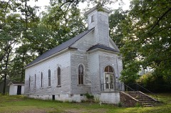 | Houston Methodist Episcopal Church, South | building | 1994 | 94000494 |
 | Perry County Courthouse | building | 1976 | 76000443 |
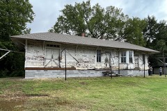 | Perry Rock Island Railroad Depot | building | 2021 | 100006027 |
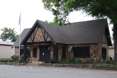 | Perryville American Legion Building | building | 1990 | 90001377 |
 | Perryville Commercial Historic District | district | 2012 | 11001048 |
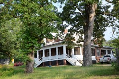 | C.L. Sailor House | building | 1998 | 98000880 |
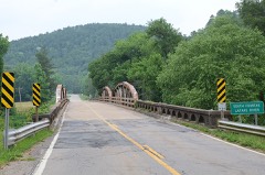 | South Fourche LaFave River Bridge | structure | 2004 | 04001044 |
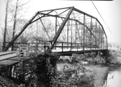 | Wallace Bridge | structure | 2008 | 08000724 |
Every wildfire the federal occurrence database records inside this county: 564 of them, burning about 10,684 acres. 73 started naturally and 122 were recorded as arson. Each settlement page carries the fires within five miles of it.
| Reported cause | Fires |
|---|---|
| Debris and open burning | 145 |
| Missing data/not specified/undetermined | 142 |
| Arson/incendiarism | 122 |
| Natural | 73 |
| Equipment and vehicle use | 41 |
| Railroad operations and maintenance | 13 |
| Recreation and ceremony | 11 |
| Misuse of fire by a minor | 6 |
| Smoking | 5 |
| Fireworks | 4 |
| Power generation/transmission/distribution | 2 |
The five largest, by the area the report gives. Two of them were set deliberately.
| Date | Cause | Size | Reported by | Name on the report |
|---|---|---|---|---|
| 21 November 2017 | Arson/incendiarism | 954 acres | Ouachita National Forest | FORKED |
| 13 August 2012 | Natural | 825 acres | Arkansas Forestry Commission | CASA |
| 21 September 2010 | Debris and open burning | 705 acres | Arkansas Forestry Commission | NIMROD |
| 3 May 2014 | Natural | 695 acres | Ouachita National Forest | MIDNIGHT |
| 24 November 2012 | Natural | 413 acres | Ouachita National Forest | ROUND MTN |
| 27 February 2006 | Arson/incendiarism | 400 acres | Arkansas Forestry Commission | not named |
| 3 June 2012 | Recreation and ceremony | 352 acres | Ouachita National Forest | LITTLE COVE LAKE |
| 30 August 2011 | Natural | 332 acres | Ouachita National Forest | LITTLE BEAR |
Every settlement page carries the fires within five miles of it - see the settlement index below.
The NOAA Storm Events Database holds 412 reports for this county, causing 1 death, no injuries and about $9,118,000 in recorded property damage. Each settlement page carries the reports that name it.
| Kind of event | Reports |
|---|---|
| Thunderstorm Wind | 165 |
| Hail | 103 |
| Flood | 85 |
| Flash Flood | 31 |
| Tornado | 19 |
| Heavy Rain | 9 |
The most serious of them, by death, then injury, then recorded damage. The accounts are quoted exactly as the forecast office filed them.
| When | Event | Place named | Harm | What the report says |
|---|---|---|---|---|
| April 2011 | Flash Flood | Casa | 1 killed, $10,000 | The driver of a feed truck exited his vehicle at a low-water crossing to remove a large log that was in the road at Casa-Aplin Rd. and Deer Run Ln. While he was outside his truck, he was swept away by high water. The incident occurred around 8:00 PM CDT on the 25th, but the accident was not discovered until around 8:00 AM CDT on the 26th. |
| November 2005 | Tornado (F3) | Thornburg | $4,000,000 | A strong tornado touched down over southern Perry County. Winds were estimated at 160 mph. The tornado initially tracked through the Ouachita National Forest where hundreds of trees were either snapped off or blown down. Once emerging from the forest area, the tornado downed eleven large steel towers on a 500 kilovolt power line. As the tornado continued tracking to the northeast, a sawmill was destroyed, along with several houses. Several dozen other houses sustained damage and several mobile homes were overturned. Numerous vehicles were damaged or destroyed, as well as a number of barns and outbuildings. Several chicken houses also sustained damage. Numerous trees and power lines were also downed. The tornado eventually moved into Conway County. |
| May 2011 | Flood | Houston | $1,000,000 | Part of Arkansas Highway 216 was closed due to flooding. |
| April 2011 | Tornado (EF1) | Thornburg | $700,000 | The worst damage from this tornado occurred at Heifer International's ranch. Several buildings had their roofs torn off and thrown into adjacent fields and several hay barns were destroyed. No animals at the ranch were harmed. Otherwise, several houses had major roof damage and some other houses had lesser amounts of roof damage. Dozens of trees were snapped off or blown over. Several vehicles were badly damaged by falling trees. Barns and outbuildings were damaged. A number of power lines were blown down. |
| March 2008 | Flood | Perryville | $600,000 | Heavy rain caused the Fourche LaFave River near Houston to go above moderate flood level and crest at the 7th highest crest of record. Agricultural losses in winter wheat, sod, and livestock were noted. County roads were damaged and Arkansas Highway 300 had water over it for a prolonged period of time. |
| April 2011 | Flood | Houston | $300,000 | Widespread areal flooding occurred. Part of Arkansas Highway 216 was closed from the afternoon of the 27th through the end of the month. |
| May 2010 | Hail | Thornburg | $250,000 | Hail up to 2 inches in diameter broke windows, dented and tore siding, damaged roofs, broke windshields, and ruined gardens in the Union Valley community. |
| April 2008 | Flood | Nogal | $250,000 | Minor flooding at the Toad Suck Lock and Dam on the Arkansas River occurred for two days. In Perry County, damages were noted to agricultural, county roads, two to four homes, and at least one business. Crests were slightly higher than in March. |
| November 1955 | Tornado (F2) | not stated | $250,000 | no account filed |
| June 2008 | Thunderstorm Wind | Casa | $150,000 | Trees were down on power lines, houses and roadways. |
| September 2008 | Flood | Copperas Gap | $110,000 | Water was over the roads all over the county. |
| July 2018 | Thunderstorm Wind | Houston | $100,000 | Trees and power lines were blown down in Houston, and countywide as well. In the city of Houston, a well built tractor shed was destroyed and a garage had its top blown off by powerful thunderstorm winds of 80 to 90 mph. Winds of 60 to 70 mph damaged trees and power lines across the county, and Houston appeared to be the area hardest hit. A horse was killed by a lightning strike in the city of Houston as well. |
| July 2014 | Thunderstorm Wind | Nogal | $100,000 | Trees and power lines were blown down around Toad Suck and a number of other places in Perry County. |
| May 2010 | Thunderstorm Wind | Thornburg | $100,000 | Many trees were blown down in the Thornburg Mountain area and five homes suffered minor damage at Big Rock Estates. |
| August 2011 | Thunderstorm Wind | Adona | $75,000 | Numerous trees were blown down in the area around Wade's Crossing, Thein Rd., Magnolia Rd., Blossom Dr., and Smith's Crossing Rd. |
| June 2009 | Thunderstorm Wind | Perryville | $75,000 | Trees and power lines were blown down, and some roof damage occurred. |
| April 2008 | Flash Flood | Perryville | $75,000 | Mobile homes on Reynolds Street in Perryville were flooded. |
| June 2014 | Thunderstorm Wind | New Dixie | $50,000 | Power lines were blown down, blocking Arkansas 60. Numerous trees were blown down throughout Perry County. |
| September 2009 | Flash Flood | New Dixie | $50,000 | Numerous county roads were flooded. |
| April 2008 | Flood | Fourche | $50,000 | Record levels on Nimrod Lake with resultant excessive spillway releases, when combined with heavy rainfall in the first week of April, produced moderate flooding on the Fourche LaFave River in Perry County. Arkansas Highway 300 and county road flooding were the principal damages during the event. |
| April 1993 | Hail | Nimrod | $50,000 | Hail up to golfball-size damaged a number of roofs. |
| April 1993 | Hail | Aplin | $50,000 | Several roofs and a camper were damaged by golfball-size hail. |
| August 2011 | Thunderstorm Wind | Adona | $30,000 | Trees were blown down, the roof of a house was damaged, and the roof of a chicken house was damaged. |
| October 2014 | Thunderstorm Wind | Perryville | $25,000 | Trees were blown down. One of the trees fell on a house. |
| August 2012 | Thunderstorm Wind | Adona | $25,000 | Two chicken houses were damaged at Wades Crossing. |
| May 2010 | Thunderstorm Wind | Wye | $25,000 | Trees were blown down. |
| December 2009 | Flood | New Dixie | $25,000 | Heavy rainfall on the 23rd and 24th caused the Fourche LaFave River near Houston to rise above flood stage on the afternoon on the 24th. The river remained above flood stage for several days before falling below flood stage during the morning of the 28th. |
| April 2009 | Thunderstorm Wind | Perry | $25,000 | Trees were down across the area. |
| June 2009 | Thunderstorm Wind | Perryville | $25,000 | A tree was down on a house trailer in Harris Brake. |
| October 2009 | Flash Flood | Nogal | $25,000 | Flash flooding caused considerable damage to county roads. |
| April 2011 | Flood | Nogal | $25,000 | no account filed |
| September 1980 | Tornado (F2) | not stated | $25,000 | no account filed |
| September 1977 | Tornado (F1) | not stated | $25,000 | no account filed |
| March 1964 | Tornado (F1) | not stated | $25,000 | no account filed |
| March 1961 | Tornado (F2) | not stated | $25,000 | no account filed |
| May 1955 | Tornado (F2) | not stated | $25,000 | no account filed |
| May 2013 | Thunderstorm Wind | Casa | $20,000 | Trees and power lines were blown down in northern and northwestern parts of Perry County. |
| May 2009 | Flash Flood | Wye | $20,000 | Flooding occurred across the county. |
| September 2008 | Tornado (EF1) | Aplin | $20,000 | This tornado was spawned by Tropical Storm Ike. Trees were blown down. One large tree fell on a mobile home. |
| April 2011 | Flood | Houston | $20,000 | no account filed |
| November 2015 | Thunderstorm Wind | Perryville | $15,000 | The roof of an outdoor stage at the Perry County Fairgrounds was torn off and blown 40 yards away. Also, several large trees were blown down. |
| July 2012 | Thunderstorm Wind | Satuma | $15,000 | Many trees were blown down in the Lake Sylvia Recreation Area. |
| March 2012 | Flood | Houston | $15,000 | Heavy rainfall caused the Fourche LaFave River near Houston to rise above flood stage for several days at the end of March. Portions of Arkansas 216 and Arkansas 300 were flooded. |
| August 2011 | Thunderstorm Wind | Thornburg | $15,000 | Trees were blown down in the Union Valley area. |
| August 2011 | Thunderstorm Wind | Perryville | $15,000 | Trees and power lines were blown down. |
| February 2011 | Tornado (EF1) | Williams Junction | $15,000 | This tornado exited Saline County north-northeast of Reform. Its path in Perry County was in the Ouachita National Forest, where it knocked down trees. The tornado exited Perry County and entered Pulaski County west-southwest of Wye. |
| April 2011 | Thunderstorm Wind | Perryville | $15,000 | Trees were blown down. |
| August 2011 | Thunderstorm Wind | Houston | $15,000 | Trees and power lines were blown down on Arkansas 216. |
| April 2008 | Flash Flood | New Dixie | $12,000 | A local ATV store had two feet of water in it. |
| June 2013 | Flood | Houston | $10,000 | Heavy rainfall during late May caused the Fourche LaFave River near Houston to rise above flood stage during the morning hours on the 2nd. The river remained above flood stage until the morning hours on the 4th, then dropped below flood stage. |
| November 2011 | Flood | Houston | $10,000 | Heavy rainfall caused the Fourche LaFave River near Houston to rise above flood stage during the late morning hours on the 22nd. This river reached over 28 feet before receding below flood stage during the morning hours on the 25th. |
| May 2010 | Thunderstorm Wind | Houston | $10,000 | Power lines were blown down onto a shed, causing the shed to catch fire. |
| May 2011 | Flood | Houston | $10,000 | no account filed |
| June 2012 | Thunderstorm Wind | Houston | $7,000 | A few small trees were blown down, tops were taken out of a few trees, some underpinning was blown out from under two mobile homes, and a couple of small porches had their roofs blown off. |
| March 2016 | Tornado (EF0) | Wye | $5,000 | Mostly tree damage was found, with damage to a roof also. |
| June 2014 | Thunderstorm Wind | Aplin | $5,000 | Trees were blown down. |
| June 2014 | Flood | Houston | $5,000 | Heavy rainfall caused the Fourche LaFave River at Houston to rise above flood stage during the early morning hours of the 10th. This river then fell back below flood stage during the early evening hours of the 11th. |
| April 2013 | Thunderstorm Wind | Thornburg | $5,000 | Trees were blown down on Arkansas 10, blocking the highway. |
| April 2013 | Thunderstorm Wind | Perryville | $5,000 | Trees were blown down at Perryville. |
| April 2013 | Flood | Houston | $5,000 | The Fourche LaFave River near Houston rose above flood stage during the afternoon of the 11th, then remained above flood stage into the 12th. The river then fell below flood stage during the afternoon of the 12th. |
The Survey's mineral resources record lists 26 workings inside this county. 3 still produce and 23 are closed or unrecorded. Each settlement page carries the workings within five miles of it.
| Commodity | Workings |
|---|---|
| Sand and Gravel, Construction | 11 |
| Clay | 5 |
| Stone | 4 |
| Manganese | 4 |
| Stone, Crushed/Broken | 2 |
The least common of them first, because a county's hundredth gravel pit says nothing its first ten did not.
| Where | Site | Commodity | Status | Recorded |
|---|---|---|---|---|
| Copperas Gap Sandstone Quarry | Stone, Crushed/Broken | Past Producer | ||
| Toadsuck Quarry & Mill | Stone, Crushed/Broken | Producer | ||
| A. L. Young | Manganese | Unknown | ||
| Fitch Prospect | Manganese | Prospect | ||
| Harris Prospect | Manganese | Producer | ||
| Unk | Stone | Past Producer | ||
| Unk | Stone | Past Producer | ||
| Unk | Stone | Past Producer | ||
| Unk | Stone | Past Producer | ||
| Vaught Prospect | Manganese | Producer | ||
| Unk | Clay | Past Producer | ||
| Unk | Clay | Past Producer | ||
| Unk | Clay | Past Producer | ||
| Unk | Clay | Past Producer | ||
| Unk | Clay | Past Producer | ||
| Unk | Sand and Gravel, Construction | Past Producer | ||
| Unk | Sand and Gravel, Construction | Past Producer | ||
| Unk | Sand and Gravel, Construction | Past Producer | ||
| Unk | Sand and Gravel, Construction | Past Producer | ||
| Unk | Sand and Gravel, Construction | Past Producer | ||
| Unk | Sand and Gravel, Construction | Past Producer | ||
| Unk | Sand and Gravel, Construction | Past Producer | ||
| Unk | Sand and Gravel, Construction | Past Producer | ||
| Unk | Sand and Gravel, Construction | Past Producer | ||
| Unk | Sand and Gravel, Construction | Past Producer | ||
| Unk Gravel Pits 3 | Sand and Gravel, Construction | Past Producer |
Named settlements recorded in the Geographic Names Information System, each with the topographic sheets covering it. Villages, hamlets and abandoned places alike. Each is shown with the nearest named watercourse or landform and the survey quadrangle it falls on.
Rankin township · 72070 · On Greathouse Creek · Thornburg quadrangle
15 sheets, 1890 to 1985
Rankin township · 72070 · Martindale quadrangle
16 sheets, 1890 to 1985
No longer a settlement
Houston township · 72070 · Near Toms Mountain · Houston quadrangle
17 sheets, 1892 to 1992
Maumelle township · 72126 · On Narrow Creek · Thornburg quadrangle
15 sheets, 1890 to 1985
No longer a settlement
Houston township · 72070 · On White Branch · Houston quadrangle
17 sheets, 1892 to 1992
No longer a settlement
New Tennessee township · 72857 · On Cedar Gap Branch · Nimrod Dam quadrangle
12 sheets, 1890 to 1982
Kenney township · 72016 · On Kenney Mountain · Fourche quadrangle
16 sheets, 1890 to 1985
No longer a settlement
Wye township · 72016 · On Fourche LaFave River · Fourche quadrangle
16 sheets, 1890 to 1985
Houston township · 72070 · On Harris Creek · Houston quadrangle
17 sheets, 1892 to 1992
No longer a settlement
New Tennessee township · 72126 · On Wallace Creek · Nimrod quadrangle
13 sheets, 1890 to 1982
Fourche Lafave township · 72126 · On Cedar Creek · Perryville quadrangle
18 sheets, 1889 to 1992
Kenney township · 72016 · Near Holmes Hollow · Martindale quadrangle
16 sheets, 1890 to 1985
Cherry Hill township · 72126 · On Big Huston Creek · Aplin quadrangle
14 sheets, 1890 to 1985
Rankin township · 72070 · Near Holmes Hollow · Martindale quadrangle
16 sheets, 1890 to 1985
No longer a settlement
Rose Creek township · 72025 · On Little Rose Creek · Adona quadrangle
18 sheets, 1889 to 1992
Fourche Lafave township · 72070 · On Harris Creek · Perryville quadrangle
18 sheets, 1889 to 1992
Maumelle township · 72126 · On Brown Creek · Thornburg quadrangle
15 sheets, 1890 to 1985
The vanished settlements of Perry County: the places named above that are no longer on the map.