 Block
From the record
14 National Register listings published here.
Sources: the National Register database, National Park Service
129 topographic sheets cover 56 settlements here, and 14 properties are on the National Register of Historic Places.
14 National Register listings published here.
Sources: the National Register database, National Park Service
Every property in this county listed on the National Register of Historic Places, with the year it was listed and the federal nomination document.
| Photograph | Property | Type | Listed | Reference |
|---|---|---|---|---|
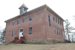 | Bates School | building | 2006 | 06000081 |
 | Cold Spring | structure | 1993 | 93001082 |
| Dooley Dipping Vat | structure | 2006 | 06000466 | |
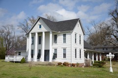 | C.E. Forrester House | building | 1998 | 98001127 |
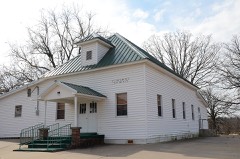 | Mount Pleasant Methodist Church | building | 1986 | 86001207 |
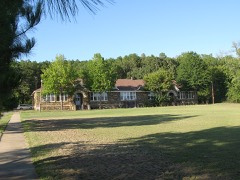 | Parks School | building | 2002 | 02000602 |
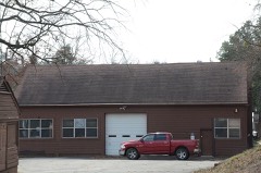 | Poteau Work Center | building | 1993 | 93001094 |
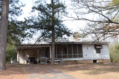 | Poteau Work Center Residence No. 2 | building | 1993 | 93001095 |
| Powder Magazine | structure | 1993 | 93001096 | |
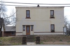 | Scott City County Jail, (Old) | building | 2002 | 02000486 |
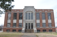 | Scott County Courthouse | building | 1989 | 89001971 |
| Square Rock Dipping Vat | structure | 2006 | 06000464 | |
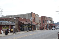 | Waldron Commercial Historic District | district | 2008 | 08000943 |
| Waldron School Historic District | district | 2019 | 100004437 |
Every wildfire the federal occurrence database records inside this county: 608 of them, burning about 9,406 acres. 71 started naturally and 164 were recorded as arson. Each settlement page carries the fires within five miles of it.
| Reported cause | Fires |
|---|---|
| Arson/incendiarism | 164 |
| Debris and open burning | 150 |
| Missing data/not specified/undetermined | 122 |
| Natural | 71 |
| Equipment and vehicle use | 64 |
| Recreation and ceremony | 14 |
| Smoking | 10 |
| Power generation/transmission/distribution | 5 |
| Railroad operations and maintenance | 3 |
| Misuse of fire by a minor | 2 |
| Fireworks | 2 |
| Other causes | 1 |
The five largest, by the area the report gives. Five of them were set deliberately.
| Date | Cause | Size | Reported by | Name on the report |
|---|---|---|---|---|
| 2 February 2018 | Natural | 1,049 acres | Ouachita National Forest | PCS MIDNIGHT FIRE |
| 31 August 2011 | Equipment and vehicle use | 414 acres | Arkansas Forestry Commission | KINGS CREEK |
| 20 December 2004 | Arson/incendiarism | 282 acres | Ouachita National Forest | BLACKBRIER |
| 7 September 2006 | Debris and open burning | 258 acres | Arkansas Forestry Commission | 148 |
| 27 December 2005 | Arson/incendiarism | 234 acres | Arkansas Forestry Commission | not named |
| 7 March 2010 | Arson/incendiarism | 190 acres | Ouachita National Forest | JAMES YOUNG PLACE |
| 30 March 1993 | Arson/incendiarism | 177 acres | Ouachita National Forest | BLACK BRIER |
| 2 April 1995 | Arson/incendiarism | 153 acres | Ouachita National Forest | not named |
Every settlement page carries the fires within five miles of it - see the settlement index below.
The NOAA Storm Events Database holds 346 reports for this county, causing 8 deaths, 3 injuries and about $12,760,000 in recorded property damage. Each settlement page carries the reports that name it.
| Kind of event | Reports |
|---|---|
| Thunderstorm Wind | 146 |
| Hail | 117 |
| Flash Flood | 65 |
| Tornado | 9 |
| Heavy Rain | 6 |
| Funnel Cloud | 2 |
| Flood | 1 |
The most serious of them, by death, then injury, then recorded damage. The accounts are quoted exactly as the forecast office filed them.
| When | Event | Place named | Harm | What the report says |
|---|---|---|---|---|
| May 2013 | Flash Flood | Coaldale | 5 killed, 1 hurt, $9,200,000 | Severe flash flooding occurred across a large part of Scott County. Soon after Midnight CDT on the 31st, two women called 911 after flooding from Mill Creek trapped them in their house at Y City. The Scott County Sheriff and a Wildlife Officer First Class from the Arkansas Game and Fish Commission responded to the call. According to the incident report by the Game and Fish Commission, the rescuers reached the house in an aluminum motorboat, removed one woman from the house and put here in their boat. As they were trying to rescue the second woman, the house collapsed due to the force of the floodwaters. The boat then capsized, drowning the three people in the boat, and the woman in the house also drowned. (The sheriff was a 41 year-old male, the wildlife officer was a 32 year-old male, and the women in the house were females 60 and 65 years old.) It took until June 2nd to recover the bodies of all the victims. Recovery operations were greatly hampered by another round of heavy rain and flooding on the morning of June 1st. Altogether, about 20 people had to be rescued from the flood waters. U.S. 71, the main north-south route through western Arkansas, flooded at Y City. The flooding caused a car to be washed off the highway and a 42 year-old woman in the car drowned. Her husband survived, but had to cling to the bank of a stream for 6 hours before being rescued. Several other cars were washed off roads, as well, but the motorists survived. Arkansas 28 was washed out at Little Cedar Creek (10 miles east of Y City), Big Cedar Creek (12 miles east of Y City), and the Fourche LaFave River (16.5 miles east of Y City). Numerous county roads and bridges were washed out. For the 24-hour period ending at 7 AM on the 31st, Parks measured 7.78 inches of rain and Waldron picked up 5.26 inches. Houses were flooded at a number of places, including Y City, Boles, and Parks. The American Red Cross indicated 7 houses and 15 mobile homes were destroyed, 9 houses and 4 mobile home had major damage, 13 houses and 3 mobile homes had minor damage, and 14 houses and 8 mobile homes were affected. A fiber optic cable was knocked out of service. As a result, there was no landline phone service, cell phone service, or internet service to most of the county for about 24 hours from the 30th into the 31st. |
| April 2010 | Flash Flood | Blue Ball | 1 killed, $20,000 | A 63 year-old man drowned during a flash flood near Union Hill. He tried to drive his pickup truck across a small low-water bridge, but the truck was swept into the creek. Witnesses said the man tried to escape through the driver's window, but he was caught by the current and dragged downstream. |
| March 2023 | Flash Flood | Boles | 1 killed | Numerous roads have been flooded throughout Scott County. However, in Boles there was a report that some people were isolated in their home due to rising flood waters. A man was found drowned the next day when flood waters began to recede, so the timing of death is uncertain. His age is unknown, but he was likely an older adult as he was described as a grandfather. He likely drove into floodwaters and got washed off the road sometime between the night of the 2nd and the morning of the 3rd. |
| May 2002 | Flash Flood | Waldron | 1 killed | A 65 year old female was driving across a low-water crossing when the vehicle was washed off the road. Her two grandchildren were also in the car at the time but were later rescued. She got out of the car and was swept about a half mile downstream and drowned. |
| November 1952 | Tornado (F2) | not stated | 2 hurt, $25,000 | no account filed |
| October 2009 | Flash Flood | Coaldale | $525,000 | Arkansas Highways 28 and 248 were flooded. A number of county roads were damaged by flash flooding. |
| March 2008 | Thunderstorm Wind | Hon | $500,000 | A home was damaged at Hon. Chicken houses and barns were damaged or destroyed. Trees and power lines were down. |
| February 2012 | Thunderstorm Wind | Waldron | $400,000 | A 2-mile wide swath of damage occurred across Waldron. Dozens of trees and power lines were blown down, as were some street lights. Several houses were damaged, primarily due to trees falling on them. Shingles were blown off some roofs and awnings were damaged. Two barns had their roofs blown off. Downtown, some business suffered roof damage and the wall of a concrete block building was blown in. |
| November 2011 | Flash Flood | Coaldale | $400,000 | Several places on U.S. 71 and Arkansas 28 near Waldron flooded. Water was 4 feet deep at the intersection of U.S. 71 and Arkansas 378 at the Elm Park community. U.S. 71 also flooded a couple of miles north of Y City. Numerous county roads were under water. Several homes in Waldron were flooded and a mobile home west of Y City was washed off its foundation. A National Weather Service storm survey indicated virtually every creek had overflowed along Arkansas 28 from the Yell/Scott County line westward to U.S. 71. |
| March 2008 | Flash Flood | Coaldale | $250,000 | Several roads were under water throughout the county. The northbound lane of U.S. Highway 71 at the Scott/Sebastian county line was under water. Minor to major damage was reported to several homes in the Gibson area, and also in the communities of Hon, Cauthron, and Bates. |
| May 2011 | Flood | Coaldale | $250,000 | no account filed |
| May 2010 | Flash Flood | Coaldale | $200,000 | The county judge reported flooding throughout Scott County, with roads and bridges damaged. In Waldron, the cattle auction and a feed store were flooded. |
| January 2007 | Flash Flood | Waldron | $160,000 | Heavy rain caused flash flooding, resulting in damage to county roads and bridges. |
| March 2016 | Tornado (EF1) | Sensation | $150,000 | The tornado uprooted trees and caused damage to several buildings, including 7 to 8 homes. |
| July 2012 | Thunderstorm Wind | Y City | $125,000 | Barns were blown down, roofs were blown off chicken houses and barns, and trees were blown down. |
| May 2015 | Thunderstorm Wind | Mansfield | $100,000 | A chicken house was severely damaged, and parts of a barn were blown onto Highway 80. Several tress and power lines were also damaged. |
| October 2009 | Tornado (EF1) | Cardiff | $100,000 | Thousands of trees were blown down by the tornado, primarily within the Ouachita National Forest. The Knopper's Ford Recreation Area was damaged and had to be closed. Parts of the Sugar Creek Multipurpose Horse and Off-Highway Vehicle Trail also had to be closed. The tornado exited Scott County about 7 1/2 miles north-northwest of Olio and continued into Logan County about 2 1/4 miles south-southeast of Joyland. |
| October 2009 | Flash Flood | Elm Park | $50,000 | A school bus was washed off Tate Road and into a creek. Water came up about 6 feet on the bus. The driver and one student on the bus were rescued and were not injured. |
| February 2009 | Thunderstorm Wind | Waldron | $30,000 | A house on Charcoal Road in Waldron had shingles blown off the roof and covering torn off the carport. Also, sheet metal was torn off the barn. Large pine trees in the area were snapped. |
| November 1960 | Tornado (F1) | not stated | $25,000 | no account filed |
| July 2019 | Thunderstorm Wind | Waldron | $20,000 | Numerous trees were blown down, and the roof was blown off of a house. |
| June 2013 | Flash Flood | Coaldale | $15,000 | Numerous county roads were flooded. A car with four people inside was swept off a low-water crossing and washed into a creek. The people were able to get to high ground and were eventually rescued. A trained spotter 8 miles southeast of Waldron measured 2.50 inches of rain between 7:20 and 9:20 AM CDT on the 1st. Three-day rainfall totals for May 30th through June 1st included 10.29 inches at Parks and 7.92 inches at Waldron. |
| July 2012 | Thunderstorm Wind | Green Ridge | $15,000 | Several outbuildings and a barn were damaged near the Tate community. |
| March 2012 | Flash Flood | Puryear | $15,000 | The Fourche LaFave River flooded the Dooley Rd. Bridge and many county roads in the southern half of Scott County were flooded. |
| May 2020 | Flash Flood | Waldron | $10,000 | Several houses had water in them and several roads had water over them in Waldron. |
| May 2015 | Thunderstorm Wind | Parks | $10,000 | A large barn was damaged and shifted off it's foundation, along with numerous trees uprooted across the Parks area in Scott County. |
| July 2012 | Thunderstorm Wind | Waldron | $10,000 | Trees were blown down onto power lines. |
| July 2012 | Thunderstorm Wind | Waldron | $10,000 | Trees and power lines were blown down. |
| July 2012 | Thunderstorm Wind | Beauchamp | $10,000 | Trees and power lines were blown down. |
| July 2012 | Thunderstorm Wind | Winfield | $10,000 | Trees and power lines were blown down. |
| June 2011 | Flash Flood | Brawley | $10,000 | Numerous roadways were under water and low-water crossings were flooded in the Lake Hinkle area. Jones Creek Rd. was mostly under water. |
| April 2010 | Hail | Brawley | $10,000 | Golf ball size hail fell in the Lake Hinkle area. |
| February 2019 | Thunderstorm Wind | Parks | $5,000 | There was damage to an outbuilding, with aluminum scattered through nearby oak trees. |
| May 2015 | Flash Flood | Coaldale | $5,000 | Highway 28 was flooded, with a car submerged and the driver stranded. |
| April 2014 | Thunderstorm Wind | Cauthron | $5,000 | Phone lines were blown down. |
| May 2014 | Flash Flood | Nella | $5,000 | U.S. 71 was flooded and impassable in southern Scott County. |
| September 2013 | Thunderstorm Wind | Needmore | $5,000 | Trees were blown down on Arkansas 28. |
| August 2013 | Flash Flood | Brawley | $5,000 | Water was over some roads. |
| September 2013 | Thunderstorm Wind | Blue Ball | $5,000 | Large trees were blown down. |
| August 2013 | Thunderstorm Wind | Waldron | $5,000 | A few trees were blown down along Arkansas 250. |
| January 2013 | Flash Flood | Boles | $5,000 | Flash flooding occurred between Y City and Boles. |
| December 2012 | Thunderstorm Wind | Green Ridge | $5,000 | Trees were blown down on Arkansas 80. |
| December 2012 | Thunderstorm Wind | Y City | $5,000 | Trees were blown down. |
| July 2012 | Thunderstorm Wind | Harvey | $5,000 | Several trees were blown down around Harvey. Power outages occurred around Harvey and Nola. |
| September 2012 | Thunderstorm Wind | Parks | $5,000 | Trees were blown down. |
| May 2010 | Flash Flood | Evening Shade | $5,000 | City streets were flooded in Waldron. Parts of Arkansas Highway 80 were flooded as well. |
| October 2009 | Thunderstorm Wind | Y City | $5,000 | Trees were down. |
| April 2009 | Flash Flood | Waldron Muni Arpt | $5,000 | Street flooding occurred in the city of Waldron. |
| October 2009 | Thunderstorm Wind | Waldron | $5,000 | Trees were down. |
| April 1994 | Thunderstorm Wind | Waldron | $5,000 | Thunderstorm winds blew down several trees. |
| April 1957 | Tornado (F2) | not stated | $2,500 | no account filed |
| July 1954 | Tornado (F1) | not stated | $2,500 | no account filed |
| April 2011 | Flash Flood | Waldron | $2,000 | Greenridge Rd. was impassable due to high water. |
| June 2010 | Flash Flood | Needmore | $2,000 | Some low water crossings were flooded around Parks. |
| October 2014 | Thunderstorm Wind | Nola | $1,000 | Large limbs were blown down. |
| April 2014 | Thunderstorm Wind | Waldron | $1,000 | Large limbs were blown down. |
| September 2013 | Thunderstorm Wind | Brawley | $1,000 | Large limbs were blown down. |
| August 2010 | Thunderstorm Wind | Harvey | $1,000 | A large tree was blown down. |
| May 2010 | Flash Flood | Waldron | $1,000 | Street flooding occurred in Waldron. |
| July 1994 | Hail | Blue Ball | $500 | Thunderstorm winds knocked down some large tree limbs. |
The Survey's mineral resources record lists 6 workings inside this county. 1 still produces and 5 are closed or unrecorded. Each settlement page carries the workings within five miles of it.
| Commodity | Workings |
|---|---|
| Sand and Gravel, Construction | 4 |
| Clay | 1 |
| Limestone, High Calcium | 1 |
The least common of them first, because a county's hundredth gravel pit says nothing its first ten did not.
Named settlements recorded in the Geographic Names Information System, each with the topographic sheets covering it. Villages, hamlets and abandoned places alike. Each is shown with the nearest named watercourse or landform and the survey quadrangle it falls on.
District 1 · 72927 · On Little Petit Jean Creek · Abbott quadrangle
22 sheets, 1890 to 1987
No longer a settlement
District 2 · 72958 · On Buffalo Creek · Boles quadrangle
31 sheets, 1879 to 1989
No longer a settlement
District 6 · 72926 · On Mill Creek · Y City quadrangle
19 sheets, 1890 to 1989
No longer a settlement
District 5 · 72927 · Near Round Mountain · Waldron quadrangle
31 sheets, 1879 to 1989
No longer a settlement
District 2 · 72926 · On Cedar Creek · Acorn quadrangle
19 sheets, 1890 to 1989
No longer a settlement
District 3 · 72944 · Near Gibson Ridge · Abbott quadrangle
22 sheets, 1890 to 1987
No longer a settlement
District 6 · 72827 · On East Weaver Creek · Little Texas quadrangle
16 sheets, 1890 to 1985
District 6 · 72838 · On Janes Creek · Harvey quadrangle
16 sheets, 1887 to 1985
No longer a settlement
District 2 · 72958 · On Square Rock Creek · Waldron quadrangle
31 sheets, 1879 to 1989
District 3 · 72958 · On Denton Creek · Horseshoe Mountain quadrangle
20 sheets, 1887 to 1989
No longer a settlement
District 2 · 71953 · On Terrapin Creek · Horseshoe Mountain quadrangle
20 sheets, 1887 to 1989
District 6 · 72833 · On Parker Branch · Freedom Mountain quadrangle
16 sheets, 1887 to 1985
The vanished settlements of Scott County: the places named above that are no longer on the map.