BlockBefore
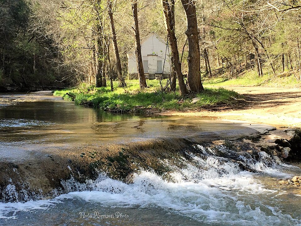
Photograph of Roasting Ear Church and School
Photograph by Nola Gammill Morrison, CC BY-SA 3.0. Via Wikimedia Commons.

Roasting Ear Church and School

Listed on the National Register of Historic Places in 1985.

From the record

“The Roasting Ear Church and School is a historic multifunction building in rural northwestern Stone County, Arkansas. It is located northeast of Onia, on County Road 48 west of its junction with County Road 86.”

Wikipedia article Roasting Ear Church and School, CC BY-SA 4.0.

One of 58 National Register listings published here for Stone County · listed in 1985 · category: Building.

Sources: the Wikipedia article · the National Register database, National Park Service
The listing

  • What is counted as historic. The nomination lists 1 building as contributing to the listing.
  • Address. NE of Onia, Onia, 72533
  • When was it listed? September 1985
  • Category. building
  • Also known as. Stone County MRA
  • District. District 3
  • National Register reference number. 85002230 - assigned by the National Park Service when the property was listed.

Fires near this property

129 since 1992

Regional context, not property-specific evidence. The federal wildfire occurrence database lists 129 fires within 5 miles of Roasting Ear Church and School between 1992 and 2020, burning about 1,323 acres in total. 3 started naturally. 66 were recorded as arson. Distance is straight-line from the map coordinates, so a fire counted here may appear on a neighbouring settlement's page as well.

Reported cause Fires
Arson/incendiarism66
Missing data/not specified/undetermined27
Debris and open burning14
Recreation and ceremony6
Power generation/transmission/distribution5
Equipment and vehicle use4
Natural3
Smoking2
Fireworks1
Other causes1

The most recent of them, most recent first, with the day each was reported and the service that recorded it.

DateCause SizeReported by Name on the report
30 September 1994Arson/incendiarism3.0 acresOzark-St. Francis National Forestsnot named
29 September 2000Missing data/not specified/undetermined3.0 acresOzark-St. Francis National ForestsFLAT
25 September 2005Missing data/not specified/undetermined3.0 acresOzark-St. Francis National ForestsPHILL
20 September 2000Arson/incendiarism1.0 acresArkansas Forestry Commissionnot named
2 September 2012Equipment and vehicle useunder an acreOzark-St. Francis National ForestsTIE RIDGE
2 September 1994Missing data/not specified/undeterminedunder an acreOzark-St. Francis National Forestsnot named
19 September 2000Arson/incendiarism134 acresArkansas Forestry Commissionnot named
19 September 2000Smoking1.0 acresArkansas Forestry Commissionnot named

Every fire recorded in Stone County

Mines and quarries near this property

5 within 5 miles

Regional context, not property-specific evidence. The federal mineral resources record lists 5 workings within 5 miles of Roasting Ear Church and School: 4 producers, 1 occurrence. 4 still produce. What was taken out: Stone, Copper, Iron, Phosphorus-Phosphates, Tantalum, Zinc, Sand and Gravel, Construction. Distance is straight-line from the map coordinates, so a quarry counted here may appear on a neighbouring settlement's page as well.

Where SiteCommodity StatusRecorded
UnkCopper, Iron, Phosphorus-Phosphates, Tantalum, ZincOccurrence
UnkSand and Gravel, ConstructionProducer
UnkStoneProducer
UnkStoneProducer
UnkStoneProducer

Every working recorded in Stone County

Storms near this property

7 since 1993

Regional context, not property-specific evidence. The National Weather Service names Onia, the town this property stands in, in 7 storm reports between 1993 and 2011: 5 thunderstorm wind, 2 hail. No death or injury is recorded in these reports. Each account below is quoted exactly as the forecast office filed it, from the NOAA Storm Events Database, and each date opens the federal record of that event.

WhenEvent Place namedHarm What the report says
April 2011Thunderstorm WindOnia$75,000Empty chicken houses were damaged. A barn roof was blown off. Roads were blocked by fallen trees.
April 2011Thunderstorm WindOnia$10,000Trees were blown down.
May 1997Thunderstorm WindOnia-Thunderstorm winds blew over a trailer and caused roof damage to several buildings. A number of trees and power lines were also knocked down.
June 1995Thunderstorm WindOnia-Thunderstorm winds blew down a large tree across a road.
June 2011HailOnia-no account filed
May 2000Thunderstorm WindOnia-no account filed
April 1993HailOnia-no account filed

Every storm recorded in Stone County

Map coverage status

No historic map-sheet match is published for this property yet. That does not mean no map exists. This record needs a coordinate-quality review before it can be joined to a sheet boundary. Browse the county's mapped places while that work is pending.

Listed places nearby

6 within 8 miles

Other National Register properties close enough to walk or drive between, ordered by distance from this one. Both positions come from the same geocoding pass that matched these properties to their map sheets.

Photograph PropertyDistance Listed
Orvall Gammill Barn2.7 miles1985
George Anderson House3.2 miles1985
John Avey Barn3.6 miles1985
Clarence Anderson Barn4.6 miles1985
North Sylamore Creek Bridge5.5 miles2010
Jim Morris Barn5.6 miles1985

Sources for this property

National Archives recordThe nomination case file for reference 85002230 in Record Group 79.
Wikipedia articleCommunity-written account of this property, licensed CC BY-SA.
Stone CountyAll 58 listed properties in this county.

Provenance

  • Listing record. National Park Service National Register of Historic Places, listed-properties dataset, current to 2026-05-22.
  • Map join. Address geocoded through the United States Census geocoder, then tested against the published boundary of every sheet in the USGS Historical Topographic Map Collection.
  • How this page is made. Listing fields come from federal records; map-sheet coverage is a labelled coordinate-to-boundary calculation, not a source-field claim.
  • Wildfire. Short, Karen C. 2022. Spatial wildfire occurrence data for the United States, 1992-2020 [FPA_FOD_20221014]. 6th Edition. Fort Collins, CO: Forest Service Research Data Archive. https://doi.org/10.2737/RDS-2013-0009.6 Collected with United States Government funding and usable without additional permissions or fees.
  • Mines and quarries. USGS Mineral Resources Data System (MRDS) https://mrdata.usgs.gov/mrds/ A work of the United States government, no copyright under 17 U.S.C. 105.
  • Storms. NOAA National Centers for Environmental Information, Storm Events Database https://www.ncei.noaa.gov/stormevents/ A work of the United States government, no copyright under 17 U.S.C. 105. Narratives are quoted verbatim from the National Weather Service report and are not edited or summarised.