 Block
From the record
2 National Register listings published here.
Sources: the National Register database, National Park Service
33 topographic sheets cover 9 settlements here, and 2 properties are on the National Register of Historic Places.
2 National Register listings published here.
Sources: the National Register database, National Park Service
Every property in this county listed on the National Register of Historic Places, with the year it was listed and the federal nomination document.
| Photograph | Property | Type | Listed | Reference |
|---|---|---|---|---|
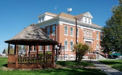 | Cheyenne County Courthouse | building | 1989 | 89000997 |
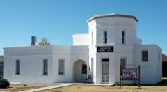 | Cheyenne County Jail | building | 1988 | 88000758 |
Every wildfire the federal occurrence database records inside this county: 153 of them, burning about 20,597 acres. 21 started naturally and 1 was recorded as arson. Each settlement page carries the fires within five miles of it.
| Reported cause | Fires |
|---|---|
| Missing data/not specified/undetermined | 113 |
| Natural | 21 |
| Equipment and vehicle use | 12 |
| Debris and open burning | 3 |
| Smoking | 2 |
| Other causes | 1 |
| Arson/incendiarism | 1 |
The five largest, by the area the report gives. None of them was recorded as arson.
| Date | Cause | Size | Reported by | Name on the report |
|---|---|---|---|---|
| 31 May 2002 | Natural | 15,000 acres | Pueblo Interagency Dispatch Center | CHEYENNE COUNTY |
| 10 October 2003 | Missing data/not specified/undetermined | 2,100 acres | Colorado State Forest Service-State Headquarters | not named |
| 20 July 2005 | Missing data/not specified/undetermined | 800 acres | Colorado State Forest Service-State Headquarters | not named |
| 9 February 2013 | Missing data/not specified/undetermined | 400 acres | West Cheyenne Fire Protection District (Kit Carson Volunteer Fire Department) | UNKNOWN |
| 6 March 2010 | Missing data/not specified/undetermined | 300 acres | Colorado State Forest Service-State Headquarters | not named |
| 29 April 2011 | Missing data/not specified/undetermined | 200 acres | Colorado State Forest Service-State Headquarters | CHEYENNE WELLS |
| 25 August 1995 | Natural | 200 acres | Cheyenne County | not named |
| 17 June 2011 | Missing data/not specified/undetermined | 160 acres | Colorado State Forest Service-State Headquarters | CHEYENNE WELLS |
Every settlement page carries the fires within five miles of it - see the settlement index below.
The NOAA Storm Events Database holds 851 reports for this county, causing no deaths, 7 injuries and about $4,529,220 in recorded property damage. Each settlement page carries the reports that name it.
| Kind of event | Reports |
|---|---|
| Hail | 484 |
| Thunderstorm Wind | 238 |
| Tornado | 94 |
| Flash Flood | 27 |
| Funnel Cloud | 4 |
| Heavy Rain | 2 |
| Flood | 2 |
The most serious of them, by death, then injury, then recorded damage. The accounts are quoted exactly as the forecast office filed them.
| When | Event | Place named | Harm | What the report says |
|---|---|---|---|---|
| July 1958 | Tornado (F2) | not stated | 5 hurt, $25,000 | no account filed |
| May 2016 | Thunderstorm Wind | Kit Carson | 2 hurt, $30,000 | The intense thunderstorm winds blew the roof off the house. Two people in the house were directly injured from the thunderstorm winds. |
| June 1979 | Tornado (F2) | not stated | $2,500,000 | no account filed |
| June 2009 | Hail | Wild Horse | $750,000 | The combination of hail and strong wind broke windows and stripped leaves off of trees. Wind speeds were estimated at 65 mph. |
| August 2025 | Thunderstorm Wind | Wild Horse | $175,000 | Report of roof damage, some windows blown out. Stock tanks and dumpsters tossed up to half a mile away to the southeast. A communications tower folded in half. Tons of dead trees and fences blown over and laying to the southeast as well. |
| August 2017 | Flash Flood | Wild Horse | $150,000 | An official for the railroad that runs by Wild Horse reported portions of track had been washed out along a five mile stretch from roughly CR R to CR 14. There were also public reports of water running over Highway 287/40 between CR R and CR 14. Rainfall estimates close to 2.50 occurred in this area in less than an hour time frame. Total amount of washed out track was not given; best guess is around 400 ft. |
| July 2020 | Thunderstorm Wind | Salis | $100,000 | A delayed report was received via social media of two center pivots blown over due to strong wind estimated at 80 mph. |
| April 2010 | Hail | Kit Carson | $100,000 | Observer reported ten windows were broken in his house, two vehicles completely damaged beyond repair, and hail damage to all buildings. |
| August 2019 | Thunderstorm Wind | Arapahoe | $80,000 | Significant damage and a power outage was originally reported by emergency management in Arapahoe due to thunderstorm wind gusts. Additional damage reports from the public in Arapahoe included the following: a 30 foot by 80 foot Quonset hut was completely destroyed, numerous power lines were downed, multiple houses had their roofs blown off, and a large steel building with a concrete base was destroyed as a result of this thunderstorm wind event. |
| May 2016 | Thunderstorm Wind | Kit Carson | $80,000 | Two to possibly three roofs have collapsed in town and numerous trees have been blown down. Several semis have also been blown over Highway 287 and there are power lines across the highway due to power poles being blown down. |
| August 2017 | Flash Flood | Sorrento | $75,000 | Heavy rainfall fell so fast that the water flowed into a house. The water was so extensive it had to be diverted from the house by county personnel. The water damage was so severe the resident could not live in the house for a month while repairs were being done. |
| May 2007 | Flood | Kit Carson | $75,000 | Eureka Creek railroad bridge, just north of Hwy 40 about 6 miles ENE of Kit Carson, washed out. Water was also reported flowing over Highway 40. Law enforcement also reported flooding of county road 27 (south of U.S. highway 40) in this same area. Road 43 north of Cheyenne Wells was also reported to be covered with water from this same heavy rain event. |
| September 2016 | Tornado (EF0) | Cheyenne Wells | $46,000 | A landspout tornado developed west of Cheyenne Wells between CR 42 and CR 43 just north of Highway 40, slowly moving east. Minor damage was sustained to most houses from South 1st Street to South 2nd Street between West 14th and West 10th. Damage included shingles blown off roofs, a garage door blown inward, a piece of tin ripped off a metal shed, windows broken, and sections of privacy fence blown down. The most notable damage was a six car garage leveled due to the walls collapsing and a mature pine tree being uprooted. The tornado ended at West 10th Street. |
| July 2009 | Thunderstorm Wind | Cheyenne Wells | $35,500 | Eight to ten inch diameter trees were reported down and power outages occurred across the town. A grain auger was damaged. The back window of an SUV was blown in and a pick-up truck was pushed into a ditch. |
| July 2016 | Tornado (EF1) | Salis | $32,500 | An individual from the public reported a tornado five miles south of Arapahoe. Based on the tornadic circulation on radar, the tornado began northeast of the CR N/CR 51 intersection and crossed CR N as it moved south. The tornado caused damage to a farmstead on the east side of CR 51 south of the CR M/CR 51 intersection. Damage included trees being broken off and losing most of the shingles and roofing material off the house on the north side of the roof. The tornado also broke off three electrical poles along CR 51 roughly a quarter mile south of the house. The tornado lifted near the CR L/CR 51 intersection. |
| May 2013 | Thunderstorm Wind | Cheyenne Wells | $30,000 | Severe wind gusts from a thunderstorm caused an estimated 20 trees to be blown down in Cheyenne Wells. |
| June 2020 | Thunderstorm Wind | Salis | $25,000 | Thunderstorm winds tipped over an irrigation pivot. Blowing dust was also observed. A nearby mesonet site measured the peak gust. |
| June 2015 | Thunderstorm Wind | Arapahoe | $25,000 | A center pivot was tipped over from thunderstorm wind gusts. |
| September 2014 | Thunderstorm Wind | Kit Carson | $25,000 | Roof blown off of a house in town. Time estimated by radar. |
| April 2007 | Tornado (EF0) | Wild Horse | $25,000 | Brief tornado on east side of town, or about Roads R, 9. The doors on a quonset hut were damaged, a trailer was pushed over and was leaning against a building. The cross on a church received minor damage. |
| August 2019 | Thunderstorm Wind | Cheyenne Wells | $20,000 | Thunderstorm wind damage was observed in Cheyenne Wells. A family member of an NWS employee lost their farm outbuilding. The Knights of Columbus building lost its roof. Law enforcement officials reported that a metal roof was blown over onto several vehicles in a parking lot. |
| July 2010 | Hail | Firstview | $15,000 | Hail damaged vehicles in the area. |
| May 2010 | Thunderstorm Wind | Carlton | $15,000 | Power lines reported down on highway 40 just west of the state line. A cattle feeder and cattle shed were also damaged. |
| May 2007 | Thunderstorm Wind | Arapahoe | $15,000 | Winds flipped over irrigation pivots. |
| August 2023 | Hail | Aroya | $10,000 | Baseball size hail broke numerous double paned windows in a home in extreme northwest Cheyenne County. A few miles away, quarter to golf ball size hail accumulated to a depth of six inches. |
| July 2020 | Thunderstorm Wind | Firstview | $6,000 | A semi was blown over on Highway 40 at mile marker 463. The time of the event is estimated. |
| July 2014 | Thunderstorm Wind | Arapahoe | $6,000 | Six utility poles were blown down by strong thunderstorm outflow at Hwy 385 and Road G south of Burlington. |
| July 1998 | Thunderstorm Wind | Cheyenne Wells | $6,000 | A possible heat burst from high altitude blew a roof from a shed. |
| June 2017 | Hail | Wild Horse | $5,000 | Quite a bit of golf ball size hail fell. The hail broke windows on the north side of the house. |
| July 2009 | Thunderstorm Wind | Arapahoe | $5,000 | Spotter reported winds estimated at 80 mph. Tree limbs were down in town. Nearby Cheyenne Wells had earlier measured a wind gust of 83 mph. |
| August 2019 | Hail | Cheyenne Wells | $4,000 | Hail ranged from quarter to golf ball size near Cheyenne Wells. Wind-driven hail reported broke several windows in the Cheyenne Wells area. |
| July 2019 | Hail | Cheyenne Wells | $3,000 | The Cheyenne county dispatch reported broken windows, rain gauges, small tree limbs down due to at least quarter size hail. They also reported larger hail stones but couldn't provide an estimate. |
| July 1998 | Thunderstorm Wind | Kit Carson | $3,000 | A possible heat burst from high altitude blew a roof from a shed. |
| July 2022 | Hail | Sorrento | $2,500 | Report received via social media of wind driven hail damage to vinyl siding on a house. Estimated the hail size based on the picture of holes in the siding. |
| July 2020 | Flash Flood | Cheyenne Wells | $2,500 | Local law enforcement and a trained storm spotter provided several reports of several inches of water flowing across Hwy 385 at mile marker 147 south of Cheyenne Wells. |
| July 2011 | Flash Flood | Wild Horse | $2,500 | Cheyenne county dispatch reports that County Road 8 is washed out both north and south of Wild Horse. Another report included water over the intersection of Road 8 and Highway 287. In addition, a co-op observer north of Wild Horse reported 2.64 inches of rain as of 709 pm MDT. |
| July 2010 | Hail | Firstview | $2,500 | Hail resulted in damage to corn and wheat crops. All windows on north-facing side of buildings are broken. Time estimated from Doppler radar. |
| May 2020 | Thunderstorm Wind | Arapahoe | $2,000 | Thunderstorm wind gust of 74 MPH via a Davis Instrument. At the location, branches of unknown size were broken off trees and fascia was torn off a house. |
| July 2019 | Thunderstorm Wind | Cheyenne Wells | $2,000 | The Cheyenne County Sheriff's Office Facebook page reported multiple power lines down and water over roadways. Radar estimated the time of the event. |
| July 2010 | Thunderstorm Wind | Firstview | $2,000 | A couple of power poles were blown down, as well as several live three-inch diameter tree branches. Some shingles were also damaged. |
| May 1999 | Thunderstorm Wind | Arapahoe | $2,000 | Strong winds broke 6 inch tree limbs and destroyed several farm buildings. |
| August 2025 | Flash Flood | Aroya | $1,000 | Basement of residence was flooded. Storm total was 3.5 inches. |
| July 2022 | Thunderstorm Wind | Kit Carson | $1,000 | A tree in Kit Carson was uprooted by thunderstorm wind gusts. The rain soaked soil may have helped the tree be blown over. |
| September 2021 | Thunderstorm Wind | Wild Horse | $1,000 | As a line of thunderstorms moved across Cheyenne County, strong wind gusts up to 60 mph scattered construction barrels and signs across Highway 287. |
| July 2018 | Hail | Kit Carson | $1,000 | At least one vehicle window was broken by the hail. |
| August 2017 | Thunderstorm Wind | Wild Horse | $1,000 | Two limbs of unknown size were broken off trees and a 60 year old dead tree was blown over. |
| June 2011 | Thunderstorm Wind | Wild Horse | $1,000 | Five to nine inch diameter limbs torn from trees. A ten foot long empty stock tank was blown 1/8 mile. A ten foot long metal feeder was damaged and blown 1/16 mile. Time of report estimated from radar and nearby storm reports. |
| June 2011 | Thunderstorm Wind | Kit Carson | $1,000 | A power pole was snapped off at the base. |
| June 2009 | Thunderstorm Wind | Cheyenne Wells | $1,000 | Signs and 3 diameter tree branches were blown down by thunderstorm winds. |
| April 2007 | Tornado (EF1) | Cheyenne Wells | $1,000 | A single power pole was broken at Roads Z, 43. Otherwise the tornado was over open fields with no known damage. Tornado developed near Roads X, 46 and dissipated near Roads AA, 42. |
| March 1998 | Thunderstorm Wind | Arapahoe | $1,000 | Estimated 60-80 mph thunderstorm wind gust blew small kitchen cabinet 30 feet into tree. Lifted children's wagon about 4 feet off ground. Garage window blown out. Empty 55 gallen drums rolled. |
| July 1995 | Hail | Arapahoe | $1,000 | Also 80 mph winds with power poles down. |
| July 2019 | Thunderstorm Wind | Carlton | $800 | Tree limbs up to three inches in diameter were blown down. |
| October 2017 | Thunderstorm Wind | Cheyenne Wells | $500 | Three to four inch diameter tree limbs were blown down. |
| May 2013 | Hail | Kit Carson | $500 | no account filed |
| June 2006 | Hail | Cheyenne Wells | $250 | Hail broke window in garage. |
| March 1980 | Tornado (F1) | not stated | $250 | no account filed |
| June 1979 | Tornado (F1) | not stated | $250 | no account filed |
| June 1957 | Tornado (F1) | not stated | $250 | no account filed |
| June 2013 | Thunderstorm Wind | Kit Carson | $200 | Three inch diameter green tree limb blown down due to severe winds. Visibility also dropped to near zero at times due to blowing dust. Estimated wind gust based on radar. |
The Survey's mineral resources record lists 7 workings inside this county. None of them still produces: all are closed or unrecorded. Each settlement page carries the workings within five miles of it.
| Commodity | Workings |
|---|---|
| Sand and Gravel, Construction | 5 |
| Uranium | 2 |
The least common of them first, because a county's hundredth gravel pit says nothing its first ten did not.
| Where | Site | Commodity | Status | Recorded |
|---|---|---|---|---|
| Unknown | Uranium | Past Producer | ||
| Unnamed Uranium Occurrence | Uranium | Occurrence | ||
| Unknown | Sand and Gravel, Construction | Occurrence | Gravel, Sand | |
| Unknown | Sand and Gravel, Construction | Occurrence | Sand | |
| Unknown | Sand and Gravel, Construction | Past Producer | ||
| Unknown | Sand and Gravel, Construction | Past Producer | ||
| Unknown | Sand and Gravel, Construction | Past Producer |
Named settlements recorded in the Geographic Names Information System, each with the topographic sheets covering it. Villages, hamlets and abandoned places alike. Each is shown with the nearest named watercourse or landform and the survey quadrangle it falls on.
Kit Carson census division · 80862 · In Aroya Gulch · Aroya quadrangle
12 sheets, 1891 to 1984
Cheyenne Wells census division · 80810 · Cheyenne Wells quadrangle
14 sheets, 1892 to 1982
Kit Carson census division · 80825 · On Middle Fork Big Spring Creek · Big Spring quadrangle
13 sheets, 1891 to 1982
Kit Carson census division · 80825 · On Wild Horse Creek · Kit Carson quadrangle
13 sheets, 1891 to 1982
Cheyenne Wells census division · 80810 · Cheyenne Wells NE quadrangle
14 sheets, 1892 to 1982