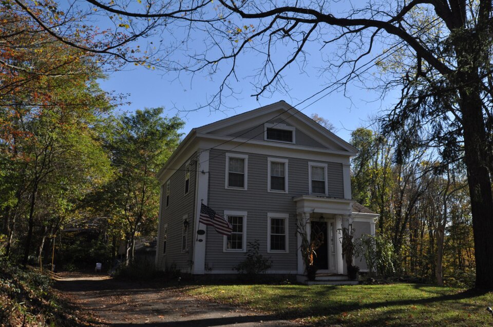
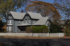
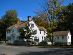
Built in 1838 (Greek Revival architecture). Listed on the National Register of Historic Places in 2000.
From the record
“Andrew Castle House, also known as the Castle-Russell House, is a historic house at 555 Amity Road in Woodbridge, Connecticut. Built in 1838, it is a locally distinguished example of high-style Greek Revival architecture, and is notable as the home of three prominent local physicians.”
Wikipedia article Dr. Andrew Castle House, CC BY-SA 4.0.
One of 272 National Register listings published here for New Haven County · listed in 2000 · category: Building · built in 1838, Greek Revival architecture.
National Register reference number.00000299- the number the National Park Service assigned this property when it was listed, and the key its nomination file is catalogued under at the National Archives.
THE town of Woodbridge lies northwest of New Haven, having New Haven and Orange for its southern boundary, Derby, Ansonia and Seymour on the west, Bethany on the north, and the West Rock range of hills on the east. It was incorporated in 1784. The scenery of Woodbridge is picturesque and attractive. From numerous points may be seen the city of New Haven, the mouth of its harbor and Long Island sound, with its white sails or its palatial steamers, as they pass to their destined ports. From some of its elevations may be seen more than fifty miles of Long Island sound, and of the north shore of Long Island. Round Top and its companion, Tomlinson hill, are each of them over 600 feet high, and from their tops may be seen with a glass, in addition to the extensive view of the sound and Long Island, some 15 of the towns which surround them. The late President Woolsey, of Yale College, when taking the view from these hills, remarked: " We have no view in the vicinity of New Haven to equal this."
Woodbridge is celebrated for its healthy atmosphere. Beingseven miles from Long Island sound, and having an altitude of from four to six hundred feet above the sea level, it combines the sea and mountain air, making a most delightful and healthful atmosphere. Those who have resided in other localities say that the atmosphere of Woodbridge is as good as at Litchfield in this state, or any place within a hundred miles of New Haven. It is a suggestion of some of the old physicians of New Haven when anything is the matter with the babies, " Take them up to Woodbridge. The Woodbridge air is better than any medicine I can give them." Woodbridge is also celebrated for the excellence of its water, which is noted for its purity and coolness. The necessity of ice is hardly felt, so cool and refreshing is the water from its numerous springs.
Regional context, not property-specific
evidence. The
federal wildfire occurrence database
lists 234 fires within 5 miles of Dr. Andrew Castle House
between 1992 and 2020, burning about 340 acres in total. None started naturally. 40 were recorded as arson.
Distance is straight-line from the map coordinates, so a fire counted
here may appear on a neighbouring settlement's page as well.
Reported cause
Fires
Missing data/not specified/undetermined
145
Arson/incendiarism
40
Debris and open burning
19
Recreation and ceremony
16
Smoking
7
Misuse of fire by a minor
5
Equipment and vehicle use
2
The most recent of
them, most recent first, with the day each was reported and the service
that recorded it.
Regional context, not property-specific
evidence. The federal mineral resources record lists
43 workings within 5 miles of Dr. Andrew Castle House: 28 past producers, 13 producers, 1 occurrence, 1 unknown.
13 still produce. What was taken out: Sand and Gravel, Construction, Stone, Crushed/Broken, Stone, Dimension, Stone. Distance is straight-line from the
map coordinates, so a quarry counted here may appear on a neighbouring
settlement's page as well.
Regional context, not property-specific
evidence. The National Weather Service names
Woodbridge, the town this property stands in, in 10 storm reports between 1999 and 2024: 6 flash flood, 3 thunderstorm wind, 1 lightning.
No death or injury is recorded in these reports. Each account below is quoted exactly as the forecast office
filed it, from the NOAA Storm Events Database, and each date
opens the federal record of that event.
Numerous roads were closed due to flooding in the towns of New Haven and West Haven. A school bus loaded with children became stuck in high water at the intersection of Washington Ave. and Wood St. in West Haven. The water was so high that the children had to stand on the seats to avoid getting wet. The local fire department rescued the children on board. The basement of Seth Haley School on South St. in West Haven filled with two to three feet of water in approximately ten minutes and caused the school to be closed for the day. Rainfall totals ranged from 1.73 inches at New Haven/Tweed Airport to 3.05 inches in Hamden.
No historic map-sheet match is published
for this property yet. That does not mean no map exists. This record needs
a coordinate-quality review before it can be joined to a sheet boundary.
Browse the county's mapped places while that work is
pending.
Listed places nearby
6 within 8 miles
Other National Register properties close
enough to walk or drive between, ordered by distance from this one. Both
positions come from the same geocoding pass that matched these properties
to their map sheets.
Listing record. National Park Service National Register of Historic Places, listed-properties dataset, current to 2026-05-22.
Map join. Address geocoded through the United States Census geocoder, then tested against the published boundary of every sheet in the USGS Historical Topographic Map Collection.
How this page is made. Listing fields come from federal records; map-sheet coverage is a labelled coordinate-to-boundary calculation, not a source-field claim.
Wildfire. Short, Karen C. 2022. Spatial wildfire occurrence data for the United States, 1992-2020 [FPA_FOD_20221014]. 6th Edition. Fort Collins, CO: Forest Service Research Data Archive. https://doi.org/10.2737/RDS-2013-0009.6 Collected with United States Government funding and usable without additional permissions or fees.
Mines and quarries. USGS Mineral Resources Data System (MRDS) https://mrdata.usgs.gov/mrds/ A work of the United States government, no copyright under 17 U.S.C. 105.
Storms. NOAA National Centers for Environmental Information, Storm Events Database https://www.ncei.noaa.gov/stormevents/ A work of the United States government, no copyright under 17 U.S.C. 105. Narratives are quoted verbatim from the National Weather Service report and are not edited or summarised.
 Block