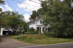
Listed on the National Register of Historic Places in 1977.
From the record
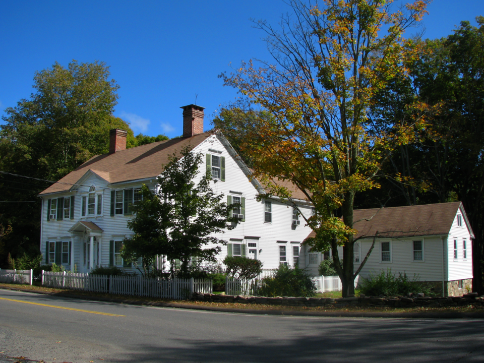
“The Wheeler-Beecher House is a historic house at 562 Amity Road Connecticut Route 63 in Bethany, Connecticut. Built in 1807, it is a good example of Federal period architecture, designed by New Haven architect David Hoadley.”
Wikipedia article Wheeler-Beecher House, CC BY-SA 4.0.
One of 272 National Register listings published here for New Haven County · listed in 1977 · category: Building.
National Register reference number.77001400- the number the National Park Service assigned this property when it was listed, and the key its nomination file is catalogued under at the National Archives.
Bethany is one of the few towns which has no railroad within its bounds, but for 50 years the Watertown or Straits turnpike afforded comparatively easy communication. It is still one of the main highways in the northern and eastern parts, but for many years has been under the care of the town.
The territory in Bethany was included in the purchases made from the Indians in behalf of the towns of New Haven and Milford. The early settlements, also, are a part of the history of these towns and of Woodbridge and are not here reproduced. Some of the principal families, in the different parts of the town, were: the Hotchkiss, Peck and Hitchcock, in the interior and southwest; the French and Lounsbnry, in the west; the Bradley, Beard and Perkins, in the north; the Tuttle, Beecher and Tolles, in the east; the Clark, Sperry and Hitchcock, in the south. The population of the town has steadily declined, as will be seen from the official tables.
Regional context, not property-specific
evidence. The
federal wildfire occurrence database
lists 537 fires within 5 miles of Wheeler-Beecher House
between 1992 and 2020, burning about 1,360 acres in total. None started naturally. 157 were recorded as arson.
Distance is straight-line from the map coordinates, so a fire counted
here may appear on a neighbouring settlement's page as well.
Reported cause
Fires
Missing data/not specified/undetermined
208
Arson/incendiarism
157
Recreation and ceremony
60
Misuse of fire by a minor
46
Debris and open burning
37
Smoking
14
Railroad operations and maintenance
8
Equipment and vehicle use
7
The most recent of
them, most recent first, with the day each was reported and the service
that recorded it.
Regional context, not property-specific
evidence. The federal mineral resources record lists
31 workings within 5 miles of Wheeler-Beecher House: 17 past producers, 9 producers, 4 occurrences, 1 unknown.
9 still produce. What was taken out: Sand and Gravel, Construction, Copper, Stone, Dimension, Limestone, General. Distance is straight-line from the
map coordinates, so a quarry counted here may appear on a neighbouring
settlement's page as well.
Regional context, not property-specific
evidence. The National Weather Service names
Bethany, the town this property stands in, in 9 storm reports between 1996 and 2020: 5 thunderstorm wind, 1 lightning, 1 flash flood, 1 hail.
The reports record 1 injury. Each account below is quoted exactly as the forecast office
filed it, from the NOAA Storm Events Database, and each date
opens the federal record of that event.
EF1 Tornado staring in Bethany, CT and ending in North Haven, CT. Maximum path width of 500 yards and a path length of 11.1 miles.||Based on a National Weather Service damage survey done in |conjunction with CT Division of Emergency Management and Homeland |Security and local CT town emergency managements, it has been |determined that a strong EF1 tornado, with maximum wind speed of |110 mph, tracked southeast from Bethany to North Haven CT. ||The tornado first touched down in a forested area to the |southeast of Judd Hill Rd in Bethany CT. The tornado tracked |southeast over primarily forested areas from Amity Rd, to Munson |Rd towards Litchfield Tpke, creating a path of damage about 75 |yards wide, with hardwood tree damage consistent with wind speeds |of 80 to 90 mph. ||The path of damage widened to around 300 yards as the tornado |tracked southeast towards Lake Bethany. Structural damage, |including significant roof damage to several homes, and snapped |hardwood trees indicated wind speeds of around 100 mph in this |area.||The tornado path continued southeast for another 4 miles to near |the town center of Hamden CT, with tree and structural damage |indicative of wind speeds of 70 to 80 mph. The intensity picked up|significantly as the tornado approached the center of Hamden, as |evidenced by extensive damage to numerous buildings, including the|flat roof of a 2 story building across from Hamden Town Hall |being torn apart. Wind speeds are estimated to be around 100 mph |based on the damage to these buildings, bent metal fencing around|town hall, and uprooted and snapped trees.||The tornado reached maximum strength and width from this point on|as it continued southeast across Wilbur Cross Parkway, Interstate|91, and down to the intersection of Arrowdale and Thompson St in |North Haven, CT. Tremendous hardwood tree damage and structural |damage was indicative of wind speeds of 110 mph and an expanded |width of 500 yards. It is a this point that the tornado appears to|have dissipated with its destructive straight line winds fanning |out to the coast.
As a thunderstorm moved across Long Island Sound, it developed into a severe thunderstorm. This storm then produced damaging winds that knocked down a tree on Payne Road. This incident was reported by the local Police Department.
No historic map-sheet match is published
for this property yet. That does not mean no map exists. This record needs
a coordinate-quality review before it can be joined to a sheet boundary.
Browse the county's mapped places while that work is
pending.
Listed places nearby
6 within 8 miles
Other National Register properties close
enough to walk or drive between, ordered by distance from this one. Both
positions come from the same geocoding pass that matched these properties
to their map sheets.
Listing record. National Park Service National Register of Historic Places, listed-properties dataset, current to 2026-05-22.
Map join. Address geocoded through the United States Census geocoder, then tested against the published boundary of every sheet in the USGS Historical Topographic Map Collection.
How this page is made. Listing fields come from federal records; map-sheet coverage is a labelled coordinate-to-boundary calculation, not a source-field claim.
Wildfire. Short, Karen C. 2022. Spatial wildfire occurrence data for the United States, 1992-2020 [FPA_FOD_20221014]. 6th Edition. Fort Collins, CO: Forest Service Research Data Archive. https://doi.org/10.2737/RDS-2013-0009.6 Collected with United States Government funding and usable without additional permissions or fees.
Mines and quarries. USGS Mineral Resources Data System (MRDS) https://mrdata.usgs.gov/mrds/ A work of the United States government, no copyright under 17 U.S.C. 105.
Storms. NOAA National Centers for Environmental Information, Storm Events Database https://www.ncei.noaa.gov/stormevents/ A work of the United States government, no copyright under 17 U.S.C. 105. Narratives are quoted verbatim from the National Weather Service report and are not edited or summarised.
 Block