BlockBefore
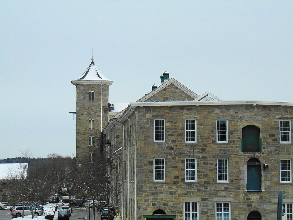
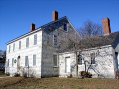
Photograph of Jillson Mills
Photograph by JJBers, CC BY 4.0. Via Wikimedia Commons.

American Thread Company

Listed on the National Register of Historic Places in 2014.

From the record

“Windham Congregational Church, the large cot being the special gift of the children of the Sunday school. Other individual benefactors made cash donations as follows: Rt.”

A Modern History of Windham County, Connecticut : a Windham County Treasure Book (1920). Machine-read text.

One of 82 National Register listings published here for Windham County · listed in 2014 · category: District.

Sources: the county history on the Internet Archive · the National Register database, National Park Service · the Wikipedia article
The listing

The ground it stands on

50,220 words

The chapter on Windham Town in History of Windham County, Connecticut .., published 1889 names Willimantic. This is what it says, exactly as the scans read.

THE town of Windham, one of the smallest in geographical size, but the largest in population, wealth and business importance, occupies the extreme southwest corner of Windham county. Its area is about two and three-fourths square miles. The beautiful valley of the Willimantic river extends along the southern part, entering at the extreme western point and leaving at the southeastern corner. This river affords abundant water power for many factories, and to this circumstance is due the building up and prosperity of the town. The Natchaug, a considerable stream, joins it a short distance east of the borough limits of Willimantic. Back from the river the town is broken into successive ridges of hills, rising about two hundred feet above the general level of the intervening valleys. Besides the borough of Willimantic, in the southwest part, the smaller villages of North Windham in the northern part, South Windham in the southern part and Windham in the central part, are in this town. Otherwise the surface of the town is mostly covered with forest growth which affords some valuable timber. The agricultural interests of the town are not prominent. The New York & New England railroad extends through the western and northern parts and the Providence Division and the

Passage source: History of Windham County, Connecticut .., published 1889.

During that summer (1693) it was determined that the dividing line between the settlers in the wilderness from Hartford and from Norwich should be the Willimantic river^ the Norwich people holding on the east of it and the Hartford people holding on the west of it. In December the town passed regulations in regard to fences, cattle, swine, timber and the warning of town meetings. In the following spring we have the first record of the lay-out of a highway. This was ordered through Peter Grosse's division, extending from the Ponde-place to the Willimantic river near the falls. The meadows in this vicinity fur- nished the Windham settlers with a great part of their hay, and to facilitate its conveyance this highway was ordered " four rods wide from the hill to the river, seven rods wide down to the meadow and four rods wide between meadow and fence." Twelve acres below the falls were allowed to Mr. Crosse in compensation for land taken up by this highway.

Passage source: History of Windham County, Connecticut .., published 1889.

Machine-read from a century-old scan, so expect the errors a machine makes: misspelled names, dropped words, stray characters.

Read the whole chapter on Windham Town - 50,220 words on its settlement, mills, schools and churches.

Fires near this property

102 since 1992

Regional context, not property-specific evidence. The federal wildfire occurrence database lists 102 fires within 5 miles of American Thread Company between 1992 and 2020, burning about 229 acres in total. 2 started naturally. 9 were recorded as arson. Distance is straight-line from the map coordinates, so a fire counted here may appear on a neighbouring settlement's page as well.

Reported cause Fires
Missing data/not specified/undetermined45
Misuse of fire by a minor14
Arson/incendiarism9
Recreation and ceremony8
Smoking8
Debris and open burning7
Power generation/transmission/distribution3
Equipment and vehicle use3
Railroad operations and maintenance3
Natural2

The most recent of them, most recent first, with the day each was reported and the service that recorded it.

DateCause SizeReported by Name on the report
8 September 2020Missing data/not specified/undeterminedunder an acreConnecticut Division of Forestry124 CHAPMAN STREET
4 September 2018Recreation and ceremonyunder an acreConnecticut Division of Forestry69 CIRCLE DRIVE
3 September 1995Arson/incendiarism2.0 acresConnecticut Division of Forestrynot named
16 September 2020Recreation and ceremony94 acresConnecticut Division of ForestryAIRLINE TRAIL
7 August 2008Missing data/not specified/undeterminedunder an acreConnecticut Division of Forestrynot named
5 August 2016Recreation and ceremony1.0 acresConnecticut Division of ForestryHAIN MATERIAL CORP, IN THE REAR OF
29 August 1995Arson/incendiarism1.0 acresConnecticut Division of Forestrynot named
10 August 2008Missing data/not specified/undeterminedunder an acreConnecticut Division of Forestrynot named

Every fire recorded in Windham County

Mines and quarries near this property

10 of 42 shown

Regional context, not property-specific evidence. The federal mineral resources record lists 42 workings within 5 miles of American Thread Company: 33 past producers, 8 producers, 1 unknown. 8 still produce. What was taken out: Stone, Stone, Dimension, Sand and Gravel, Construction, Granite. Distance is straight-line from the map coordinates, so a quarry counted here may appear on a neighbouring settlement's page as well.

Where SiteCommodity StatusRecorded
Larrabee QuarryGranitePast Producer
QuarryGranitePast Producer
Columbia Town PitSand and Gravel, ConstructionPast Producer
Hain Sand & GravelSand and Gravel, ConstructionUnknown
Hain Sand and Gravel PitSand and Gravel, ConstructionProducer
Plains Road PitSand and Gravel, ConstructionProducer
South Windham PitSand and Gravel, ConstructionPast ProducerSedimentary
South Windham PitSand and Gravel, ConstructionProducer
Windham Sand and Stone, Inc. PitSand and Gravel, ConstructionPast ProducerSedimentary
Windham Sand and Stone, Inc. PitSand and Gravel, ConstructionProducer

Every working recorded in Windham County

Storms near this property

27 since 1996

Regional context, not property-specific evidence. The National Weather Service names Willimantic, the town this property stands in, in 27 storm reports between 1996 and 2024: 10 thunderstorm wind, 6 flood, 5 flash flood, 4 hail. No death or injury is recorded in these reports. Each account below is quoted exactly as the forecast office filed it, from the NOAA Storm Events Database, and each date opens the federal record of that event.

WhenEvent Place namedHarm What the report says
July 2011Thunderstorm WindWillimantic$75,000Numerous trees and wires in the Pleasant Street area were downed by thunderstorm winds. A few of these trees fell on houses. Trees and branches also were reported down on Route 6 and Riverside Drive. A rubber membrane roof was blown off an apartment house landing on Bridge Street. A tree fell onto a minivan on Windham Center Road. No one was injured, but one passenger was taken to the hospital for evaluation.
September 2018FloodWillimantic$45,000At 8:58 PM EST, Ash Street in Willimantic, near the Kingswood Apartments, was flooded, impassable, and had a road washout.
September 2018FloodWillimantic$40,000At 7:15 PM EST, Main Street in Willimantic was flooded and impassable. A laundromat on Main Street reported water coming into the store.
July 2022Thunderstorm WindWillimantic$23,000A microburst occurred in Willimantic. The 911 Call Center in Willimantic reported that a chimney fell into a roof on West Main Street at 608 PM EDT (508 PM EST). Police reported that the top of a utility pole was snapped off at the intersection of Pleasant Street and Lebanon Avenue. A tree and wires were down on Pleasant Street. A tree and wires also were down on West Avenue, South Street at Oxbow Drive, and Southridge Drive. Reports were relayed to NWS via amateur radio operators.
June 2013Thunderstorm WindWillimantic$10,000Trees were downed by thunderstorm winds.
June 2009Thunderstorm WindWillimantic$10,000Trees on Ash Street and large limbs on Prospect Street were downed by thunderstorm winds.
September 2012Thunderstorm WindWillimantic$5,000A tree and wires were downed by thunderstorm winds.
July 2006Thunderstorm WindWillimantic$5,000no account filed
October 2006FloodWillimantic$2,000Significant urban flooding was reported in and around Willimantic.
June 2020Thunderstorm WindWillimantic$1,300In Willimantic, trees and wires were down on Route 14 (Main Street).
June 2024Thunderstorm WindWillimantic$500In Willimantic, a 53 year old male was killed by a falling tree.
April 2020LightningWillimantic$500In Bristol at 225 PM EST (325 PM EDT), a tree was down on Mix Street due to a lightning strike.
September 2023Flash FloodWillimantic-In Willimantic, Bridge St was closed due to flooding.
September 2023Flash FloodWillimantic-In Willimantic, water was up to 3 feet on Main St.
September 2023Flash FloodWillimantic-In Willimantic, the intersection of Main St and Boston Post Rd was flooded.
September 2023Flash FloodWillimantic-In Willimantic, Tyler Square was flooded.
September 2023Flash FloodWillimantic-In Willimantic, a laundromat business on Watson St had water in the building and the structure was evacuated.
September 2018FloodWillimantic-At 7:08 PM EST, Valley Street at Watson Street in Willimantic was closed due to flooding. A car was trapped in floodwaters on Valley Street, with water above the sidewalks. At 7:14 PM EST, Valley Street at Birch Street was also closed due to flooding.
September 2018FloodWillimantic-At 7:46 PM EST, Bridge Street in Willimantic was flooded and impassable. The Willimantic River, below the bridge, was coming out of its banks.
September 2018FloodWillimantic-At 8:15 PM EST, Windham Road (State Route 32) just south of Willimantic was closed due to flooding.
June 2012HailWillimantic-no account filed
June 2009HailWillimantic-no account filed
May 2003Heavy RainWillimantic-no account filed
May 2002HailWillimantic-no account filed
May 2000HailWillimantic-no account filed
July 1999Thunderstorm WindWillimantic-no account filed
May 1996Thunderstorm WindWillimantic-no account filed

Every storm recorded in Windham County

Map coverage status

No historic map-sheet match is published for this property yet. That does not mean no map exists. This record needs a coordinate-quality review before it can be joined to a sheet boundary. Browse the county's mapped places while that work is pending.

Listed places nearby

6 within 8 miles

Other National Register properties close enough to walk or drive between, ordered by distance from this one. Both positions come from the same geocoding pass that matched these properties to their map sheets.

Photograph PropertyDistance Listed
William Jillson Stone House0.2 miles1971
Willimantic Footbridge0.4 miles1979
Main Street Historic District (Boundary Increase)0.4 miles1992
Willimantic Footbridge0.4 miles1979
Willimantic Armory0.4 miles1985
Main Street Historic District0.5 miles1982

Sources for this property

National Archives recordThe nomination case file for reference 14000434 in Record Group 79.
Wikipedia articleCommunity-written account of this property, licensed CC BY-SA.
Windham CountyAll 82 listed properties in this county.

Provenance

  • Listing record. National Park Service National Register of Historic Places, listed-properties dataset, current to 2026-05-22.
  • Map join. Address geocoded through the United States Census geocoder, then tested against the published boundary of every sheet in the USGS Historical Topographic Map Collection.
  • How this page is made. Listing fields come from federal records; map-sheet coverage is a labelled coordinate-to-boundary calculation, not a source-field claim.
  • Wildfire. Short, Karen C. 2022. Spatial wildfire occurrence data for the United States, 1992-2020 [FPA_FOD_20221014]. 6th Edition. Fort Collins, CO: Forest Service Research Data Archive. https://doi.org/10.2737/RDS-2013-0009.6 Collected with United States Government funding and usable without additional permissions or fees.
  • Mines and quarries. USGS Mineral Resources Data System (MRDS) https://mrdata.usgs.gov/mrds/ A work of the United States government, no copyright under 17 U.S.C. 105.
  • Storms. NOAA National Centers for Environmental Information, Storm Events Database https://www.ncei.noaa.gov/stormevents/ A work of the United States government, no copyright under 17 U.S.C. 105. Narratives are quoted verbatim from the National Weather Service report and are not edited or summarised.