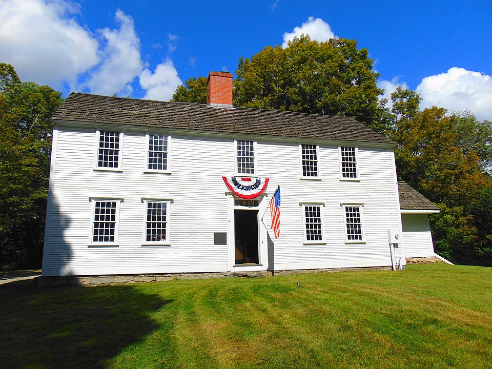
A National Historic Landmark. Listed on the National Register of Historic Places in 1971.
From the record
“The Huntington Homestead, also known as the Samuel Huntington Birthplace, is a historic house museum and National Historic Landmark at 36 Huntington Road in Scotland, Connecticut. Built in the early 18th century, it was the birthplace and boyhood home of Samuel Huntington (1731-1796), an American statesman and Founding Father.”
Wikipedia article Samuel Huntington Birthplace, CC BY-SA 4.0.
One of 82 National Register listings published here for Windham County · listed in 1971 · category: Building · a National Historic Landmark.
National Register reference number.71001009- the number the National Park Service assigned this property when it was listed, and the key its nomination file is catalogued under at the National Archives.
This ancient parish after repeated struggles achieved its hidependcnce in 1857. Its first town meeting was held on the morning of July 4th, in the vestry of the Congregational house of worship. Jephtha (jreen, moderator. Jkmjamin llovey was chosen clerk and treasurer ; John P. Gager, Zephaniah l*almer, John P. Webb, selectmen ; Henry Webb, constable. A p]ea8ant social gathering was held in the afternoon, when patriotic and congratulatory addresses were made by Governor Cleveland, liev. Mr. Tallnian, and native citizens. Change of status nmde little practic:d difference in local administration. A slight change in the fonner west bound brought the Main Brick works and the old Itobinson house with it-s monthly religious services within the town. llev. Thomas Tallman resigned the pastorate of the Congregational church in 1801. A meeting-house had been built in the village in 1843, by the Univei-salist society, II. Slade, pastor. Dr. C. II. Hrondey practiced medicine for many years. No special events have occurred since town organization. Youngest and smallest of Windham County towns, with no special business facilities, Scotland can hardly be expected to Uike a conspicuous position. The sons of David L. Fuller, Esq., engaged about 1850, in a clothing manufacture, sending out garments to be made throughout all the adjacent towns, and conducting a branch establishment in Thompson, but they followed the westward movement, and devoted their energies to building up St. Paul and Minnesota, while other young men have won success in varied fields. Restricted in present compass an«l population, Scotland abounds in historic memorial. She can show us the birthplace of Hon. Samuel Huntington ; the early homes of Daniel Waldo,* the famous centenarian chaplain of Congress, and the more distinguished artist, Sanmel Waldof ; the old Devotion homestead with its lievolutionary associations, and the homes of other ancient fannilies which sent out names now known throughout the laud. Inspire<l by
THE township of Scotland, lying in the southwestern part of the Qounty, is about six miles long from north to south, and about three miles wide. It lies on the southern border of the county, being bounded on the north by Hampton and a small part of Chaplin, on the east by Canterbury, on the south by Lisbon and Franklin, in the county of New London, and on the west by Windham. It comprehends about eighteen square miles of territory, much of which is hilly and in a wild condition. This is particularly true of the northern part of the town. In the central and southern parts there is a great deal of good farming land, and the improved farms and residences give a very attractive and home like appearance to the country. The surface is sufl&ciently rolling to make the rural landscape fascinatingly picturesque. Merrick's brook runs down through the middle of the town, joining the Shetucket in the southwest corner of the town. The Providence Division of the New York & New England railroad also runs with the Shetucket river across the southwest corner of the town. Here is Waldo's station, a locality surrounded by swamps and woods, an ancient saw mill having once been in operation near by on the stream already mentioned. Scotland presents to the passer-by one of those ripened communities in which the people are quietly and peacefully enjoying the fruits of labor performed in former years, rather than living on the sweat of present activities. The surrounding forest growth affords considerable timber, which is utilized in railroad ties. Scotland in 1870 had a population of 648 ; in 1880 the population was reduced to 590. As the history of the town is but little more than the history of the ecclesiastical society out of which it grew, we shall address ourselves at once to the consideration of that subject.
Regional context, not property-specific
evidence. The
federal wildfire occurrence database
lists 74 fires within 5 miles of Samuel Huntington Birthplace
between 1993 and 2020, burning about 112 acres in total. 2 started naturally. 9 were recorded as arson.
Distance is straight-line from the map coordinates, so a fire counted
here may appear on a neighbouring settlement's page as well.
Reported cause
Fires
Missing data/not specified/undetermined
49
Arson/incendiarism
9
Misuse of fire by a minor
8
Recreation and ceremony
4
Natural
2
Debris and open burning
1
Smoking
1
The most recent of
them, most recent first, with the day each was reported and the service
that recorded it.
Regional context, not property-specific
evidence. The federal mineral resources record lists
12 workings within 5 miles of Samuel Huntington Birthplace: 7 past producers, 4 producers, 1 unknown.
4 still produce. What was taken out: Sand and Gravel, Construction, Stone, Dimension, Stone, Granite. Distance is straight-line from the
map coordinates, so a quarry counted here may appear on a neighbouring
settlement's page as well.
Regional context, not property-specific
evidence. The National Weather Service names
Scotland, the town this property stands in, in 10 storm reports between 1993 and 2023: 8 thunderstorm wind, 1 hail, 1 tornado.
No death or injury is recorded in these reports. Each account below is quoted exactly as the forecast office
filed it, from the NOAA Storm Events Database, and each date
opens the federal record of that event.
A tornado caused damage in the town of Scotland, located in|Windham County, CT. The tornado touched down on Bass Road and continued along Route 14 (Huntington Road) and crossed Pinch Street before it eventually|lifted near Brook Road. While there wasn't much in the way of structural damage observed, other than gutter damage to two homes, there was significant tree|damage. It was estimated that well over one hundred trees were|either downed or sheared off at their tops.
In Scotland, a tree fell onto a house on the 170 block of Kemp Road. A tree and wires were down at three locations on Kemp Road, as well as on Brooklyn Turnpike and Cemetery Road.
At 304 PM EST, the Connecticut Department of Transportation and amateur radio operators reported multiple trees down on wires in Scotland, including at the junction of route 97 and route 14.
No historic map-sheet match is published
for this property yet. That does not mean no map exists. This record needs
a coordinate-quality review before it can be joined to a sheet boundary.
Browse the county's mapped places while that work is
pending.
Listed places nearby
6 within 8 miles
Other National Register properties close
enough to walk or drive between, ordered by distance from this one. Both
positions come from the same geocoding pass that matched these properties
to their map sheets.
Listing record. National Park Service National Register of Historic Places, listed-properties dataset, current to 2026-05-22.
Map join. Address geocoded through the United States Census geocoder, then tested against the published boundary of every sheet in the USGS Historical Topographic Map Collection.
How this page is made. Listing fields come from federal records; map-sheet coverage is a labelled coordinate-to-boundary calculation, not a source-field claim.
Wildfire. Short, Karen C. 2022. Spatial wildfire occurrence data for the United States, 1992-2020 [FPA_FOD_20221014]. 6th Edition. Fort Collins, CO: Forest Service Research Data Archive. https://doi.org/10.2737/RDS-2013-0009.6 Collected with United States Government funding and usable without additional permissions or fees.
Mines and quarries. USGS Mineral Resources Data System (MRDS) https://mrdata.usgs.gov/mrds/ A work of the United States government, no copyright under 17 U.S.C. 105.
Storms. NOAA National Centers for Environmental Information, Storm Events Database https://www.ncei.noaa.gov/stormevents/ A work of the United States government, no copyright under 17 U.S.C. 105. Narratives are quoted verbatim from the National Weather Service report and are not edited or summarised.
 Block