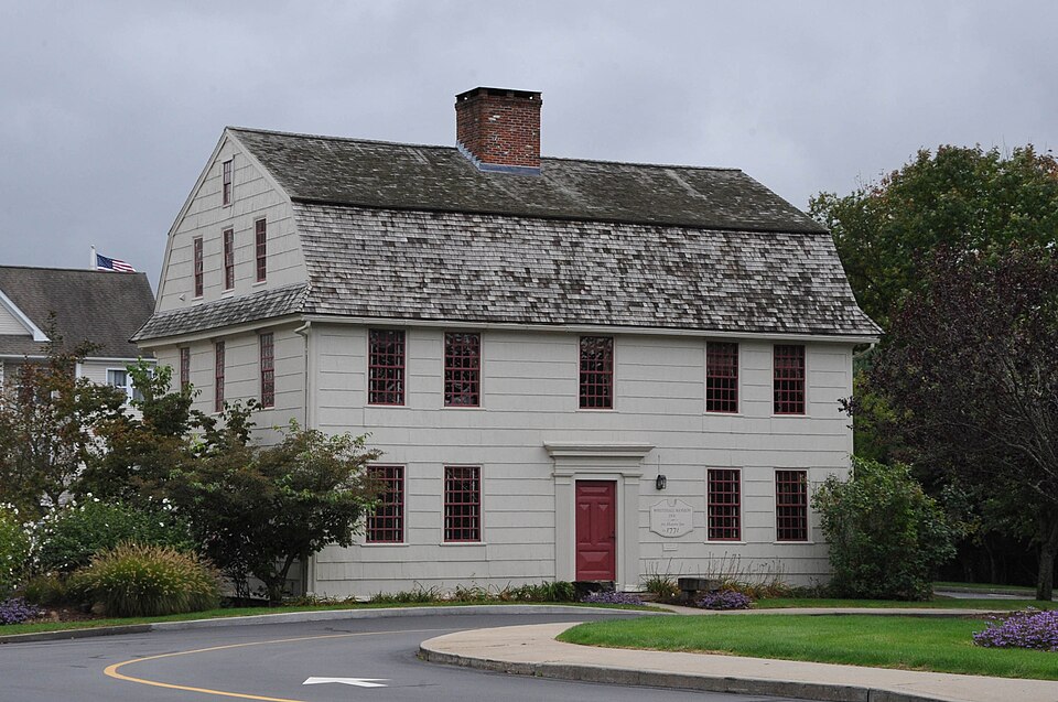
Listed on the National Register of Historic Places in 1979.
From the record
“The Whitehall Mansion is a historic house at 42 Whitehall Avenue in the Stonington side of Mystic, Connecticut. Built about 1771 for a local physician and politician, it is a fine example of late Georgian architecture.”
Wikipedia article Whitehall Mansion, CC BY-SA 4.0.
One of 197 National Register listings published here for New London County · listed in 1979 · category: Building.
National Register reference number.79002647- the number the National Park Service assigned this property when it was listed, and the key its nomination file is catalogued under at the National Archives.
Nothing of interest beyond the ordinary transactions of business occurred here until the war-clouds again appeared between the United States and Great Britain. The embargo acts of Congress, which were so severely denounced and resisted in almost all of New England, found active and influential defenders here. In order to give force and expression to their views on that subject, a town-meeting was called and held as follows : " At a town-meeting legally warned and held at Stonington, on the 27th day of March, A.D. 1809, the following preamble and resolutions were adopted by a major vote:
The determination of the British government to impress American seamen into their service, and other belligerent acts on her part, led to several armed collisions, and finally culminated in a declaration of war by the United States government against Great Britain, June 18, 1812. Very little had ever been done by the general government for the defense of our sea-coast. Long Point, since the close of the Revolution, had materially increased in population and wealth. The General Assembly had incorporated the place into a borough in 1801. Mystic was but a small village at the time, composed .largely of enterprising seafaring men. Before the embargo the foreign trade of the town of Stonington was almost entirely with the West Indies, and generally productive of large gains. During the war, and especially after the spring of 1813, our sea-coast was blockaded by a British squadron, which at first wellnigh annihilated all our commerce, but a few brave, resolute, enterprising men ran the blockade and carried on business with New York. Privateers were fitted out, and were successful in most cases in capturing English vessels. We lost the sloop " Fox" in 1813, which was retaken by the privateer " Hero," fitted out at Mystic and manned by Stonington and Groton men. Other feats of heroism and successful daring, by Groton and Stonington men combined, took place on the ocean before the close of the war. During its first year England had her hands full with European conflicts, but in the spring of 1813 she managed to send a formidable fleet to our shores and blockaded Long Island Sound. Stonington borough had received two eighteen-pounders from the general government for the defense of the place. A battery had been erected there during the Revolution which had almost disappeared. But the inhabitants, with the guards stationed there, drafted from the militia of the State, had erected another battery, the north end of which terminated at the southeast corner of the Messrs. Atwood's silk-machinery establishment. So apprehensive were the people of Stonington borough that their village would be attacked and burned by the British fleet that they sought the aid of the State, the Governor of which ordered detachments from the militia to be drafted and stationed there. There were six of these military drafts and detachments, - three in 1813, and three in 1814-15, - four of which were commanded by Lieut. Horatio G. Lewis, one by Lieut. Samuel Hough, and one by Sergt. Peleg Hancox.
Regional context, not property-specific
evidence. The
federal wildfire occurrence database
lists 1 fire within 5 miles of Whitehall Mansion
in 2018, burning under an acre in total. None started naturally. None was recorded as arson.
Distance is straight-line from the map coordinates, so a fire counted
here may appear on a neighbouring settlement's page as well.
Reported cause
Fires
Debris and open burning
1
The most recent of
them, most recent first, with the day each was reported and the service
that recorded it.
Regional context, not property-specific
evidence. The federal mineral resources record lists
23 workings within 5 miles of Whitehall Mansion: 19 past producers, 4 producers.
4 still produce. What was taken out: Sand and Gravel, Construction, Stone, Dimension, Granite, Stone. Distance is straight-line from the
map coordinates, so a quarry counted here may appear on a neighbouring
settlement's page as well.
Regional context, not property-specific
evidence. The National Weather Service names
Stonington, the town this property stands in, in 14 storm reports between 1995 and 2024: 7 thunderstorm wind, 4 lightning, 2 flash flood, 1 hail.
The reports record 3 injuries. Each account below is quoted exactly as the forecast office
filed it, from the NOAA Storm Events Database, and each date
opens the federal record of that event.
A 48 year old man was struck by lightning as a thunderstorm moved through Stonington. He was working outside when the lightning strike occurred. The man was taken to a hopital in critical condition. It is unknown if the man ulimately survived.
Severe thunderstorms moving across eastern Connecticut caused a variety of weather problems. A few homes sustained considerable damage after being struck by lightning. A couple of men were lucky to be alive after being struck by lightning. Golf ball-size hail was reported in New London, but apparently did little, if any, damage. In Windham County numerous large trees were reported down in Plainfield. More than 9,000 electric customers lost power statewide.
No historic map-sheet match is published
for this property yet. That does not mean no map exists. This record needs
a coordinate-quality review before it can be joined to a sheet boundary.
Browse the county's mapped places while that work is
pending.
Listed places nearby
6 within 8 miles
Other National Register properties close
enough to walk or drive between, ordered by distance from this one. Both
positions come from the same geocoding pass that matched these properties
to their map sheets.
Listing record. National Park Service National Register of Historic Places, listed-properties dataset, current to 2026-05-22.
Map join. Address geocoded through the United States Census geocoder, then tested against the published boundary of every sheet in the USGS Historical Topographic Map Collection.
How this page is made. Listing fields come from federal records; map-sheet coverage is a labelled coordinate-to-boundary calculation, not a source-field claim.
Wildfire. Short, Karen C. 2022. Spatial wildfire occurrence data for the United States, 1992-2020 [FPA_FOD_20221014]. 6th Edition. Fort Collins, CO: Forest Service Research Data Archive. https://doi.org/10.2737/RDS-2013-0009.6 Collected with United States Government funding and usable without additional permissions or fees.
Mines and quarries. USGS Mineral Resources Data System (MRDS) https://mrdata.usgs.gov/mrds/ A work of the United States government, no copyright under 17 U.S.C. 105.
Storms. NOAA National Centers for Environmental Information, Storm Events Database https://www.ncei.noaa.gov/stormevents/ A work of the United States government, no copyright under 17 U.S.C. 105. Narratives are quoted verbatim from the National Weather Service report and are not edited or summarised.
 Block