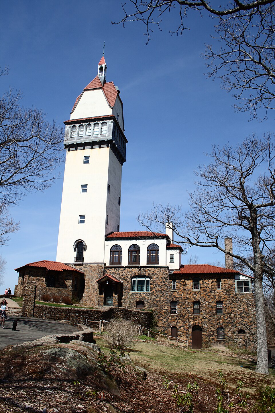
Built in 1914. Listed on the National Register of Historic Places in 1983.
From the record
“Heublein Tower is a 165-foot-tall (50 m) architectural tower located in Talcott Mountain State Park in Simsbury, Connecticut. It provides panoramic views of the Hartford skyline, the Farmington River Valley, and surrounding areas that are particularly spectacular in the fall.”
Wikipedia article Heublein Tower, CC BY-SA 4.0.
One of 451 National Register listings published here for Hartford County · listed in 1983 · category: Building · built in 1914, by Smith & Bassette.
National Register reference number.83001260- the number the National Park Service assigned this property when it was listed, and the key its nomination file is catalogued under at the National Archives.
BLOO^IFIELD was incorporated in 1835, and consisted of Wintonbiiry Parish and a portion of Poquonnock Society in Windsor. In 1840 the town received an addition of a part of Simsburv known as Scotland Parish. As now constituted, it is bounded on the north and east by Windsor, on the south by Hartford, and on the west by Simsbury and Avon, and averages four miles in length and in breadth. On the cast border a forest a mile and a half broad extends the whole length of the township from north to south, and on the west is the range of hills called Talcott Mountain. Tlirough this broad, gently undulating valley run three large brooks, which unite in the south part to form Woods River ; and this, meeting another small river in the southwest part of Hartford, forms Park River, which flows through the city and empties into the Connecticut. These three Bloomfield streams are all of slow current, and overflow their banks several times a year, thus greatly enriching the soil.
the Congregational Church, and he succeeded in restoring the harmony broken by disagreement on the choice of his predecessor, and by dissatisfaction with the Half-way Covenant. It was during his pastorate that a new meeting-house was built. The first one must have been sadly dila])idated and the people slow to realize it: for the Simsbury preacher, Mr. Stebbins, " a man intelligent, shrewd, and sarcastic," was sent for to stir them up on the subject. His text was, " Surely the fear of God is not in this place ;" and this was one sentence in his discourse : " When you pass through a village, and see the clapboards on the meeting-house hanging dingle-dangle by one nail, you may be sure the love of God is not in that people."
Regional context, not property-specific
evidence. The
federal wildfire occurrence database
lists 44 fires within 5 miles of Heublein Tower
between 1994 and 2020, burning about 110 acres in total. None started naturally. 5 were recorded as arson.
Distance is straight-line from the map coordinates, so a fire counted
here may appear on a neighbouring settlement's page as well.
Reported cause
Fires
Missing data/not specified/undetermined
22
Recreation and ceremony
7
Debris and open burning
6
Arson/incendiarism
5
Misuse of fire by a minor
3
Equipment and vehicle use
1
The most recent of
them, most recent first, with the day each was reported and the service
that recorded it.
Regional context, not property-specific
evidence. The federal mineral resources record lists
14 workings within 5 miles of Heublein Tower: 13 past producers, 1 plant.
1 still produces. What was taken out: Stone, Dimension, Sand and Gravel, Construction, Flagstone, Stone, Crushed/Broken. Distance is straight-line from the
map coordinates, so a quarry counted here may appear on a neighbouring
settlement's page as well.
Regional context, not property-specific
evidence. The National Weather Service names
Simsbury, the town this property stands in, in 26 storm reports between 1993 and 2025: 17 thunderstorm wind, 4 hail, 2 flash flood, 2 flood.
No death or injury is recorded in these reports. Each account below is quoted exactly as the forecast office
filed it, from the NOAA Storm Events Database, and each date
opens the federal record of that event.
Several mainstem rivers and small streams in Hartford County went into flood. These include the Farmington River at Tariffville, Unionville, and Simsbury, the Bunnell Brook at Burlington, and the Quinnipiac River at Southington. In addition, basements were flooded in Berlin and Avon. Several intersections were flooded, including the intersection of Old Farms and Tillotson Roads in Avon and the intersection of Wolcott and Wescott Roads in Simsbury. In New Britain, sewers backed up on Pierremount Avenue, flooding numerous houses.
Numerous roads were closed throughout Bloomfield because of water one to two feet deep over the roads. In addition, a ten foot section of Bloomfield Avenue was washed out near the intersection of Bloomfield Avenue and Route 218.
Large limbs were downed in Simsbury and Southington while lightning caused a fire which destroyed a hay-filled 200-year-old barn in Glastonbury. This lightning/wind event was the first of many in Connecticut that knocked out power to at least 44,000 customers that afternoon.
No historic map-sheet match is published
for this property yet. That does not mean no map exists. This record needs
a coordinate-quality review before it can be joined to a sheet boundary.
Browse the county's mapped places while that work is
pending.
Listed places nearby
6 within 8 miles
Other National Register properties close
enough to walk or drive between, ordered by distance from this one. Both
positions come from the same geocoding pass that matched these properties
to their map sheets.
Listing record. National Park Service National Register of Historic Places, listed-properties dataset, current to 2026-05-22.
Map join. Address geocoded through the United States Census geocoder, then tested against the published boundary of every sheet in the USGS Historical Topographic Map Collection.
How this page is made. Listing fields come from federal records; map-sheet coverage is a labelled coordinate-to-boundary calculation, not a source-field claim.
Wildfire. Short, Karen C. 2022. Spatial wildfire occurrence data for the United States, 1992-2020 [FPA_FOD_20221014]. 6th Edition. Fort Collins, CO: Forest Service Research Data Archive. https://doi.org/10.2737/RDS-2013-0009.6 Collected with United States Government funding and usable without additional permissions or fees.
Mines and quarries. USGS Mineral Resources Data System (MRDS) https://mrdata.usgs.gov/mrds/ A work of the United States government, no copyright under 17 U.S.C. 105.
Storms. NOAA National Centers for Environmental Information, Storm Events Database https://www.ncei.noaa.gov/stormevents/ A work of the United States government, no copyright under 17 U.S.C. 105. Narratives are quoted verbatim from the National Weather Service report and are not edited or summarised.
 Block