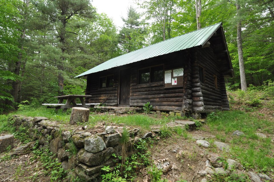
Built in 1937 (rustic architecture). Listed on the National Register of Historic Places in 1986.
From the record
“The Tunxis Forest Ski Cabin is a historic ski lodge at the end of Balance Rock Road in Tunxis State Forest, Hartland, Connecticut. Built in 1937, it is one of the few surviving ski-related recreational structures built by the Civilian Conservation Corps in the state.”
Wikipedia article Tunxis Forest Ski Cabin, CC BY-SA 4.0.
One of 451 National Register listings published here for Hartford County · listed in 1986 · category: Building · built in 1937, rustic architecture.
Also known as. Connecticut State Park and Forest Depression-Era Federal Work Relief Programs Structures TR
Town. Hartland town
When was it built? 1937
Architectural style. rustic architecture
National Register reference number.86001761- the number the National Park Service assigned this property when it was listed, and the key its nomination file is catalogued under at the National Archives.
The surface of the township is broken by a double range of hills north and south, and through it flow the east and west branches of Farmington River. The east branch rises in Norris Pond, near Tolland Centre, Mass. ; the west branch in Nichols Pond, in Becket, Mass. The town is liberally supplied with unfailing springs, and cold, clear streams that flow east and west. Hartland Pond covers about eighty acres in the northwest part of the town. The soil is a gravelly loam, except in the alluvial deposits of the valleys. Here and there coarse granite crops out on the hUls. The climate is cool, with a dry, bracing atmosphere. The natural woods are maple, beech, birch, ash, chestnut, cherry, and hemlock.
There is no evidence of any permanent settlement of Indians within the town, though arrow-heads and other implements found in the valleys show that they hunted here. The first white settler was John Kendall, who came from Granby and built his cabin in the south valley, east of where the old Bates house stands, now owned by Leonard Dickinson. His twin daughters were the first white children born in the town. He moved away in about a year, and the first permanent settler was Thomas Giddings, who came from Lyme, June 12, 1754. He made his home on the land so long owned by the late Willis Wright, in the southeast part of the town. Simon Baxter ^ came next. Joshua Giddings, brother of the lirst settler, came in 1756 from Lyme and located in the east parish, south of the centre, on the farm now owned by H. Searles. Jos^hua Giddings had three sons, John, Joshua, and Benjamin. John was the first wliite male child born in Hartland. Joshua, the second son, left Hartland for Pennsylvania, where, soon after, his son Joshua R. Giddings, the famous Abolitionist, was born. The third son, Benjamin, was the father of the Rev. Salmon Giddings, who in 1817 organized the first Protestant church in St. Louis and was installed over it.
Regional context, not property-specific
evidence. The
federal wildfire occurrence database
lists 38 fires within 5 miles of Tunxis Forest Ski Cabin
between 1999 and 2020, burning about 79 acres in total. 1 started naturally. 1 was recorded as arson.
Distance is straight-line from the map coordinates, so a fire counted
here may appear on a neighbouring settlement's page as well.
Reported cause
Fires
Missing data/not specified/undetermined
25
Recreation and ceremony
5
Debris and open burning
5
Arson/incendiarism
1
Natural
1
Power generation/transmission/distribution
1
The most recent of
them, most recent first, with the day each was reported and the service
that recorded it.
Regional context, not property-specific
evidence. The federal mineral resources record lists
6 workings within 5 miles of Tunxis Forest Ski Cabin: 4 past producers, 2 producers.
2 still produce. What was taken out: Talc-Soapstone, Feldspar, Quartz, Stone, Dimension, Mica. Distance is straight-line from the
map coordinates, so a quarry counted here may appear on a neighbouring
settlement's page as well.
Regional context, not property-specific
evidence. The National Weather Service names
Hartland, the town this property stands in, in 6 storm reports between 2001 and 2021: 3 hail, 2 thunderstorm wind, 1 tornado.
No death or injury is recorded in these reports. Each account below is quoted exactly as the forecast office
filed it, from the NOAA Storm Events Database, and each date
opens the federal record of that event.
No historic map-sheet match is published
for this property yet. That does not mean no map exists. This record needs
a coordinate-quality review before it can be joined to a sheet boundary.
Browse the county's mapped places while that work is
pending.
Listed places nearby
6 within 8 miles
Other National Register properties close
enough to walk or drive between, ordered by distance from this one. Both
positions come from the same geocoding pass that matched these properties
to their map sheets.
Listing record. National Park Service National Register of Historic Places, listed-properties dataset, current to 2026-05-22.
Map join. Address geocoded through the United States Census geocoder, then tested against the published boundary of every sheet in the USGS Historical Topographic Map Collection.
How this page is made. Listing fields come from federal records; map-sheet coverage is a labelled coordinate-to-boundary calculation, not a source-field claim.
Wildfire. Short, Karen C. 2022. Spatial wildfire occurrence data for the United States, 1992-2020 [FPA_FOD_20221014]. 6th Edition. Fort Collins, CO: Forest Service Research Data Archive. https://doi.org/10.2737/RDS-2013-0009.6 Collected with United States Government funding and usable without additional permissions or fees.
Mines and quarries. USGS Mineral Resources Data System (MRDS) https://mrdata.usgs.gov/mrds/ A work of the United States government, no copyright under 17 U.S.C. 105.
Storms. NOAA National Centers for Environmental Information, Storm Events Database https://www.ncei.noaa.gov/stormevents/ A work of the United States government, no copyright under 17 U.S.C. 105. Narratives are quoted verbatim from the National Weather Service report and are not edited or summarised.
 Block