BlockBefore

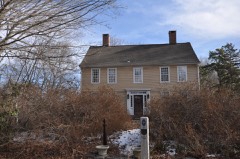
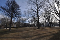
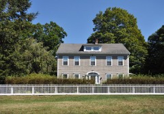
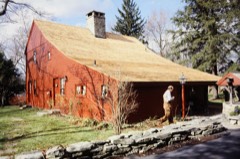
Nathan B. Lattin Farm

Listed on the National Register of Historic Places in 1990.

From the record

“Lattin Farm is a historic farm at 22 Walker Hill Road in Newtown, Connecticut. Founded by early colonial settlers to the area in the 18th century, it remains an example of a rural farm property in an increasingly suburbanized area.”

Wikipedia article Nathan B. Lattin Farm, CC BY-SA 4.0.

One of 298 National Register listings published here for Fairfield County · listed in 1990 · category: Building.

Sources: the Wikipedia article · the case file at the National Archives · the National Register database, National Park Service

The listing

  • Listed as. Lattin, Nathan B., Farm - the National Register files a house under its owner's surname.
  • Address. 22 Walker Hill Rd., Newtown, 06482
  • When was it listed? May 1990
  • Category. building
  • Town. Newtown town
  • National Register reference number. 90000760 - the number the National Park Service assigned this property when it was listed, and the key its nomination file is catalogued under at the National Archives.

The ground it stands on

2,459 words

The chapter on Newtown Town in History of Fairfield County, Connecticut : with Illustrations and Biographical Sketches of Its Prominent Men and Pioneers, published 1881 names Newtown. This is what it says, exactly as the scans read.

Among the prominent lawyers who were either born or practiced their profession in Newtown, was William Edmonds. He served in the Revolutionary war, and was wounded at the battle of Eidgefield and lay on the field over night. He afterwards became judge of the Superior Court.

Passage source: History of Fairfield County, Connecticut : with Illustrations and Biographical Sketches of Its Prominent Men and Pioneers, published 1881.

PHYSICIANS. The first disciple of ^Esculapius in Newtown was Dr. Gideon Shepherd. He was followed by Bennet Perry, Oliver Bancroft, John Judson, Thomas D. Shepherd, C. H. Booth, Dr. Shelton, Dr. Skidmore, George Judson, Erastus Erwiii, Thomas Dutton, and Graves.

Passage source: History of Fairfield County, Connecticut : with Illustrations and Biographical Sketches of Its Prominent Men and Pioneers, published 1881.

Machine-read from a century-old scan, so expect the errors a machine makes: misspelled names, dropped words, stray characters.

Read the whole chapter on Newtown Town - 2,459 words on its settlement, mills, schools and churches.

Fires near this property

78 since 1994

Regional context, not property-specific evidence. The federal wildfire occurrence database lists 78 fires within 5 miles of Nathan B. Lattin Farm between 1994 and 2020, burning about 86 acres in total. None started naturally. 2 were recorded as arson. Distance is straight-line from the map coordinates, so a fire counted here may appear on a neighbouring settlement's page as well.

Reported cause Fires
Missing data/not specified/undetermined63
Railroad operations and maintenance4
Misuse of fire by a minor3
Recreation and ceremony3
Arson/incendiarism2
Debris and open burning1
Smoking1
Equipment and vehicle use1

The most recent of them, most recent first, with the day each was reported and the service that recorded it.

DateCause SizeReported by Name on the report
3 September 2020Missing data/not specified/undeterminedunder an acreConnecticut Division of Forestry838 MAIN STREET
29 September 2015Missing data/not specified/undeterminedunder an acreConnecticut Division of Forestrynot named
19 September 2020Missing data/not specified/undetermined1.5 acresConnecticut Division of Forestry51 OLD TANNERY ROAD
16 September 2020Missing data/not specified/undetermined1.5 acresConnecticut Division of ForestryHERITANG DRIVE
30 August 2016Missing data/not specified/undeterminedunder an acreConnecticut Division of ForestryLAKE ZOAR WMA
2 August 2020Missing data/not specified/undeterminedunder an acreConnecticut Division of Forestry78 GAY BOWER ROAD
2 August 1999Recreation and ceremonyunder an acreConnecticut Division of Forestrynot named
5 July 2017Missing data/not specified/undeterminedunder an acreConnecticut Division of ForestryHART CT

Every fire recorded in Fairfield County

Mines and quarries near this property

10 of 29 shown

Regional context, not property-specific evidence. The federal mineral resources record lists 29 workings within 5 miles of Nathan B. Lattin Farm: 24 past producers, 3 producers, 2 occurrences. 3 still produce. What was taken out: Sand and Gravel, Construction, Bismuth, Limestone, General, Feldspar. Distance is straight-line from the map coordinates, so a quarry counted here may appear on a neighbouring settlement's page as well.

Where SiteCommodity StatusRecorded
Arsenopyrite Mine No. Ek-017Arsenic, Iron, SulfurPast Producer
Connecticut Infusoria Co. MineDiatomitePast Producer
Devils Den Limestone QuarryLimestone, DimensionPast Producer
East Village Monroe Feldspar Pegmatite QuarryFeldspar, QuartzPast ProducerBeryl, Columbite, Feldspar, Garnet
Gneiss Rock Quarry No. Ek-006StonePast Producer
Lane's Bismuth and Sulfide Mine In MonroeBismuth, Sulfur, IronPast ProducerMassive Quartz Lense
Lane's MineTungstenPast Producer
Lane's MineLead, Bismuth, Stone, TungstenPast Producer
Marble QuarryMarble, DimensionPast Producer
Monroe (Lane's Mine)Silver, Bismuth, TungstenOccurrenceQuartz Vein

Every working recorded in Fairfield County

Storms near this property

26 since 1996

Regional context, not property-specific evidence. The National Weather Service names Newtown, the town this property stands in, in 26 storm reports between 1996 and 2024: 19 thunderstorm wind, 3 hail, 2 lightning, 1 flash flood. The reports record 1 injury. Each account below is quoted exactly as the forecast office filed it, from the NOAA Storm Events Database, and each date opens the federal record of that event.

WhenEvent Place namedHarm What the report says
July 1997LightningNewtown1 hurtno account filed
June 2010Thunderstorm WindNewtown$35,000Numerous trees and power lines were downed throughout Newtown. Over 11,000 customers lost power in the region. Over 25 roads were closed due to the damage.
October 2020Thunderstorm WindNewtown$10,000Multiple reports of large branches and wires down across town.
May 2018Thunderstorm WindNewtown$10,000Numerous roads closed due to downed trees in the Newtown / Monroe area.
July 2008Thunderstorm WindNewtown$10,000Utility lines and several trees, including a massive tree, were downed in Newtown. A tree went through the roof of a residence, and a small fire was set by downed wires. Main Street was closed for several hours.
June 2024Thunderstorm WindNewtown$8,000Dozens of reports across Newtown involving downed trees with a few of them involving wires.
June 2010Thunderstorm WindNewtown$8,000Numerous trees and wires were downed in Newtown. The areas impacted most heavily ranged from the center of town to the Route 302 and Route 6 areas.
May 2018Thunderstorm WindNewtown$5,000At Gelding Hill Road, numerous trees down. Power lines down.
July 2014LightningNewtown$5,000A house was struck on Elona Lane.
July 2014Thunderstorm WindNewtown$4,000Several trees and wires were reported down around the town.
July 2014Thunderstorm WindNewtown$2,000Multiple trees were reported down at the intersection of Glen Road and Cherry Street.
July 2014Thunderstorm WindNewtown$2,000Numerous trees were reported down around the town of Newtown.
May 2009Thunderstorm WindNewtown$1,000Trees fell on wires on Sugar Hill Road.
May 2009Thunderstorm WindNewtown$1,000A tree fell on wires at 4 Nelson Lane.
March 2019HailNewtown-Hail of 0.75 inches in diameter reported.
March 2019HailNewtown-Half dollar size hail reported with size estimated from picture.
May 2007Thunderstorm WindNewtown-Numerous trees down.
June 2007Thunderstorm WindNewtown-Downed trees.
May 2007Tornado (EF1)Newtown-An EF-1 tornado touched down near the Rock Ridge Country Club, just north of Route 302. It traveled east to northeast and passed just south of the main town center in Newtown. The tornado passed across Route 25, South Main Street and lifted along Sugarloaf Road, between Toddy Hill Road and Berkshire Drive.||High winds damaged many trees which fell through houses and cars along this path, which was approximately 4.5 miles with an average path width of 100 yards. There was a well defined narrow track of discontinuous damage, where the damage converged in toward the track center. Eye witness reports of funnel clouds were observed.||
June 2007HailNewtown-no account filed
June 2001Thunderstorm WindNewtown-no account filed
August 2001Thunderstorm WindNewtown-no account filed
July 2000Flash FloodNewtown-no account filed
August 1998Thunderstorm WindNewtown-no account filed
August 1996Thunderstorm WindNewtown-no account filed

Every storm recorded in Fairfield County

Map coverage status

No historic map-sheet match is published for this property yet. That does not mean no map exists. This record needs a coordinate-quality review before it can be joined to a sheet boundary. Browse the county's mapped places while that work is pending.

Listed places nearby

6 within 8 miles

Other National Register properties close enough to walk or drive between, ordered by distance from this one. Both positions come from the same geocoding pass that matched these properties to their map sheets.

Photograph PropertyDistance Listed
Daniel Basset House1.6 miles2002
Stevenson Dam Hydroelectric Plant2.3 miles2000
Monroe Center Historic District2.5 miles1977
Fairfield Hills Campus Historic District4.5 miles2024
Sanford-Curtis-Thurber House4.7 miles2007
Thomas Hawley House5.0 miles1980

Sources for this property

National Archives recordThe nomination case file for reference 90000760 in Record Group 79.
Wikipedia articleCommunity-written account of this property, licensed CC BY-SA.
Fairfield CountyAll 298 listed properties in this county.

Provenance

  • Listing record. National Park Service National Register of Historic Places, listed-properties dataset, current to 2026-05-22.
  • Map join. Address geocoded through the United States Census geocoder, then tested against the published boundary of every sheet in the USGS Historical Topographic Map Collection.
  • How this page is made. Listing fields come from federal records; map-sheet coverage is a labelled coordinate-to-boundary calculation, not a source-field claim.
  • Wildfire. Short, Karen C. 2022. Spatial wildfire occurrence data for the United States, 1992-2020 [FPA_FOD_20221014]. 6th Edition. Fort Collins, CO: Forest Service Research Data Archive. https://doi.org/10.2737/RDS-2013-0009.6 Collected with United States Government funding and usable without additional permissions or fees.
  • Mines and quarries. USGS Mineral Resources Data System (MRDS) https://mrdata.usgs.gov/mrds/ A work of the United States government, no copyright under 17 U.S.C. 105.
  • Storms. NOAA National Centers for Environmental Information, Storm Events Database https://www.ncei.noaa.gov/stormevents/ A work of the United States government, no copyright under 17 U.S.C. 105. Narratives are quoted verbatim from the National Weather Service report and are not edited or summarised.