 Block
BlockJupiter, Florida
15 topographic sheets cover this place, the earliest surveyed in 1948 and the latest in 1987. It stands in the Jupiter census division. It lies in ZIP code area 33458. It stands on Southwest Fork Loxahatchee River. The Survey maps it on the Jupiter quadrangle. 61,047 people lived here at the 2020 count. It stands 7 feet above sea level.
Then and now
1948 to 1987The same ground, surveyed 39 years apart. Drag the handle to wipe between them. Both sheets are United States Geological Survey originals; neither has been altered.
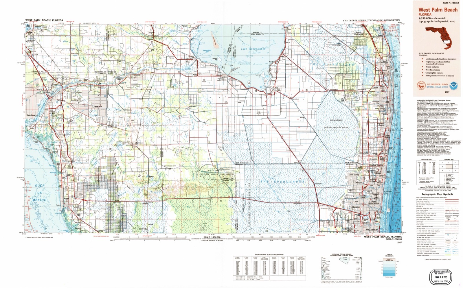
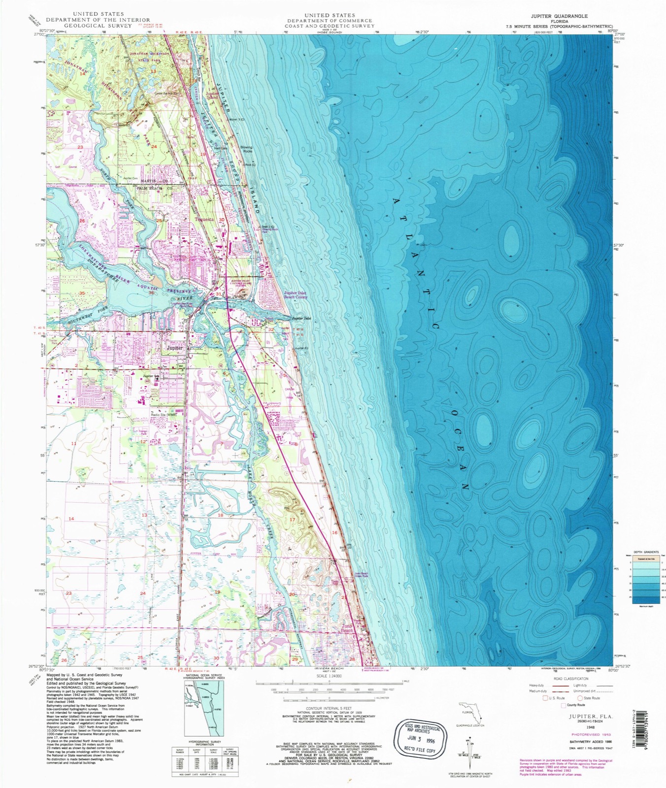
Compare 1948 against another survey:
On record in Jupiter
Buildings and businesses the archive holds for this place. Each opens its own page, with the source record it came from.
On the National Register 2 records
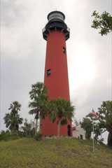 Jupiter Inlet Lighthouselisted 1973
- Loxahatchee Battlefieldlisted 2024
Population over time
2 figuresJupiter grew from 55,156 to 61,047 between 2010 and 2020. These are the recorded population figures Wikidata holds for this place, reached through the Geographic Names Information System number this page is keyed on rather than by name, so they belong to this place and not to another of the same name. Most are census counts, but not all are: an early figure may be a founding or settlement estimate, and an estimate published within five years of a census is left out. The change column is computed, and is left blank where more than 20 years separate a figure from the one before it, because a gap that long is not a change between two counts.
| Year | People | Change |
|---|---|---|
| 2010 | 55,156 | |
| 2020 | 61,047 | +5,891 (+11%) |
Topographic sheets covering this place
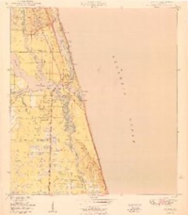
8 surveys from 15 printed sheetsMatched by testing this settlement's coordinate against the published boundary of every sheet in the United States Geological Survey's historical collection. Each opens the scanned sheet at the Survey.
- 1948 USGS Jupiter quadrangle1:24000, 5 printings
- 1950 USGS Jupiter quadrangle1:24000
- 1956 USGS West Palm Beach quadrangle1:250000, 2 printings
- 1957 USGS West Palm Beach quadrangle1:250000
- 1958 USGS West Palm Beach quadrangle1:250000, 2 printings
- 1981 USGS West Palm Beach quadrangle1:100000
- 1985 USGS West Palm Beach quadrangle1:100000
- 1987 USGS West Palm Beach quadrangle1:250000, 2 printings




Fires near this place
82 since 1992Regional context, not property-specific evidence. The federal wildfire occurrence database lists 82 fires within 5 miles of Jupiter between 1992 and 2020, burning about 2,215 acres in total. 36 started naturally. 4 were recorded as arson. Distance is straight-line from the map coordinates, so a fire counted here may appear on a neighbouring settlement's page as well.
| Reported cause | Fires |
|---|---|
| Natural | 36 |
| Misuse of fire by a minor | 11 |
| Missing data/not specified/undetermined | 9 |
| Railroad operations and maintenance | 6 |
| Recreation and ceremony | 5 |
| Arson/incendiarism | 4 |
| Smoking | 3 |
| Debris and open burning | 3 |
| Power generation/transmission/distribution | 3 |
| Equipment and vehicle use | 1 |
| Fireworks | 1 |
The most recent of them, most recent first, with the day each was reported and the service that recorded it.
| Date | Cause | Size | Reported by | Name on the report |
|---|---|---|---|---|
| 7 September 1993 | Railroad operations and maintenance | 1.5 acres | Florida Forest Service | not named |
| 2 September 1993 | Missing data/not specified/undetermined | 2.0 acres | Florida Forest Service | not named |
| 7 August 2009 | Natural | 2.0 acres | Florida Forest Service | HOOD ROAD |
| 7 August 2005 | Natural | 15 acres | Florida Forest Service | SCHOOL CMND |
| 3 August 2005 | Power generation/transmission/distribution | under an acre | Hobe Sound National Wildlife Refuge | LINE DOWN |
| 3 August 1998 | Natural | 3.0 acres | Florida Forest Service | not named |
| 27 August 2004 | Natural | 3.5 acres | Florida Forest Service | NORTH LAKE 2 FIRE |
| 14 August 2010 | Natural | 1.0 acres | Florida Forest Service | (MA) SANDY PINES (461) |
Settlements close enough to share some of these fires:
Storms near this place
60 of 64 shownRegional context, not property-specific evidence. The National Weather Service names Jupiter in 64 storm reports between 1996 and 2023: 18 hail, 12 lightning, 12 thunderstorm wind, 6 funnel cloud. The reports record 1 death and 7 injuries. Each account below is quoted exactly as the forecast office filed it, from the NOAA Storm Events Database, and each date opens the federal record of that event.
| When | Event | Place named | Harm | What the report says |
|---|---|---|---|---|
| August 2002 | Lightning | Jupiter | 1 killed | A 28-year old man working on a roof at the Admiral's Cove subdivision was struck by lightning and mortally injured. He was holding roof flashing and a metal tray when the lightning struck.. He was transported to the hospital where he died 9 days later. |
| July 2005 | Lightning | Jupiter | 2 hurt | Two boys, ages 15 and 16, were knocked unconscious while standing under a tree in the woods, next to a canal. The 15-year-old was struck in the head and suffered cardiac arrest, but later recovered. It was just beginning to rain at the time. |
| June 2010 | Lightning | Jupiter | 1 hurt | A 19-year-old woman was shocked by a lightning strike which struck about 25 feet from her home's driveway as she was outside loading clothes into a vehicle. The woman was 8 months pregnant. The victim was taken to a nearby hospital and was released the same day. |
| June 2003 | Lightning | Jupiter | 1 hurt | A 21-year old male was seriously injured by lightning as he stood in his sister's backyard while visiting from New York. The lightning struck the ground and flashed off of swing set to the victim. The thunderstorm "had just rolled in". |
| June 2002 | Lightning | Jupiter | 1 hurt | A 47-year old man was injured when lightning struck the metal railing on which he was leaning on the second floor of his condominium. |
| August 1998 | Lightning | Jupiter | 1 hurt | A man picnicking at Dubois Park near Jupiter Inlet was knocked unconscious by a lightning strike that forced him to the ground as it hit a tree near him. |
| June 1999 | Lightning | Jupiter | 1 hurt | no account filed |
| September 2001 | Lightning | Jupiter | $500,000 | A lightning-initiated fire which started on the roof severely damaged a house in Admirals Cove. |
| August 2003 | Tornado (F0) | Jupiter | $50,000 | A tornado, most likely spawned by the interaction of the sea breeze and outflows from other thunderstorms, touched down in southeast Jupiter near Highway U.S. 1 and moved south for 1.5 miles, ending in the Falls Subdivision. Damage occurred to a metal roof in a shopping center and to screened porches, as well as to trees and shrubbery. |
| June 2002 | Thunderstorm Wind | Jupiter | $20,000 | no account filed |
| June 2015 | Tornado (EF0) | Jupiter | $5,000 | Video obtained from West Palm Beach broadcast media showed a likely tornadic circulation at the County Line Plaza in Tequesta. Damage appeared to be limited to uprooted trees in the parking lot and roofing material. The roof at the shopping center was undergoing repair at the time of the tornado, therefore much of the roofing material was already detached from the structure. Water entered a business in the plaza from one of the sections where the roof was being repaired. This tornado eventually moved into the Intracoastal waterway. |
| May 2020 | Thunderstorm Wind | Jupiter | $4,000 | Law enforcement reported a tree down, or a large portion of a tree down, on the road in the vicinity of the intersection of A1A and Toney Penna Drive, requiring maintenance intervention for cleaning. This wind damage was in association with a cluster of thunderstorms that crossed portions of Palm Beach County during the afternoon hours. Estimated wind gust in the 50 to 60 kt (60-65 mph) range. |
| April 2021 | Thunderstorm Wind | Jupiter | $1,000 | Multiple reports and pictures from social media in the Tequesta area include downed trees and power lines and damage to a railroad crossing gate. |
| April 2021 | Thunderstorm Wind | Jupiter | $1,000 | Social media reported small hardwood tree downed in Jupiter Farms. Time estimated from radar. |
| August 2000 | Lightning | Jupiter | $1,000 | Lightning struck the Jupiter Inlet Lighthouse tearing out a small piece of concrete and damaging the wiring. |
| September 2015 | Lightning | Jupiter | $500 | Lightning struck a garage roof of a home in Jupiter Landings. Palm Beach County Fire Rescue and Florida Power & Light officials responded and found a damaged rafter under the shingles, a charred electrical line and blown circuit. |
| April 2023 | Hail | Jupiter | - | Numerous public spotter reports of golf ball sized hail in Jupiter Farms. |
| April 2023 | Hail | Jupiter | - | Trained spotter reported quarter sized hail and heavy rain in Jupiter Farms. |
| April 2023 | Hail | Jupiter | - | The broadcast media reported quarter to ping pong ball sized hail fell in the Jupiter and Jupiter Farms areas. |
| October 2022 | Flash Flood | Jupiter | - | Law enforcement reports and pictures relayed from broadcast media indicated numerous areas of street flooding in Jupiter and Tequesta. Main areas include US 1 and Beach Road, Bridge Road and Old Dixie Hwy, Willow Rd and Tequesta Drive, Alt A1A and Eganfuskee Road, Cypress Dr. and Riverside Dr, and Old Dixie Hwy and Eyeball Avenue. A few cars were seen stalled in one of the pictures.||Law enforcement was required to close the following intersections: A1A and US-1, US-1 and Bridge Road, and A1A and Center Street. Rainfall observations from across the area were in the 5-7 inch range in just over 2 hours. |
| May 2022 | Hail | Jupiter | - | Quarter sized hail was reported near Indiantown Road and 103rd Terrace. |
| May 2022 | Hail | Jupiter | - | Nickel-size hail was reported in Jupiter Farms. |
| June 2022 | Flood | Jupiter | - | Reports were received of street flooding in Tequesta associated with two rounds of thunderstorms moving through the area. Over 3 inches of rain was measured in the area. |
| November 2020 | Flood | Jupiter | - | Town of Jupiter reported flooding of roadways north of Old Dixie Highway, north of Center Street, due to heavy rainfall from showers and thunderstorms. |
| October 2020 | Flood | Jupiter | - | Tequesta Police Department reported the interesection of Tequesta Drive and Old Dixie Highway was closed due to ponding of water. Rain gauges in the area measured 4 to 6 inches of rainfall in only a few hours. |
| June 2020 | Flash Flood | Jupiter | - | Multiple reports from the Town of Jupiter Police Dispatch of blocked, impassable streets and vehicles stranded in the 400 block of Hugh street and Near the Jupiter River Estates neighborhood. Social media posts by WPTV and CBS 12 in Palm Beach also showed half-foot of water on SR 811/Alt A1A in Jupiter and water completely covering Pittsburgh Drive in Jupiter, with water reaching about halfway up front yards. A total of 3 to 4 inches fell in that area, most of it in about an hour's time. |
| June 2020 | Flash Flood | Jupiter | - | Tequesta Police Department reported numerous streets flooded in the town from significant flooding. Streets included: Old Dixie Highway, Country Club Drive, Fairway West, Riverside Drive, and Yacht Club Place. Water was between waist and knee high in these areas. Several vehicles had to be towed/pushed from deep water. Over 4 inches of rain was measured by nearby gauges, with hourly rates of over 3 inches per hour. |
| June 2020 | Flash Flood | Jupiter | - | Report from the Town of Jupiter Police Dispatch of US 1 and South Beach Road being blocked, with one or two cars stranded due to flooding. A total of 3 to 4 inches of rain fell in the area, most of it in about one hour. |
| June 2019 | Funnel Cloud | Jupiter | - | Multiple reports, photos and video of a funnel cloud associated with a shower near Jupiter this afternoon. |
| March 2016 | Hail | Jupiter | - | A trained spotter reported dime sized hail in Jupiter. |
| April 2016 | Hail | Jupiter | - | Nickel sized hail was reported in Tequesta from the public via Twitter. |
| June 2015 | Thunderstorm Wind | Jupiter | - | Report relayed via Broadcast Media of trees uprooted along El Portal Drive and Golfview Drive in the Tequesta Country Club. This was from the same storm that eventually produced the tornado/waterspout along US 1 and the Indian River along the county line. |
| June 2015 | Thunderstorm Wind | Jupiter | - | Trees were reported down in Tequesta. |
| September 2015 | Hail | Jupiter | - | Penny to nickel-sized hail reported via social media. |
| July 2015 | Thunderstorm Wind | Jupiter | - | Power lines were down at US1 and Beach Road. The report was relayed via Broadcast Media. |
| December 2015 | Heavy Rain | Jupiter | - | Street flooding reported along the 300 block of A1A, and along US1 and Alt A1A in Jupiter. Flood waters quickly receded after rain ended. |
| August 2013 | Funnel Cloud | Jupiter | - | A funnel cloud was reported near the intersection of Indiantown Road and west of the Florida Turnpike. |
| April 2013 | Hail | Jupiter | - | The public reported quarter sized hail 1 mile northwest of Tequesta. |
| May 2012 | Hail | Jupiter | - | Media relayed a report of nickel-sized hail in Jupiter Farms. |
| April 2011 | Hail | Jupiter | - | Public reported nickel size hail near Bee line Hwy and Indiantown Road. |
| June 2011 | Hail | Jupiter | - | Nickel sized hail and winds estimated of 50 mph in Jupiter Farms near Sandy Run and 115 ST north. |
| June 2011 | Thunderstorm Wind | Jupiter | - | Winds were estimated to be 60 mph or higher at 127 Drive North in Jupiter Farms. |
| June 2011 | Funnel Cloud | Jupiter | - | A Sheriffs deputy from Palm Beach County reported a funnel cloud near the intersection of Indiantown road and i-95 at 725 PM EDT. |
| August 2010 | Flash Flood | Jupiter | - | A spotter reported severe street flooding in Jupiter with Central Blvd and Indian Creek Parkway closed. Rainfall reports from the area were of 3.75 inches of rain in only 45 minutes. |
| June 2009 | Hail | Jupiter | - | Jupiter police department reported quarter size hail. |
| July 2009 | Hail | Jupiter | - | The public reported nickel to dime sized hail accompanied with 50 mph wind gusts and over 1 inch of rain in 1/2 hour at Jupiter Farms. |
| July 2009 | Hail | Jupiter | - | The public reported 1 inch hail in Jupiter with a thunderstorm. |
| June 2009 | Thunderstorm Wind | Jupiter | - | Power lines were reported down in Jupiter. Time estimate based on radar data. |
| April 2006 | Thunderstorm Wind | Jupiter | - | Media reported downed telephone poles in Jupiter. |
| May 2005 | Hail | Jupiter | - | Penny-size hail was reported. |
| August 2004 | Funnel Cloud | Jupiter | - | A SKYWARN spotter saw a funnel cloud. |
| September 2004 | Funnel Cloud | Jupiter | - | A SKYWARN spotter saw a funnel cloud that quickly dissipated. |
| September 2004 | Tornado (F0) | Jupiter | - | A tornado briefly touched down near Central Boulevard and I-95. |
| July 1998 | Waterspout | Jupiter | - | Waterspout sighted 3nm east of Jupiter. Also reported in a Pilot Report. |
| July 2007 | Thunderstorm Wind | Jupiter | - | no account filed |
| September 2005 | Heavy Rain | Jupiter | - | no account filed |
| March 2003 | Thunderstorm Wind | Jupiter | - | no account filed |
| March 2003 | Hail | Jupiter | - | no account filed |
| June 2002 | Lightning | Jupiter | - | no account filed |
| June 2000 | Wildfire | Jupiter | - | no account filed |
Nearest settlements
The eight closest, with where each one stands in the county. Distances are straight-line, computed from the Geographic Names Information System coordinates.
| Map | Place | Distance | Sheets |
|---|---|---|---|
| Salhaven | 0.6 miles | 15 | |
| Jupiter Inlet Beach Colony | 1.4 miles | 15 | |
| West Jupiter | 2.2 miles | 16 | |
| Limestone Creek | 2.6 miles | 16 | |
| Tequesta | 3.0 miles | 16 | |
| Paradise Port | 3.5 miles | 15 | |
| North Palm Beach Heights | 3.6 miles | 16 | |
| Juno Beach | 4.3 miles | 15 |
Elsewhere
Matched on this settlement's Geographic Names Information System number rather than its name, so it cannot be a different place of the same name in another state.
| Wikipedia article on Jupiter | An encyclopaedic summary. Its text is share-alike, so it is linked here rather than copied. |
| Wikidata item Q986329 | The structured record the population and elevation above come from. Public domain (CC0). |
Provenance
This settlement is recorded in the Geographic Names Information System as feature 285000. The sheet list is computed by point-in-boundary test against the United States Geological Survey's historical topographic inventory. Both are works of the United States government and carry no copyright under 17 U.S.C. 105.
Wildfire. Short, Karen C. 2022. Spatial wildfire occurrence data for the United States, 1992-2020 [FPA_FOD_20221014]. 6th Edition. Fort Collins, CO: Forest Service Research Data Archive. https://doi.org/10.2737/RDS-2013-0009.6 Collected with United States Government funding and usable without additional permissions or fees.
Storms. NOAA National Centers for Environmental Information, Storm Events Database https://www.ncei.noaa.gov/stormevents/ A work of the United States government, no copyright under 17 U.S.C. 105. Narratives are quoted verbatim from the National Weather Service report and are not edited or summarised.