 Block
From the record
One of 18 National Register listings published here for Gwinnett County · listed in 1977 · category: Building.
Sources: the case file at the National Archives · the National Register database, National Park Service
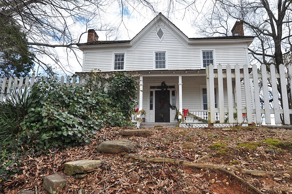
Listed on the National Register of Historic Places in 1977.
One of 18 National Register listings published here for Gwinnett County · listed in 1977 · category: Building.
Sources: the case file at the National Archives · the National Register database, National Park Service
Regional context, not property-specific evidence. The federal wildfire occurrence database lists 60 fires within 5 miles of Thomas Wynne House between 1992 and 2017, burning about 168 acres in total. 1 started naturally. 27 were recorded as arson. Distance is straight-line from the map coordinates, so a fire counted here may appear on a neighbouring settlement's page as well.
| Reported cause | Fires |
|---|---|
| Arson/incendiarism | 27 |
| Debris and open burning | 11 |
| Recreation and ceremony | 7 |
| Misuse of fire by a minor | 6 |
| Smoking | 3 |
| Equipment and vehicle use | 3 |
| Missing data/not specified/undetermined | 2 |
| Natural | 1 |
The most recent of them, most recent first, with the day each was reported and the service that recorded it.
| Date | Cause | Size | Reported by | Name on the report |
|---|---|---|---|---|
| 9 September 2007 | Arson/incendiarism | under an acre | Georgia Forestry Commission | not named |
| 22 August 1993 | Arson/incendiarism | 14 acres | Georgia Forestry Commission | not named |
| 21 August 1993 | Recreation and ceremony | 1.6 acres | Georgia Forestry Commission | not named |
| 2 August 1995 | Debris and open burning | under an acre | Georgia Forestry Commission | not named |
| 13 August 1995 | Arson/incendiarism | 1.2 acres | Georgia Forestry Commission | not named |
| 4 July 1996 | Recreation and ceremony | under an acre | Georgia Forestry Commission | not named |
| 30 July 2000 | Misuse of fire by a minor | 22 acres | Georgia Forestry Commission | FY2001-GWINNETT-004 |
| 27 July 1993 | Natural | under an acre | Georgia Forestry Commission | not named |
Regional context, not property-specific evidence. The federal mineral resources record lists 2 workings within 5 miles of Thomas Wynne House: 2 producers. All of them still produce. What was taken out: Stone, Crushed/Broken. Distance is straight-line from the map coordinates, so a quarry counted here may appear on a neighbouring settlement's page as well.
| Where | Site | Commodity | Status | Recorded |
|---|---|---|---|---|
| Norcross Quarry | Stone, Crushed/Broken | Producer | ||
| Norcross Shops | Stone, Crushed/Broken | Producer |
Regional context, not property-specific evidence. The National Weather Service names Lilburn, the town this property stands in, in 60 storm reports between 1995 and 2024: 26 thunderstorm wind, 17 hail, 12 lightning, 2 funnel cloud. The reports record 1 death and 2 injuries. Each account below is quoted exactly as the forecast office filed it, from the NOAA Storm Events Database, and each date opens the federal record of that event.
| When | Event | Place named | Harm | What the report says |
|---|---|---|---|---|
| September 1997 | Lightning | Lilburn | 1 killed, 1 hurt | Lightning struck two men as they were roofing a new home. A 17 year old male was injured and a29 yer old male died the next day. |
| July 2010 | Thunderstorm Wind | Lilburn | 1 hurt, $25,000 | The Gwinnett County 911 Center reported that several power lines were down near Rockbridge Road and Lawrenceville Highway near Lilburn. A large tree fell on a vehicle at the entrance to the Idlewylde Apartments on Boggs Road in Duluth. The adult male inside was pinned in the vehicle and had to be extricated by fire officials. Two power lines were also down on South Old Peachtree Road just east-northeast of Duluth. At least one tree was also down on Princess South, just northeast of Lilburn. |
| February 2009 | Hail | Lilburn | $2,500,000 | A deputy with the Gwinnett County Sheriff's office observed larger than golf ball-sized hail in the Lilburn area. The Gwinnett County 911 Center relayed reports of quarter-sized hail near Lilburn. Approximately three miles southwest of Snellville, a trained spotter observed quarter-sized hail. Hail up to three inches in diameter was reported just across the border in Loganville in Walton county as the storm continued moving east-southeast. |
| April 2009 | Hail | Lilburn | $1,500,000 | The public observed golf ball-sized hail just west of Snellville and half-dollar-sized hail in the Snellville area. Amateur radio operators reported quarter-sized hail in the Lilburn area. |
| May 2008 | Hail | Lilburn | $1,500,000 | The public observed golf ball-sized hail just south of Lilburn, quarter-sized hail just north of Snellville, and penny-sized hail near Grayson. |
| June 2018 | Thunderstorm Wind | Lilburn | $500,000 | A National Weather Service survey determined that a strong downburst with maximum winds up to 90 mph swept across central and south Gwinnett County from the Lilburn area to Snellville. Damage was found along a path approximately 6 miles long and 2 miles wide. Hundreds of trees and numerous power lines and power poles were blown down along this path. In total, 38 homes were damaged, including 12 with major damage and 2 that were destroyed. Most of the damage to structures, and much of the damage to power lines, was due to falling trees. Several vehicles were also damaged by falling trees. The worst damage was concentrated in the Killian Hill Manor subdivision along Hale Drive SW and along Cedar Wood Drive SW at the onset of the downburst. No injuries were reported. |
| May 2011 | Thunderstorm Wind | Lilburn | $350,000 | The Gwinnett County 911 Center, WSB Television of Atlanta, and the public reported that at least 30 trees were down across the county, several of which fell on and caused significant damage to homes. Two homes in Snellville were suffered damage from downed trees on the structures, with one additional incident each in Duluth and Norcross. |
| June 2008 | Lightning | Lilburn | $350,000 | The Gwinnett Daily Post of Lawrenceville reported that lightning struck three homes, one in the 5300 block of Candle Berry Drive, another in the 4600 block of Warrior Trail, and a third in the 1500 block of Rivermist Drive. The home on Candle Berry Drive sustained minor to moderate damage to the basement. At the other two locations, damage was confined to detached garages, each sustaining moderate damage. |
| April 2009 | Lightning | Lilburn | $300,000 | The Gwinnett County 911 Center reported that lightning struck a home on Riverwalk Trail just off Annistown Road. The roof collapsed as as a result of the fire and the home was destroyed. |
| July 2004 | Lightning | Lilburn | $275,000 | The Atlanta Journal-Constitution reported that lightning struck three homes in Gwinnett county during the late afternoon and evening. Two homes were struck in Lilburn and a third home was struck in Snellville. The home in Snellville suffered extensive damage because of the resulting fire. Only minor damage was reported to the homes in Lilburn. A fireman suffered heat-related injuries while fighting the fire at the home in Snellville. |
| April 2019 | Thunderstorm Wind | Lilburn | $250,000 | The Gwinnett County Emergency Manager relayed widespread reports of numerous trees and power lines blown down across Gwinnett County from the Stone Mountain area to Buford. This swath of damage stretched nearly 22 miles long and spanned 10 to 12 miles in width. At an apartment complex in Duluth, a large tree fell onto a car with 3 occupants. Two of the occupants were unhurt while paramedics treated one on the scene for minor injuries. |
| August 2010 | Lightning | Lilburn | $200,000 | The Gwinnett Daily Post of Lawrenceville reported that lightning struck a home on Hambrick Drive. The lightning struck the attic area of the home. The resulting fire caused extensive damage to the attic and moderate damage to the second floor of the home. |
| June 2006 | Lightning | Lilburn | $200,000 | The Gwinnett Daily Post and the Atlanta Journal-Constitution reported that lightning struck and destroyed a home on Meadow Way. |
| April 2014 | Thunderstorm Wind | Lilburn | $150,000 | The Gwinnett County Emergency Manager reported that 16 trees and 18 powerlines were blown down. Six of the trees fell on houses. Damage was spread throughout the county. |
| June 2007 | Lightning | Lilburn | $150,000 | The Gwinnett Daily Post reported that lightning struck a home on Cross Creek Drive. The resulting fire caused heavy damage to the attic area. |
| March 2007 | Lightning | Lilburn | $150,000 | The Gwinnett Daily Post of Lawrenceville reported that lightning struck a home on Rivermist Drive causing smoke and fire damage to the roof and attic as well as heavy damage to the second floor. Two adults living in the home escaped without injury. |
| April 2006 | Thunderstorm Wind | Lilburn | $150,000 | The public reported extensive damage to trees and homes in the Oak View Court area northeast of Lilburn between Beaver Ruin Road and Pleasant Hill Road, north of Lawrenceville Highway. Ten homes were damaged from downed trees, with tree and minor non-structural property damage reported at a total of 35 residences. A number of large 75 to 100 foot trees were down, including several 100-year-old Oak trees. Power lines were also down in the area. Several roads were blocked by fallen trees and power lines during the height of the storm. A storm spotter estimated winds in the Grayson area just to the east at 60 mph. |
| August 2009 | Thunderstorm Wind | Lilburn | $125,000 | Fox 5 Television of Atlanta relayed a report from the Gwinnett Fire and Rescue Department of a downed tree from thunderstorm wind gusts causing damage to a house in the 1700 block of Litchfield Road in Snellville. The large tree fell on the house and caused significant damage to the roof, resulting in subsequent water damage. In addition, several power lines were down in the Arcado Road area of Lilburn. Wind gusts of 54 mph were measured near the intersection of Lawrenceville Highway and Pleasant Hill Road. |
| July 1997 | Lightning | Lilburn | $80,000 | Within a thirty minute period, lightning struck more than 9 homes and/or businesses in Gwinnett county. Lightning also struck several transformers, leaving more than 5,000 people without power at the height of the storm. Power was restored to most people by 10 pm that evening. At least 5 transformers were damaged. |
| April 2002 | Lightning | Lilburn | $50,000 | The Gwinnett Daily Post in Lawrenceville reported that lightning struck and set on fire a two-story brick home in Lilburn. The home suffered heavy damage to the attic and roof and personal belongings. |
| May 1999 | Hail | Lilburn | $50,000 | Numerous public reports indicated large hail ranging from dime to golf ball size up to as large as baseball size fell across Gwinnett county. Vehicles were damaged. |
| June 2019 | Thunderstorm Wind | Lilburn | $25,000 | The Gwinnett County Emergency Manager reported numerous trees blown down across the county from Duluth to Dacula and Centerville to Buford. |
| April 2011 | Thunderstorm Wind | Lilburn | $25,000 | The Gwinnett County 911 Center reported that five trees and power lines were down across a couple of roads, mainly around Lawrenceville. One of the trees fell on a van causing damage to the vehicle. An amateur radio operator measured a wind gust of 55 mph on U.S. Highway 29 near Harbins Road. |
| August 1996 | Thunderstorm Wind | Lilburn | $20,000 | no account filed |
| August 2002 | Thunderstorm Wind | Lilburn | $15,000 | The public reported that at least four trees were down, two on homes causing minor damage to the structures. In addition, power lines were down in the same area. There were also reports of tree limbs down and tree limbs down on power lines. One road was also reported to be blocked by a downed tree. |
| August 2013 | Lightning | Lilburn | $10,000 | The Gwinnett County Emergency Manager reported that lightning started a small fire at a house on Lakeshore Drive. |
| June 2011 | Thunderstorm Wind | Lilburn | $10,000 | The Gwinnett County 911 Center reported that at least six trees and five power lines were down, especially in the western half of the county. WSR-88D base velocity data suggests that strong winds likely continued across the entire county as a strong gust front associated with a line of thunderstorms. |
| February 1999 | Thunderstorm Wind | Lilburn | $10,000 | A newspaper report indicated a tree fell on a house on Jennings Way off Jimmy Carter Blvd, and a tree fell on a car at Arbor Drive and Breckenridge. |
| March 2018 | Thunderstorm Wind | Lilburn | $8,000 | The Gwinnett County Emergency Manager reported trees blown down around the intersection of Harmony Grove Road and Rosser Court and power lines blown down near the intersection of Stone Drive SW and Hudson Road SW. |
| July 1997 | Thunderstorm Wind | Lilburn | $6,000 | Thunderstorm winds knocked over a 14 year old Bradford Pear tree. Limbs from several pine trees were also snapped. |
| June 2019 | Thunderstorm Wind | Lilburn | $2,000 | The Gwinnett County Emergency Manager reported power lines blown down across the road at Old Jordan Road SW and Old Tucker Road SW. |
| April 1997 | Hail | Lilburn | $2,000 | no account filed |
| February 2024 | Thunderstorm Wind | Lilburn | $1,000 | Tree down at the intersection of Oneta Dr and Williams Rd. |
| February 2024 | Thunderstorm Wind | Lilburn | $1,000 | Tree and wires reported down in the Road on Rolling Way NW. |
| February 2024 | Thunderstorm Wind | Lilburn | $1,000 | Tree reported down near the intersection of Stoneview Dr SW and Bailey Dr SW. |
| August 2024 | Thunderstorm Wind | Lilburn | $1,000 | Tree down along the road and on powerline near the intersection of miller rd sw and castle walk cove sw. |
| August 2005 | Thunderstorm Wind | Lilburn | $1,000 | The Gwinnett County Emergency Management Director reported that a tree and a power line were down on Whited Way. |
| August 2005 | Thunderstorm Wind | Lilburn | $1,000 | The public reported that four trees were blown down in the Lilburn area. |
| July 1999 | Thunderstorm Wind | Lilburn | $1,000 | Gwinnett county 911 reported trees and power lines blown down. |
| June 1995 | Thunderstorm Wind | Lilburn | $1,000 | Thunderstorm winds knocked down numerous trees between Liliburn and Lawrenceville. |
| May 2002 | Lightning | Lilburn | $500 | The public reported that lightning either struck a home or near enough the home to cause some minor electrical damage to a wall switch and blew out a television. No fire ensued and no injuries were reported. |
| August 2023 | Thunderstorm Wind | Lilburn | - | Multiple trees down in the area northwest of Lilburn including the 6200 block of Forest Vale Court, intersection of Tug Drive and Rockbridge Road and the 600 block of Stoneview Terrace. |
| April 2013 | Hail | Lilburn | - | The public reported quarter sized hail at Stone Mountain Road and Rockbridge Road. |
| January 2006 | Hail | Lilburn | - | The public reported penny to quarter-sized hail. |
| August 2005 | Funnel Cloud | Lilburn | - | The public reported sighting a funnel cloud at the intersection of U.S. Highway 29 and Beaver Run Road, just northeast of Lilburn. National Weather Service Doppler radar detected a definite mesocyclone in the area at the time. |
| August 2004 | Heavy Rain | Lilburn | - | Spotters with the Gwinnett County SkyWarn reported that heavy rain had resulted in several roads being flooded. The most significantly impacted roads were Beaver Run at Burns Road in Lilburn and New Hope Road in Grayson. |
| July 2002 | Hail | Lilburn | - | Amateur radio operators reported dime size hail at two separate locations in Lilburn, while quarter size hail was reported on Interstate 85 just south of Mechanicsville near the Gwinnett-Dekalb county line. |
| July 2002 | Flood | Lilburn | - | An amateur radio operator reported localized street flooding on U.S. Highway 29/Georgia Highway 8, Lawrenceville Highway, in Lilburn. |
| August 2002 | Thunderstorm Wind | Lilburn | - | The public reported pea size hail. |
| January 2000 | Hail | Lilburn | - | Several public reports indicated hail ranging from dime size to half dollar size fell in Lilburn, Duluth, Lawrenceville, and Dacula. |
| July 2000 | Flood | Lilburn | - | The Gwinnett county 911 center reported minor street flooding. In addition a tree was knocked down during the thunderstorm. |
| September 1999 | Hail | Lilburn | - | Two public reports indicated dime and golf ball size hail. |
| June 1999 | Hail | Lilburn | - | The public reported dime size hail. |
| May 1999 | Funnel Cloud | Lilburn | - | The public reported funnel clouds near Lilburn and Brookwood. |
| July 1999 | Hail | Lilburn | - | The public reported quarter size hail. |
| August 1999 | Hail | Lilburn | - | The public reported dime and nickel size hail. |
| May 1998 | Hail | Lilburn | - | Numerous reports of dime to quarter size hail were received from the public. |
| April 1998 | Hail | Lilburn | - | no account filed |
| July 1997 | Hail | Lilburn | - | no account filed |
| June 1995 | Hail | Lilburn | - | no account filed |
No historic map-sheet match is published for this property yet. That does not mean no map exists. This record needs a coordinate-quality review before it can be joined to a sheet boundary. Browse the county's mapped places while that work is pending.
Other National Register properties close enough to walk or drive between, ordered by distance from this one. Both positions come from the same geocoding pass that matched these properties to their map sheets.
| Photograph | Property | Distance | Listed |
|---|---|---|---|
| Hudson-Nash House and Cemetery | 4.1 miles | 1990 | |
| Norcross Historic District | 5.2 miles | 1980 | |
 | Superb, The | 6.3 miles | 1999 |
 | Mechanicsville School | 6.6 miles | 1980 |
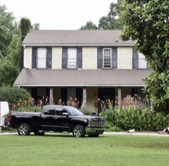 | Robert Craig Plantation | 7.0 miles | 1990 |
| National Archives record | The nomination case file for reference 77000436 in Record Group 79. |
| Gwinnett County | All 18 listed properties in this county. |