 Block
From the record
10 National Register listings published here, 1 of them a National Historic Landmark.
Sources: the National Register database, National Park Service
35 topographic sheets cover 24 settlements here, and 10 properties are on the National Register of Historic Places.
10 National Register listings published here, 1 of them a National Historic Landmark.
Sources: the National Register database, National Park Service
Every property in this county listed on the National Register of Historic Places, with the year it was listed and the federal nomination document.
| Photograph | Property | Type | Listed | Reference |
|---|---|---|---|---|
| E. J. Baird House | building | 1982 | 82002622 | |
 | David and M. Maria Hughes House | building | 1996 | 96000697 |
 | Iowa County Courthouse | building | 1981 | 81000247 |
 | Ladora Savings Bank | building | 1990 | 90001196 |
| Lenox Township Church of the New Jersalem | building | 1983 | 83000370 | |
| Pilot Grove | site | 1977 | 77000519 | |
| Plagmann Round Barn | building | 1986 | 86001440 | |
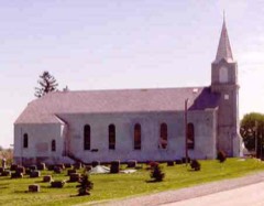 | St. Michael's Church, Cemetery, Rectory and Ancient Order of Hibernians Hall | building | 1983 | 83000371 |
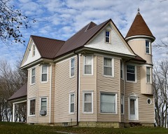 | Fred G. Turner House | building | 1985 | 85001381 |
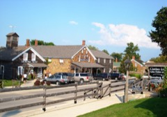 | Upper South Hotel | building | 1966 | 66000336 |
Every wildfire the federal occurrence database records inside this county: 199 of them, burning about 3,402 acres. None started naturally and 1 was recorded as arson. Each settlement page carries the fires within five miles of it.
| Reported cause | Fires |
|---|---|
| Missing data/not specified/undetermined | 116 |
| Debris and open burning | 70 |
| Smoking | 5 |
| Equipment and vehicle use | 3 |
| Recreation and ceremony | 1 |
| Power generation/transmission/distribution | 1 |
| Misuse of fire by a minor | 1 |
| Railroad operations and maintenance | 1 |
| Arson/incendiarism | 1 |
The five largest, by the area the report gives. One of them was set deliberately.
| Date | Cause | Size | Reported by | Name on the report |
|---|---|---|---|---|
| 3 April 2011 | Missing data/not specified/undetermined | 824 acres | Port Louisa National Wildlife Refuge | ACE AUTO |
| 15 March 2006 | Missing data/not specified/undetermined | 360 acres | Port Louisa National Wildlife Refuge | SCHOTT WILDFIRE |
| 23 April 2018 | Debris and open burning | 316 acres | Port Louisa National Wildlife Refuge | SCHOTT WF |
| 19 April 2020 | Debris and open burning | 228 acres | Port Louisa National Wildlife Refuge | CAES NW |
| 30 March 2014 | Debris and open burning | 160 acres | Iowa Department of Natural Resources | not named |
| 19 March 2017 | Debris and open burning | 120 acres | Iowa Department of Natural Resources | not named |
| 1 April 2005 | Arson/incendiarism | 92 acres | Port Louisa National Wildlife Refuge | KOSZTA BOAT RAMP 2 |
| 20 April 2005 | Missing data/not specified/undetermined | 86 acres | Port Louisa National Wildlife Refuge | ACE AUTO 2 |
Every settlement page carries the fires within five miles of it - see the settlement index below.
The NOAA Storm Events Database holds 371 reports for this county, causing no deaths, 22 injuries and about $38,484,000 in recorded property damage. Each settlement page carries the reports that name it.
| Kind of event | Reports |
|---|---|
| Thunderstorm Wind | 143 |
| Hail | 125 |
| Flash Flood | 37 |
| Tornado | 34 |
| Flood | 21 |
| Funnel Cloud | 4 |
| Heavy Rain | 4 |
| Lightning | 2 |
| Winter Weather | 1 |
The most serious of them, by death, then injury, then recorded damage. The accounts are quoted exactly as the forecast office filed them.
| When | Event | Place named | Harm | What the report says |
|---|---|---|---|---|
| June 1998 | Thunderstorm Wind | Countywide | 9 hurt, $800,000 | no account filed |
| April 1973 | Tornado (F2) | not stated | 6 hurt | no account filed |
| August 1974 | Tornado (F4) | not stated | 2 hurt, $250,000 | no account filed |
| August 1989 | Thunderstorm Wind | not stated | 2 hurt | no account filed |
| May 2008 | Thunderstorm Wind | Millersburg | 1 hurt, $10,000 | Winds estimated to be 65 mph destroyed a machine shed a couple of miles southwest of Millersburg, IA around 11:15 pm on May 25th. According to emergency management officials, a man was injured and taken to a hospital after being hit by a tree limb. |
| June 2001 | Thunderstorm Wind | Victor | 1 hurt | Three semi-tractor trailers were blown over on Interstate 80 at mile marker 209. The semis were blocking all lanes and the highway was closed for a time. One of the drivers was injured. Reported by law enforcement. |
| September 2001 | Thunderstorm Wind | Williamsburg | 1 hurt | Thunderstorm wind gusting to 60 mph downed a tree, which fell on a person, who required treatment at a local hospital. Reported by law enforcement. |
| June 1984 | Tornado (F4) | not stated | $25,000,000 | no account filed |
| May 1988 | Tornado (F2) | not stated | $2,500,000 | no account filed |
| April 2011 | Hail | Homestead | $1,000,000 | Golf ball sized hail fell 2 miles south of Amana, IA around 625 pm CDT April 3. |
| May 2003 | Hail | Williamsburg | $1,000,000 | no account filed |
| June 2007 | Flash Flood | Marengo | $750,000 | Eight to 12 inches of rain fell in the Marengo area, causing widespread major flash flooding throughout town. Water covered numerous roads, closing them or making them completely impassable. Some homes were surrounded by water up to 3 feet deep. The National Guard was activated to pump water from the town. Due to incredible local run-off, the Iowa River in Marengo rose from 11.4 feet to 17 feet in just 5 hours. (Flood stage is 14 feet.) The river eventually crested at 17.46 feet the morning of the 23rd. Some residents described the flooding of the town as worse than 1993, and in fact worse than had been seen for more than 40 years. |
| June 2008 | Flood | Koszta | $747,000 | The record crest on the Iowa River at Marengo occurred on June 12, 2008 at 21.38 feet. Flood stage is 14 feet. |
| June 2010 | Flood | Koszta | $500,000 | Heavy rains during the third week of June resulted in the Iowa River at Marengo going above the moderate flood stage level of 15.5 feet on June 14th around 11 pm. It crested around 17.5 feet around 100 am June 24. It remained above the moderate flood stage level through the end of June. |
| May 2010 | Flood | Koszta | $500,000 | Heavy rains during the second week of May resulted in the Iowa River at Marengo going above the moderate flood stage level of 15.5 feet on May 13th around 800 am. It crested around 16.5 feet around 100 am May 19. It fell below the moderate flood stage level around 100 am May 22. |
| May 2009 | Flood | Koszta | $500,000 | Heavy rains during the last week of April resulted in the Iowa River at Marengo going above the moderate flood stage level of 15.5 feet on April 29th around 2 am. It crested around 17.64 feet around 9 pm April 30. It finally fell below the moderate flood stage level around 2 am May 7. |
| June 2009 | Flood | Koszta | $500,000 | Heavy rains during the middle of the month resulted in the Iowa River at Marengo going above the moderate flood stage level of 15.5 feet on June 19th around 8 pm. It crested around 16.1 feet around 4 am June 20 and again around 16.2 feet around 730 am June 24. It finally fell below the moderate flood stage level around 230 am June 26. |
| August 2009 | Flood | Koszta | $500,000 | no account filed |
| May 2003 | Hail | North English | $500,000 | no account filed |
| May 2011 | Tornado (EF2) | Koszta | $250,000 | A National Weather Service storm damage survey team determined that a track of EF2 damage extended from 3 miles northwest of Ladora, IA to 6 miles northwest of Marengo, IA. This path is roughly 4 miles long and 75 yards wide. This damage occurred approximately between 240 pm and 245 pm CDT May 22. ||Along the path, trees were damages, portions of a house roof were blown off, and a string of 12 power poles were snapped. Based on the damage, wind speeds were estimated at 120 mph. |
| June 2009 | Flash Flood | Marengo | $250,000 | Heavy rains have resulted in flash flooding of several streets in Marengo, IA during the evening of June 21 and early morning hours of June 22. Flood waters were 8 to 12 inches deep. |
| August 2010 | Flood | Koszta | $250,000 | no account filed |
| July 2010 | Flood | Koszta | $250,000 | no account filed |
| April 1991 | Tornado (F2) | not stated | $250,000 | no account filed |
| April 1991 | Tornado (F1) | not stated | $250,000 | no account filed |
| June 1986 | Tornado (F1) | not stated | $250,000 | no account filed |
| June 1986 | Tornado (F1) | not stated | $250,000 | no account filed |
| June 1984 | Tornado (F1) | not stated | $250,000 | no account filed |
| April 1981 | Tornado (F1) | not stated | $250,000 | no account filed |
| August 2010 | Flash Flood | Koszta | $100,000 | Heavy rains resulted in flash flooding of parts of North English and surrounding areas during the early morning hours of August 3. A bridge in North English had water flowing over it. In addition, the first floor of an apartment building flooded. Just east of town, Highway F67 was closed due to water across the road. In addition, several county roads had rock washed away and were in need of repair, including the 411 bridge on M Avenue north of Marengo and the squirrel bridge near North English. |
| June 2010 | Flash Flood | Marengo | $100,000 | Heavy rains resulted in flash flooding in Marengo, IA during the morning of June 23. Streets were full of flood water and sewers were bubbling over. In addition, major street flooding with water 12 to 14 inches deep was observed about 4 miles north of Marengo. A trained spotter also contributed to this report. |
| May 2008 | Tornado (EF1) | Victor | $100,000 | A tornado moved east just south of I 80 from mile marker 205 south of Victor, IA to mile marker 211 south of Ladora, IA. Several gin bins and other farm outbuildings were either damaged or destroyed. Some utility poles and trees along the path were blown down and at least one home sustained roof damage. One tree fell onto a mobile home destroying it. |
| June 2009 | Flash Flood | Marengo | $50,000 | Heavy rains resulted in flash flooding of one lane of Highway 6 in Marengo, IA during the late afternoon and early evening of June 19. |
| June 2009 | Flash Flood | Amana | $50,000 | Heavy rains resulted in flash flooding of the intersection of Middle and Main in Amana, IA during the late afternoon and evening of June 19. |
| July 2003 | Thunderstorm Wind | Ladora | $50,000 | no account filed |
| April 2003 | Hail | Victor | $50,000 | no account filed |
| May 1996 | Lightning | North English | $50,000 | no account filed |
| August 2004 | Flash Flood | Middle Amana | $40,000 | Between 2145 CST and 2245 CST, spotters reported that 4.5 to 5.5 inches of rain fell in the Amana's Colonies in Northeast Iowa County. A road was closed due to high water in Middle Amana and a nursing home was flooded with water up to 6 inches deep, including the kitchen and welcome areas. A small recreational dam on a pond between Middle Amana and High Amana broke flooding the immediate area. |
| July 2008 | Thunderstorm Wind | Williamsburg | $25,000 | Wind gusts estimated to be 70 mph blew the roof off of a car wash about 1 mile north of Williamsburg, IA around 445 am July 21. This report was relayed by a broadcast media partner. |
| November 1988 | Tornado (F1) | not stated | $25,000 | no account filed |
| August 1979 | Tornado (F1) | not stated | $25,000 | no account filed |
| August 1977 | Tornado | not stated | $25,000 | no account filed |
| May 1971 | Tornado (F1) | not stated | $25,000 | no account filed |
| June 1970 | Tornado (F0) | not stated | $25,000 | no account filed |
| September 2000 | Thunderstorm Wind | North English | $20,000 | Large tree fell on a home. |
| June 2011 | Lightning | Marengo | $15,000 | Lightning struck a tree which then fell onto a car in Marengo, IA at 130 am CDT June 21. This report was relayed by KCRG-TV. |
| July 2006 | Thunderstorm Wind | Marengo | $15,000 | Trees & limbs down; roof partially off a business |
| May 2017 | Thunderstorm Wind | Marengo | $10,000 | The county emergency manager reported power poles and trees were snapped from Ladora to Marengo. Some of these trees fell on houses and other buildings. |
| May 2011 | Tornado (EF0) | Millersburg | $10,000 | A National Weather Service storm damage survey team confirmed an EF0 tornado track from 3 miles east of Millersburg, IA (tornado began at 254 pm) to 3 miles west of Parnell, IA (tornado ended at 3 pm). The path length was about 2 miles and the path width was about 25 yards. Power lines were blown down with tree damage noted and one shed flipped. Based on the damage, wind speeds in the tornado were estimated at 80 mph. |
| June 2007 | Flash Flood | Marengo | $10,000 | A hog farm north of Marengo suffered a severe flash flood. The flood waters washed away and destroyed a hog building with about 100 hogs inside it. Over the next few days, all but 7 of the hogs were recovered alive. Residents described wading into chest-high water in an attempt to save the animals before they were swept away. |
| June 2007 | Flash Flood | Marengo | $10,000 | A hog farm north of Marengo suffered a severe flash flood. The flood waters washed away and destroyed a hog building with about 100 hogs inside it. Over the next few days, all but 7 of the hogs were recovered alive. Residents described wading into chest-high water in an attempt to save the animals before they were swept away. |
| May 2004 | Tornado (F1) | Williamsburg | $10,000 | Also reported by Chaser |
| July 1999 | Thunderstorm Wind | North English | $10,000 | Downburst winds blew the roof off a farrowing house in rural North English and snapped large tree limbs in North English proper. |
| May 2004 | Thunderstorm Wind | Marengo | $8,000 | Semi blown over with power out. |
| May 2004 | Thunderstorm Wind | Victor | $7,000 | Power out |
| August 2009 | Thunderstorm Wind | Victor | $5,000 | Wind gusts estimated to be 70 mph blew down trees limbs and power lines in the vicinity of Victor, IA around 731 pm August 9. |
| April 2006 | Hail | Amana | $5,000 | golfball size hail |
| August 2006 | Thunderstorm Wind | Amana | $5,000 | Law enforcement reported trees down along Avenue T (county highway 20). |
| May 2004 | Thunderstorm Wind | Millersburg | $5,000 | Trees down in road and power out. |
| April 2006 | Hail | Marengo | $5,000 | no account filed |
The Survey's mineral resources record lists 6 workings inside this county. 2 still produce and 4 are closed or unrecorded. Each settlement page carries the workings within five miles of it.
| Commodity | Workings |
|---|---|
| Sand and Gravel, Construction | 5 |
| Flagstone | 1 |
The least common of them first, because a county's hundredth gravel pit says nothing its first ten did not.
| Where | Site | Commodity | Status | Recorded |
|---|---|---|---|---|
| Amana Sandstone Quarries | Flagstone | Past Producer | ||
| Ghueren Pit | Sand and Gravel, Construction | Past Producer | ||
| Marengo Pit | Sand and Gravel, Construction | Past Producer | ||
| Marengo Sand Pit | Sand and Gravel, Construction | Producer | ||
| Marengo Sand Pit and Plant | Sand and Gravel, Construction | Producer | ||
| Unknown | Sand and Gravel, Construction | Past Producer |
Named settlements recorded in the Geographic Names Information System, each with the topographic sheets covering it. Villages, hamlets and abandoned places alike. Each is shown with the nearest named watercourse or landform and the survey quadrangle it falls on.
Dayton township · 52355 · Millersburg quadrangle
8 sheets, 1954 to 1984
No longer a settlement
Dayton township · 52316 · Millersburg quadrangle
8 sheets, 1954 to 1984
No longer a settlement
Honey Creek township · 52208 · Hartwick quadrangle
8 sheets, 1954 to 1984
No longer a settlement
English township · 52316 · On Gritter Creek · North English quadrangle
8 sheets, 1954 to 1984
The vanished settlements of Iowa County: the places named above that are no longer on the map.