
BlockBefore
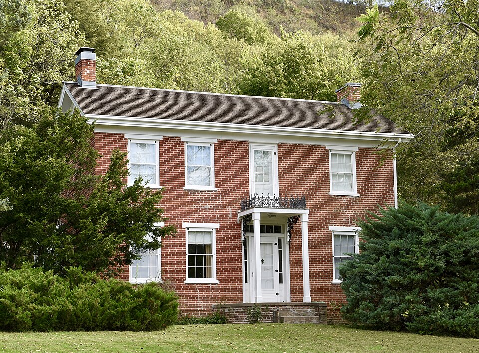
Photograph of Jason and Elizabeth Baylor Rector House
Photograph by Jim Roberts, CC BY-SA 4.0. Via Wikimedia Commons.

Jason and Elizabeth Baylor Rector House

Listed on the National Register of Historic Places in 2002.

From the record

“Jason and Elizabeth Baylor Rector House is a historic building located south of Thurman, Iowa, United States. Jason Rector is a native of Indiana who moved with his father, a Methodist minister, in the late 1840s to southwest Iowa.”

Wikipedia article Jason and Elizabeth Baylor Rector House, CC BY-SA 4.0.

One of 9 National Register listings published here for Fremont County · listed in 2002 · category: Building.

Sources: the Wikipedia article · the case file at the National Archives · the National Register database, National Park Service


The listing

  • What is counted as historic. The nomination lists 2 structuress, 1 building as contributing to the listing.
  • Listed as. Rector, Jason and Elizabeth Baylor, House - the National Register files a house under its owner's surname.
  • Address. 2174 Bluff Rd., Thurman, 51654
  • When was it listed? February 2002
  • Category. building
  • Township. Sidney township
  • Architectural style. Greek Revival architecture
  • National Register reference number. 01001542 - the number the National Park Service assigned this property when it was listed, and the key its nomination file is catalogued under at the National Archives.

Fires near this property

4 since 2006

Regional context, not property-specific evidence. The federal wildfire occurrence database lists 4 fires within 5 miles of Jason and Elizabeth Baylor Rector House between 2006 and 2020, burning about 68 acres in total. None started naturally. None was recorded as arson. Distance is straight-line from the map coordinates, so a fire counted here may appear on a neighbouring settlement's page as well.

Reported cause Fires
Missing data/not specified/undetermined2
Smoking1
Debris and open burning1

The most recent of them, most recent first, with the day each was reported and the service that recorded it.

DateCause SizeReported by Name on the report
5 March 2020Smoking43 acresIowa Department of Natural Resourcesnot named
18 March 2016Debris and open burning5.0 acresIowa Department of Natural ResourcesGLENWOOD FIRE DEPARTMENT
21 February 2013Missing data/not specified/undetermined20 acresIowa Department of Natural Resourcesnot named
20 February 2006Missing data/not specified/undeterminedunder an acreIowa Department of Natural Resourcesnot named

Every fire recorded in Fremont County

Storms near this property

24 since 1994

Regional context, not property-specific evidence. The National Weather Service names Thurman, the town this property stands in, in 24 storm reports between 1994 and 2025: 12 hail, 8 thunderstorm wind, 4 tornado. No death or injury is recorded in these reports. Each account below is quoted exactly as the forecast office filed it, from the NOAA Storm Events Database, and each date opens the federal record of that event.

WhenEvent Place namedHarm What the report says
June 1994HailThurman$50,000Warm, moist, and unstable air poured into Iowa during the day. By the early evening hours thunderstorms erupted over eastern Nebraska and southwest Iowa where convection broke through the capping layer. The storms produced hail over the far southwest corner of the state. The hail ranged from dime-size to golf ball-size. Considerable damage was reported to the crops in the area.
April 2025Tornado (EF0)Thurman-Approximately 7:13 PM CST on Thursday, April 17, 2025, a tornado formed 3 miles southwest of Tabor, IA. The tornado stirred up copious amounts of dust and dirt from recently plowed agricultural field. The tornado moved southeast across mainly agricultural fields until cross U.S. 275, producing EF-0 damage to roofs and farm outbuildings just south of 130th Street, reaching a width of about 1/4 mile. Based on video, the tornado weakened briefly east of U.S. 275 until it crossed 280th Avenue, where it again reached a width of about 1/4 mile and strengthened again before crossing 290th Avenue, producing EF-0 damage to trees and flipping irrigation pivots. The tornado continued until about the intersection of 300th Avenue and 140th Street where it dissipated at approximately 7:28 PM CST. The maximum wind speed during this track was estimated at 85 mph, 0 fatalities and 0 injuries.
June 2023Thunderstorm WindThurman-Emergency management relayed photos of numerous downed trees and branches in Thurman.
April 2023HailThurman-Public reported 3-inch hail near Thurman.
April 2023HailThurman-Trained spotter reported quarter size hail.
April 2023Tornado (EF0)Thurman-Multiple photographs and accounts from storm chasers and public confirm a tornado in this approximate location that lasted for approximately 3 minutes. No damage was reported with this tornado.
June 2017Thunderstorm WindThurman-Very large trees southwest of Thurman were blown down by damaging winds. Th trees were blocking a road.
June 2017Thunderstorm WindThurman-Several trees were blown down by damaging thunderstorm winds.
August 2015Thunderstorm WindThurman-Images from social media posts indicate that a downburst occurred in Thurman. Several large tree branches were blown down, and one tree was completely snapped.
April 2010Thunderstorm WindThurman-Thunderstorm winds estimated at 55 to 60 mph downed a tree limb around 2 inches in diameter.
April 2010HailThurman-Hail up to nickel size fell for about 10 minutes southwest of Thurman.
March 2006Thunderstorm WindThurman-Thunderstorm winds blew over a few grain bins and power lines near Thurman
May 2004Tornado (F0)Thurman-A tornado was followed by an Amatuer radio operator and reported by emergency management north of Thurman. The tornado lifted several times along its track and stayed in open country with no apparent damage reported.
April 2002Tornado (F0)Thurman-A brief touchdown of a tornado in open country just northeast of exit 20 on Interstate 29. The tornado was caught on film by a storm chaser.
June 2018Thunderstorm WindThurman-no account filed
June 2017HailThurman-no account filed
May 2007HailThurman-no account filed
March 2006HailThurman-no account filed
April 2005HailThurman-no account filed
May 2004HailThurman-no account filed
May 2004Thunderstorm WindThurman-no account filed
August 2003HailThurman-no account filed

Every storm recorded in Fremont County

Map coverage status

No historic map-sheet match is published for this property yet. That does not mean no map exists. This record needs a coordinate-quality review before it can be joined to a sheet boundary. Browse the county's mapped places while that work is pending.

Listed places nearby

2 within 8 miles

Other National Register properties close enough to walk or drive between, ordered by distance from this one. Both positions come from the same geocoding pass that matched these properties to their map sheets.

Photograph PropertyDistance Listed
Fremont County Courthouse3.6 miles1981
Chautauqua Pavilion7.6 miles1976

Sources for this property

National Archives recordThe nomination case file for reference 01001542 in Record Group 79.
Wikipedia articleCommunity-written account of this property, licensed CC BY-SA.
Fremont CountyAll 9 listed properties in this county.

Provenance

  • Listing record. National Park Service National Register of Historic Places, listed-properties dataset, current to 2026-05-22.
  • Map join. Address geocoded through the United States Census geocoder, then tested against the published boundary of every sheet in the USGS Historical Topographic Map Collection.
  • How this page is made. Listing fields come from federal records; map-sheet coverage is a labelled coordinate-to-boundary calculation, not a source-field claim.
  • Wildfire. Short, Karen C. 2022. Spatial wildfire occurrence data for the United States, 1992-2020 [FPA_FOD_20221014]. 6th Edition. Fort Collins, CO: Forest Service Research Data Archive. https://doi.org/10.2737/RDS-2013-0009.6 Collected with United States Government funding and usable without additional permissions or fees.
  • Storms. NOAA National Centers for Environmental Information, Storm Events Database https://www.ncei.noaa.gov/stormevents/ A work of the United States government, no copyright under 17 U.S.C. 105. Narratives are quoted verbatim from the National Weather Service report and are not edited or summarised.