 Block
From the record
One of 36 National Register listings published here for Winneshiek County · category: Building.
Sources: the case file at the National Archives · the National Register database, National Park Service
Listed on the National Register of Historic Places.
One of 36 National Register listings published here for Winneshiek County · category: Building.
Sources: the case file at the National Archives · the National Register database, National Park Service
Regional context, not property-specific evidence. The federal wildfire occurrence database lists 11 fires within 5 miles of Big Stone Mills between 2008 and 2020, burning about 323 acres in total. None started naturally. None was recorded as arson. Distance is straight-line from the map coordinates, so a fire counted here may appear on a neighbouring settlement's page as well.
| Reported cause | Fires |
|---|---|
| Missing data/not specified/undetermined | 6 |
| Debris and open burning | 5 |
The most recent of them, most recent first, with the day each was reported and the service that recorded it.
| Date | Cause | Size | Reported by | Name on the report |
|---|---|---|---|---|
| 19 September 2020 | Missing data/not specified/undetermined | under an acre | Iowa Department of Natural Resources | not named |
| 4 July 2008 | Missing data/not specified/undetermined | 10 acres | Iowa Department of Natural Resources | not named |
| 14 May 2012 | Debris and open burning | 12 acres | Iowa Department of Natural Resources | not named |
| 26 April 2020 | Debris and open burning | 50 acres | Iowa Department of Natural Resources | not named |
| 21 April 2020 | Debris and open burning | under an acre | Iowa Department of Natural Resources | not named |
| 17 April 2015 | Debris and open burning | 2.0 acres | Iowa Department of Natural Resources | not named |
| 15 April 2009 | Missing data/not specified/undetermined | 20 acres | Iowa Department of Natural Resources | not named |
| 15 April 2009 | Missing data/not specified/undetermined | 25 acres | Iowa Department of Natural Resources | not named |
Regional context, not property-specific evidence. The federal mineral resources record lists 8 workings within 5 miles of Big Stone Mills: 7 past producers, 1 producer. 1 still produces. What was taken out: Sand and Gravel, Construction, Stone, Crushed/Broken. Distance is straight-line from the map coordinates, so a quarry counted here may appear on a neighbouring settlement's page as well.
| Where | Site | Commodity | Status | Recorded |
|---|---|---|---|---|
| Horseshoe Bend Quarry | Stone, Crushed/Broken | Producer | ||
| Protivin Quarry | Stone, Crushed/Broken | Past Producer | ||
| Unknown | Stone, Crushed/Broken | Past Producer | ||
| Anderson Pit | Sand and Gravel, Construction | Past Producer | ||
| Protivin Pit | Sand and Gravel, Construction | Past Producer | ||
| Unknown | Sand and Gravel, Construction | Past Producer | ||
| Unknown | Sand and Gravel, Construction | Past Producer | ||
| Unknown | Sand and Gravel, Construction | Past Producer |
Regional context, not property-specific evidence. The National Weather Service names Spillville, the town this property stands in, in 24 storm reports between 1998 and 2025: 15 flood, 5 hail, 4 thunderstorm wind. No death or injury is recorded in these reports. Each account below is quoted exactly as the forecast office filed it, from the NOAA Storm Events Database, and each date opens the federal record of that event.
| When | Event | Place named | Harm | What the report says |
|---|---|---|---|---|
| May 2017 | Thunderstorm Wind | Spillville | $3,000 | Lots of trees were damaged in Spillville. |
| July 2017 | Thunderstorm Wind | Spillville | $3,000 | Numerous trees were blown down in Spillville. |
| June 2008 | Thunderstorm Wind | Spillville | $500 | A couple of trees were knocked down. |
| August 2025 | Flood | Spillville | - | Heavy rain during the middle of August allowed the Turkey River at Spillville to rise into flood stage during the morning on August 18th. The site crested at 11.23 ft in moderate flood stage during the early afternoon on August 18th before falling below flood stage during the early morning hours on August 20th. |
| June 2024 | Thunderstorm Wind | Spillville | - | Eight-inch diameter tree limbs were reported down. |
| August 2021 | Flood | Spillville | - | Runoff from heavy rains pushed the Turkey River out of its banks in Spillville. The river crested over six feet above the flood stage at 15.1 feet on the 28th. |
| June 2020 | Flood | Spillville | - | Runoff from the heavy rains associated with Tropical Depression Cristobal pushed the Turkey River out of its banks twice in Spillville. The first crest was almost two and half feet above the flood stage at 11.4 feet on the 10th. The second crest was around a quarter of a foot above the flood stage at 9.23 feet, also on the 10th. |
| March 2019 | Flood | Spillville | - | Runoff from rain and melting snow pushed the Turkey River out of its banks in Spillville. The river crested over three feet above the flood stage at 12.1 feet on March 15th. |
| May 2019 | Flood | Spillville | - | Runoff from heavy rain pushed the Turkey River out of its banks in Spillville. The river crested less than a half foot above the flood stage at 9.13 feet. |
| June 2019 | Flood | Spillville | - | Runoff from heavy rains pushed the Turkey River out of its banks in Spillville. The river crested almost two feet above the flood stage at 10.82 feet. |
| September 2018 | Flood | Spillville | - | Runoff from heavy rains pushed the Turkey River out of its banks in Spillville. The river crested a half foot above the flood stage at 9.5 feet on September 4th. The river briefly fell below flood stage before going out of its banks again. The second crest was over four and a half feet above the flood stage at 13.67 feet on September 6th. |
| May 2018 | Flood | Spillville | - | Runoff from heavy rain pushed the Turkey River out of its banks in Spillville. The river crested over five feet above the flood stage at 14.42 feet on the 4th. Several fire departments and law enforcement agencies help residents sandbag against the flooding. |
| September 2018 | Flood | Spillville | - | Runoff from heavy rains pushed the Turkey River out of its banks in Spillville. The river crested less than a foot above the flood stage at 9.66 feet on September 21st. |
| October 2018 | Flood | Spillville | - | Runoff from heavy rains pushed the Turkey River out of its banks in Spillville. The river crested less than a foot above the flood stage at 9.8 feet on October 10th. |
| May 2017 | Hail | Spillville | - | Quarter to walnut sized hail fell in Spillville. |
| September 2016 | Flood | Spillville | - | Heavy rains in the upper reaches of the Turkey River caused a short period of flooding in Spillville. The river crested just over the flood stage at 9.14 feet. |
| September 2016 | Flood | Spillville | - | Runoff from heavy rain pushed the Turkey River out of its banks in Spillville. The river crested almost five above the flood stage at 13.73 feet. |
| September 2016 | Flood | Spillville | - | Runoff from heavy rain pushed the Turkey River out of its banks in Spillville. The river crested five feet above the flood stage at 13.99 feet. This was the second time in two days that flooding occurred at this site. It had crested at 9.14 feet the day before. |
| August 2016 | Flood | Spillville | - | Runoff from heavy rains pushed the Turkey River out of its banks in Spillville. The river crested over eleven feet above the flood stage at 20.25 feet. This established a new crest of record. |
| July 2016 | Flood | Spillville | - | Runoff from heavy rain pushed the Turkey River out of its banks in Spillville. The river crested less than a half foot above the flood stage at 9.21 feet. |
| May 2002 | Hail | Spillville | - | no account filed |
| April 2002 | Hail | Spillville | - | no account filed |
| September 2001 | Hail | Spillville | - | no account filed |
| May 1998 | Hail | Spillville | - | no account filed |
No historic map-sheet match is published for this property yet. That does not mean no map exists. This record needs a coordinate-quality review before it can be joined to a sheet boundary. Browse the county's mapped places while that work is pending.
Other National Register properties close enough to walk or drive between, ordered by distance from this one. Both positions come from the same geocoding pass that matched these properties to their map sheets.
| Photograph | Property | Distance | Listed |
|---|---|---|---|
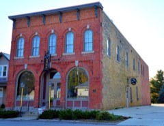 | Wenzil Taylor Building | 1.1 miles | 1979 |
 | Fort Atkinson Bridge | 4.6 miles | 1998 |
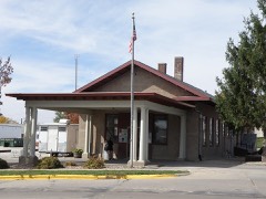 | Calmar Passenger Depot | 5.9 miles | 2011 |
| National Archives record | The nomination case file for reference 09000516 in Record Group 79. |
| Winneshiek County | All 36 listed properties in this county. |